The Valley Without Peril (Bay C5), after Cape of Good Hope |

  |
The Valley Without Peril (Bay C5), after Cape of Good Hope |
 Mar 29 2007, 04:49 AM Mar 29 2007, 04:49 AM
Post
#106
|
|
 Senior Member  Group: Members Posts: 2228 Joined: 1-December 04 From: Marble Falls, Texas, USA Member No.: 116 |
They deserve a day (or three) of rest. It appears that we'll need to be patient, waiting for that elminus view and the pancam foreground set.
-------------------- ...Tom
I'm not a Space Fan, I'm a Space Exploration Enthusiast. |
 |
 
|
|
Mar 29 2007, 09:31 AM
Post
#107
|
|
 Special Cookie Group: Members Posts: 2168 Joined: 6-April 05 From: Sintra | Portugal Member No.: 228 |
Is there anybosdy down there?...

-------------------- "Ride, boldly ride," The shade replied, "If you seek for Eldorado!"
Edgar Alan Poe |
|
|
|
|
Mar 29 2007, 09:44 AM
Post
#108
|
|
|
Senior Member Group: Moderator Posts: 4279 Joined: 19-April 05 From: .br at .es Member No.: 253 |
That image is an old one.
The new ones has a site/drive id "8153". Watch your step little rover!!!  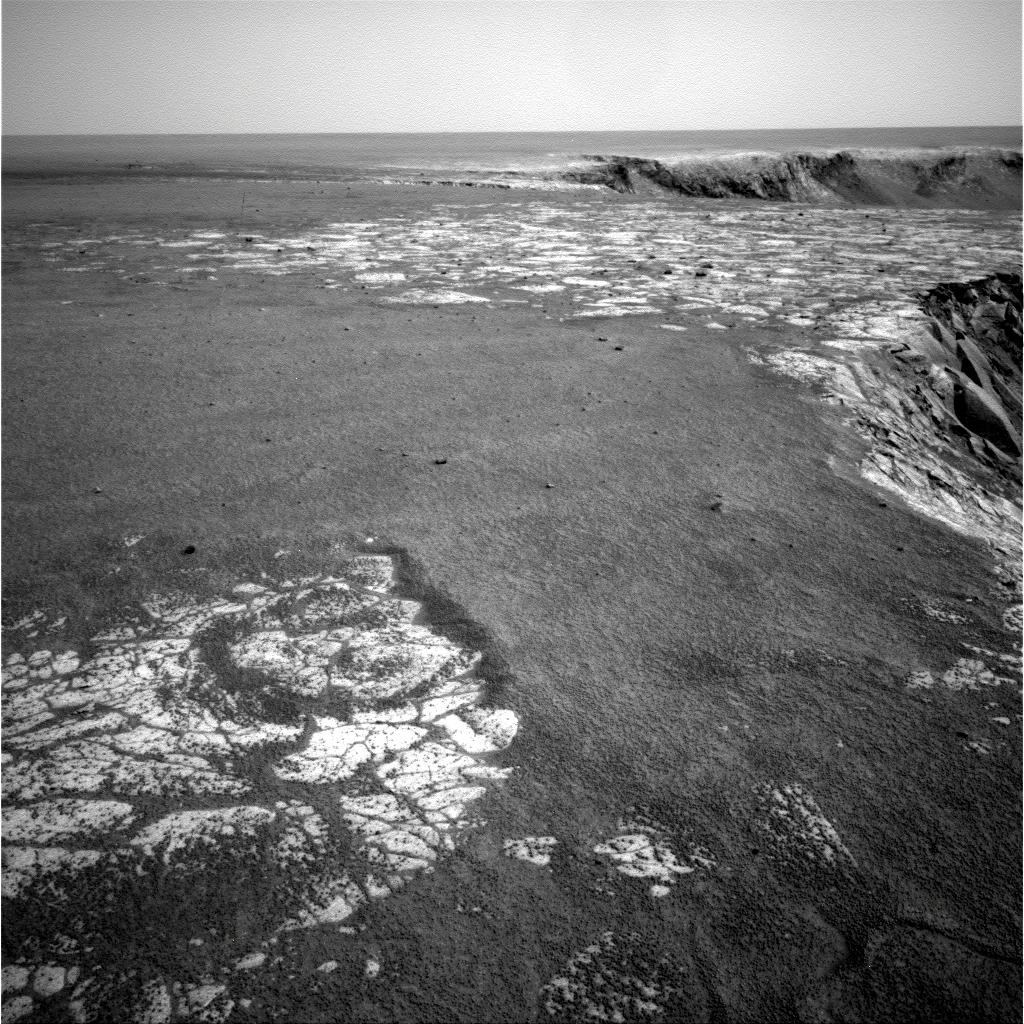 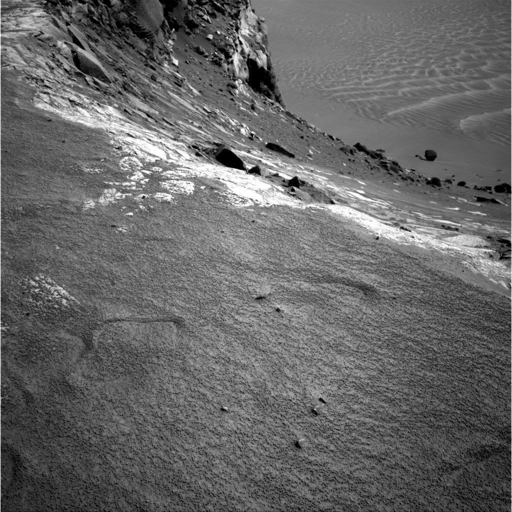 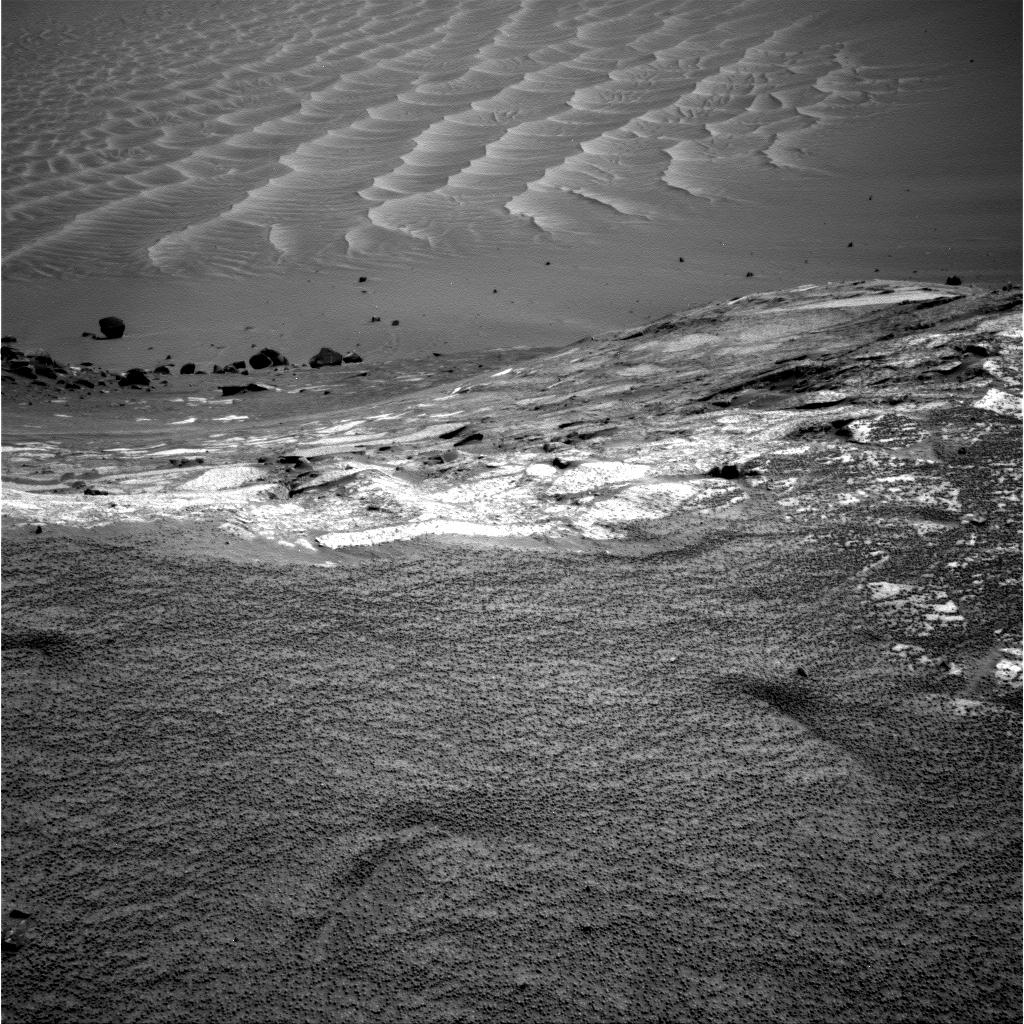
|
|
|
|
|
Mar 29 2007, 09:54 AM
Post
#109
|
||
|
Senior Member Group: Moderator Posts: 4279 Joined: 19-April 05 From: .br at .es Member No.: 253 |
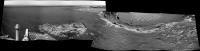
A quick autostitched mosaic...
Attached thumbnail(s)
|
|
|
|
|
|
|
Mar 29 2007, 10:06 AM
Post
#110
|
|
|
Special Cookie Group: Members Posts: 2168 Joined: 6-April 05 From: Sintra | Portugal Member No.: 228 |
That is REALLY scary!
...and thanks for the correction Tesheiner... -------------------- "Ride, boldly ride," The shade replied, "If you seek for Eldorado!"
Edgar Alan Poe |
|
|
|
|
Mar 29 2007, 12:35 PM
Post
#111
|
|
|
Member Group: Members Posts: 910 Joined: 4-September 06 From: Boston Member No.: 1102 |
The entry point would not be in bay D1 in your mosaic, but in C5 where there is a nice gentle slope.
Hope they move southwest to the tip of cape C5 (I guess unnamed as it is between CGH and CSV) to get second set of images. I would assume that the name "Valley Without Peril" refers only to bay C5 and not D1. -------------------- |
|
|
|
|
Mar 29 2007, 12:56 PM
Post
#112
|
||
|
Senior Member Group: Moderator Posts: 4279 Joined: 19-April 05 From: .br at .es Member No.: 253 |
No doubt. I think D1 was never considered as a possible entry point.
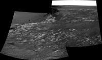
I think too that a move SW is a good one. Half of the bay (C5) is currently hidden behind the tip and if they are still considering it as a possible entry point it would be good to see the whole path down from this side. > I would assume that the name "Valley Without Peril" refers only to bay C5 and not D1. I would consider it as a valley with two entrances, "without" and "with" peril.   Edited: Added this two-frame mosaic of Bay C5.
|
|
|
|
|
|
|
Mar 29 2007, 03:03 PM
Post
#113
|
|||
 Senior Member Group: Members Posts: 4247 Joined: 17-January 05 Member No.: 152 |
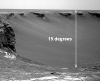
The new images allow us to put some actual constraints on the slopes. From the pre-drive sol 1126 navcam, we can say that the upper reaches of the C5 side of VwP is at around 15 degrees. Totally doable.
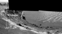
From the 1129 navcam, it's harder to say because we don't have the horizon in the downslope images, but a rough guess, based on Tesheiner's mosaic (did you use 75% reduction?) is 22.5 degrees for the visible portion of the D1 side:
There are small errors in these estimates due to navcam distortions and any non-zero elevation of the apparent horizon. Edit: correcting for actual reduction of 70% (see below) gives 24 degrees for D1. |
||
|
|
|
||
| Guest_Edward Schmitz_* |
Mar 29 2007, 04:20 PM
Post
#114
|
|
Guests |
There would appear to be dark material on the exposed rock in front of the rover. pursumably streak material that has blown out of the crater...
ed |
|
|
|
|
Mar 29 2007, 04:25 PM
Post
#115
|
|
|
Senior Member Group: Moderator Posts: 4279 Joined: 19-April 05 From: .br at .es Member No.: 253 |
> From the 1129 navcam, it's harder to say because we don't have the horizon in the downslope images
The "normal" navcams (including the horizon) are tilted down at 17º while the downlooking ones are tilted at 30º. This might be helpful. > (did you use 75% reduction?) 70% |
|
|
|
|
Mar 29 2007, 05:23 PM
Post
#116
|
|
|
Senior Member Group: Members Posts: 4247 Joined: 17-January 05 Member No.: 152 |
Yeah, that certainly is helpful! 70% instead of 75% reduction means my estimate of the D1 side slope increases to 22.5 degrees * 75/70 = 24.1 degrees.
Taking the centre of the downslope D1 navcam to be -30 degrees elevation, I get a slope of 23.9 degrees. Of course, those decimal points are meaningless, but two distinct methods now give very close to 24 degrees for D1, so I'd be willing to bet that's very close to the truth. |
|
|
|
|
Mar 29 2007, 08:21 PM
Post
#117
|
|
 Member Group: Members Posts: 646 Joined: 23-December 05 From: Forest of Dean Member No.: 617 |
A few things puzzling my weary brain....
-------------------- --
Viva software libre! |
|
|
|
|
Mar 29 2007, 09:19 PM
Post
#118
|
|
|
Member Group: Members Posts: 866 Joined: 15-March 05 From: Santa Cruz, CA Member No.: 196 |
BAD QUOTING REMOVED - STOP IT - Doug
the first streak, which loosk in the Tesheiner's overhead map to be somewhat dark, was never quite as dark as the further one. And if you go back to the SOL 1123 view and then further back to the SOL 1098 view the first streak is relatively unnoticeable from the ground, a mere hint, but the second streak has always had very sharp and dark features. its odd why there is such a disparity from the ground vs the overhead views of the darkness of the first streak, maybe its just at the brightness threshold where it becomes an artifact of camera exposure contrast stretching/compression, but im hoping well get a MI view of the dark streak so we can settle once and for all whos camping out in ground truth: the dust-covered vs dust-cleaned campers. |
|
|
|
|
Mar 29 2007, 10:25 PM
Post
#119
|
|
|
Senior Member Group: Members Posts: 4247 Joined: 17-January 05 Member No.: 152 |
If you look at the MRO orbital imagery, the first dark streak (the one we're sitting on now) is distinctly less dark and has quite a bit fuzzier boundaries than the second streak. Add to that the fact that these are pretty wide features, so you'd expect them to be less noticable when you're sitting on top of them.
If we had a calibrated full 360 navcam mosaic from here I'm sure the streak would be easily noticable. |
|
|
|
|
Mar 30 2007, 09:58 AM
Post
#120
|
||
|
Senior Member Group: Moderator Posts: 4279 Joined: 19-April 05 From: .br at .es Member No.: 253 |
QUOTE (Floyd @ Mar 29 2007, 02:35 PM)  Hope they move southwest to the tip of cape C5 (I guess unnamed as it is between CGH and CSV) to get second set of images. Check these fresh images from sol 1130: http://nasa.exploratorium.edu/mars/opportu...cam/2007-03-30/  Edited: Added a 6x1 navcam mosaic.
|
|
|
|
|
|
|

|
Lo-Fi Version | Time is now: 6th May 2024 - 09:10 AM |
|
RULES AND GUIDELINES Please read the Forum Rules and Guidelines before posting. IMAGE COPYRIGHT |
OPINIONS AND MODERATION Opinions expressed on UnmannedSpaceflight.com are those of the individual posters and do not necessarily reflect the opinions of UnmannedSpaceflight.com or The Planetary Society. The all-volunteer UnmannedSpaceflight.com moderation team is wholly independent of The Planetary Society. The Planetary Society has no influence over decisions made by the UnmannedSpaceflight.com moderators. |
SUPPORT THE FORUM Unmannedspaceflight.com is funded by the Planetary Society. Please consider supporting our work and many other projects by donating to the Society or becoming a member. |
|