The Valley Without Peril (Bay C5), after Cape of Good Hope |

  |
The Valley Without Peril (Bay C5), after Cape of Good Hope |
 Apr 2 2007, 10:01 PM Apr 2 2007, 10:01 PM
Post
#151
|
|
|
Member  Group: Members Posts: 866 Joined: 15-March 05 From: Santa Cruz, CA Member No.: 196 |
QUOTE (MarsIsImportant @ Apr 2 2007, 08:44 AM)  I agree. That's why I don't think the primary source of these streaks is wind related. Wind has only slightly modified them. Those streaks being composed of remnant bedrock (shielded from erosion by the blueberries themselves) as opposed to actual dust collections in the lee tails. so this would suggest were lookng at two different processes here (or maybe three different, if the dark dust inside the crater is different than the dark streaks)I had assumed that the dark streaks were simply dust accumulations from the eroding cliffs, spilling out onto the plains in tails since its denser than the light dust and would of course be deposited in such a pattern, since that explanation looks obvious to my untrained eye from orbit. However, it seem that now that we are pretty sure the streaks are composed of blueberries themselves (or are we?). So this (should) only mean that the blueberries are cleaned by the turbulence exiting the crater, and perhaps the blueberries rinds have even been chemically altered by moisture and/or other minerals spilling up from the crater as well, or perhaps the dark dust has merely 'stuck' to them through this type of process... We shall soon see |
 |
 
|
| Guest_Edward Schmitz_* |
Apr 3 2007, 01:06 AM
Post
#152
|
|
Guests |
At the top of duck bay, there is a dune on the lip of the crater. This suggests to me that the area outside of the bays is a depositional environment. It only makes intuitive sense. The wind would speed up in the bay due to the relative restriction of the bay walls. Once the wind tops the bay, it has the entire planes to spread out again - and slow down.
Another thing... The prevailing winds move from southeast to northwest. But its the northeastern bays that have the streaks. It is also the northeastern bays that have the dark dunes at their base. If the streaks were a cleaning process, shouldn't Bottomless and Bahia Blanca be more efficient cleaners? just my thoughts... |
|
|
|
|
Apr 3 2007, 04:09 PM
Post
#153
|
|
|
Senior Member Group: Moderator Posts: 4279 Joined: 19-April 05 From: .br at .es Member No.: 253 |
Opportunity left the VWP area today (sol 1134).
Navcams: http://qt.exploratorium.edu/mars/opportuni...cam/2007-04-03/ What's not clear to me is if the plan was to investigate the dark streaks *now* or after moving onto Cape St. Vincent. |
|
|
|
|
Apr 3 2007, 04:32 PM
Post
#154
|
|
 Senior Member Group: Members Posts: 4247 Joined: 17-January 05 Member No.: 152 |
I interpreted what we heard as "now". Actually no mention was made of visiting CSV, though it would be out of character to skip a cape. Then again, they are about to head back to Duck Bay.
From the planetary society update: QUOTE "The next step after characterizing the slopes is to drive right into one of those dark streaks that emanate from a couple of these alcoves. ... We will drive into the darkest spot of the darkest dark streak and try to find out what's going on there."
After that, Squyres said the plan for Opportunity is to follow the dark streak back to its source at the rim of the crater, do some work there, then drive out onto the next promontory, named Tierra del Fuego, and take picture of the eastern face of Cape St. Vincent. |
|
|
|
|
Apr 3 2007, 07:41 PM
Post
#155
|
|
 Member Group: Members Posts: 646 Joined: 23-December 05 From: Forest of Dean Member No.: 617 |
QUOTE (fredk @ Apr 2 2007, 04:28 PM) I wrote above that we have dark deposits in the lee of blueberries here. At the bottom of this pancam view we can see sizable collections of dark dust in the lee of some small rocks. Again, doesn't this suggest the darkness is a deposit rather than a removal of light material? Possibly... if similar rocks at other, non-streaky points around the rim don't show the same leeward deposits. I don't recall seeing any, but then I wasn't really looking for them. Also - what about scale? Those small deposits are small and scattered; they would have to be present all over the surface of the dark streaks, ie out on the plain. I imagine the next few sols should clear that up. The case for it being a wind-related phenomena of one sort of another is pretty hard to dispute now, IMO. There's no other evidence for recent water close enough to the surface to affect anything, that I know of; [Edit: apart from the MGS gullies, altered faults and so on, that is  but there's no gullies here, and the fault-line halos are surely long slow processes. These wind streaks have to be caused by something that happens often enough for them to persist through global dust storms, etc., ie. very very recent.) but there's no gullies here, and the fault-line halos are surely long slow processes. These wind streaks have to be caused by something that happens often enough for them to persist through global dust storms, etc., ie. very very recent.)Also, if that were causing the dark streaks, there'd be similar features out on the plains - and there aren't. Either wind is carrying fines out of VC and dropping them where the wind speed drops (ie., in the lee of the rim), or wind coming out of VC is blowing dust off the surface. C'mon JPL/Cornell, open the gold envelope already! -------------------- --
Viva software libre! |
|
|
|
| Guest_Edward Schmitz_* |
Apr 3 2007, 10:02 PM
Post
#156
|
|
Guests |
The streak disappears in the L7 filter. I believe that rules out surface texture as the cause.
|
|
|
|
|
Apr 4 2007, 05:40 AM
Post
#157
|
|
|
Member Group: Members Posts: 184 Joined: 2-March 06 Member No.: 692 |
Just to clarify things for me, we are proposing winds comming generally from the south and scouring or depositing material. So these winds are running parallel to the dunes we (oppy) drove thru. So those dunes must be at the moment fossil dunes, as I wouldn't expect dunes to line up parallel to the wind.
If the wind occasionally shifts to move the dunes, would we see evidence of old streaks? Just what relative ages do we put on these features? Brian |
|
|
|
|
Apr 5 2007, 04:59 AM
Post
#158
|
|
 Senior Member Group: Moderator Posts: 3431 Joined: 11-August 04 From: USA Member No.: 98 |
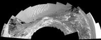
Opportunity Sol 1131 Pancam L2 mosaic, equirectangular projection:
|
|
|
|
|
Apr 5 2007, 06:10 AM
Post
#159
|
||
 Senior Member Group: Members Posts: 2492 Joined: 15-January 05 From: center Italy Member No.: 150 |
Thanks to Michael for equirectangular mosaic...

Attached thumbnail(s)
-------------------- I always think before posting! - Marco -
|
|
|
|
|
|
|
Apr 5 2007, 06:12 PM
Post
#160
|
|
|
Member Group: Members Posts: 910 Joined: 4-September 06 From: Boston Member No.: 1102 |
No images at Exploratorium from either rover for past 27hr. Anyone know if data is showing up elsewhere or if something is up?
-------------------- |
|
|
|
|
Apr 5 2007, 08:02 PM
Post
#161
|
|
|
Founder Group: Chairman Posts: 14432 Joined: 8-February 04 Member No.: 1 |
27 hours and your in a panic already.
 Sol 18A would have put you in an early grave! Spirit - it's 1157.4 now - they have 1156 data on the ground, 1157 is scheduled as a heavy MI workout Oppy - currently 1137.0 - they have plenty of 1136 data on the ground with 1137 not yet scheduled. Doug |
|
|
|
|
Apr 5 2007, 10:13 PM
Post
#162
|
|
|
Member Group: Members Posts: 258 Joined: 22-December 06 Member No.: 1503 |
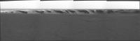
I'm intrigued by this image from Oppy of the Valley Without Peril.
http://qt.exploratorium.edu/mars/opportuni...90P2395L2M1.JPG I'm not sure but--Comparing the MRO overhead images with this one suggests some changes in the mini-dunes of the bay since the MRO one was taken. The critical part is toward the bottom of the new Oppy image; yet it is cut off, so I may be looking at the features wrong. Is what I'm seeing real or am I seeing things? Also, it looks like an ingress here maybe possible afterall. It is just a question of whether they want to enter through a minidune on a slope that might prevent them from getting out again. The dune is so small that I think they might test it with a toe dip. But then again, what is the real advantage of going into Victoria here? |
|
|
|
|
Apr 5 2007, 11:15 PM
Post
#163
|
|||
|
Member Group: Members Posts: 866 Joined: 15-March 05 From: Santa Cruz, CA Member No.: 196 |
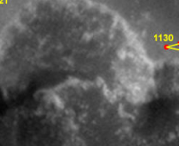
QUOTE (MarsIsImportant @ Apr 5 2007, 02:13 PM) I'm intrigued by this image from Oppy of the Valley Without Peril. that image was from SOL 1131http://qt.exploratorium.edu/mars/opportuni...90P2395L2M1.JPG I'm not sure but--Comparing the MRO overhead images with this one suggests some changes in the mini-dunes of the bay since the MRO one was taken. The critical part is toward the bottom of the new Oppy image; yet it is cut off, so I may be looking at the features wrong. Is what I'm seeing real or am I seeing things? You can pull back an get a broader look from the earlier SOL 1130 so what youre looking for should be in this image, although i dont see much anything out of the ordinary (except for extraordinary and mysterious images of Mars that is), what was it you were trying to point out? the overhead shot detail:
---- On a side note, here is a really good example of where the blueberries appear to have been 'pushed-up' like little terminal moraines around the bedrock plate boundaries has always fascinated me, yet i haven't really heard any explanation of their origin. i would suggest that they have fallen out ofhte bedrock this way as it is eroded, more blueberries fall out and roll down the remaining rock to pile up along its edge and then the edge and its bedrock are gone (to ground level) you end up with little piles like crime scene outlines for each depleted bedrock chunk.
no actually, that would mean that the cracks should be filled in as well, right? ok im lost again. |
||
|
|
|
||
|
Apr 8 2007, 01:31 PM
Post
#164
|
||
|
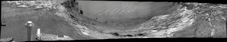
Senior Member Group: Members Posts: 2823 Joined: 22-April 05 From: Ridderkerk, Netherlands Member No.: 353 |
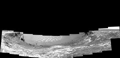
A panoramic view over Victoria Crater.
Taken with the L2 Pancam on Sol 1137. jvandriel
Attached thumbnail(s)
|
|
|
|
|
|
|
Apr 10 2007, 07:24 AM
Post
#165
|
|
 Senior Member Group: Members Posts: 1619 Joined: 12-February 06 From: Bergerac - FR Member No.: 678 |
The Bay "without" peril
-------------------- |
|
|
|
|

|
Lo-Fi Version | Time is now: 6th May 2024 - 04:55 AM |
|
RULES AND GUIDELINES Please read the Forum Rules and Guidelines before posting. IMAGE COPYRIGHT |
OPINIONS AND MODERATION Opinions expressed on UnmannedSpaceflight.com are those of the individual posters and do not necessarily reflect the opinions of UnmannedSpaceflight.com or The Planetary Society. The all-volunteer UnmannedSpaceflight.com moderation team is wholly independent of The Planetary Society. The Planetary Society has no influence over decisions made by the UnmannedSpaceflight.com moderators. |
SUPPORT THE FORUM Unmannedspaceflight.com is funded by the Planetary Society. Please consider supporting our work and many other projects by donating to the Society or becoming a member. |
|