Landing Site Imagery |

  |
Landing Site Imagery |
 Jan 26 2007, 09:03 PM Jan 26 2007, 09:03 PM
Post
#91
|
|
 Administrator  Group: Admin Posts: 5172 Joined: 4-August 05 From: Pasadena, CA, USA, Earth Member No.: 454 |
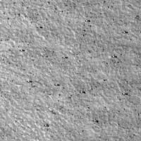
I should probably write that in the caption...anyway, I rarely change the filenames of images as I work with them, so it's still on there in the image in the post. Just save picture as and you'll see it: PSP_001497_2480_RED
I got an interesting email from Mark Lemmon, which I'll blog next week as I've done enough for today, but I thought y'all would enjoy it here: QUOTE I saw your landing site blog entry from yesterday. 8 *meters* is a bit out of our reach ;^). I wanted to note something more subtle. Phoenix will have a controlled landing (we hope), which will align the solar panels roughly E-W. The RA will dig roughly to the north. So, you (or Doug E) shouldn't really randomize the orientation. I asked for more from him on why that orientation -- I'll post Monday.And I did fix that 8-meter mistake (stupid Imperial units...) --Emily -------------------- My website - My Patreon - @elakdawalla on Twitter - Please support unmannedspaceflight.com by donating here.
|
 |
 
|
|
Jan 26 2007, 09:41 PM
Post
#92
|
|
|
Senior Member Group: Members Posts: 2920 Joined: 14-February 06 From: Very close to the Pyrénées Mountains (France) Member No.: 682 |
Emily wrote "which will align the solar panels roughly E-W."
May be I'm too impatient but as I see how important it's for Spirit to get her panel in the right orientation I may be understand why the "slope issue" (of having slopes less than a few degree) is as important as the "boulder issue" -------------------- |
|
|
|
|
Jan 26 2007, 10:04 PM
Post
#93
|
|||
|
Founder Group: Chairman Posts: 14432 Joined: 8-February 04 Member No.: 1 |
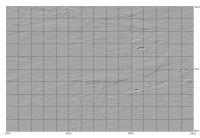
Tried again - 33cm/pixel ( it just seems better at that res ) - with all the landers pointing with arms going north...makes it harder to see with a 30 degree high Sun off to the west - as the shadow falls more under the lander and less onto the ground beside it. Thanks for the pointers Mark
 Doug
Attached thumbnail(s)
|
||
|
|
|
||
|
Jan 26 2007, 10:09 PM
Post
#94
|
|
|
Senior Member Group: Members Posts: 2920 Joined: 14-February 06 From: Very close to the Pyrénées Mountains (France) Member No.: 682 |
QUOTE (djellison @ Jan 26 2007, 11:04 PM)  Tried again - 33cm/pixel ( it just seems better at that res ) - with all the landers pointing with arms going north...makes it harder to see with a 30 degree high Sun off to the west - as the shadow falls more under the lander and less onto the ground beside it. Doug You'd have had real fun on the flight from LA to Dulles with all the JPL's EDL guys playing around altogether to get Phoenix OK on the ground 
-------------------- |
|
|
|
|
Mar 14 2007, 02:41 AM
Post
#95
|
|
|
Solar System Cartographer Group: Members Posts: 10153 Joined: 5-April 05 From: Canada Member No.: 227 |
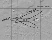
Landing site update from Peter Smith's LPSC poster. Of the three boxes considered in Regions D and A, Box 1 has been selected as the final 'box' (2.5 degrees north to south, 9 degrees east-west, which is about 150 km square). This is in the 'green valley' area, about 80 km west of a 10 km crater on the south edge of the valley. The ellipse can still move around a bit within the box.
Phil -------------------- ... because the Solar System ain't gonna map itself.
Also to be found posting similar content on https://mastodon.social/@PhilStooke Maps for download (free PD: https://upload.wikimedia.org/wikipedia/comm...Cartography.pdf NOTE: everything created by me which I post on UMSF is considered to be in the public domain (NOT CC, public domain) |
|
|
|
|
Mar 14 2007, 05:32 AM
Post
#96
|
|
 Member Group: Members Posts: 540 Joined: 25-October 05 From: California Member No.: 535 |
Cool. Nice to know Phoenix's future home on the Red Planet has been selected
http://www.nature.com/news/2007/070312/full/070312-5.html -------------------- 2011 JPL Tweetup photos: http://www.rich-parno.com/aa_jpltweetup.html
http://human-spaceflight.blogspot.com |
|
|
|
|
Apr 6 2007, 02:10 PM
Post
#97
|
|||
|
Solar System Cartographer Group: Members Posts: 10153 Joined: 5-April 05 From: Canada Member No.: 227 |
Update from LPSC on the Phoenix site.
This is the region of the landing site:
and this is the site itself with three landing ellipses oriented according to different arrival dates. The intersection of the ellipses is the preferred location.
Phil -------------------- ... because the Solar System ain't gonna map itself.
Also to be found posting similar content on https://mastodon.social/@PhilStooke Maps for download (free PD: https://upload.wikimedia.org/wikipedia/comm...Cartography.pdf NOTE: everything created by me which I post on UMSF is considered to be in the public domain (NOT CC, public domain) |
||
|
|
|
||
|
Apr 6 2007, 05:04 PM
Post
#98
|
|
|
Member Group: Members Posts: 252 Joined: 5-May 05 From: Mississippi (USA) Member No.: 379 |
QUOTE (Phil Stooke @ Apr 6 2007, 10:10 AM) Update from LPSC on the Phoenix site. This is the region of the landing site: I am on dial-up. I will not be downloading any Hirise size files, so I saved your graphics to a newly created Phoenix directory. Good basic material for following the future mission. However I have one question - Edit Forget the question. It can be answered by comparing both images.  Original question Is the geometry of that image accurate? All the craters are extremely squashed ovals - wildly stretched east and west. Is it caused by projecting parallel longitude lines? . |
|
|
|
|
Apr 6 2007, 05:27 PM
Post
#99
|
|
|
Administrator Group: Admin Posts: 5172 Joined: 4-August 05 From: Pasadena, CA, USA, Earth Member No.: 454 |
Yes, the first one is a simple cylindrical projection, which is why everything is so stretched out in longitude. 1 degree of longitude does not equal one degree of latitude this far north, not even close! Map projections are actually a real problem for this mission. Phil, of course, would be the correct authority on what projection they SHOULD be using for their maps...
Phil, where did you find that update? I couldn't find it on the Phoenix site. Can you post a link? --Emily -------------------- My website - My Patreon - @elakdawalla on Twitter - Please support unmannedspaceflight.com by donating here.
|
|
|
|
|
Apr 6 2007, 05:28 PM
Post
#100
|
|
|
Solar System Cartographer Group: Members Posts: 10153 Joined: 5-April 05 From: Canada Member No.: 227 |
The geometry is perfectly accurate - for that map projection. Simple Cylindrical does that to craters. The second image is part of the same thing, but stretched vertically to give a better idea of shape.
Emily - a polar sterographic or a conic projection at that latitude would be better for shape. I used the Simple Cylindrical because that's how we can now get all this good stuff straight off the Themis site: http://jmars.asu.edu/data/ As for the update... Ah, Em, you shoulda been there! I took it from Peter Smith's LPSC talk and poster. Phil -------------------- ... because the Solar System ain't gonna map itself.
Also to be found posting similar content on https://mastodon.social/@PhilStooke Maps for download (free PD: https://upload.wikimedia.org/wikipedia/comm...Cartography.pdf NOTE: everything created by me which I post on UMSF is considered to be in the public domain (NOT CC, public domain) |
|
|
|
|
Apr 24 2007, 09:14 PM
Post
#101
|
|
|
Member Group: Members Posts: 428 Joined: 21-August 06 From: Northern Virginia Member No.: 1062 |
An interesting article on undergraduate labor. http://www.spaceref.com/news/viewpr.nl.html?pid=22456
|
|
|
|
|
Jul 30 2007, 11:41 PM
Post
#102
|
|
|
Member Group: Members Posts: 540 Joined: 17-November 05 From: Oklahoma Member No.: 557 |
I may have missed it somewhere else, but I've never heard whether MRO concluded it's HiRes imaging campaign of the entire Phoenix landing site. Did it finish? If not, is The Storm having any effect on it's imaging at this latitude?
I know the days have to be getting short at the site by this time of (martian) year. So if they're not done yet ... |
|
|
|
|
Aug 4 2007, 08:31 PM
Post
#103
|
|
|
Solar System Cartographer Group: Members Posts: 10153 Joined: 5-April 05 From: Canada Member No.: 227 |
Phil reporting in from an internet cafe in Tofino, BC:
No, I don't think there is very much coverage yet. New pics will be taken after the sun gets higher again, not too long before landing. Phil -------------------- ... because the Solar System ain't gonna map itself.
Also to be found posting similar content on https://mastodon.social/@PhilStooke Maps for download (free PD: https://upload.wikimedia.org/wikipedia/comm...Cartography.pdf NOTE: everything created by me which I post on UMSF is considered to be in the public domain (NOT CC, public domain) |
|
|
|
|
Aug 4 2007, 08:44 PM
Post
#104
|
|
 Special Cookie Group: Members Posts: 2168 Joined: 6-April 05 From: Sintra | Portugal Member No.: 228 |
BAD QUOTING - STOP IT
That will feed our eager minds untill May... Advanced discovery planning, we're into it... 
-------------------- "Ride, boldly ride," The shade replied, "If you seek for Eldorado!"
Edgar Alan Poe |
|
|
|
|
Aug 6 2007, 02:11 AM
Post
#105
|
|
 Member Group: Members Posts: 290 Joined: 29-December 05 From: Ottawa, ON Member No.: 624 |
QUOTE (Phil Stooke @ Aug 4 2007, 01:31 PM) Phil reporting in from an internet cafe in Tofino, BC: No, I don't think there is very much coverage yet. New pics will be taken after the sun gets higher again, not too long before landing. Phil FYI, Phil, There is a bakery there that has the best Pizza I've ever tasted, that and it's the hotbed of Sasquatch sightings. |
|
|
|
|

|
Lo-Fi Version | Time is now: 27th April 2024 - 09:34 PM |
|
RULES AND GUIDELINES Please read the Forum Rules and Guidelines before posting. IMAGE COPYRIGHT |
OPINIONS AND MODERATION Opinions expressed on UnmannedSpaceflight.com are those of the individual posters and do not necessarily reflect the opinions of UnmannedSpaceflight.com or The Planetary Society. The all-volunteer UnmannedSpaceflight.com moderation team is wholly independent of The Planetary Society. The Planetary Society has no influence over decisions made by the UnmannedSpaceflight.com moderators. |
SUPPORT THE FORUM Unmannedspaceflight.com is funded by the Planetary Society. Please consider supporting our work and many other projects by donating to the Society or becoming a member. |
|