First public release of Kaguya data |

  |
First public release of Kaguya data |
 Nov 2 2009, 05:07 AM Nov 2 2009, 05:07 AM
Post
#1
|
|
 Administrator  Group: Admin Posts: 5172 Joined: 4-August 05 From: Pasadena, CA, USA, Earth Member No.: 454 |
I just received the following from Shin-ichi Sobue at JAXA:
QUOTE The Japan Aerospace Exploration Agency (JAXA) released data from the lunar explorer "KAGUYA" (SELENE) (L2 products) during the nominal operation phase (from December 21, 2007 to October 31, 2008) to the public through the Internet. I wish I could post some images but I'm having a bit of trouble with the Data Archive website -- got registered OK, but my searches seem to return database errors. And I couldn't seem to find my way to Terrain Camera data. Perhaps it's because my brain is somewhat mushy from a day of football and beer L2 products are calibrated/validated processed data from KAGUYA science mission instruments. By using the L2 products, researchers all over the world are expected to advance the scientific analysis and applicability investigation of the Moon. "KAGUYA 3D Moon NAVI" services, which can show KAGUYA data using a three-dimension geographic information system (WebGIS) through the Internet, have also commenced. The developed software is based on NASA "World Wind" and the KAGUYA's images and data can be displayed using the 3D map projection function. It is necessary to download and install the free software. Please refer to the following homepage for details. L2 products during the extended operational phase (until June 2009) are scheduled to be released after processing and calibration/validation are finished. 【KAGUYA(SELENE) Data Archive】 http://www.soac.selene.isas.jaxa.jp/ 【KAGUYA 3D Moon NAVI】 http://wms.selene.jaxa.jp/3dmoon/index.html  But I give up for the night and give you guys the link in the hopes you can figure out how to get pretty pictures out of this website! But I give up for the night and give you guys the link in the hopes you can figure out how to get pretty pictures out of this website!I've attached the whole doc that Shin-ichi sent me, which contains a little more info about the data sets in the release. --Emily
Attached File(s)
-------------------- My website - My Patreon - @elakdawalla on Twitter - Please support unmannedspaceflight.com by donating here.
|
 |
 
|
|
Nov 2 2009, 08:16 AM
Post
#2
|
|
|
Founder Group: Chairman Posts: 14433 Joined: 8-February 04 Member No.: 1 |
First thing I wanted was TOPO data - and managed to get through registration, data search - all worked. Got my email with an FTP link for the 400 meg data file.
Download 4kb/sec. I'll try again later - I wonder if it'll be mirrored by the PDS themselves. (100 - 150kb/sec now) |
|
|
|
|
Nov 2 2009, 10:51 AM
Post
#3
|
|
|
Member Group: Members Posts: 470 Joined: 24-March 04 From: Finland Member No.: 63 |
Are they going to release the actual HD camera data?
-------------------- Antti Kuosmanen
|
|
|
|
|
Nov 2 2009, 11:44 AM
Post
#4
|
|
|
Founder Group: Chairman Posts: 14433 Joined: 8-February 04 Member No.: 1 |
That's copyrighted by the broadcast company that built the camera I believe - so no. The release specifically states
QUOTE The position and time of movie images (only catalog information. HDTV movies can be seen on the JAXA digital archives and YouTube site I managed to buy an import of the blu-ray disk they did and it's worth it for the 15 or so minutes that's included, but they've taken hours and hours of footage since then. The question for me is - what to do with a .sl2 file. |
|
|
|
|
Nov 2 2009, 02:32 PM
Post
#5
|
|
|
Solar System Cartographer Group: Members Posts: 10186 Joined: 5-April 05 From: Canada Member No.: 227 |
I'm registered but I haven't figured it out yet - trying to get TC images or orthomaps in a given area, I search successfully but get 'no data'.
Terrain Camera data as far as I understand it comes in the LISM dataset. Phil -------------------- ... because the Solar System ain't gonna map itself.
Also to be found posting similar content on https://mastodon.social/@PhilStooke Maps for download (free PD: https://upload.wikimedia.org/wikipedia/comm...Cartography.pdf NOTE: everything created by me which I post on UMSF is considered to be in the public domain (NOT CC, public domain) |
|
|
|
|
Nov 2 2009, 02:54 PM
Post
#6
|
|
|
Solar System Cartographer Group: Members Posts: 10186 Joined: 5-April 05 From: Canada Member No.: 227 |
OK, getting somewhere... if you run the 3D Moon Java app you can view datasets on a globe, and rotate it to view any region. Works great for the altimetry, GRS, magnetometer etc. Then I display TC on that - just a few spots. Tycho is one, Mare Moscoviense another. So back to the database search. Select LISM datasets, search on Tycho coordinates, then choose TC orthomap, and bingo, lots of datasets.
Presumably the database will be populated with other TC scenes later. Phil EDIT: I've ordered a TC map scene (2 degrees by 2 degrees, on N rim of TYcho, Surveyor 7 area... I'll be able to FTP it soon. We'll see what we get. Phil -------------------- ... because the Solar System ain't gonna map itself.
Also to be found posting similar content on https://mastodon.social/@PhilStooke Maps for download (free PD: https://upload.wikimedia.org/wikipedia/comm...Cartography.pdf NOTE: everything created by me which I post on UMSF is considered to be in the public domain (NOT CC, public domain) |
|
|
|
|
Nov 2 2009, 09:12 PM
Post
#7
|
|
 Senior Member Group: Moderator Posts: 3431 Joined: 11-August 04 From: USA Member No.: 98 |
I'm downloading the elevation data (at least I hope it's the right file - LALT_GGT_NUM.sl2). Should be interesting...
|
|
|
|
|
Nov 2 2009, 10:50 PM
Post
#8
|
|
|
Solar System Cartographer Group: Members Posts: 10186 Joined: 5-April 05 From: Canada Member No.: 227 |
--- still struggling with the format. My image appears to be a 8192 x 8192 pixel 32 bit image. So far nothing is opening it. Any suggestions (I mean from somebody who has successfully opened one!)
Edit: Oh poop! I didn't see this before. Should have done my homework first: About ".sl2"file format The form of the file compresses tar. Please uncompresses and use. (example) tar xvf dddd.sl2 dddd.sl2 : Acquisition file name Phil -------------------- ... because the Solar System ain't gonna map itself.
Also to be found posting similar content on https://mastodon.social/@PhilStooke Maps for download (free PD: https://upload.wikimedia.org/wikipedia/comm...Cartography.pdf NOTE: everything created by me which I post on UMSF is considered to be in the public domain (NOT CC, public domain) |
|
|
|
|
Nov 2 2009, 11:09 PM
Post
#9
|
|
|
Administrator Group: Admin Posts: 5172 Joined: 4-August 05 From: Pasadena, CA, USA, Earth Member No.: 454 |
I'm glad you're slogging through this and not me!
 Via Twitter it seems Mike Howard's been having some success with the topographic data. -------------------- My website - My Patreon - @elakdawalla on Twitter - Please support unmannedspaceflight.com by donating here.
|
|
|
|
|
Nov 2 2009, 11:24 PM
Post
#10
|
|
|
Founder Group: Chairman Posts: 14433 Joined: 8-February 04 Member No.: 1 |
Well - I managed to look at the resulting file - after a header it's lat, long, alt
I don't have anything I know of that can turn that into something usefull for me, such as a high bit png/tiff/tga etc etc. |
|
|
|
|
Nov 2 2009, 11:49 PM
Post
#11
|
|
|
Senior Member Group: Moderator Posts: 3431 Joined: 11-August 04 From: USA Member No.: 98 |
QUOTE (djellison @ Nov 2 2009, 04:24 PM)  I don't have anything I know of that can turn that into something usefull for me, such as a high bit png/tiff/tga etc etc. I'm on it. If my cats will leave me alone for awhile. It's 5760x2880 floating point values. What format would you ideally like? |
|
|
|
|
Nov 2 2009, 11:57 PM
Post
#12
|
|
|
Senior Member Group: Moderator Posts: 3431 Joined: 11-August 04 From: USA Member No.: 98 |
P.S. For the images - I haven't looked at those, but the elevation data has PDS headers, I wonder if the images do too. Maybe IMG2PNG could be adapted? I'd volunteer, but I don't do Windows, or scripting languages. (Actually I think IMG2PNG is an .exe, IIRC.)
|
|
|
|
|
Nov 3 2009, 12:09 AM
Post
#13
|
|
|
Member Group: Members Posts: 890 Joined: 18-November 08 Member No.: 4489 |
finally i can get ride of my "artists concept " topo map . that will be wroth while .
|
|
|
|
|
Nov 3 2009, 12:17 AM
Post
#14
|
|
|
Senior Member Group: Moderator Posts: 3431 Joined: 11-August 04 From: USA Member No.: 98 |
I'm going to have to go out to dinner pretty soon, but I should be able to produce a 5760x2880 bump map PNG, normal map PNG, and binary stream of floats within the next 24 hours, assuming the data is good. Unless somebody else can do it faster.
|
|
|
|
|
Nov 3 2009, 01:22 AM
Post
#15
|
|
 IMG to PNG GOD Group: Moderator Posts: 2251 Joined: 19-February 04 From: Near fire and ice Member No.: 38 |
QUOTE (mhoward @ Nov 2 2009, 11:57 PM) P.S. For the images - I haven't looked at those, but the elevation data has PDS headers, I wonder if the images do too. Maybe IMG2PNG could be adapted? I'd volunteer, but I don't do Windows, or scripting languages. (Actually I think IMG2PNG is an .exe, IIRC.) If these files have PDS headers followed by floating point data IMG2PNG might already be able to read them. If not, modifying it to do so is trivial for me - the most complex step is probably getting the data so I can test it ;-). Can't do it until about 20 hours from now though. I have been waiting more than 10 years (!) for a nice, global DEM of the Moon so this is something that really interests me. |
|
|
|
|
Nov 3 2009, 01:50 AM
Post
#16
|
|
|
Solar System Cartographer Group: Members Posts: 10186 Joined: 5-April 05 From: Canada Member No.: 227 |
IMG2PNG can't do it as it is. The problem might be the header, but I'm not sure. A solution along these lines would be great. Any unzip-type app will extract the IMG file from the downloaded file, but I can't get anything else to open the IMG.
Phil -------------------- ... because the Solar System ain't gonna map itself.
Also to be found posting similar content on https://mastodon.social/@PhilStooke Maps for download (free PD: https://upload.wikimedia.org/wikipedia/comm...Cartography.pdf NOTE: everything created by me which I post on UMSF is considered to be in the public domain (NOT CC, public domain) |
|
|
|
|
Nov 3 2009, 08:57 AM
Post
#17
|
|
|
Founder Group: Chairman Posts: 14433 Joined: 8-February 04 Member No.: 1 |
The best analogy I can come up with is the values in HRSC Dems - which a guy on HRSC kindly wrote an IDL routine to churn into something usefull
QUOTE hrsc2tif A tool to convert HRSC PDS- or VICAR-format files to TIFF format. For DTMs, the 16-bit signed integers are converted to 16-bit unsigned integers by adding 32768. Limitation: only converts files small enough to be read into RAM. The software requires installation of the free IDL virtual machine, and runs on all common platforms. This data set is in km if i remember, so it would need to be multiplied by 1000 first - than then have the negative value of the lowest negative altitude added (i.e. if the lowest is -1580 metres, add 1580 to make them all positive values starting at 0) To be honest, just a raw array of values normally can be convinced to work with ImageJ or Photoshop. |
|
|
|
|
Nov 3 2009, 09:32 AM
Post
#18
|
|
|
Member Group: Members Posts: 890 Joined: 18-November 08 Member No.: 4489 |
i just looked at LALT_GGT_NUM.TAB in ghex edit
see screen shot [attachment=19510:Screenshot.png] on the right -- the 3 columns top one CODE 89.96875 0.040 0.09375 is looking like excel is going to get puled out i will need to pull the middle value first is lat. second is the gray value and the third is the long. |
|
|
|
|
Nov 3 2009, 10:25 AM
Post
#19
|
|
|
Founder Group: Chairman Posts: 14433 Joined: 8-February 04 Member No.: 1 |
As text loaded straight into ImageJ - it's lat long alt - there's a header that describes it once unzipped (I used 7zip) - you may have it muddled somewhere.
|
|
|
|
|
Nov 3 2009, 06:48 PM
Post
#20
|
||
|
Founder Group: Chairman Posts: 14433 Joined: 8-February 04 Member No.: 1 |
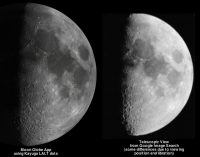
Thanks to mhoward's processing and my running it through ImageJ - we have a 16bit Tif for those that like such things. It looks like the attached 1/4 size JPG and is found HERE - About 26 meg
Attached thumbnail(s)
|
|
|
|
|
|
|
Nov 3 2009, 07:05 PM
Post
#21
|
||
|
Senior Member Group: Moderator Posts: 3431 Joined: 11-August 04 From: USA Member No.: 98 |
Also, something we've been waiting for for a long time: a proper surface normal map for the Moon.
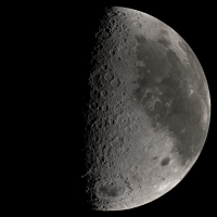
LALT surface normal map (22MB PNG) enhanced LALT surface normal map (26MB PNG) The first version is technically accurate AFAIK; the second is "enhanced" a bit (the normal vector x and y are magnified somewhat). Use whichever one works best. Attached is a quarter-sized version of the enhanced model.
Attached thumbnail(s)
|
|
|
|
|
|
|
Nov 3 2009, 07:09 PM
Post
#22
|
|||||
 Senior Member Group: Moderator Posts: 3233 Joined: 11-February 04 From: Tucson, AZ Member No.: 23 |
These Celestia screenshots use mhoward's regular normal map:
-------------------- &@^^!% Jim! I'm a geologist, not a physicist!
The Gish Bar Times - A Blog all about Jupiter's Moon Io |
||||
|
|
|
||||
|
Nov 3 2009, 07:24 PM
Post
#23
|
||
|
Senior Member Group: Moderator Posts: 3431 Joined: 11-August 04 From: USA Member No.: 98 |
My cellphone probably can't compete with stuff rendered on a full-blown computer, but an experimental version of my Moon Globe app looks better using this data, too.
Attached thumbnail(s)
|
|
|
|
|
|
|
Nov 3 2009, 07:27 PM
Post
#24
|
|
|
Member Group: Members Posts: 890 Joined: 18-November 08 Member No.: 4489 |
for celestia you might want to run the 16bit tiff through nms to make a spherical corrected normal map
|
|
|
|
|
Nov 3 2009, 07:39 PM
Post
#25
|
|
|
Senior Member Group: Moderator Posts: 3431 Joined: 11-August 04 From: USA Member No.: 98 |
QUOTE (JohnVV @ Nov 3 2009, 12:27 PM) for celestia you might want to run the 16bit tiff through nms to make a spherical corrected normal map If somebody does that, I'd be curious to know if the result is different from mine. I'm glad to know about those tools, but I don't have time to look into them further now. |
|
|
|
|
Nov 3 2009, 07:44 PM
Post
#26
|
|
|
Senior Member Group: Moderator Posts: 3431 Joined: 11-August 04 From: USA Member No.: 98 |
P.S. If anybody prefers raw 16-bit binary integer data over the 16-bit TIFF file, I've got that - just
|
|
|
|
|
Nov 3 2009, 07:48 PM
Post
#27
|
|
|
Junior Member Group: Members Posts: 35 Joined: 28-September 05 From: Seattle, WA Member No.: 514 |
QUOTE (mhoward @ Nov 3 2009, 11:39 AM) If somebody does that, I'd be curious to know if the result is different from mine. I'm glad to know about those tools, but I don't have time to look into them further now. nms (Normal Map Spherical) just applies a correction for the spherical geometry of a planet. The slope in x is increased by a factor of (1/cos(latitude)) to account for the fact that the map is horizontally compressed near the poles. If you wrote a tool especially to make normal maps for planets, it may already be doing this. If not, it's an easy correction to include. --Chris |
|
|
|
|
Nov 3 2009, 07:50 PM
Post
#28
|
|
|
Junior Member Group: Members Posts: 35 Joined: 28-September 05 From: Seattle, WA Member No.: 514 |
QUOTE (djellison @ Nov 3 2009, 10:48 AM) Thanks to mhoward's processing and my running it through ImageJ - we have a 16bit Tif for those that like such things. Thanks for producing this! What heights to the minimum and maximum pixel values represent in this tiff? EDIT: Probably a dumb question. After opening the zip, I see that the pixel units are apparently meters. --Chris |
|
|
|
|
Nov 3 2009, 07:56 PM
Post
#29
|
|
|
Senior Member Group: Moderator Posts: 3431 Joined: 11-August 04 From: USA Member No.: 98 |
Thanks, Chris. I've got the sine of the latitude in my math, so I think I'm doing the same thing, maybe in a slightly different way. Still would be curious to know if the result comes out exactly the same.
|
|
|
|
|
Nov 3 2009, 09:25 PM
Post
#30
|
|
|
Senior Member Group: Moderator Posts: 3233 Joined: 11-February 04 From: Tucson, AZ Member No.: 23 |
-------------------- &@^^!% Jim! I'm a geologist, not a physicist!
The Gish Bar Times - A Blog all about Jupiter's Moon Io |
|
|
|
|
Nov 3 2009, 09:48 PM
Post
#31
|
|
|
Senior Member Group: Moderator Posts: 3431 Joined: 11-August 04 From: USA Member No.: 98 |
Awesome movie.
Now that I'm working with the normal map, I notice it's pretty rough around the poles. I'm working on smoothing it out. |
|
|
|
|
Nov 3 2009, 11:43 PM
Post
#32
|
|||||
|
IMG to PNG GOD Group: Moderator Posts: 2251 Joined: 19-February 04 From: Near fire and ice Member No.: 38 |
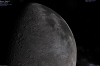
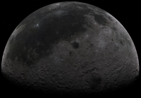
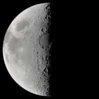
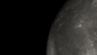
Having this DEM is awesome, for the first time I'm able to get lunar renders I'm happy with. Here is a test render. The data is rendered as a DEM (not a normal or bump map) meaning it is possible to spot some slight irregularities (mountains etc.) on the limb, especially in the south. It is rendered using data from the 16 bit integer file created by mhoward and shows the Moon as it might look as seen from the Earth:
And here's another one showing the Moon from a distance of 4000 km from the Moon's center. The field of view is 35 degrees:
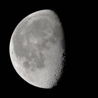
At this close range it would be nice to have a slightly higher resolution DEM although this is not a major issue. Another one, this time 6100 km from the Moon's center, FOV 35 degrees. The "subspacecraft" point is lat=-10, lon=270 degrees west. This is probably my best one so far:
Yet another one, this time from an altitude of 300 km and with a FOV of 45 degrees. This one is intended to show the limitations of the DEM, i.e. insufficient resolution for closeups like this one. It will be fun to do again in the future once the higher resolution LRO data arrives.
This is a lovely dataset to play with. |
||||
|
|
|
||||
|
Nov 4 2009, 01:58 AM
Post
#33
|
|
|
Solar System Cartographer Group: Members Posts: 10186 Joined: 5-April 05 From: Canada Member No.: 227 |
Outstanding! The DEM is indeed a wonderful product. I'm a bit concerned right now with what seems to be a very limited release of TC data. As far as I can see it is indeed limited to the small areas visible in the 3DMoon global viewer, but I assume more will be added soon.
One wee problem in 3DMoon - check out the RSAT gravity data - you can plot the Clementine or topography data first, then overlay an RSAT dataset, and flick it on and off to see how it lines up with topography... but it doesn't! They have accidentally flipped it 180 degrees in longitude. I expect it will be fixed soon. Phil -------------------- ... because the Solar System ain't gonna map itself.
Also to be found posting similar content on https://mastodon.social/@PhilStooke Maps for download (free PD: https://upload.wikimedia.org/wikipedia/comm...Cartography.pdf NOTE: everything created by me which I post on UMSF is considered to be in the public domain (NOT CC, public domain) |
|
|
|
|
Nov 4 2009, 02:20 AM
Post
#34
|
|
|
Junior Member Group: Members Posts: 35 Joined: 28-September 05 From: Seattle, WA Member No.: 514 |
QUOTE (mhoward @ Nov 3 2009, 01:48 PM) Now that I'm working with the normal map, I notice it's pretty rough around the poles. I'm working on smoothing it out. I processed with the 16-bit height data with the nms tool, and I get a normal map that's rougher around the poles. You must be capping the spherical correction factor to some maximum value? My normal map is almost identical to yours except within a couple degrees of the poles. It sure does seems like the polar regions need some filtering--artifacts are apparent near the poles even when slopes aren't amplified by the spherical correction factor. --Chris |
|
|
|
|
Nov 4 2009, 02:44 AM
Post
#35
|
|
|
Member Group: Members Posts: 890 Joined: 18-November 08 Member No.: 4489 |
i just made a normal with my hacked copy of nms ( mine uses unsigned 16 bit)
the zip is a png image using my default settings and the default 16 bit tiff from above 5670x2880.png http://www.zshare.net/download/6793328103b3d90b/ a 1024x512.png image [attachment=19509:1k.png] |
|
|
|
|
Nov 4 2009, 03:58 AM
Post
#36
|
|
|
Member Group: Members Posts: 890 Joined: 18-November 08 Member No.: 4489 |
two screen shots
the first one is the NEW one at default settings and the second is my OLD hand drawn height map [attachment=19511:moon_new.jpg] [attachment=19512:moon_old.jpg] |
|
|
|
|
Nov 4 2009, 03:59 AM
Post
#37
|
|
|
Solar System Cartographer Group: Members Posts: 10186 Joined: 5-April 05 From: Canada Member No.: 227 |
"probably my best so far" - yes, I'd say that deserves to be a Lunar Picture of the Day...
Phil -------------------- ... because the Solar System ain't gonna map itself.
Also to be found posting similar content on https://mastodon.social/@PhilStooke Maps for download (free PD: https://upload.wikimedia.org/wikipedia/comm...Cartography.pdf NOTE: everything created by me which I post on UMSF is considered to be in the public domain (NOT CC, public domain) |
|
|
|
|
Nov 4 2009, 06:26 AM
Post
#38
|
|
 The Poet Dude Group: Moderator Posts: 5551 Joined: 15-March 04 From: Kendal, Cumbria, UK Member No.: 60 |
Bjorn - absolutely stunning pics, thank you!
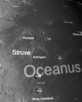
Do you take requests? I could really do with a couple of nice pics of the crater "Eddington", for obvious reasons... 
-------------------- |
|
|
|
|
Nov 4 2009, 09:07 AM
Post
#39
|
|
|
Newbie Group: Members Posts: 3 Joined: 10-June 09 Member No.: 4816 |
Bjor (and JohnVV!) amazing work! Seeing oblique Mare Crisium on the west as seen from Earth on the east! Amazing! Langrenus and Humboldt as round craters! Something you can't see from down here
|
|
|
|
|
Nov 4 2009, 11:50 AM
Post
#40
|
|||
 Senior Member Group: Members Posts: 3648 Joined: 1-October 05 From: Croatia Member No.: 523 |
Outstanding work, Bjorn!
 This may be the first time a computer render I've seen be so realistic - in fact with a bit of fiddling around in Photoshop (I assume you didn't do the 2.2 gamma correction judging by contrast?) you could pass it along as a photograph to unsuspecting folks.
-------------------- |
||
|
|
|
||
|
Nov 4 2009, 03:05 PM
Post
#41
|
|
|
Member Group: Members Posts: 378 Joined: 21-April 05 From: Portugal Member No.: 347 |
It does look quite photographic
! Congratulations for all the nice renders on this thread.
-------------------- _______________________
www.astrosurf.com/nunes |
|
|
|
|
Nov 4 2009, 04:12 PM
Post
#42
|
|
|
Senior Member Group: Moderator Posts: 3431 Joined: 11-August 04 From: USA Member No.: 98 |
QUOTE (claurel @ Nov 3 2009, 07:20 PM) You must be capping the spherical correction factor to some maximum value? Yes - you are right. I think I was doing that for some reason when processing the MOLA data. (In my case it's a minimum value - apparently I've done mine differently somehow, but it's equivalent.) QUOTE (claurel @ Nov 3 2009, 07:20 PM) It sure does seem like the polar regions need some filtering--artifacts are apparent near the poles even when slopes aren't amplified by the spherical correction factor. Indeed. I've got a somewhat smoothed out version now that I'll post for people to use if they want to: LALT_normalmapV2.png (21.5MB PNG) Others may be able to do a better job filtering it; this is sufficient for my purposes. |
|
|
|
|
Nov 4 2009, 04:21 PM
Post
#43
|
||
|
Senior Member Group: Moderator Posts: 3431 Joined: 11-August 04 From: USA Member No.: 98 |
After adding the LALT normal map, I've been tweaking the lighting parameters in Moon Globe to try to make it look more realistic (something I've already spent a lot of time doing - it's not easy to get this to work on a first-generation iPhone). Here's a quick comparison:
Attached thumbnail(s)
|
|
|
|
|
|
|
Nov 5 2009, 12:00 AM
Post
#44
|
||
|
IMG to PNG GOD Group: Moderator Posts: 2251 Joined: 19-February 04 From: Near fire and ice Member No.: 38 |
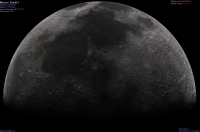
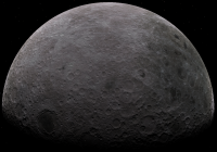
QUOTE (ugordan @ Nov 4 2009, 11:50 AM) Outstanding work, Bjorn! This may be the first time a computer render I've seen be so realistic - in fact with a bit of fiddling around in Photoshop (I assume you didn't do the 2.2 gamma correction judging by contrast?) you could pass it along as a photograph to unsuspecting folks. Yes, these are probably the most realistic renders I have ever done. And as you suspected there's no 2.2 gamma correction - your versions are even more realistic. QUOTE (Stu @ Nov 4 2009, 06:26 AM) Bjorn - absolutely stunning pics, thank you! Do you take requests? I could really do with a couple of nice pics of the crater "Eddington", for obvious reasons... Normally not but here's a quick and dirty render with Eddington visible. The "subspacecraft" point is 22°N, 95°W, the distance from the Moon's center is 6100 km and the FOV is 35°. The subsolar longitude is 15°W.
I should probably make a rotation movie of this thing... |
|
|
|
|
|
|
Nov 5 2009, 01:43 AM
Post
#45
|
|
|
Merciless Robot Group: Admin Posts: 8784 Joined: 8-December 05 From: Los Angeles Member No.: 602 |
Quick, oh yes, but dirty....?
 Stunning. Stunning.
-------------------- A few will take this knowledge and use this power of a dream realized as a force for change, an impetus for further discovery to make less ancient dreams real.
|
|
|
|
|
Nov 5 2009, 05:27 AM
Post
#46
|
|
|
Senior Member Group: Moderator Posts: 3431 Joined: 11-August 04 From: USA Member No.: 98 |
That's extraordinary, Bjorn.
Earlier today I updated the second version of my normal map (link above), to smooth over a few spots where there are glitches in the source data. |
|
|
|
|
Nov 5 2009, 09:18 PM
Post
#47
|
||||||
|
Founder Group: Chairman Posts: 14433 Joined: 8-February 04 Member No.: 1 |
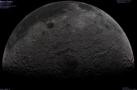
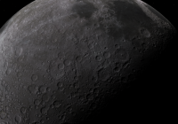
Finally figured out self shadowing terrain that I've been struggling with for a while... a couple of what I THINK are realistic renders, plus one with UBER-EXAGER-TERRAIN and a final one that's exagerated, but only to look a bit more realistic. It seems I have to turn up above and beyond what I'd expect the numbers to require for realistic terrain - perhaps because of the comparatively low level of detail in the terrain models.
And because the resolution isn't that good - a bit of foreshortening to get a look at Eddington for Stu
Attached thumbnail(s)
|
|||||
|
|
|
|||||
|
Nov 5 2009, 10:11 PM
Post
#48
|
|
|
The Poet Dude Group: Moderator Posts: 5551 Joined: 15-March 04 From: Kendal, Cumbria, UK Member No.: 60 |
These Kaguya-derived images are absolutely stunning, great work everyone. This actually feels like a planetary encounter, with new images of a new world for us all to drool over...
And thanks for the Eddington pic Doug, much appreciated. I've some big talks coming up before Christmas and really want to be able to show off that crater, for obvious reasons :-) -------------------- |
|
|
|
|
Nov 5 2009, 10:23 PM
Post
#49
|
|
 Senior Member Group: Admin Posts: 4763 Joined: 15-March 05 From: Glendale, AZ Member No.: 197 |
I like the exaggerated one. Somehow on a globe it doesn't seem to be terribly out of place. I think it's useful for understanding the terrain and relative elevations and crater depths.
-------------------- If Occam had heard my theory, things would be very different now.
|
|
|
|
|
Nov 6 2009, 12:41 PM
Post
#50
|
|
|
Junior Member Group: Members Posts: 94 Joined: 15-October 09 Member No.: 4979 |
I wonder when we'll see the first program that accurately renders this topographical data so we can really plan our lunar observations...
Excellent renders, everyone! |
|
|
|
|
Nov 6 2009, 03:26 PM
Post
#51
|
||
|
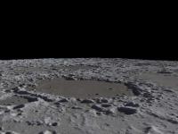
Senior Member Group: Moderator Posts: 3431 Joined: 11-August 04 From: USA Member No.: 98 |
For those of you wondering, as I was, which one is Eddington Crater...
Attached thumbnail(s)
|
|
|
|
|
|
|
Nov 6 2009, 03:29 PM
Post
#52
|
|
|
Founder Group: Chairman Posts: 14433 Joined: 8-February 04 Member No.: 1 |
I had to look it up as well
And S_Walker - the answer is about 2hrs, 40 minutes. The post following yours qualifies I think.Just rendering a near-side 300 frame animation of dawn to dusk with very exaggerated terrain |
|
|
|
|
Nov 6 2009, 05:39 PM
Post
#53
|
|
|
Junior Member Group: Members Posts: 94 Joined: 15-October 09 Member No.: 4979 |
QUOTE (djellison @ Nov 6 2009, 10:29 AM) I had to look it up as well And S_Walker - the answer is about 2hrs, 40 minutes. The post following yours qualifies I think.Thanks. What about those who don't own an iPhone? |
|
|
|
|
Nov 6 2009, 06:07 PM
Post
#54
|
|
|
Founder Group: Chairman Posts: 14433 Joined: 8-February 04 Member No.: 1 |
There's Google Earth/Moon/Mars
|
|
|
|
|
Nov 6 2009, 06:13 PM
Post
#55
|
|
|
Senior Member Group: Moderator Posts: 3431 Joined: 11-August 04 From: USA Member No.: 98 |
QUOTE (djellison @ Nov 6 2009, 11:07 AM) There's Google Earth/Moon/Mars Nah... Google Moon is nice but it doesn't use a topographic map for lighting as far as I remember? And I'm not sure if you can set it to show the view from your backyard. Can Celestia be set to view the Moon from a position on Earth? At least two of us have already produced normal maps; it's a small step from that to the amazing screenshots that volcanopele was posting. I imagine what S_Walker really wants is something that does Bjorn- or Doug- type rendering to show the Moon from a location and time on Earth. Don't know about that. But Celestia or Moon Globe would probably be good enough for a lot of purposes. |
|
|
|
|
Nov 6 2009, 06:33 PM
Post
#56
|
|
|
Junior Member Group: Members Posts: 94 Joined: 15-October 09 Member No.: 4979 |
QUOTE (mhoward @ Nov 6 2009, 01:13 PM) I imagine what S_Walker really wants is something that does Bjorn- or Doug- type rendering to show the Moon from a location and time on Earth. Don't know about that. But Celestia or Moon Globe would probably be good enough for a lot of purposes. Similar; I'd like something like Virtual Moon Atlas or RITI Lunar Map Pro so that I can better plot interesting features to observe under favorable librations each month in Chuck Wood's Explore the Moon column in S&T (I edit it each month). |
|
|
|
|
Nov 6 2009, 06:50 PM
Post
#57
|
|
|
Senior Member Group: Moderator Posts: 3431 Joined: 11-August 04 From: USA Member No.: 98 |
I see. Well as Doug points out, Moon Globe may well be first out the door with those features, for anyone who has an iPhone or iPod Touch. And it's free. I'll be submitting the update using LALT data quite soon. (End promotion.)
I don't own it, but RITI Lunar Map Pro looks like they definitely *should* upgrade to the LALT data for lighting. (Adding: Ironically, the LALT data is actually less sharp than the airbrushed topographic map they seem to be using - I know that because I was using it too. So they may have a problem with that. But even though it's low resolution, the global LALT map we've seen is vastly more accurate.) Virtual Moon Atlas looks like it doesn't do topopgraphic lighting, so that would be more of a reach. |
|
|
|
|
Nov 6 2009, 07:52 PM
Post
#58
|
|
|
Junior Member Group: Members Posts: 35 Joined: 28-September 05 From: Seattle, WA Member No.: 514 |
QUOTE (mhoward @ Nov 6 2009, 10:13 AM) Nah... Google Moon is nice but it doesn't use a topographic map for lighting as far as I remember? And I'm not sure if you can set it to show the view from your backyard. Can Celestia be set to view the Moon from a position on Earth? At least two of us have already produced normal maps; it's a small step from that to the amazing screenshots that volcanopele was posting. Celestia can do this, but the UI for doing so isn't as convenient as one would like. The Celestia UI was designed around moving through space, and features for viewing from the Earth's surface have never gotten the attention that they deserve. But, see question #5 here: http://shatters.net/forum/viewtopic.php?p=118149#p118149 We're in the process of making the Kaguya map the default in Celestia, and a UI overall is coming in the not-too-distant future. --Chris (I've got an iPhone and love the Moon and Mars globe apps, btw. Great work!) |
|
|
|
|
Nov 6 2009, 08:20 PM
Post
#59
|
|
|
Senior Member Group: Moderator Posts: 3431 Joined: 11-August 04 From: USA Member No.: 98 |
Thanks. I'm also a Celestia fan.
|
|
|
|
|
Nov 6 2009, 10:09 PM
Post
#60
|
|
|
Member Group: Members Posts: 890 Joined: 18-November 08 Member No.: 4489 |
mhoward
there will be a hires add on for celestia soon .As soon as i replace my hand made map on the motherload |
|
|
|
|
Nov 6 2009, 11:02 PM
Post
#61
|
|
|
Founder Group: Chairman Posts: 14433 Joined: 8-February 04 Member No.: 1 |
Exagerated rendering : http://www.youtube.com/watch?v=A3MxCvjQDzk and once processed by vimeo http://vimeo.com/7479346
Also uploading to http://www.dougellison.com/dougstuff/kaguy...render_1080.mov - About 10 meg. |
|
|
|
|
Nov 7 2009, 12:22 AM
Post
#62
|
|
|
Senior Member Group: Members Posts: 3648 Joined: 1-October 05 From: Croatia Member No.: 523 |
Oooh, exaggerated is right! Looks great. And kind of creepy, too.
-------------------- |
|
|
|
|
Nov 7 2009, 02:33 AM
Post
#63
|
||
|
Junior Member Group: Members Posts: 23 Joined: 6-November 09 Member No.: 5017 |
My thanks to everyone who made the 16-bit grayscale map possible. I don't have the time right now to play with applying the map to a sphere as I would in Maya or Lightwave, but I have been able to trim out pieces of the map to drop into Terragen, and am very encouraged by the results for use in future artwork. As Bjorn has shown, the data does become somewhat blob-like close up, but Terragen's textures help a bit. This also gets me very excited over the possibilities for using the LOLA data when it becomes available in the coming months.
Rick
|
|
|
|
|
|
|
Nov 7 2009, 04:26 AM
Post
#64
|
|
|
Junior Member Group: Members Posts: 35 Joined: 28-September 05 From: Seattle, WA Member No.: 514 |
Joining in the spinning Moon video party... Here's the Moon rendered with a specular highlight to emphasize topography:
http://www.youtube.com/watch?v=agMcK77p3Hc The overall effect is of looking at a plastic globe. EDIT: Uploaded the wrong video the first time. As pointed out by FordPrefect, there was a 180 degree offset between the normal and albedo maps. --Chris |
|
|
|
|
Nov 7 2009, 05:22 AM
Post
#65
|
|
|
Member Group: Members Posts: 890 Joined: 18-November 08 Member No.: 4489 |
For the past 1 1/2 days i have been trying to get yout???? to except my moon vid ( like the deimos and phobos ) but youtub keeps mangling and f'ing up the ogg file .
http://www.zshare.net/download/68108952dcb3c6a7/ http://www.youtube.com/watch?v=lqxLrig6tQc |
|
|
|
|
Nov 7 2009, 10:36 AM
Post
#66
|
|
|
Junior Member Group: Members Posts: 41 Joined: 12-April 06 Member No.: 738 |
Fantastic Work everyone! I've been hoping for such a DEM since 2003. Spectacular, this global Moon DEM rocks!
QUOTE (claurel @ Nov 7 2009, 05:26 AM) Joining in the spinning Moon video party... Here's the Moon rendered with a specular highlight to emphasize topography: http://www.youtube.com/watch?v=dZCcYIYq5Ok Chris, it seems your DEM map is shifted by 180 degrees in relation to your albedo texture there. |
|
|
|
|
Nov 7 2009, 01:13 PM
Post
#67
|
|
|
Newbie Group: Members Posts: 8 Joined: 20-April 05 Member No.: 276 |
QUOTE (mhoward @ Nov 6 2009, 08:50 PM) Virtual Moon Atlas looks like it doesn't do topopgraphic lighting, so that would be more of a reach. This must change! A new version is in progress and I have added normal map lightning last summer even I was not very happy with the map I can build before this data release. I have downloaded the Kaguya data and I just start to play with them, it look great! This must be released before the end of the year. Patrick |
|
|
|
|
Nov 8 2009, 05:20 PM
Post
#68
|
|||
|
Senior Member Group: Moderator Posts: 3431 Joined: 11-August 04 From: USA Member No.: 98 |
Not just a movie party - a lunar software convention!
Here's a comparison that may be interesting. The first screenshot is Moon Globe with its original, lame pre-Kayuga normal map, and the second is Moon Globe 1.1 with the same view, using my version of the LALT normal map. I've just submitted Moon Globe 1.1 to the App Store, so with any luck it should be showing up in two weeks or so.
Attached thumbnail(s)
|
||
|
|
|
||
|
Nov 8 2009, 08:26 PM
Post
#69
|
|
|
Junior Member Group: Members Posts: 35 Joined: 28-September 05 From: Seattle, WA Member No.: 514 |
Has anyone else noticed a slight misalignment between the Kaguya LALT map and existing albedo maps, specifically those from Clementine?
--Chris |
|
|
|
|
Nov 8 2009, 08:40 PM
Post
#70
|
|
|
Solar System Cartographer Group: Members Posts: 10186 Joined: 5-April 05 From: Canada Member No.: 227 |
Map control from altimeters is much better than the old control - MOLA is the standard for Mars, for instance. In this case the Kaguya control will be far superior to the old Unified Lunar Control Network, which is a mix of control points from Clementine and older missions, basically tens of thousands of points measured on overlapping images. Ultimately we can expect to see older datasets like the Clementine and Lunar Orbiter mosaics, plus the LRO wide angle mosaic, all converted to the altimetry control. LOLA will be the ultimate standard just because of its its high density.
Phil -------------------- ... because the Solar System ain't gonna map itself.
Also to be found posting similar content on https://mastodon.social/@PhilStooke Maps for download (free PD: https://upload.wikimedia.org/wikipedia/comm...Cartography.pdf NOTE: everything created by me which I post on UMSF is considered to be in the public domain (NOT CC, public domain) |
|
|
|
|
Nov 9 2009, 07:16 PM
Post
#71
|
|
|
Junior Member Group: Members Posts: 35 Joined: 28-September 05 From: Seattle, WA Member No.: 514 |
QUOTE (Phil Stooke @ Nov 8 2009, 12:40 PM) Map control from altimeters is much better than the old control... Thanks for your answer, Phil. It sounds like there's nothing to be done about the misalignment for now, but it's good to understand the source of it. --Chris |
|
|
|
|
Nov 9 2009, 07:56 PM
Post
#72
|
|
|
Founder Group: Chairman Posts: 14433 Joined: 8-February 04 Member No.: 1 |
QUOTE (Phil Stooke @ Nov 2 2009, 02:54 PM) So back to the database search. Select LISM datasets, search on Tycho coordinates, then choose TC orthomap, and bingo, lots of datasets. I've had no luck with this yet - how are you using the four coordinates, are you ignoring the time fields, and which instrument sets, specifically are you using. |
|
|
|
|
Nov 9 2009, 08:17 PM
Post
#73
|
|
|
Senior Member Group: Moderator Posts: 3431 Joined: 11-August 04 From: USA Member No.: 98 |
QUOTE (claurel @ Nov 8 2009, 02:26 PM) Has anyone else noticed a slight misalignment between the Kaguya LALT map and existing albedo maps, specifically those from Clementine? I may be mis-remembering here, but if memory serves, there have been two different versions of the Clementine albedo map. I think I'm using the later one - it had some new holes in it that I had to patch up. Whatever I'm using, it seems to me to agree quite well with the LALT data. Again I may be way off here, but the later-model Clementine albedo map might have been re-projected after the Clementine laser altimeter results? |
|
|
|
|
Nov 9 2009, 09:09 PM
Post
#74
|
|
|
Solar System Cartographer Group: Members Posts: 10186 Joined: 5-April 05 From: Canada Member No.: 227 |
Clem laser altimetry was such low resolution that it doesn't help very much here. It's absorbed into the Unified Lunar Control Network. The point really is that, if the Kaguya team did their work properly, which they presumably did, their result will be better than anything older. If there's a mismatch it's more likely to be with the older dataset.
Doug: "I've had no luck with this yet - how are you using the four coordinates, are you ignoring the time fields, and which instrument sets, specifically are you using." First, from the data search page, click product selection - it opens a new window. In it I choose LISM and click 'add all'. The datasets appear in the righthand window. Second, choose (for example) LISM/MAP/TC-Morning-Map, then click 'determination'. Back to the first window - now I select data from that dataset. I ignore time, I use coordinates that bracket an area I'm interested in. For instance, Tycho, lat range -40 to -50, long range 340 to 359. Then click 'search execution'. That takes me to a new page, 'list of search result'. It shows nothing until I again choose the TC morning map line from the product box. But then it lists lots of products, 28 tiles of the big mosaic map. Choose one - click on the file name to see metadata and a thumbnail. Click the order box to order it, and it's put on an FTP server for you. An email tells you how to get it. I have one - it has to be unzipped. I'm still trying to open it, but too busy to do much yet. Phil -------------------- ... because the Solar System ain't gonna map itself.
Also to be found posting similar content on https://mastodon.social/@PhilStooke Maps for download (free PD: https://upload.wikimedia.org/wikipedia/comm...Cartography.pdf NOTE: everything created by me which I post on UMSF is considered to be in the public domain (NOT CC, public domain) |
|
|
|
|
Nov 9 2009, 09:24 PM
Post
#75
|
|
|
Senior Member Group: Moderator Posts: 3431 Joined: 11-August 04 From: USA Member No.: 98 |
QUOTE (Phil Stooke @ Nov 9 2009, 03:09 PM) Clem laser altimetry was such low resolution that it doesn't help very much here. It's absorbed into the Unified Lunar Control Network. The point really is that, if the Kaguya team did their work properly, which they presumably did, their result will be better than anything older. If there's a mismatch it's more likely to be with the older dataset. Thanks for the correction. Still, I believe there was a version 1 of the Clementine albedo map that was pre-Lunar Control Network, even. If you happen to be using that, I imagine it doesn't match up with the LALT data very well at all. |
|
|
|
|
Nov 10 2009, 12:50 AM
Post
#76
|
||
|
Newbie Group: Members Posts: 14 Joined: 9-November 09 Member No.: 5032 |
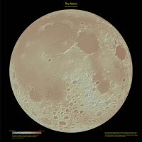
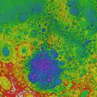
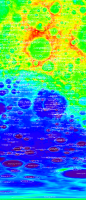
I downloaded the Kaguya LALT_GGT_NUM data set from JAXA and built a digital terrain model with ArcGIS software. I then applied some hypsometric rendering techniques and made these maps. Here's the first map, a global view of the moon built from the surface model and no albedo data.
Attached thumbnail(s)
|
|
|
|
|
|
|
Nov 10 2009, 12:51 AM
Post
#77
|
||
|
Newbie Group: Members Posts: 14 Joined: 9-November 09 Member No.: 5032 |
Another lunar hypsometric map, the near side of the moon
Attached thumbnail(s)
|
|
|
|
|
|
|
Nov 10 2009, 12:52 AM
Post
#78
|
||
|
Newbie Group: Members Posts: 14 Joined: 9-November 09 Member No.: 5032 |
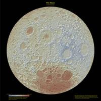
The far side of the moon.
Attached thumbnail(s)
|
|
|
|
|
|
|
Nov 10 2009, 12:56 AM
Post
#79
|
||
|
Newbie Group: Members Posts: 14 Joined: 9-November 09 Member No.: 5032 |
Here's the north pole perspective
Attached thumbnail(s)
|
|
|
|
|
|
|
Nov 10 2009, 01:01 AM
Post
#80
|
||
|
Newbie Group: Members Posts: 14 Joined: 9-November 09 Member No.: 5032 |
And the perspective above the south pole of the moon.
If you are curious about my mapping method, I applied the cartographic tools described at http://blogs.esri.com/Support/blogs/mappin...de-toolbox.aspx This is a modern implementation of the cartographic relief methods developed by the Swiss cartographer Eduard Imhof in the 1930's. Originally designed for maps of the Alps, this mapping method shows a new "perspective" of the moon. It's a bit weird looking at the "naked" moon without it's ray systems and albedo differences between the mare and highlands, but it's still pretty recognizable. In term of hypsometric relief, the far side is much more interesting then the near side. regards, Michael Zeiler, ESRI
Attached thumbnail(s)
|
|
|
|
|
|
|
Nov 10 2009, 02:40 AM
Post
#81
|
|
|
Junior Member Group: Members Posts: 35 Joined: 28-September 05 From: Seattle, WA Member No.: 514 |
QUOTE (mhoward @ Nov 9 2009, 01:24 PM) Thanks for the correction. Still, I believe there was a version 1 of the Clementine albedo map that was pre-Lunar Control Network, even. If you happen to be using that, I imagine it doesn't match up with the LALT data very well at all. I can confirm that newer (or perhaps just 'other') versions of the Clementine albedo map do match up better with the LALT data. Unfortunately, the Clementine map that does align well also suffers from the gaps that you mentioned. --Chris |
|
|
|
|
Nov 10 2009, 09:35 AM
Post
#82
|
|
|
Member Group: Members Posts: 890 Joined: 18-November 08 Member No.: 4489 |
i used the "Clem_NIR_V0.1 " 5 band pds data for my map and there is a misalignment
ftp://pdsimage2.wr.usgs.gov/cdroms/clementine/Clem_NIR_V0.1/ texture with the normal [attachment=19612:moon1.jpg] without the normal [attachment=19613:moon2.jpg] some of this might be from the new topo has 0.0 long in the middle on the pixel and the texture is at the left edge of the pixel the normal was bumped up to 8192x4096 image from the LALT_GGT_MAP.IMG header " and from +0.03125 to +359.96875 degrees in longitude." |
|
|
|
|
Nov 12 2009, 09:47 AM
Post
#83
|
|
|
IMG to PNG GOD Group: Moderator Posts: 2251 Joined: 19-February 04 From: Near fire and ice Member No.: 38 |
A decided to do a rotation movie. The "subspacecraft" latitude is 10°S, the phase angle ~70°, the field of view 25° and the distance from the Moon's center 12000 km. In a way this feels like looking at a new planet/satellite. I have not been interested in doing Moon renders until now because no DEM that I considered good enough was available.
 lunar_rotation_movie.avi ( 6.29MB )
Number of downloads: 3595
lunar_rotation_movie.avi ( 6.29MB )
Number of downloads: 3595 |
|
|
|
|
Nov 14 2009, 11:25 PM
Post
#84
|
||
|
Founder Group: Chairman Posts: 14433 Joined: 8-February 04 Member No.: 1 |
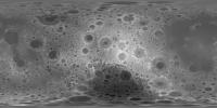
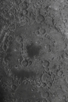
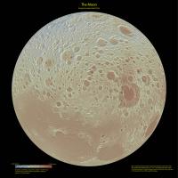
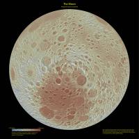
Bit of fun turning the elevation map into a coloured gradient, followed by a lighting effect (using the elevation map) - and then polar projecting the whole thing around the south pole. the result is fairly profound!
Attached thumbnail(s)
|
|
|
|
|
|
| Guest_mcgyver_* |
Nov 15 2009, 01:23 PM
Post
#85
|
|
Guests |
An italian guy here is looking for somebody able to make a 3d animation of the apollo landing sites:
http://moonscape-project.blogspot.com/2009...-moonscape.html Is anyone of you able? --------- I would like to see Kahuya data in WorldWind, but it does not run as a webstart application on my internet-connected PC, so I'd like to download it and install it on another PC: any tips about where to download an offline version? |
|
|
|
|
Nov 15 2009, 05:48 PM
Post
#86
|
|
|
Senior Member Group: Members Posts: 1585 Joined: 14-October 05 From: Vermont Member No.: 530 |
QUOTE (djellison @ Nov 14 2009, 06:25 PM) Bit of fun turning the elevation map into a coloured gradient, followed by a lighting effect (using the elevation map) - and then polar projecting the whole thing around the south pole. the result is fairly profound! Beautiful image! |
|
|
|
|
Nov 15 2009, 06:09 PM
Post
#87
|
|
|
Newbie Group: Members Posts: 2 Joined: 14-November 09 Member No.: 5043 |
QUOTE (elakdawalla @ Nov 2 2009, 12:07 AM) I just received the following from Shin-ichi Sobue at JAXA:I wish I could post some images but I'm having a bit of trouble with the Data Archive website -- got registered OK, but my searches seem to return database errors. And I couldn't seem to find my way to Terrain Camera data. Perhaps it's because my brain is somewhat mushy from a day of football and beer But I give up for the night and give you guys the link in the hopes you can figure out how to get pretty pictures out of this website!I've attached the whole doc that Shin-ichi sent me, which contains a little more info about the data sets in the release. --Emily I've downloaded some data from the SELENE website for the MI instrument, I'm trying to open the IMG file but not having much luck. I've tried importing it with ERDAS, opening it with multispec, and also ImageJ. Can anyone give some pointers on getting the PDS3 IMG files to open in some software? I'm still abit new to the non earth data thing. Thanks. |
|
|
|
|
Nov 15 2009, 06:42 PM
Post
#88
|
|
|
Founder Group: Chairman Posts: 14433 Joined: 8-February 04 Member No.: 1 |
Things I try (usually in this order)
NASAView ImageJ with PDS Plugin img2png a very very large drink followed by ISIS3 |
|
|
|
|
Nov 16 2009, 07:42 AM
Post
#89
|
|
|
Member Group: Members Posts: 890 Joined: 18-November 08 Member No.: 4489 |
QUOTE I've downloaded some data from the SELENE website i was able to open them using isis3 and the " raw2isis" once i opened then in ghex to find out how big the header was pds2isis and vicar2isis failed QUOTE a very very large drink followed by ISIS3 funny , ha ha |
|
|
|
|
Nov 17 2009, 05:35 PM
Post
#90
|
|
|
Senior Member Group: Moderator Posts: 3431 Joined: 11-August 04 From: USA Member No.: 98 |
Just to join the rotation movie party: Moon Globe rotation movie on YouTube.
|
|
|
|
|
Nov 18 2009, 12:41 AM
Post
#91
|
|
|
Newbie Group: Members Posts: 2 Joined: 14-November 09 Member No.: 5043 |
I finally got my copy of ENVI running. Opening the MI data was easiest with ENVI. Thanks for the tips tho!
|
|
|
|
|
Nov 18 2009, 08:09 PM
Post
#92
|
||
|
Junior Member Group: Members Posts: 89 Joined: 27-August 05 From: Eccentric Mars orbit Member No.: 477 |
I don't know if this is well known or not, but I am a bit surprised to not see this discussed here. The highest point on the Kaguya data, and therefore their idea of "Mt Everest" is on the wall of a crater, which itself is on the wall of a 500km unnamed crater just north of crater Korolev on the far side
alt: 10715 image x,y: 342 1526 (from bottom right of image) lon,lat: 158.625W 5.375N The lowest point ("Challenger Deep") is on the floor of 140km diameter Antoniadi crater, also on the far side in the South Polar basin. alt: -9138 image x,y: 120 314 lon,lat: 172.5W 70.375S Both of these points are unique, in that there are no other points with the same elevation in the data.
This map has all the craters I could find a list for, the highest point marked in black in the red area near the top, and the lowest point is marked in red in the deep purple area near the bottom. If the crater has a name, it's not in my list and I would love to know it. Edit: Emily already mentioned this in the middle of her blog entry, so no discoveries here. I didn't find any of this until I looked up "Antoniadi" on Google. That "unnamed" crater apparently is provisionally named Dirichlet-Jackson. |
|
|
|
|
|
|
Nov 19 2009, 01:25 AM
Post
#93
|
|
|
Senior Member Group: Moderator Posts: 3431 Joined: 11-August 04 From: USA Member No.: 98 |
Here's a better Moon Globe rotation movie at an oblique angle.
|
|
|
|
|
Nov 19 2009, 07:23 AM
Post
#94
|
|
|
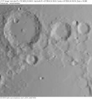
Member Group: Members Posts: 890 Joined: 18-November 08 Member No.: 4489 |
as to the high and low points i have been finding "noise" in the 5760x2880.img
the low point looks like a single pix ( 16bit unsigned "0" in a crater that avg about 300 to 500 ) .I would need to find it again to double check . i just checked and there is noise but not these two points nip2 tells me the min is at ( 120x2565 ) max is at ( 342x1353) min [attachment=19712:Screenshot_min.png] max [attachment=19713:Screenshot_max.png] |
|
|
|
|
Nov 20 2009, 09:03 PM
Post
#95
|
|
|
Newbie Group: Members Posts: 8 Joined: 19-November 09 Member No.: 5052 |
QUOTE (kwan3217 @ Nov 18 2009, 09:09 PM) This map has all the craters I could find a list for, the highest point marked in black in the red area near the top, and the lowest point is marked in red in the deep purple area near the bottom. If the crater has a name, it's not in my list and I would love to know it. Kwan, The definitive source of lunar names is the IAU Planetary Gazetteer, the most useful version of which, for the present purpose, is Jennifer Blue's Digital Nomenclature Atlas. The high point you located is on the rim of a 43-km diameter crater called Engel'gardt in LAC 69 -- actually on the shared rim of Engel'gardt and the larger ("136 km") Engel'gardt B. You can see a grayscale version of the Kaguya global DEM for this area, with all the current IAU names superimposed using a software called LTVT, here. The misregistration of some of the features relative to where they appear in the Kaguya data is due to inaccuracies in the IAU data, which were originally intended only to be accurate enough to unambiguously identify what feature was meant by each name. I understand the IAU coordinates and diameters may be redone next year using newer and better controlled images. -- Jim |
|
|
|
|
Nov 21 2009, 06:29 PM
Post
#96
|
|
|
Newbie Group: Members Posts: 1 Joined: 20-November 09 Member No.: 5053 |
QUOTE (Michael Zeiler @ Nov 10 2009, 01:50 AM) I downloaded the Kaguya LALT_GGT_NUM data set from JAXA and built a digital terrain model with ArcGIS software. Really nice work Michael. Could you give a short tutorial on how to import the data and convert it into a DEM? What projections are to be used? |
|
|
|
|
Nov 21 2009, 08:43 PM
Post
#97
|
|
|
Newbie Group: Members Posts: 8 Joined: 19-November 09 Member No.: 5052 |
QUOTE (S_Walker @ Nov 6 2009, 01:41 PM) I wonder when we'll see the first program that accurately renders this topographical data so we can really plan our lunar observations... Sean, You may wish to check today's LPOD. -- Jim |
|
|
|
|
Nov 22 2009, 04:43 AM
Post
#98
|
|
|
Newbie Group: Members Posts: 14 Joined: 9-November 09 Member No.: 5032 |
QUOTE (Carsten @ Nov 21 2009, 11:29 AM) Really nice work Michael. Could you give a short tutorial on how to import the data and convert it into a DEM? What projections are to be used? Carsten, I'm glad you like the maps. My method applies the following steps with ArcGIS software (www.esri.com): After downloading the large LALT_GGT_NUM dataset from the JAXA, I used an ArcGIS tool called "ASCII 3D to Feature Class". This tool is designed to import an ASCII file with x,y,z values to create a multipoint feature class, a point data structure designed to scale up to billions of elevation points, such as you encounter with lidar data. From the multipoint feature class, I created a terrain dataset. A terrain dataset is a generic GIS data structure which is essentially a multi-resolution triangulated irregular network. See http://webhelp.esri.com/arcgisdesktop/9.3/...ataset_concepts From the terrain dataset, I exported a raster dataset. From the raster dataset, I applied a geoprocessing model that applies two cartographic effects: hillshaded-relief plus hypsometric tints using a color ramp. This model is described at http://blogs.esri.com/Support/blogs/mappin...de-toolbox.aspx This technique is a modern implementation of shaded relief pioneered by the Swiss cartographer, Eduard Imhof, in his classic book, Cartographic Relief Presentation, first published in 1965. In those maps, I use two map projections, Mollweide for the full global view of the Moon, and Orthographic for the four hemispheric views. Through my work, I have access to the ArcGIS software suite. This is professional grade GIS software that most space enthusiasts could not casually purchase, so I know that my method is not easily adapted by most on this forum. But this was a quick and fun project for me because I am presently writing a textbook on geographic data modeling and this was a good application of terrain visualization methods. Also, when I examined the DEM built from the LALT_GGT_NUM dataset, I found a large fictitious lunar mountain at selenographic coordinates 16d 11m N, 87d 33m E I made a slope map from the Kaguya DEM and categorized the peaks with the greatest slopes on the Moon. Some suspicious lunar peaks are at 48 19 S, 141 22 E, 63 degree slope 16 11 N, 87 33 E, 60 degree slope 20 56 N, 60 32 E, 58 degree slope 48 11 S, 8 48 W, 56 degree slope 32 26 S, 58 57 E, 55 degree slope 22 15 N, 81 53 E, 52 degree slope 59 11 S, 46 16 E, 50 degree slope 61 38 N, 8 16 W, 47 degree slope 66 29 N, 70 10 W, 46 degree slope I don't necessarily assert each one of the peaks are false, but they are suspicious because of their high slope values. regards, Michael Zeiler ESRI |
|
|
|
|
Nov 22 2009, 01:27 PM
Post
#99
|
|
|
Solar System Cartographer Group: Members Posts: 10186 Joined: 5-April 05 From: Canada Member No.: 227 |
Your maps are very nice indeed, Michael.
Apparent peaks caused by bad pixels in the original data are found in many raw DEMs and can be edited out if necessary. A good example can be seen in Google Earth's Moon map at 10.8114 N, 54.3234 E on the southern edge of Mare Crisium - pointed out by Joel Raupe. This is in the high resolution DEM on the Apollo 15 Metric camera strip in that map. Phil -------------------- ... because the Solar System ain't gonna map itself.
Also to be found posting similar content on https://mastodon.social/@PhilStooke Maps for download (free PD: https://upload.wikimedia.org/wikipedia/comm...Cartography.pdf NOTE: everything created by me which I post on UMSF is considered to be in the public domain (NOT CC, public domain) |
|
|
|
|
Nov 23 2009, 04:28 AM
Post
#100
|
|||
|
Newbie Group: Members Posts: 8 Joined: 19-November 09 Member No.: 5052 |
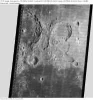
QUOTE (Michael Zeiler @ Nov 22 2009, 05:43 AM) Carsten, Also, when I examined the DEM built from the LALT_GGT_NUM dataset, I found a large fictitious lunar mountain at selenographic coordinates 16d 11m N, 87d 33m E ... Michael, Your 3D renderings (as featured on today's LPOD) are indeed very lovely, but are you sure your coordinate readouts are correct? The Kaguya DEM definitely has some small-scale glitches -- including bad cells, completely missing some craters of ~10 km diameter and representing others as hills -- but I can find nothing particularly strange at the locations you mention. For example, if I am not mistaken, 16d 11m N, 87d 33m E should be sample 1401 in line 1342 of the global DEM. The elevation listed there (at least in the machine-readable, floating point LALT_GGT_MAP.IMG) is -1.490 km (relative to the 1737.4 km reference). None of the 8 nearest neighbor cells differ by more than 100 m (most by much less), which over 1/16th degree (~1.9 km) gives slopes of 3 deg or less. The "large fictitious lunar mountain" you report should be at the exact center of the two attachments (produced with LTVT), which compare the area (with Neper in the upper left) as viewed by Lunar Orbiter IV (1967 May 11 17:30:07 UT) and as predicted for the same circumstances using the Kaguya DEM. I am unable to see anything particularly anomalous at that the center of these images. -- Jim
Attached thumbnail(s)
|
||
|
|
|
||
|

|
Lo-Fi Version | Time is now: 6th June 2024 - 04:47 AM |
|
RULES AND GUIDELINES Please read the Forum Rules and Guidelines before posting. IMAGE COPYRIGHT |
OPINIONS AND MODERATION Opinions expressed on UnmannedSpaceflight.com are those of the individual posters and do not necessarily reflect the opinions of UnmannedSpaceflight.com or The Planetary Society. The all-volunteer UnmannedSpaceflight.com moderation team is wholly independent of The Planetary Society. The Planetary Society has no influence over decisions made by the UnmannedSpaceflight.com moderators. |
SUPPORT THE FORUM Unmannedspaceflight.com is funded by the Planetary Society. Please consider supporting our work and many other projects by donating to the Society or becoming a member. |
|