The Top of Vera Rubin Ridge Part 1, Site 66-67, sol 1812-1943, 11 Sep 2017-23 Jan 2018 |

  |
The Top of Vera Rubin Ridge Part 1, Site 66-67, sol 1812-1943, 11 Sep 2017-23 Jan 2018 |
 Sep 11 2017, 09:50 AM Sep 11 2017, 09:50 AM
Post
#1
|
||
 Senior Member  Group: Members Posts: 2429 Joined: 30-January 13 From: Penang, Malaysia. Member No.: 6853 |
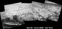
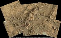
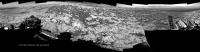
Welcome to Route 66... Er, make that Site 66
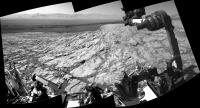
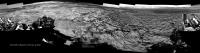
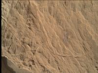
 Drive 0000 on Sol 1812. Roughly stitched L-NavCam using MS ICE Midnight Planets reporting it as ~5.6m ESE (115º) link
|
|
 |
 
|
|
|
Sep 11 2017, 08:19 PM
Post
#2
|
|
 Administrator Group: Admin Posts: 5172 Joined: 4-August 05 From: Pasadena, CA, USA, Earth Member No.: 454 |
A new site seems like a good spot to make the split to a new thread.
-------------------- My website - My Patreon - @elakdawalla on Twitter - Please support unmannedspaceflight.com by donating here.
|
|
|
|
|
Sep 13 2017, 05:15 AM
Post
#3
|
||
|
Senior Member Group: Members Posts: 2429 Joined: 30-January 13 From: Penang, Malaysia. Member No.: 6853 |
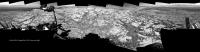
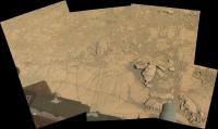
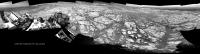
After the short drive on sol 1814 here's a quick-n-dirty NLB 360 pan, Please delete when the complete version is posted, this may help fix the location.
|
|
|
|
|
|
|
Sep 13 2017, 09:28 AM
Post
#4
|
||
|
Senior Member Group: Members Posts: 2833 Joined: 22-April 05 From: Ridderkerk, Netherlands Member No.: 353 |
The Navcam L view on Sol 1814.
Jan van Driel
|
|
|
|
|
|
|
Sep 13 2017, 09:49 AM
Post
#5
|
||
|
Senior Member Group: Members Posts: 2833 Joined: 22-April 05 From: Ridderkerk, Netherlands Member No.: 353 |
and the view looking back ( North ) on Sol 1814.
Jan van Driel
|
|
|
|
|
|
|
Sep 13 2017, 11:01 PM
Post
#6
|
||
|
Senior Member Group: Members Posts: 1044 Joined: 17-February 09 Member No.: 4605 |
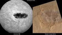
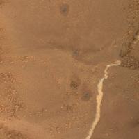
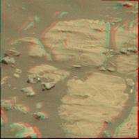
The really fine laminations indicate suspension fallout in reasonably deep still water, so the crater was experiencing a wet environment when this level was laid down. Given the original permeability of the deposits my horribly unreliable intuition suspects that the hematite developed during a dry cycle via a mixing interface between groundwater and water infiltrating from a disconnected stream, fed by acidic meltwater at the beginning of the volcanic period that gave rise to the sulphate formation. Development in an open rather than closed environment.
Attached thumbnail(s)
|
|
|
|
|
|
|
Sep 14 2017, 06:24 AM
Post
#7
|
||
|
Solar System Cartographer Group: Members Posts: 10166 Joined: 5-April 05 From: Canada Member No.: 227 |
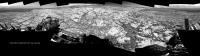
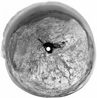
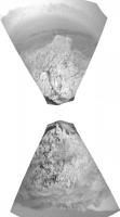
One of Jan's panoramas in circular form.
Phil
-------------------- ... because the Solar System ain't gonna map itself.
Also to be found posting similar content on https://mastodon.social/@PhilStooke Maps for download (free PD: https://upload.wikimedia.org/wikipedia/comm...Cartography.pdf NOTE: everything created by me which I post on UMSF is considered to be in the public domain (NOT CC, public domain) |
|
|
|
|
|
|
Sep 14 2017, 08:03 AM
Post
#8
|
||
|
Senior Member Group: Members Posts: 2429 Joined: 30-January 13 From: Penang, Malaysia. Member No.: 6853 |
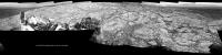
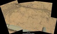
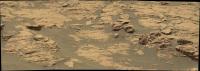
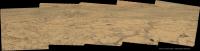
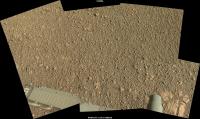
Sol 1814 post drive workspace, assembled in MS ICE, raw colour, no additional processing.
|
|
|
|
|
|
|
Sep 14 2017, 11:39 AM
Post
#9
|
|
|
Member Group: Members Posts: 910 Joined: 4-September 06 From: Boston Member No.: 1102 |
QUOTE (serpens @ Sep 13 2017, 07:01 PM)  The really fine laminations indicate suspension fallout in reasonably deep still water, so the crater was experiencing a wet environment when this level was laid down. Given the original permeability of the deposits my horribly unreliable intuition suspects that the hematite developed during a dry cycle via a mixing interface between groundwater and water infiltrating from a disconnected stream, fed by acidic meltwater at the beginning of the volcanic period that gave rise to the sulphate formation. Development in an open rather than closed environment. I assume the spot was cleared of dust by laser blasts, not by brushing? If so I don't think I have ever seen this type of cleaning. Might the shiny surface be hematite? Not berries, but sheets??? -------------------- |
|
|
|
|
Sep 14 2017, 09:30 PM
Post
#10
|
||
|
Senior Member Group: Members Posts: 2429 Joined: 30-January 13 From: Penang, Malaysia. Member No.: 6853 |
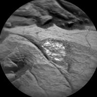
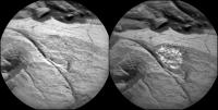
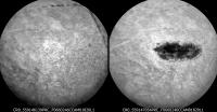
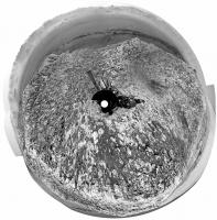
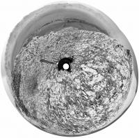
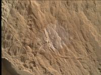
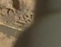
QUOTE (Floyd @ Sep 14 2017, 07:39 PM) I assume the spot was cleared of dust by laser blasts, not by brushing? If so I don't think I have ever seen this type of cleaning. Might the shiny surface be hematite? Not berries, but sheets??? It appears to be LIBS of an AEGIS target. Here is the before and after LIBS. The eroded surface seems to have small 'facets' for want of a better description. Certainly an interesting site...
|
|
|
|
|
|
|
Sep 16 2017, 01:18 AM
Post
#11
|
|
|
Senior Member Group: Members Posts: 1044 Joined: 17-February 09 Member No.: 4605 |
Specular reflections which is a pointer to crystalline minerals. Given that this is the hematite cemented ridge we could punt for hematite / goethite.
|
|
|
|
|
Sep 16 2017, 08:31 AM
Post
#12
|
|||
|
Senior Member Group: Members Posts: 2429 Joined: 30-January 13 From: Penang, Malaysia. Member No.: 6853 |
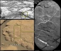
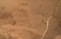
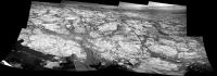
2 MAHLI's from Sol 1816 of the fractured sedimentary bedrock in front of the rover. The first is a context frame, the second is a focus merged product of the center of the context frame. The surface dust is more abundant on certain areas, probably just on the 'flatter sections' but at first glance I thought is was concentrated at specific laminations
Links ONE and TWO |
||
|
|
|
||
|
Sep 16 2017, 11:48 AM
Post
#13
|
||
|
Senior Member Group: Members Posts: 2429 Joined: 30-January 13 From: Penang, Malaysia. Member No.: 6853 |
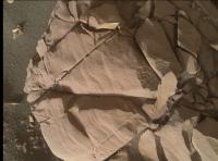
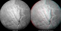
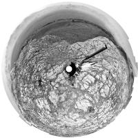
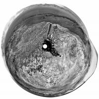
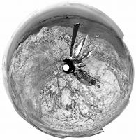
ChemCam RMI Z-stack & red/cyan anaglyph of fine laminations in the target "Phoney Island".
Assembled using the 7 'ENHANCED Data Products' posted by JPL of the 9 RMI frames acquired, it may be possible to pull some more detail from all 9 if the missing 2 turn up as enhanced files. I used PICOLAY to assembled the Z-Stack and the anaglyph shown here. I'm sure JPL's 3D model will be much better than this basic version, but it was fun making it
|
|
|
|
|
|
|
Sep 16 2017, 12:38 PM
Post
#14
|
|||
 Member Group: Members Posts: 684 Joined: 24-July 15 Member No.: 7619 |
QUOTE (PaulH51 @ Sep 16 2017, 08:31 AM) 2 MAHLI's from Sol 1816 of the fractured sedimentary bedrock in front of the rover.
Curious, raindrop mark?
Attached thumbnail(s)
|
||
|
|
|
||
|
Sep 17 2017, 11:48 PM
Post
#15
|
||
|
Senior Member Group: Members Posts: 1044 Joined: 17-February 09 Member No.: 4605 |
After all those fine laminations, now for somethiing a little different.
Attached thumbnail(s)
|
|
|
|
|
|
|
Sep 18 2017, 05:23 AM
Post
#16
|
|||
|
Senior Member Group: Members Posts: 2429 Joined: 30-January 13 From: Penang, Malaysia. Member No.: 6853 |
QUOTE (serpens @ Sep 18 2017, 07:48 AM) After all those fine laminations, now for somethiing a little different. Hmmmmm definitely different Looks rather complex, so better get back to the fine laminations
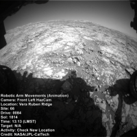
A simple 12 frame HazCam animation of some of the arm work at the current location, hopefully I interpreted the target names correctly from the Mission Update
Link in case animation wont play LINK |
||
|
|
|
||
|
Sep 18 2017, 07:09 PM
Post
#17
|
||
|
Senior Member Group: Members Posts: 2833 Joined: 22-April 05 From: Ridderkerk, Netherlands Member No.: 353 |
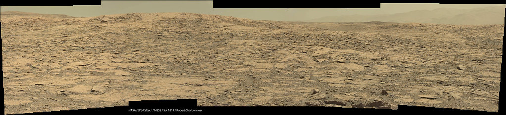
The Navcam L view on Sol 1819.
Jan van Driel
|
|
|
|
|
|
|
Sep 19 2017, 05:27 PM
Post
#18
|
|
|
Senior Member Group: Members Posts: 1074 Joined: 21-September 07 From: Québec, Canada Member No.: 3908 |
The Lmastcam view on sol 1819:
|
|
|
|
|
Sep 20 2017, 06:54 AM
Post
#19
|
||
|
Senior Member Group: Members Posts: 2429 Joined: 30-January 13 From: Penang, Malaysia. Member No.: 6853 |
Sol 1819 Workspace from the left MastCam (Raw in MS ICE)
Note some lovely colour variations when you stretch the colours, and is that another little iron meteorite in the upper left? Or is that just my wishful thinking
|
|
|
|
|
|
|
Sep 20 2017, 07:30 AM
Post
#20
|
||
|
Senior Member Group: Members Posts: 2429 Joined: 30-January 13 From: Penang, Malaysia. Member No.: 6853 |
Well I can't claim to have seen a reaction like that to a ChemCam LIBS session
 ) )The plan for Sol 1821 has several ChemCam targets, but this is a first to come down, maybe they turned up the power to celebrate the 500k shot of the laser
|
|
|
|
|
|
|
Sep 20 2017, 11:18 AM
Post
#21
|
||
|
Solar System Cartographer Group: Members Posts: 10166 Joined: 5-April 05 From: Canada Member No.: 227 |
Yes, that does look interesting.
This is Jan's panorama for sol 1819 in circular form. The rocky pavement is a big change from so many sols among broken rocks. Phil PS - I'm in Salisbury, UK for the next few weeks. If any UMSF fans want to meet up send me a message.
-------------------- ... because the Solar System ain't gonna map itself.
Also to be found posting similar content on https://mastodon.social/@PhilStooke Maps for download (free PD: https://upload.wikimedia.org/wikipedia/comm...Cartography.pdf NOTE: everything created by me which I post on UMSF is considered to be in the public domain (NOT CC, public domain) |
|
|
|
|
|
|
Sep 20 2017, 07:59 PM
Post
#22
|
|
 Member Group: Members Posts: 655 Joined: 22-January 06 Member No.: 655 |
QUOTE (Phil Stooke @ Sep 20 2017, 12:18 PM) PS - I'm in Salisbury, UK for the next few weeks. If any UMSF fans want to meet up send me a message Phil, it would be great to meet up for a natter re all things umsf and (horrors!) msf..... I live less than 30 miles from Salisbury, and Ian Regan is Plymouth-based, perhaps we could have a mini-summit. Any other umsf'ers that could make it while Phil's in the UK? |
|
|
|
|
Sep 21 2017, 03:17 AM
Post
#23
|
||
|
Senior Member Group: Members Posts: 2429 Joined: 30-January 13 From: Penang, Malaysia. Member No.: 6853 |
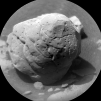
Looks like we can add another small iron meteorite to the list
Sol 1821, not got the R-MastCam context frame yet. |
|
|
|
|
|
|
Sep 21 2017, 09:36 AM
Post
#24
|
|
|
Solar System Cartographer Group: Members Posts: 10166 Joined: 5-April 05 From: Canada Member No.: 227 |
That really does look like a meteorite! From the update, it is called Mustards Island.
Phil (PS - I am replying to jasedm privately but if anyone else is nearby, send a message) -------------------- ... because the Solar System ain't gonna map itself.
Also to be found posting similar content on https://mastodon.social/@PhilStooke Maps for download (free PD: https://upload.wikimedia.org/wikipedia/comm...Cartography.pdf NOTE: everything created by me which I post on UMSF is considered to be in the public domain (NOT CC, public domain) |
|
|
|
|
Sep 21 2017, 03:34 PM
Post
#25
|
|
|
Senior Member Group: Members Posts: 2429 Joined: 30-January 13 From: Penang, Malaysia. Member No.: 6853 |
QUOTE (Phil Stooke @ Sep 21 2017, 05:36 PM) That really does look like a meteorite! From the update, it is called Mustards Island. Only one ChemCam-RMI image of Mustard Island came down (so far), so looks like it was not zapped, even though it was inside the range of the laser, so I guess we'll never know for sure, but I'm still calling it a meteorite EDIT: strike that comment, they did zap it LINK and that zap took the laser hits above 500k
|
|
|
|
|
Sep 22 2017, 02:25 AM
Post
#26
|
||
|
Senior Member Group: Members Posts: 2429 Joined: 30-January 13 From: Penang, Malaysia. Member No.: 6853 |
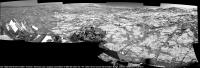
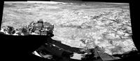
Quick and dirty partial pan of the L-NavCams after the nice drive on sol 1822. Mods can delete after the full version is posted. Some long awaited views of the distant target destinations gradually coming into view
|
|
|
|
|
|
|
Sep 22 2017, 02:18 PM
Post
#27
|
||
|
Senior Member Group: Members Posts: 2833 Joined: 22-April 05 From: Ridderkerk, Netherlands Member No.: 353 |
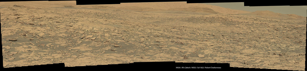
The Navcam L view on Sol 1822.
Jan van Driel
|
|
|
|
|
|
|
Sep 22 2017, 02:54 PM
Post
#28
|
||
|
Solar System Cartographer Group: Members Posts: 10166 Joined: 5-April 05 From: Canada Member No.: 227 |
Thanks, Jan. Here it is in circular format.
Phil
-------------------- ... because the Solar System ain't gonna map itself.
Also to be found posting similar content on https://mastodon.social/@PhilStooke Maps for download (free PD: https://upload.wikimedia.org/wikipedia/comm...Cartography.pdf NOTE: everything created by me which I post on UMSF is considered to be in the public domain (NOT CC, public domain) |
|
|
|
|
|
|
Sep 22 2017, 07:08 PM
Post
#29
|
|
|
Senior Member Group: Members Posts: 1074 Joined: 21-September 07 From: Québec, Canada Member No.: 3908 |
The sol 1822 Lmastcam view:
|
|
|
|
|
Sep 22 2017, 10:17 PM
Post
#30
|
||
|
Senior Member Group: Members Posts: 2429 Joined: 30-January 13 From: Penang, Malaysia. Member No.: 6853 |
Latest L-MastCam workspace assembled in MS ICE (Sol 1822)
|
|
|
|
|
|
|
Sep 23 2017, 12:48 PM
Post
#31
|
|
|
Solar System Cartographer Group: Members Posts: 10166 Joined: 5-April 05 From: Canada Member No.: 227 |
Apparently we are now in a new quadrangle. Names from the latest status report include Sherwood Forest and Troll Valley, taken from the 1883 novel The Merry Adventures of Robin Hood by Howard Pyle. Previous quads took names from geological features of the areas which gave the quads their names. I don't know what this quad will be named. If anyone can fill us in, I would be grateful.
Phil -------------------- ... because the Solar System ain't gonna map itself.
Also to be found posting similar content on https://mastodon.social/@PhilStooke Maps for download (free PD: https://upload.wikimedia.org/wikipedia/comm...Cartography.pdf NOTE: everything created by me which I post on UMSF is considered to be in the public domain (NOT CC, public domain) |
|
|
|
|
Sep 24 2017, 06:25 AM
Post
#32
|
||
|
Senior Member Group: Members Posts: 2429 Joined: 30-January 13 From: Penang, Malaysia. Member No.: 6853 |
QUOTE (PaulH51 @ Sep 20 2017, 03:30 PM) Well I can't claim to have seen a reaction like that to a ChemCam LIBS session )I believe this may be one of the MAHLI's of the sol 1821 odd looking ChemCam target I posted a few days back. Rotated & cropped, in raw colour and presented side-by-side with the RMI. Looks like the liberal coating of dust and the darker bedrock gave us the interesting B&W image
|
|
|
|
|
|
|
Sep 24 2017, 07:04 AM
Post
#33
|
|
|
Senior Member Group: Members Posts: 1044 Joined: 17-February 09 Member No.: 4605 |
That does seem to be the target, good eyes there Paul. The RMI operating range is 400 nm to 840 nm so there was possibly a big spike in one section of the reflectance spectra.
|
|
|
|
|
Sep 25 2017, 03:34 AM
Post
#34
|
|
|
Senior Member Group: Members Posts: 2429 Joined: 30-January 13 From: Penang, Malaysia. Member No.: 6853 |
QUOTE (serpens @ Sep 24 2017, 03:04 PM) ...The RMI operating range is 400 nm to 840 nm so there was possibly a big spike in one section of the reflectance spectra. Thanks for the tip on the camera's optical range and the possible spike
|
|
|
|
|
Sep 25 2017, 10:51 AM
Post
#35
|
||
|
Senior Member Group: Members Posts: 2429 Joined: 30-January 13 From: Penang, Malaysia. Member No.: 6853 |
I think this sol 1822 ChemCam target is Hypocrites Ledge, I added the R-MastCam context image as well as a small mosaic of R-NavCam images to the 4 frame RMI mosaic. AlgorimancerPG was used to create the scale bar.
|
|
|
|
|
|
|
Sep 27 2017, 04:47 AM
Post
#36
|
||
|
Senior Member Group: Members Posts: 2429 Joined: 30-January 13 From: Penang, Malaysia. Member No.: 6853 |
Quick and Dirty R-NavCam after the short drive on 1827.
Page mods can delete when the good version is posted
|
|
|
|
|
|
|
Sep 27 2017, 05:09 AM
Post
#37
|
|
|
Senior Member Group: Members Posts: 1044 Joined: 17-February 09 Member No.: 4605 |
Well the depositional environment is certainly changing as we get closer to the top of the ridge.
|
|
|
|
|
Sep 27 2017, 06:32 AM
Post
#38
|
|
|
Member Group: Members Posts: 184 Joined: 2-March 06 Member No.: 692 |
Almost looks like tree rings. Very uniform in thickness I think. Seasonal?
|
|
|
|
|
Sep 27 2017, 09:50 AM
Post
#39
|
||
|
Senior Member Group: Members Posts: 2833 Joined: 22-April 05 From: Ridderkerk, Netherlands Member No.: 353 |
The Navcam L view on Sol 1827.
Jan van Driel
|
|
|
|
|
|
|
Sep 27 2017, 03:00 PM
Post
#40
|
||
|
Solar System Cartographer Group: Members Posts: 10166 Joined: 5-April 05 From: Canada Member No.: 227 |
A circular view of Jan's new panorama. Soon enough - a month or two perhaps - and we will be looking into the stunning terrain south of the ridge.
Phil
-------------------- ... because the Solar System ain't gonna map itself.
Also to be found posting similar content on https://mastodon.social/@PhilStooke Maps for download (free PD: https://upload.wikimedia.org/wikipedia/comm...Cartography.pdf NOTE: everything created by me which I post on UMSF is considered to be in the public domain (NOT CC, public domain) |
|
|
|
|
|
|
Sep 27 2017, 03:33 PM
Post
#41
|
|
|
Member Group: Members Posts: 684 Joined: 24-July 15 Member No.: 7619 |
QUOTE (monty python @ Sep 27 2017, 07:32 AM) Almost looks like tree rings. Very uniform in thickness I think. Seasonal? Well, perhaps not "seasonal' as in every martian year, but perhaps "recurrent" as in 51k earth year, procession. |
|
|
|
|
Sep 28 2017, 03:54 AM
Post
#42
|
|
|
Senior Member Group: Members Posts: 1044 Joined: 17-February 09 Member No.: 4605 |
There are a number of factors that could have influenced bedding formation that are not necessarily cyclical. For example changes in the sources of sediment and variations in sediment supply, water depth and velocity, changes in climate or local environment, wind velocity and direction if aeolian, airfall from volcanic activity or impacts and so on. There should be some interesting papers in the next LSPC.
|
|
|
|
|
Sep 28 2017, 08:47 AM
Post
#43
|
||
|
Senior Member Group: Members Posts: 2429 Joined: 30-January 13 From: Penang, Malaysia. Member No.: 6853 |
R-MastCam from 1821 which is the context image for the ChemCam target called 'Mustards Island'. We can see the LIBS locations as bright specs which are very similar to earlier LIBS sites on iron meteorites, but I've not yet seen any reports from JPL, I guess we have to await a paper, or a Photo Journal post
Using AlgorimancerPG I get a width of ~6 cm.
|
|
|
|
|
|
|
Sep 28 2017, 06:27 PM
Post
#44
|
||
|
Senior Member Group: Members Posts: 2833 Joined: 22-April 05 From: Ridderkerk, Netherlands Member No.: 353 |
The Navcam L view on Sol 1828.
Jan van Driel
|
|
|
|
|
|
|
Sep 28 2017, 07:15 PM
Post
#45
|
|
|
Founder Group: Chairman Posts: 14432 Joined: 8-February 04 Member No.: 1 |
Yeah - that was a fun shift yesterday (1829) - did my best to raise the drive direction (ncam00267) to cover Mt Sharp without getting a hole in coverage between it, the Workspace (ncam00375) and the ChemCam targetable region (ncam00312) - a lot of back and forth, relying on an end of drive pitch/tilt to make it work.
Super relieved that it all worked out
|
|
|
|
|
Sep 28 2017, 09:33 PM
Post
#46
|
||
|
Senior Member Group: Members Posts: 2833 Joined: 22-April 05 From: Ridderkerk, Netherlands Member No.: 353 |
and the view on Sol 1829.
Jan van Driel
|
|
|
|
|
|
|
Sep 29 2017, 03:32 AM
Post
#47
|
|
|
Senior Member Group: Members Posts: 1074 Joined: 21-September 07 From: Québec, Canada Member No.: 3908 |
The sol 1828 Lmastcam drive direction view:

|
|
|
|
|
Sep 29 2017, 04:22 AM
Post
#48
|
|
|
Senior Member Group: Members Posts: 2429 Joined: 30-January 13 From: Penang, Malaysia. Member No.: 6853 |
|
|
|
|
|
Sep 29 2017, 11:22 AM
Post
#49
|
|||
|
Solar System Cartographer Group: Members Posts: 10166 Joined: 5-April 05 From: Canada Member No.: 227 |
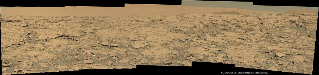
The view is getting stunninger and stunninger (for one as easily stunned as me). Here are Jan's two latest panoramas in circular form.
Phil sol 1828:
Sol 1829:
-------------------- ... because the Solar System ain't gonna map itself.
Also to be found posting similar content on https://mastodon.social/@PhilStooke Maps for download (free PD: https://upload.wikimedia.org/wikipedia/comm...Cartography.pdf NOTE: everything created by me which I post on UMSF is considered to be in the public domain (NOT CC, public domain) |
||
|
|
|
||
|
Sep 29 2017, 02:32 PM
Post
#50
|
||
|
Senior Member Group: Members Posts: 2833 Joined: 22-April 05 From: Ridderkerk, Netherlands Member No.: 353 |
The Navcam L view on Sol 1830.
Jan van Driel
|
|
|
|
|
|
|
Sep 29 2017, 03:55 PM
Post
#51
|
||
|
Solar System Cartographer Group: Members Posts: 10166 Joined: 5-April 05 From: Canada Member No.: 227 |
Very nice! Here it is in circular form.
Phil
-------------------- ... because the Solar System ain't gonna map itself.
Also to be found posting similar content on https://mastodon.social/@PhilStooke Maps for download (free PD: https://upload.wikimedia.org/wikipedia/comm...Cartography.pdf NOTE: everything created by me which I post on UMSF is considered to be in the public domain (NOT CC, public domain) |
|
|
|
|
|
|
Sep 29 2017, 04:10 PM
Post
#52
|
|
|
Senior Member Group: Members Posts: 1074 Joined: 21-September 07 From: Québec, Canada Member No.: 3908 |
The sol 1829 Lmastcam drive direction view:
|
|
|
|
|
Sep 30 2017, 03:27 AM
Post
#53
|
|
|
Senior Member Group: Members Posts: 1044 Joined: 17-February 09 Member No.: 4605 |
Probably a superb image Charborob, but unfortunately Flic.kr is yet again declining to play.
|
|
|
|
|
Sep 30 2017, 03:59 AM
Post
#54
|
||
|
Senior Member Group: Members Posts: 2429 Joined: 30-January 13 From: Penang, Malaysia. Member No.: 6853 |
QUOTE (serpens @ Sep 30 2017, 11:27 AM) Probably a superb image Charborob, but unfortunately Flic.kr is yet again declining to play. A roughly assembled version of the same images, but using a different projection than Charborob (assembled using MS ICE, with no additional processing)
|
|
|
|
|
|
|
Sep 30 2017, 04:19 PM
Post
#55
|
|
|
Senior Member Group: Members Posts: 1074 Joined: 21-September 07 From: Québec, Canada Member No.: 3908 |
QUOTE (serpens @ Sep 29 2017, 10:27 PM) Probably a superb image Charborob, but unfortunately Flic.kr is yet again declining to play. Don't know what the problem could be. Il works for me when I click on the image. |
|
|
|
|
Sep 30 2017, 05:25 PM
Post
#56
|
||
|
Senior Member Group: Members Posts: 1074 Joined: 21-September 07 From: Québec, Canada Member No.: 3908 |
Sol 1830 Lmastcam view (compressed):
and the Flickr link: https://flic.kr/p/YVSHPw (hope this works) |
|
|
|
|
|
|
Sep 30 2017, 11:22 PM
Post
#57
|
||||
|
Senior Member Group: Members Posts: 2429 Joined: 30-January 13 From: Penang, Malaysia. Member No.: 6853 |
A pair of rather interesting ChemCam Targets from sol 1831, shown in context on a resized version of the L-MastCam workspace from 1830
The mission update refers to them as "Normandien," and "Black Reef." Besides the interesting shapes, any thoughts on the small surface pits?
|
|||
|
|
|
|||
|
Oct 1 2017, 02:51 AM
Post
#58
|
|
|
Senior Member Group: Members Posts: 1044 Joined: 17-February 09 Member No.: 4605 |
QUOTE (PaulH51 @ Sep 30 2017, 03:59 AM) A roughly assembled version of the same images, but using a different projection than Charborob (assembled using MS ICE, with no additional processing) Beautiful Paul (both the image quality and the view). Thank you. |
|
|
|
|
Oct 1 2017, 09:59 AM
Post
#59
|
|
|
Merciless Robot Group: Admin Posts: 8784 Joined: 8-December 05 From: Los Angeles Member No.: 602 |
Strange little beasts. Normandien appears to be shot through with crack-filling intrusions of white material, so possibly metamorphized. The pits may have been inclusions of some other mineral that either evaporated out during the metamorphism or eroded away after the rock reached the surface.
(Sheer guesses; let's see what the real geologists say. )
-------------------- A few will take this knowledge and use this power of a dream realized as a force for change, an impetus for further discovery to make less ancient dreams real.
|
|
|
|
|
Oct 1 2017, 09:40 PM
Post
#60
|
||
|
Member Group: Members Posts: 684 Joined: 24-July 15 Member No.: 7619 |
QUOTE (PaulH51 @ Oct 1 2017, 12:22 AM) Besides the interesting shapes, any thoughts on the small surface pits?
I've seen voids like that in red mudstone, usually casts of carbonate or salt crystals that later dissolved. Hmm, micro-kettles when the loss inclusions salt, water ice or dry ice create voids? What sort of stability do water ice or dry ice have at the guesstimated deposition temperatures and pressures? |
|
|
|
|
|
|
Oct 1 2017, 10:33 PM
Post
#61
|
|
|
Senior Member Group: Members Posts: 1044 Joined: 17-February 09 Member No.: 4605 |
I think we need to wait and see what this little fellow is made of. While there may have been a few kilometres of sedimentary material covering this area in the past there would not be anywhere near the heat or pressure necessary for metamorphism. Could the apparent veining on the sunlit side be an artefact of reflectance?
|
|
|
|
|
Oct 2 2017, 12:49 AM
Post
#62
|
|||
|
Senior Member Group: Members Posts: 2429 Joined: 30-January 13 From: Penang, Malaysia. Member No.: 6853 |
QUOTE (serpens @ Oct 2 2017, 06:33 AM) I think we need to wait and see what this little fellow is made of.... We now have the R-MastCam frames of the two interesting 1831 ChemCam targets:
|
||
|
|
|
||
|
Oct 2 2017, 01:43 AM
Post
#63
|
|
|
Senior Member Group: Members Posts: 1044 Joined: 17-February 09 Member No.: 4605 |
Given that we are still on a slope climbing towards the top of the ridge and these probably bounced down from a higher level, it wouldn't surprise to find that "Black Reef" is a chip off the old block so to speak.
|
|
|
|
|
Oct 2 2017, 07:18 PM
Post
#64
|
|
 Member Group: Members Posts: 334 Joined: 11-December 12 From: The home of Corby Crater (Corby-England) Member No.: 6783 |
Only two in the immediate vicinity? If they were tumbling from above, wouldn't there be more? Having said that I don't know what "the immediate vicinity" is . Certainly seems to me to be out of context with their current location, very interesting that one seems to be a 'longer baked, bigger version, more developed', call it what you will, version of the other. Perhaps one arrived at it's current location long before the other?
Geology....madness solidified, I don't know how you do it! |
|
|
|
|
Oct 2 2017, 11:41 PM
Post
#65
|
|
|
Member Group: Members Posts: 684 Joined: 24-July 15 Member No.: 7619 |
QUOTE (serpens @ Oct 2 2017, 01:43 AM) Given that we are still on a slope climbing towards the top of the ridge and these probably bounced down from a higher level, it wouldn't surprise to find that "Black Reef" is a chip off the old block so to speak. "Architecture is solid music" - von Goethe "Geology is solid climatology" - me |
|
|
|
|
Oct 3 2017, 12:00 AM
Post
#66
|
||
|
Senior Member Group: Members Posts: 1044 Joined: 17-February 09 Member No.: 4605 |
I would amend that to read " Sedimentary geology is solid climatology" - you.
I was in fact mulling over the possibility that "Black Reef" parted from "Normandien" on the way down, along a fracture. We have seen a few instances of this with float. For example, this three piece jigsaw.
Attached thumbnail(s)
|
|
|
|
|
|
|
Oct 3 2017, 06:14 AM
Post
#67
|
||
|
Senior Member Group: Members Posts: 2429 Joined: 30-January 13 From: Penang, Malaysia. Member No.: 6853 |
Arm/drill issues after placing a sample from Ogunquit Beach in CheMin prevented the drive on sol 1833. That presented an opportunity to take another look at Normandien with ChemCam in Passive mode. It also meant the rover acquired a set of NavCam images with the arm extended
MS ICE managed to assemble these three frames. 'Curiosity looking back at its path', I hope others will properly assemble these.
|
|
|
|
|
|
|
Oct 3 2017, 07:03 AM
Post
#68
|
|
|
Senior Member Group: Members Posts: 2346 Joined: 7-December 12 Member No.: 6780 |
QUOTE (PaulH51 @ Oct 2 2017, 02:49 AM) We now have the R-MastCam frames of the two interesting 1831 ChemCam targets: ... To my limited geological experience, this looks remotely reminiscent of eroded stalagmites. Clay-loaded cool liquid dropping on a warmer ground would dry rapidly, form uneven layers, and might form small drying bubbles by outgassing or boiling. As usual in hugely underdetermined data sets, that's just one of an arbitrary number of options. |
|
|
|
|
Oct 3 2017, 10:26 AM
Post
#69
|
|
|
Solar System Cartographer Group: Members Posts: 10166 Joined: 5-April 05 From: Canada Member No.: 227 |
To add to the range of possibilities... it was suggested that these rocks fell down the slope from higher layers, but I would point out an alternative direction of movement - impact ejecta thrown up from the plains to the north, or even from much further afield. If the material was impact melt, solidifying in flight, the holes might be vesicles (bubbles). Not saying it has to be that, I just want to add to the confusion.
Phil -------------------- ... because the Solar System ain't gonna map itself.
Also to be found posting similar content on https://mastodon.social/@PhilStooke Maps for download (free PD: https://upload.wikimedia.org/wikipedia/comm...Cartography.pdf NOTE: everything created by me which I post on UMSF is considered to be in the public domain (NOT CC, public domain) |
|
|
|
|
Oct 3 2017, 01:51 PM
Post
#70
|
||
|
Senior Member Group: Members Posts: 2833 Joined: 22-April 05 From: Ridderkerk, Netherlands Member No.: 353 |
The Navcam L view on Sol 1833.
Jan van Driel
|
|
|
|
|
|
|
Oct 4 2017, 01:09 AM
Post
#71
|
||
|
Senior Member Group: Members Posts: 2429 Joined: 30-January 13 From: Penang, Malaysia. Member No.: 6853 |
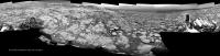
Drive of approximately 13.9m SSE (147º) on Sol 1834 (Oct 3, 2017) LINK
Very roughly processed and roughly stitched partial pan assembled in MS ICE using the L-NavCam's... Poor processing, but a great view
|
|
|
|
|
|
|
Oct 4 2017, 03:10 PM
Post
#72
|
||
|
Solar System Cartographer Group: Members Posts: 10166 Joined: 5-April 05 From: Canada Member No.: 227 |
Sol 1834 Hazcams reprojected to find the location after the drive - not always good enough, but today they work just fine.
Phil PS I just spent an enjoyable afternoon with ngunn, a very nice chat about all things UMSF.
-------------------- ... because the Solar System ain't gonna map itself.
Also to be found posting similar content on https://mastodon.social/@PhilStooke Maps for download (free PD: https://upload.wikimedia.org/wikipedia/comm...Cartography.pdf NOTE: everything created by me which I post on UMSF is considered to be in the public domain (NOT CC, public domain) |
|
|
|
|
|
|
Oct 4 2017, 03:10 PM
Post
#73
|
||
|
Senior Member Group: Members Posts: 2833 Joined: 22-April 05 From: Ridderkerk, Netherlands Member No.: 353 |
The Navcam L view on Sol 1834.
Jan van Driel
|
|
|
|
|
|
|
Oct 4 2017, 07:29 PM
Post
#74
|
||
 Senior Member Group: Members Posts: 1088 Joined: 19-February 05 From: Close to Meudon Observatory in France Member No.: 172 |
On the latest NavCam pics, and due to the low opacity of the Martian atmosphere and our climbing the hills, we are beginning to see clearly some far horizon features (herewith a Sol 1834 pic).
Dear Phil, as our talented Cartographer-in-Chief, could you please give us your opinion with a location on a map ? Thanks so much in advance
|
|
|
|
|
|
|
Oct 4 2017, 08:13 PM
Post
#75
|
|
 Senior Member Group: Members Posts: 4247 Joined: 17-January 05 Member No.: 152 |
Those look like the same features Phil identified in this post.
|
|
|
|
|
Oct 5 2017, 07:01 AM
Post
#76
|
|
|
Senior Member Group: Members Posts: 1088 Joined: 19-February 05 From: Close to Meudon Observatory in France Member No.: 172 |
QUOTE (fredk @ Oct 4 2017, 10:13 PM) Those look like the same features Phil identified in this post. Thanks a lot fredk for the link... and also to Phil for his good map |
|
|
|
|
Oct 5 2017, 07:23 AM
Post
#77
|
||
|
Senior Member Group: Members Posts: 2429 Joined: 30-January 13 From: Penang, Malaysia. Member No.: 6853 |
Sol 1834 L-MastCam Arm Workspace (Raw in MS ICE)
|
|
|
|
|
|
|
Oct 5 2017, 09:49 AM
Post
#78
|
||
|
Senior Member Group: Members Posts: 2833 Joined: 22-April 05 From: Ridderkerk, Netherlands Member No.: 353 |
The Navcam L view on Sol 1834. (Added 1 Right Navcam image)
Jan van Driel
|
|
|
|
|
|
|
Oct 5 2017, 11:21 AM
Post
#79
|
|
|
Senior Member Group: Members Posts: 1074 Joined: 21-September 07 From: Québec, Canada Member No.: 3908 |
Sol 1834 Lmastcam view:
|
|
|
|
|
Oct 6 2017, 12:47 PM
Post
#80
|
|||
|
Senior Member Group: Members Posts: 2429 Joined: 30-January 13 From: Penang, Malaysia. Member No.: 6853 |
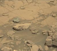
One of sol 1836 DRT targets has some lighter toned areas within the brushed zone (not the calcium sulfate veins). I thought maybe these were DRT scouring on the high spots on a soft rock target, however another MAHLI of the same target after the LIBS array, but prior to the DRT appears to show some of the light toned areas may have been present before the DRT brushed the target. The raw images are attached. One of the LIBS sites may have hit the edge of a light toned area, so it may be interesting to review the spectra once released
Links to raw images Link_1 - Link_2 |
||
|
|
|
||
|
Oct 7 2017, 07:57 PM
Post
#81
|
||
|
Member Group: Members Posts: 293 Joined: 22-September 08 From: Spain Member No.: 4350 |
I think she's getting a bit creative with her ChemCam laser.

|
|
|
|
|
|
|
Oct 8 2017, 12:02 PM
Post
#82
|
||
|
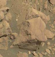
Senior Member Group: Members Posts: 1044 Joined: 17-February 09 Member No.: 4605 |
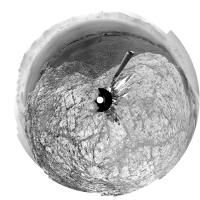
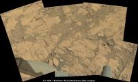
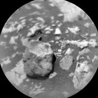
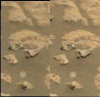
Now this is interesting. Reduction spots in hematite rich sandstone, with the lack of sphericity probably indicating formation pre-compaction. I don't know if it is possible to get any indication of the mineral in the cores but some of the possibilities are fascinating.
Attached thumbnail(s)
|
|
|
|
|
|
|
Oct 8 2017, 02:50 PM
Post
#83
|
|
 Member Group: Members Posts: 810 Joined: 3-June 04 From: Brittany, France Member No.: 79 |
My take on the beautiful MC34 panorama of sol 1812, while climbing the ramp to top:
 And panorama taken with NavCam Left on sol 1833 patched with pictures taken on sol 1834, with a sky adapted from scalbers' work: 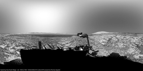 You can explore it in Virtual Reality here on Round Me. Does someone know a sol where the rover would have taken a picture of its turret in the same orientation as on sol 1833? So that I can fill the part not imaged on sol 1833... -------------------- |
|
|
|
|
Oct 8 2017, 03:41 PM
Post
#84
|
||
|
Senior Member Group: Members Posts: 2833 Joined: 22-April 05 From: Ridderkerk, Netherlands Member No.: 353 |
The Navcam L view on Sol 1837.
Jan van Driel
|
|
|
|
|
|
|
Oct 8 2017, 07:26 PM
Post
#85
|
|
|
Member Group: Members Posts: 810 Joined: 3-June 04 From: Brittany, France Member No.: 79 |
Mosaic of pictures taken with MC34 on sol 1830 and 1834. Top of the hills were patched with pictures of sol 1829. I'm looking forward to a panorama taken with MC100 !

-------------------- |
|
|
|
|
Oct 9 2017, 11:29 AM
Post
#86
|
|||
|
Solar System Cartographer Group: Members Posts: 10166 Joined: 5-April 05 From: Canada Member No.: 227 |
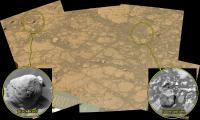
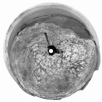
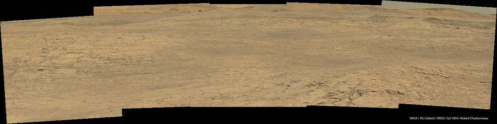
Jan's last two panoramas in circular form. They really help to give the impression of driving across this elevated and pitted surface.
Phil Sol 1834:
Sol 1837:
-------------------- ... because the Solar System ain't gonna map itself.
Also to be found posting similar content on https://mastodon.social/@PhilStooke Maps for download (free PD: https://upload.wikimedia.org/wikipedia/comm...Cartography.pdf NOTE: everything created by me which I post on UMSF is considered to be in the public domain (NOT CC, public domain) |
||
|
|
|
||
|
Oct 9 2017, 07:25 PM
Post
#87
|
|
|
Senior Member Group: Members Posts: 1074 Joined: 21-September 07 From: Québec, Canada Member No.: 3908 |
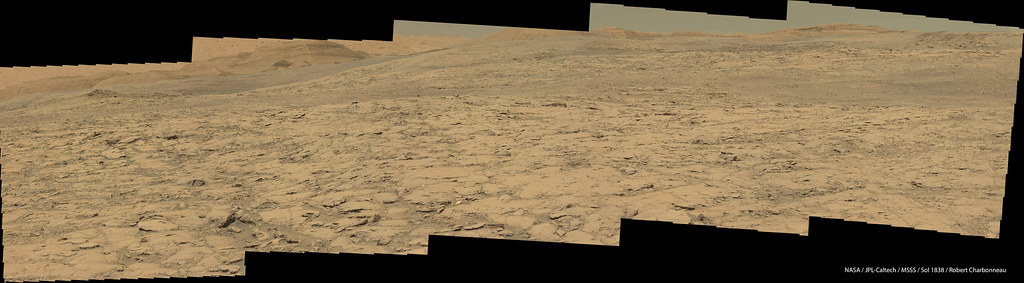
Sol 1838 Lmastcam view:
|
|
|
|
|
Oct 10 2017, 06:33 AM
Post
#88
|
|
|
Senior Member Group: Members Posts: 1044 Joined: 17-February 09 Member No.: 4605 |
QUOTE (serpens @ Oct 8 2017, 01:02 PM) Reduction spots in hematite rich sandstone.... Heck, what I thought looked like redox controlled mineralisation turns out to be laser shots. |
|
|
|
|
Oct 10 2017, 11:57 AM
Post
#89
|
|
|
Senior Member Group: Members Posts: 2429 Joined: 30-January 13 From: Penang, Malaysia. Member No.: 6853 |
QUOTE (serpens @ Oct 10 2017, 02:33 PM) ....turns out to be laser shots. They did go in very close for that image |
|
|
|
|
Oct 10 2017, 09:58 PM
Post
#90
|
||
|
Senior Member Group: Members Posts: 1044 Joined: 17-February 09 Member No.: 4605 |
I was the two so close together, particularly with the bright pixel that threw me.

Attached thumbnail(s)
|
|
|
|
|
|
|
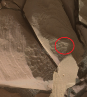
Oct 12 2017, 08:45 PM
Post
#91
|
||||
|
Member Group: Members Posts: 866 Joined: 15-March 05 From: Santa Cruz, CA Member No.: 196 |
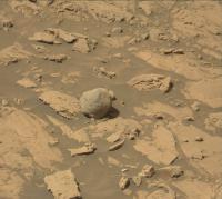
exhumed meteorite fragment or specular deception? m34/m100 cross anaglyph and detail in parellel view, but clearest view in the sol1847 original
Actually made me think of that 'italy' prong way back at yellowknife(discussion), which looking back was probably a meteorite fragment still embedded.
|
|||
|
|
|
|||
|
Oct 13 2017, 09:40 AM
Post
#92
|
|
|
Solar System Cartographer Group: Members Posts: 10166 Joined: 5-April 05 From: Canada Member No.: 227 |
A small move on sol 1843... but just a turn in place, I think. If it was intended, it may be to reach an interesting target with the arm. Otherwise it might be an aborted drive. No map update for this.
Phil -------------------- ... because the Solar System ain't gonna map itself.
Also to be found posting similar content on https://mastodon.social/@PhilStooke Maps for download (free PD: https://upload.wikimedia.org/wikipedia/comm...Cartography.pdf NOTE: everything created by me which I post on UMSF is considered to be in the public domain (NOT CC, public domain) |
|
|
|
|
Oct 14 2017, 12:32 AM
Post
#93
|
|
|
Member Group: Admin Posts: 976 Joined: 29-September 06 From: Pasadena, CA - USA Member No.: 1200 |
QUOTE (Phil Stooke @ Oct 13 2017, 01:40 AM) A small move on sol 1843... but just a turn in place, I think. If it was intended, it may be to reach an interesting target with the arm. Otherwise it might be an aborted drive. No map update for this. Phil It was an aborted drive. Not sure about the details since I was out of the office today but saw the fault on my email update. Paolo -------------------- Disclaimer: all opinions, ideas and information included here are my own,and should not be intended to represent opinion or policy of my employer.
|
|
|
|
|
Oct 16 2017, 04:10 PM
Post
#94
|
|
|
Founder Group: Chairman Posts: 14432 Joined: 8-February 04 Member No.: 1 |
Here's a cheat for those following along at home. Every day there is a drive or robotic arm stuff planned, ECAM delivers a sequence called FHAZ00190
It's an off-nominal image - if something happens that causes a drive to abort early or an arm sequence to stop unexpectedly....then FHAZ00190 gets taken. Such as https://mars.jpl.nasa.gov/msl/multimedia/ra...90M_&s=1839 If it's a drive - quite often - the rest of the post drive imaging will still occurs such as a normal end of drive FHAZ, RHAZ and series of NavCam sequences - which is why there's an FHAZ00337 taken shortly afterwards.. https://mars.jpl.nasa.gov/msl/multimedia/ra...37M_&s=1839 |
|
|
|
|
Oct 16 2017, 07:55 PM
Post
#95
|
||
|
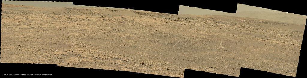
Senior Member Group: Members Posts: 2833 Joined: 22-April 05 From: Ridderkerk, Netherlands Member No.: 353 |
The Navcam L view on Sol 1846.
Jan van Driel
|
|
|
|
|
|
|
Oct 17 2017, 04:19 PM
Post
#96
|
||
|
Solar System Cartographer Group: Members Posts: 10166 Joined: 5-April 05 From: Canada Member No.: 227 |
Thanks, Jan. Here is your panorama in circular form. Moving along the ridge a bit. A map update will follow shortly.
Phil
-------------------- ... because the Solar System ain't gonna map itself.
Also to be found posting similar content on https://mastodon.social/@PhilStooke Maps for download (free PD: https://upload.wikimedia.org/wikipedia/comm...Cartography.pdf NOTE: everything created by me which I post on UMSF is considered to be in the public domain (NOT CC, public domain) |
|
|
|
|
|
|
Oct 17 2017, 05:32 PM
Post
#97
|
|
|
Senior Member Group: Members Posts: 1074 Joined: 21-September 07 From: Québec, Canada Member No.: 3908 |
The sol 1846 Lmastcam drive direction view:
 And a view of the nearby rocks: 
|
|
|
|
|
Oct 20 2017, 12:34 AM
Post
#98
|
||
|
Senior Member Group: Members Posts: 2429 Joined: 30-January 13 From: Penang, Malaysia. Member No.: 6853 |
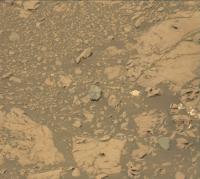
gravelly workspace on the ridge (L-MastCam raw in MS ICE)
|
|
|
|
|
|
|
Oct 20 2017, 05:10 AM
Post
#99
|
||
|
Senior Member Group: Members Posts: 2429 Joined: 30-January 13 From: Penang, Malaysia. Member No.: 6853 |
Roughly assembled sol 1850 L-NavCam post-drive partial pan assembled in MS ICE, raw, no additional processing.
Take Curiosity away from the gravel patch, and onto a potential drill test site? (Feed-extended drilling)
|
|
|
|
|
|
|
Oct 20 2017, 09:46 AM
Post
#100
|
||
|
Member Group: Members Posts: 684 Joined: 24-July 15 Member No.: 7619 |
QUOTE (PaulH51 @ Oct 20 2017, 01:34 AM) gravelly workspace on the ridge (L-MastCam raw in MS ICE)
Could be the mind wanting to see patterns, pareidolia, but there seem to be several linear or rippled features in those pebbles... Wonder if CO2 frosts and dunes can churn martian soil the same way freeze thaw does on earth... |
|
|
|
|
|
|

|
Lo-Fi Version | Time is now: 23rd May 2024 - 04:06 AM |
|
RULES AND GUIDELINES Please read the Forum Rules and Guidelines before posting. IMAGE COPYRIGHT |
OPINIONS AND MODERATION Opinions expressed on UnmannedSpaceflight.com are those of the individual posters and do not necessarily reflect the opinions of UnmannedSpaceflight.com or The Planetary Society. The all-volunteer UnmannedSpaceflight.com moderation team is wholly independent of The Planetary Society. The Planetary Society has no influence over decisions made by the UnmannedSpaceflight.com moderators. |
SUPPORT THE FORUM Unmannedspaceflight.com is funded by the Planetary Society. Please consider supporting our work and many other projects by donating to the Society or becoming a member. |
|