Marathon Valley, Sol 4078-4481 (July 15, 2015 - September 1, 2016) |

Marathon Valley, Sol 4078-4481 (July 15, 2015 - September 1, 2016) |
 Jul 15 2015, 01:54 PM Jul 15 2015, 01:54 PM
Post
#1
|
|
 Senior Member  Group: Members Posts: 4250 Joined: 17-January 05 Member No.: 152 |
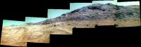
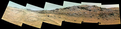
It looks like we had a pretty good drive on 4078 roughly to the east (or NE) and now have a better view down into Marathon Valley:
http://qt.exploratorium.edu/mars/opportuni...0M1.JPG?sol4078 (Yes, we are still paying attention, Oppy!) |
 |
 
|
 |
|
Aug 11 2015, 10:11 PM
Post
#46
|
|
|
Senior Member Group: Members Posts: 3516 Joined: 4-November 05 From: North Wales Member No.: 542 |
Oops - I thought the previous one was an anaglyph because it has coloured fringes on the skyline. Anyway both are much appreciated.
|
|
|
|
|
Aug 12 2015, 06:43 PM
Post
#47
|
|
 Member Group: Members Posts: 334 Joined: 11-December 12 From: The home of Corby Crater (Corby-England) Member No.: 6783 |
Now that's exactly what I meant by somebody else making a better job of it!!

|
|
|
|
|
Aug 16 2015, 07:07 PM
Post
#48
|
||
|
Member Group: Members Posts: 334 Joined: 11-December 12 From: The home of Corby Crater (Corby-England) Member No.: 6783 |
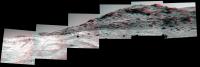
PanCam views of the other wall (North facing I believe) of Marathon valley on Sol 4108
|
|
|
|
|
|
|
Aug 16 2015, 07:09 PM
Post
#49
|
||
|
Member Group: Members Posts: 334 Joined: 11-December 12 From: The home of Corby Crater (Corby-England) Member No.: 6783 |
And as an anaglyph.
|
|
|
|
|
|
|
Aug 16 2015, 09:29 PM
Post
#50
|
|
|
Senior Member Group: Members Posts: 3516 Joined: 4-November 05 From: North Wales Member No.: 542 |
Very nice! Can anyone shed light on whether these are depositional layers, parallel erosion surfaces or something else?
|
|
|
|
|
Aug 19 2015, 07:31 AM
Post
#51
|
|
 Member Group: Members Posts: 146 Joined: 22-November 14 From: Bormida (SV) - Italy Member No.: 7348 |
Mosaic sol 1408
 and HazCam in color, left and right, sol 4107 (using the variations of light as filters) 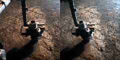
-------------------- |
|
|
|
|
Aug 19 2015, 07:36 PM
Post
#52
|
|
 Senior Member Group: Members Posts: 1089 Joined: 19-February 05 From: Close to Meudon Observatory in France Member No.: 172 |
QUOTE (eliBonora @ Aug 19 2015, 09:31 AM)  Mosaic sol 1408 WOW ! Thanks a lot eliBonora for sharing this nice work of yours ! 
|
|
|
|
|
Aug 19 2015, 11:42 PM
Post
#53
|
|||
|
Member Group: Members Posts: 866 Joined: 15-March 05 From: Santa Cruz, CA Member No.: 196 |
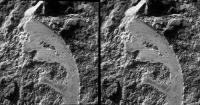
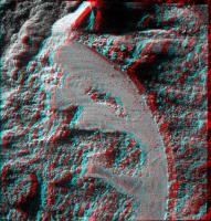
yes nice treatment! the parellel slightly exceeds my interpupilary distance on my monitor, making that one challenging but i am finding that its indeed possible to train the eyes to diverge unnaturally. Here are a crosseye and anaglyph of the brushing (09 CCW rotated).
|
||
|
|
|
||
|
Aug 24 2015, 08:51 PM
Post
#54
|
||
|
Member Group: Members Posts: 866 Joined: 15-March 05 From: Santa Cruz, CA Member No.: 196 |
sol4117 marathon boulders at dusk
|
|
|
|
|
|
|
Aug 27 2015, 04:13 PM
Post
#55
|
|
|
Senior Member Group: Members Posts: 4250 Joined: 17-January 05 Member No.: 152 |
It looks like we may be heading into those boulders next, according to Crumpler's blog.
|
|
|
|
|
Aug 27 2015, 07:18 PM
Post
#56
|
|
|
Member Group: Members Posts: 866 Joined: 15-March 05 From: Santa Cruz, CA Member No.: 196 |
..Crumpler curiously calls them "dark float rocks", or perhaps that's just a parcel of geologic nomenclature.. i'm inferring they haven't yet definitively spotted smectite from pancam data and are relying on low res orbital data and best hunches to pick the prospective targets to get a profile.. here's Larry's rendering in native resolution:

|
|
|
|
|
Aug 27 2015, 07:42 PM
Post
#57
|
|
 Administrator Group: Admin Posts: 5172 Joined: 4-August 05 From: Pasadena, CA, USA, Earth Member No.: 454 |
"Float" is a term for rocks that have broken from their source rock, so they're no longer in place; they lack context (except that they probably originated upslope). Geologists prefer to analyze bedrock rather than float when they can, but the rovers are often forced to look at float rocks rather than outcrop higher up because of terrain trafficability issues. What they do try to do is find float that hasn't traveled far, where you can see the scar that it left behind on the outcrop so you be reasonably sure you know its initial position and orientation.
-------------------- My website - My Patreon - @elakdawalla on Twitter - Please support unmannedspaceflight.com by donating here.
|
|
|
|
|
Aug 27 2015, 09:43 PM
Post
#58
|
|
 Senior Member Group: Members Posts: 2173 Joined: 28-December 04 From: Florida, USA Member No.: 132 |
I was surprised to see that the area of smectite detection by CRISM shown in Crumpler's blog encompasses the floor of the valley almost to the exclusion of the bordering layers of bedrock. But maybe the resolution is such that a distinction cannot be made and the outline around the valley floor is misleading if taken as a hard fact.
|
|
|
|
|
Aug 27 2015, 09:53 PM
Post
#59
|
|
|
Senior Member Group: Members Posts: 3516 Joined: 4-November 05 From: North Wales Member No.: 542 |
Larry Crumpler's field reports are always very informative but this one excels in the amount of information in the illustrations. We even have the angles of dip in the foliations within the rocks in view. Foliation, if I'm not msitaken, is a word for layers in rocks where it seems unlikely that they're sedimentary layers.
|
|
|
|
|
Sep 9 2015, 12:53 AM
Post
#60
|
|
|
Member Group: Members Posts: 911 Joined: 4-September 06 From: Boston Member No.: 1102 |
Opportunity is still alive and exploring Marathon Valley. Seems like UMSF has sort of ignored her for the past two weeks.
The monthly report by A.J.S. Rayl came out 9/3 Link -------------------- |
|
|
|
 |

|
Lo-Fi Version | Time is now: 3rd June 2024 - 09:52 PM |
|
RULES AND GUIDELINES Please read the Forum Rules and Guidelines before posting. IMAGE COPYRIGHT |
OPINIONS AND MODERATION Opinions expressed on UnmannedSpaceflight.com are those of the individual posters and do not necessarily reflect the opinions of UnmannedSpaceflight.com or The Planetary Society. The all-volunteer UnmannedSpaceflight.com moderation team is wholly independent of The Planetary Society. The Planetary Society has no influence over decisions made by the UnmannedSpaceflight.com moderators. |
SUPPORT THE FORUM Unmannedspaceflight.com is funded by the Planetary Society. Please consider supporting our work and many other projects by donating to the Society or becoming a member. |
|