Dawn data in the PDS |

Dawn data in the PDS |
 Feb 15 2012, 12:55 AM Feb 15 2012, 12:55 AM
Post
#1
|
|
 Administrator  Group: Admin Posts: 5172 Joined: 4-August 05 From: Pasadena, CA, USA, Earth Member No.: 454 |
Hey folks, Christmas came just a little bit late this year...
http://dawnpub.igpp.ucla.edu QUOTE DAWN DATA RELEASE: LEVEL 1A DATA FROM APPROACH AND SURVEY It is a LOT of data. Just the Vesta Approach includes about 2000 FC images! Wow!!!The Dawn project has created a public website that is available to serve the cruise and Vesta data sets that have been delivered to the Planetary Data System (PDS) while the data are still under review. Data are available from all three Dawn instruments, the Framing Camera (FC), the Visual and Infrared Mapping Spectrometer (VIR), and the Gamma Ray and Neutron Detector (GRaND). The data that are currently available are raw data, in engineering units, sometimes referred to as EDRs by the PDS or as NASA level-1a data. Additional data sets will be added when they are submitted to the PDS. The Dawn website is located at: http://dawnpub.igpp.ucla.edu Users of these data should exercise caution. Invariably there will be errors or omissions in the documentation. Please report any problems... I think that the first thing I'm going to work on is that approach sequence/movie that I wish I'd had in real time. The rotation of Vesta through the image sequences makes color composition very hard, but I am sure there are people here who are up to it. I hope someone here can come up with a pretty color global shot that I can put into a comparison montage! -------------------- My website - My Patreon - @elakdawalla on Twitter - Please support unmannedspaceflight.com by donating here.
|
 |
 
|
 |
|
Feb 15 2012, 06:16 AM
Post
#2
|
|
|
Administrator Group: Admin Posts: 5172 Joined: 4-August 05 From: Pasadena, CA, USA, Earth Member No.: 454 |
I'm so excited about this data that I'm breaking my usual prohibition against posting links to my own blog entries. Dawn approaches Vesta, how I wanted it to happen!
-------------------- My website - My Patreon - @elakdawalla on Twitter - Please support unmannedspaceflight.com by donating here.
|
|
|
|
|
Feb 15 2012, 06:38 AM
Post
#3
|
|
|
Administrator Group: Admin Posts: 5172 Joined: 4-August 05 From: Pasadena, CA, USA, Earth Member No.: 454 |
(Sorry if I am talking to my self here. I hope it's only because other folks are asleep or haven't downloaded the data yet.) The one thing I'm still scratching my head about is that it doesn't seem they ever shot a multi-frame mosaic quickly enough to avoid Vesta rotating underneath them, at least not that I've found yet. (I hope someone will tell me I overlooked something.) There seems to be absolutely no way to make a high-resolution global mosaic without reprojecting images to compensate for rotation; and with Vesta being as lumpy as it is, that requires a good shape model and some code. The final set of images taken before the start of the Survey mission is called "mosaic" but it seems to have recorded a full rotation of Vesta with the spacecraft sweeping back and forth along a line of longitude, taking three frames to cover Vesta from north to south, letting it rotate underneath Dawn. It is perfect for a global base map at constant illumination geometry, but I can't get my high-res global view. I want my high-res global view!
-------------------- My website - My Patreon - @elakdawalla on Twitter - Please support unmannedspaceflight.com by donating here.
|
|
|
|
|
Feb 15 2012, 10:22 AM
Post
#4
|
|
 Senior Member Group: Admin Posts: 3108 Joined: 21-December 05 From: Canberra, Australia Member No.: 615 |
Awesome work Emily.
With the images and animation you have posted so far, it kinda proves that we were right to I only wish I had some idea of how to process these files. Tutorial references please 
|
|
|
|
|
Feb 15 2012, 11:19 AM
Post
#5
|
|
 The Poet Dude Group: Moderator Posts: 5551 Joined: 15-March 04 From: Kendal, Cumbria, UK Member No.: 60 |
QUOTE (elakdawalla @ Feb 15 2012, 06:16 AM)  I'm so excited about this data that I'm breaking my usual prohibition against posting links to my own blog entries. Dawn approaches Vesta, how I wanted it to happen! Emily, none of us would mind if you did that more often, honestly! I'm sure new members especially would welcome it if you let UMSF know when you'd written something you think people might find interesting. I think we forget sometimes that new people find UMSF, and take up an interest in space exploration, every day, so we shouldn't assume everyone reading UMSF posts already knows the backgrounds of the posters. So if you want to post a link to something you've written, fire away! :_ -------------------- |
|
|
|
|
Feb 15 2012, 12:03 PM
Post
#6
|
|
 Member Group: Members Posts: 796 Joined: 27-February 08 From: Heart of Europe Member No.: 4057 |
I'm very happy with that data release, and your animation, Emily, is fantastic!
It's interesting, that Vesta looks in this animation somewhat crisper and better imaginable as real object than in first images (and animations) from approach phase published last year. "I'm so excited about this data that I'm breaking my usual prohibition against posting links to my own blog entries" I haven't problem with this as I often do the same thing  . .
-------------------- |
|
|
|
|
Feb 15 2012, 07:00 PM
Post
#7
|
|
|
Member Group: Members Posts: 102 Joined: 29-January 10 From: Poland Member No.: 5205 |
 now I see "This site is temporarily under construction" now I see "This site is temporarily under construction"-------------------- Adam Hurcewicz from Poland
|
|
|
|
|
Feb 15 2012, 08:01 PM
Post
#8
|
|
|
Member Group: Members Posts: 808 Joined: 10-October 06 From: Maynard Mass USA Member No.: 1241 |
Emily, nice animation!
-------------------- CLA CLL
|
|
|
|
|
Feb 15 2012, 10:04 PM
Post
#9
|
|
|
Administrator Group: Admin Posts: 5172 Joined: 4-August 05 From: Pasadena, CA, USA, Earth Member No.: 454 |
QUOTE (Adam Hurcewicz @ Feb 15 2012, 11:00 AM) now I see "This site is temporarily under construction"Hm. Me too. I haven't received any "cease and desist" style email though. I haven't had any more time to do more image processing today, unfortunately. -------------------- My website - My Patreon - @elakdawalla on Twitter - Please support unmannedspaceflight.com by donating here.
|
|
|
|
|
Feb 17 2012, 10:26 AM
Post
#10
|
|
|
Member Group: Members Posts: 102 Joined: 29-January 10 From: Poland Member No.: 5205 |
So where is this data ? Anyone knows ?
-------------------- Adam Hurcewicz from Poland
|
|
|
|
|
Feb 17 2012, 02:50 PM
Post
#11
|
|
|
Junior Member Group: Members Posts: 50 Joined: 27-June 11 From: Katlenburg-Lindau, Lower Saxony, Germany Member No.: 6038 |
Is it right to say that, if data has been publicly available at least once, it should always be?
I am sorry if this almost falls into the OT category, but I thought it might be worth discussing. If anyone disagrees, feel free to make yourself heard. -------------------- |
|
|
|
|
Feb 17 2012, 04:18 PM
Post
#12
|
|
|
Member Group: Members Posts: 910 Joined: 4-September 06 From: Boston Member No.: 1102 |
I doubt that anyone in this forum would say no.
You are being a bit cryptic. Has the data been removed? If so, for what reason? A different question: Would releasing data for a period of time and then removing it fulfil the mission's obligations for data release? I would guess no one here would say yes. -------------------- |
|
|
|
|
Feb 17 2012, 04:53 PM
Post
#13
|
|
|
Solar System Cartographer Group: Members Posts: 10166 Joined: 5-April 05 From: Canada Member No.: 227 |
The original link went into the data page, now it goes to the site's home page. It's most likely that it really is just 'under construction', still being developed, and that the proper link will be up and running soon.
Phil -------------------- ... because the Solar System ain't gonna map itself.
Also to be found posting similar content on https://mastodon.social/@PhilStooke Maps for download (free PD: https://upload.wikimedia.org/wikipedia/comm...Cartography.pdf NOTE: everything created by me which I post on UMSF is considered to be in the public domain (NOT CC, public domain) |
|
|
|
|
Feb 19 2012, 01:54 AM
Post
#14
|
|
|
Solar System Cartographer Group: Members Posts: 10166 Joined: 5-April 05 From: Canada Member No.: 227 |
Just noticed this at the PDS Small Bodies Node:
http://pds-smallbodies.astro.umd.edu/data_...ase_sched.shtml Some interesting things coming up... including the Dawn dates and Rosetta Lander Mars flyby data... Phil -------------------- ... because the Solar System ain't gonna map itself.
Also to be found posting similar content on https://mastodon.social/@PhilStooke Maps for download (free PD: https://upload.wikimedia.org/wikipedia/comm...Cartography.pdf NOTE: everything created by me which I post on UMSF is considered to be in the public domain (NOT CC, public domain) |
|
|
|
|
Feb 21 2012, 02:58 PM
Post
#15
|
|
|
Member Group: Members Posts: 235 Joined: 2-August 05 Member No.: 451 |
Including, that the Hayabasa imaging and v2 of the LIDAR has finally been released.
|
|
|
|
|
Apr 3 2012, 05:45 PM
Post
#16
|
|
|
Member Group: Members Posts: 796 Joined: 27-February 08 From: Heart of Europe Member No.: 4057 |
Does anyone know, what happened to Dawn's FC raw data? Data release was scheduled for 1.3.2012 (more than one month ago) and PDS is still empty. Some problems with calibrations or something similar?
-------------------- |
|
|
|
|
Apr 3 2012, 06:17 PM
Post
#17
|
|
|
Solar System Cartographer Group: Members Posts: 10166 Joined: 5-April 05 From: Canada Member No.: 227 |
No, much more complicated. There is a disagreement over certain aspects of the documentation and PDS will not ingest the data until the situation is resolved.
Phil Stooke -------------------- ... because the Solar System ain't gonna map itself.
Also to be found posting similar content on https://mastodon.social/@PhilStooke Maps for download (free PD: https://upload.wikimedia.org/wikipedia/comm...Cartography.pdf NOTE: everything created by me which I post on UMSF is considered to be in the public domain (NOT CC, public domain) |
|
|
|
|
Apr 3 2012, 06:37 PM
Post
#18
|
|
|
Member Group: Members Posts: 796 Joined: 27-February 08 From: Heart of Europe Member No.: 4057 |
Thanks for answering my question!
-------------------- |
|
|
|
|
Apr 3 2012, 11:08 PM
Post
#19
|
|
|
Administrator Group: Admin Posts: 5172 Joined: 4-August 05 From: Pasadena, CA, USA, Earth Member No.: 454 |
I talked with several scientists at LPSC about this and while we won't see it at the PDS any time soon, they all told me I should go ahead and play with the data and encourage others to do the same. I have all the released FC data. When I can find time to work with it I'll make chunks of it available. But we're in the middle of a complete site overhaul just now and I don't have time to play
-------------------- My website - My Patreon - @elakdawalla on Twitter - Please support unmannedspaceflight.com by donating here.
|
|
|
|
|
Apr 4 2012, 10:27 AM
Post
#20
|
|
|
Member Group: Members Posts: 796 Joined: 27-February 08 From: Heart of Europe Member No.: 4057 |
"When I can find time to work with it I'll make chunks of it available."
That would be nice! I have only few images from 11.8.2011. -------------------- |
|
|
|
|
Apr 28 2012, 11:47 AM
Post
#21
|
|
|
Junior Member Group: Members Posts: 22 Joined: 23-August 11 From: France Member No.: 6134 |
According to http://pds-smallbodies.astro.umd.edu/data_...ase_sched.shtml, it seems that we still have to wait only few days (Finally !?)
|
|
|
|
|
Apr 28 2012, 03:02 PM
Post
#22
|
|
|
Solar System Cartographer Group: Members Posts: 10166 Joined: 5-April 05 From: Canada Member No.: 227 |
May not be reliable. I don't think the underlying issue has been dealt with yet.
Phil -------------------- ... because the Solar System ain't gonna map itself.
Also to be found posting similar content on https://mastodon.social/@PhilStooke Maps for download (free PD: https://upload.wikimedia.org/wikipedia/comm...Cartography.pdf NOTE: everything created by me which I post on UMSF is considered to be in the public domain (NOT CC, public domain) |
|
|
|
|
Sep 11 2012, 12:44 AM
Post
#23
|
|
|
Newbie Group: Members Posts: 17 Joined: 24-August 12 Member No.: 6610 |
-------------------- Thomas Gold was probably right about a iceball Mars.....
|
|
|
|
|
Sep 21 2012, 09:39 PM
Post
#24
|
|
 Member Group: Members Posts: 495 Joined: 12-February 12 Member No.: 6336 |
Water on Vesta, that's a surprise.
Science daily And Nasa including one flash video file and the pitted terrain on the bottom of Marcia crater. |
|
|
|
|
Sep 21 2012, 10:08 PM
Post
#25
|
|
|
Senior Member Group: Members Posts: 3516 Joined: 4-November 05 From: North Wales Member No.: 542 |
I don't find it surprising. There's water ice almost everywhere except on exposed planetary surfaces. Plenty on Mars, over a wide range of latitudes. The next large objects are the Jovian moons. Only one is non-icy: the rest are mainly ice.
I think all the big asteroids will have a lot of ice, though mostly sub-surface. Apart from ice incorporated when they formed they may also have ice originating from later comet impacts. Visible ice may indicate nothing more than recent exposure. |
|
|
|
|
Sep 22 2012, 11:14 AM
Post
#26
|
|
 Senior Member Group: Members Posts: 1729 Joined: 3-August 06 From: 43° 35' 53" N 1° 26' 35" E Member No.: 1004 |
the original papers in Science Express:
Elemental Mapping by Dawn Reveals Exogenic H in Vesta's Regolith Pitted Terrain on Vesta and Implications for the Presence of Volatiles and a comment article also in Science Express A Golden Spike for Planetary Science |
|
|
|
|
Sep 22 2012, 12:49 PM
Post
#27
|
|
|
Senior Member Group: Members Posts: 3516 Joined: 4-November 05 From: North Wales Member No.: 542 |
Freely available Supplementary Materials from the 'Pitted Terrain' paper include lots of great images: http://www.sciencemag.org/content/suppl/20...1/Denevi.SM.pdf
|
|
|
|
|
Oct 31 2012, 07:35 PM
Post
#28
|
|
|
Senior Member Group: Members Posts: 1729 Joined: 3-August 06 From: 43° 35' 53" N 1° 26' 35" E Member No.: 1004 |
still more papers on Dawn at Vesta in today's Nature (sorry, I don't know whether this is the good topic):
Distinctive space weathering on Vesta from regolith mixing processes Dark material on Vesta from the infall of carbonaceous volatile-rich material |
|
|
|
|
Nov 15 2012, 01:20 AM
Post
#29
|
|||
|
Member Group: Members Posts: 796 Joined: 27-February 08 From: Heart of Europe Member No.: 4057 |
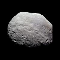
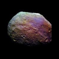
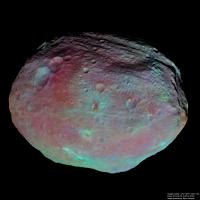
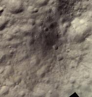
And now for something completely different - Dawn data in the PDS!
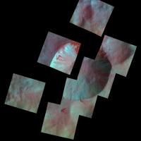
Few experiments from images FC21A0003204_11205081617F7K, FC21A0003199_11205081516F2K and FC21A0003205_11205081627F8K (all 24.7.2011) First image is with "normal" colors (I don't know how close is this to true colors, but its from filters closest to RGB standard). Second image is with saturated colors. All images are rotated 180° to the right, so Rheasilvia is on top.
Attached thumbnail(s)
-------------------- |
||
|
|
|
||
|
Nov 15 2012, 12:49 PM
Post
#30
|
|
|
Junior Member Group: Members Posts: 22 Joined: 23-August 11 From: France Member No.: 6134 |
It's fantastic news
Finally we have it !Thanks Machi i love you image with exaggerated colors. |
|
|
|
|
Nov 16 2012, 05:01 AM
Post
#31
|
|
|
Administrator Group: Admin Posts: 5172 Joined: 4-August 05 From: Pasadena, CA, USA, Earth Member No.: 454 |
Here's a page I built to browse the Vesta approach data. It's a heavy download; I should probably split it into smaller pages but for now it's easier to keep in one big page. I figured some of you might find this useful.
https://planetary.s3.amazonaws.com/data/daw...n_approach.html -------------------- My website - My Patreon - @elakdawalla on Twitter - Please support unmannedspaceflight.com by donating here.
|
|
|
|
|
Nov 16 2012, 06:55 AM
Post
#32
|
|
|
Administrator Group: Admin Posts: 5172 Joined: 4-August 05 From: Pasadena, CA, USA, Earth Member No.: 454 |
Too tired to do anything very insightful with the data, but here's an animation of a limb survey toward the end of the Survey Orbit phase.
-------------------- My website - My Patreon - @elakdawalla on Twitter - Please support unmannedspaceflight.com by donating here.
|
|
|
|
|
Nov 16 2012, 03:12 PM
Post
#33
|
|
 Interplanetary Dumpster Diver Group: Admin Posts: 4404 Joined: 17-February 04 From: Powell, TN Member No.: 33 |
Oh for a little bit of panning about...sometimes I hate reaction wheels

-------------------- |
|
|
|
|
Nov 16 2012, 05:16 PM
Post
#34
|
|
|
Administrator Group: Admin Posts: 5172 Joined: 4-August 05 From: Pasadena, CA, USA, Earth Member No.: 454 |
I have not yet seen a *single* color global mosaic. As far as I know, the only way to get a higher-resolution color global view than the 100-ish-pixel ones from way early in the approach phase is to do it the hard way: build a shape model, create global color and albedo maps, reproject things back out to a simulated view. It's making me absolutely crazy.
-------------------- My website - My Patreon - @elakdawalla on Twitter - Please support unmannedspaceflight.com by donating here.
|
|
|
|
|
Nov 16 2012, 06:13 PM
Post
#35
|
||
|
Member Group: Members Posts: 796 Joined: 27-February 08 From: Heart of Europe Member No.: 4057 |
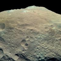
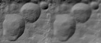
QUOTE (Sarunia @ Nov 15 2012, 01:49 PM) .... i love you image with exaggerated colors. Thanks! QUOTE (elakdawalla @ Nov 16 2012, 06:16 PM) I have not yet seen a *single* color global mosaic. As far as I know, the only way to get a higher-resolution color global view than the 100-ish-pixel ones from way early in the approach phase is to do it the hard way: build a shape model, create global color and albedo maps, reproject things back out to a simulated view. It's making me absolutely crazy. It's not the only way, nevertheless it's difficult. BTW, thanks for that huge gallery, it's very useful. Another glimpse from my planned blog entry - southern mountain in red-infrared view:
Attached thumbnail(s)
-------------------- |
|
|
|
|
|
|
Nov 16 2012, 06:32 PM
Post
#36
|
|
|
Administrator Group: Admin Posts: 5172 Joined: 4-August 05 From: Pasadena, CA, USA, Earth Member No.: 454 |
I would be very grateful if you could do that one in approximate true color. I want to update my "all asteroids visited by spacecraft" poster and do it in color this time. Fortunately I won't be hampered by there being no color global photos of Vesta because Vesta is so big that if I tried to put the whole thing on it, you wouldn't see most of the others. So I'm only planning to have it peek over the edge.
-------------------- My website - My Patreon - @elakdawalla on Twitter - Please support unmannedspaceflight.com by donating here.
|
|
|
|
|
Nov 16 2012, 06:57 PM
Post
#37
|
||
|
Member Group: Members Posts: 796 Joined: 27-February 08 From: Heart of Europe Member No.: 4057 |
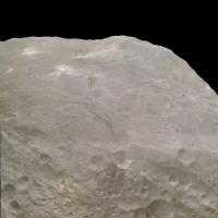
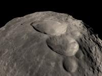
I haven't that one in "true" colors, but I have this one (which is similar) in filters 7, 2, 8 (centered at 653, 555 and 438 nm).
Based on spectra, Vesta is red object, so this is probably close enough to true colors.
Attached thumbnail(s)
-------------------- |
|
|
|
|
|
|
Nov 16 2012, 08:38 PM
Post
#38
|
|
|
Administrator Group: Admin Posts: 5172 Joined: 4-August 05 From: Pasadena, CA, USA, Earth Member No.: 454 |
Thank you! And here is another index page, to the Survey phase data. And I have now split the Approach and Survey pages into sub-pages to avoid bringing Firefox to its knees.
https://planetary.s3.amazonaws.com/data/daw...awn_survey.html -------------------- My website - My Patreon - @elakdawalla on Twitter - Please support unmannedspaceflight.com by donating here.
|
|
|
|
|
Nov 17 2012, 12:22 AM
Post
#39
|
|
 IMG to PNG GOD Group: Moderator Posts: 2251 Joined: 19-February 04 From: Near fire and ice Member No.: 38 |
QUOTE (elakdawalla @ Nov 16 2012, 05:16 PM) I have not yet seen a *single* color global mosaic. As far as I know, the only way to get a higher-resolution color global view than the 100-ish-pixel ones from way early in the approach phase is to do it the hard way: build a shape model, create global color and albedo maps, reproject things back out to a simulated view. It's making me absolutely crazy. Yes, that's the way to go I think. And that's exactly what I'll probably do unless a shape model gets released within a not too long time (not likely to happen I think). |
|
|
|
|
Nov 17 2012, 07:27 AM
Post
#40
|
|
 Member Group: Members Posts: 444 Joined: 1-July 05 From: New York City Member No.: 424 |
QUOTE (elakdawalla @ Nov 16 2012, 12:16 PM) I have not yet seen a *single* color global mosaic. As far as I know, the only way to get a higher-resolution color global view than the 100-ish-pixel ones from way early in the approach phase is to do it the hard way: build a shape model, create global color and albedo maps, reproject things back out to a simulated view. It's making me absolutely crazy. Your blog post today discussing this problem mentions that the Vesta imaging team is working on a detailed 3d model of this lumpy bumpy world that is not likely to be released publicly soon. Its also my understanding from past posts that Vesta's topography is being mapped for the possibly separate purpose of mapping, not just the surface, but the density and distribution of Vestas entire mass, and combining this information with delicate Radio and Doppler effect measurements, all with the goal of obtaining a subterranean 3D map of the dwarf planets interior and also an accurate 3D map of the gravity environment around the planet, for navigation and other purposes. Is this a unitary 3D mapping project? Or is their little overlap between the work needed to create a 3D model needed for the visual "planetary taxidermy" described in your current post, and the work needed for subterranean visualization and the mapping of the gravity field. |
|
|
|
|
Nov 17 2012, 11:54 AM
Post
#41
|
|
|
IMG to PNG GOD Group: Moderator Posts: 2251 Joined: 19-February 04 From: Near fire and ice Member No.: 38 |
And now I suddenly remember that already more than a year ago (!) Tayfun Öner was creating preliminary but remarkably good 3D/shape models of Vesta:
http://www.unmannedspaceflight.com/index.p...st&p=176794 http://www.unmannedspaceflight.com/index.p...st&p=177432 |
|
|
|
|
Nov 17 2012, 04:38 PM
Post
#42
|
|
|
Founder Group: Chairman Posts: 14432 Joined: 8-February 04 Member No.: 1 |
You might want to take a look at this regarding shape files..
http://naif.jpl.nasa.gov/pub/naif/DAWN/kernels/dsk/ |
|
|
|
|
Nov 17 2012, 05:11 PM
Post
#43
|
|
|
Junior Member Group: Members Posts: 22 Joined: 23-August 11 From: France Member No.: 6134 |
This shape is from Dr Robert Gaskell produced after the survey orbit.
As i remember, this shape use the old system coordinate before the first change (Claudia as prime meridian) by Dawn Team. I made (year ago) a conversion for cmod file (I choose cmod because i think it is very easy 3d file structures to read) here: http://patzawa.perso.sfr.fr/Download/Astro...que/Mesh/Vesta/ But even with shape i have a problem to build small mosaic Vesta rotates very fast and condition of illumination change as well. |
|
|
|
|
Nov 17 2012, 07:40 PM
Post
#44
|
|
|
Junior Member Group: Members Posts: 22 Joined: 23-August 11 From: France Member No.: 6134 |
My quick attempt of projection to the shape model.
View of Rheasilvia with FC21A0003510_11207035045F1F and FC21A0003511_11207035630F1F: http://www.youtube.com/watch?v=59CyNAuSD8c |
|
|
|
|
Nov 18 2012, 07:45 PM
Post
#45
|
||
|
Junior Member Group: Members Posts: 52 Joined: 16-November 06 Member No.: 1364 |
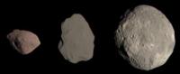
QUOTE (machi @ Nov 16 2012, 07:57 PM) I haven't that one in "true" colors, but I have this one (which is similar) in filters 7, 2, 8 (centered at 653, 555 and 438 nm). Based on spectra, Vesta is red object, so this is probably close enough to true colors. I think you're quite close. Here's what I get for the "true" colors of Steins, Lutetia, and Vesta.
|
|
|
|
|
|
|
Nov 19 2012, 03:55 PM
Post
#46
|
|
|
Member Group: Members Posts: 796 Joined: 27-February 08 From: Heart of Europe Member No.: 4057 |
Thank you for that image! That will be useful for my next project.
-------------------- |
|
|
|
|
Nov 19 2012, 10:19 PM
Post
#47
|
|
|
Senior Member Group: Members Posts: 2086 Joined: 13-February 10 From: Ontario Member No.: 5221 |
Just remember they're not to scale in Stefan's pic, machi.
|
|
|
|
|
Nov 19 2012, 10:52 PM
Post
#48
|
|
|
Member Group: Members Posts: 796 Joined: 27-February 08 From: Heart of Europe Member No.: 4057 |
I think that albedo is in scale.
-------------------- |
|
|
|
|
Nov 20 2012, 12:11 AM
Post
#49
|
|
|
Senior Member Group: Members Posts: 2086 Joined: 13-February 10 From: Ontario Member No.: 5221 |
The colors are fine, I know. I just mean the sizes in the picture are not correct; Emily made a montage that shows them right.
|
|
|
|
|
Nov 20 2012, 12:53 PM
Post
#50
|
|
|
Junior Member Group: Members Posts: 52 Joined: 16-November 06 Member No.: 1364 |
QUOTE (machi @ Nov 19 2012, 04:55 PM) Thank you for that image! That will be useful for my next project. You are very welcome! A few words on the image. I made it because I was curious how these asteroids would appear to the eye. I tried to display them at their correct relative brightness, as you guessed correctly. We all know that there are many ways to approach "true color". This is my version; now that the data are public, anyone is free to make her or his own. |
|
|
|
|
Nov 24 2012, 12:07 AM
Post
#51
|
|
|
Member Group: Members Posts: 796 Joined: 27-February 08 From: Heart of Europe Member No.: 4057 |
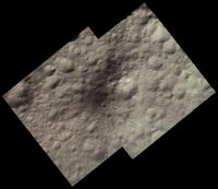
Mosaic of the south pole of Vesta and other images:

-------------------- |
|
|
|
|
Nov 24 2012, 12:46 AM
Post
#52
|
|
|
Senior Member Group: Members Posts: 2086 Joined: 13-February 10 From: Ontario Member No.: 5221 |
Stunning work machi! That's what we were all waiting for officially.
Thanks for the desktop! |
|
|
|
|
Nov 24 2012, 04:57 PM
Post
#53
|
|
 Lord Of The Uranian Rings Group: Members Posts: 798 Joined: 18-July 05 From: Plymouth, UK Member No.: 437 |
Merci Beaucoup!

-------------------- |
|
|
|
|
Nov 25 2012, 01:11 AM
Post
#54
|
|
|
Solar System Cartographer Group: Members Posts: 10166 Joined: 5-April 05 From: Canada Member No.: 227 |
Very nice mosaic - thanks!
Phil -------------------- ... because the Solar System ain't gonna map itself.
Also to be found posting similar content on https://mastodon.social/@PhilStooke Maps for download (free PD: https://upload.wikimedia.org/wikipedia/comm...Cartography.pdf NOTE: everything created by me which I post on UMSF is considered to be in the public domain (NOT CC, public domain) |
|
|
|
|
Nov 26 2012, 07:14 PM
Post
#55
|
|
|
Member Group: Members Posts: 796 Joined: 27-February 08 From: Heart of Europe Member No.: 4057 |
Thank you all!
I must say, that this dataset is really gorgeous, with many tempting shots for further work. For joy (we have almost winter), I did one big snowman. It's mosaic from 36 images (3×12) in false colors. I used filters F4 (917 nm), F6 (829 nm) and F7 (653 nm). 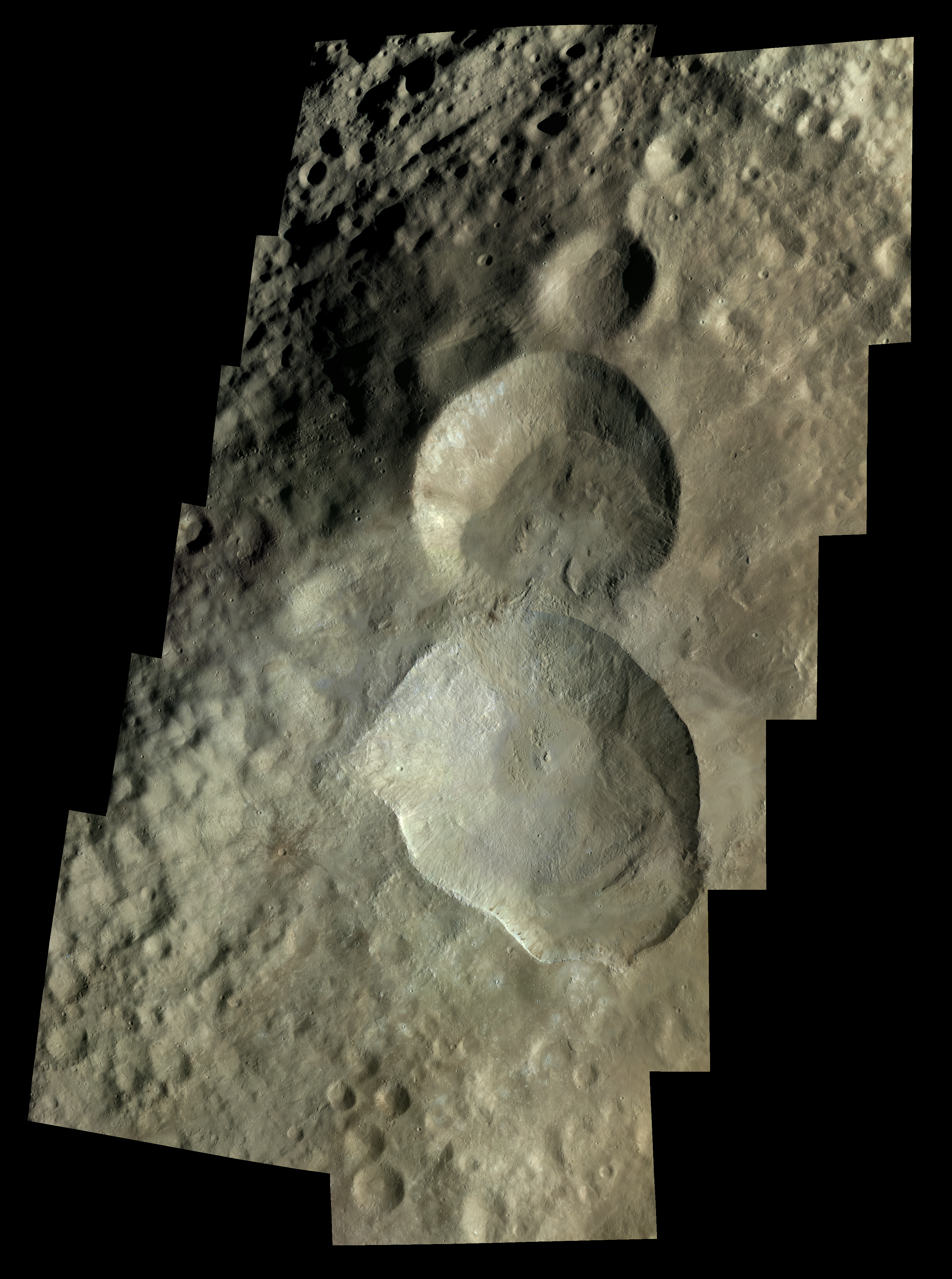
-------------------- |
|
|
|
|
Nov 26 2012, 07:25 PM
Post
#56
|
|
 Member Group: Members Posts: 655 Joined: 22-January 06 Member No.: 655 |
Wyborowy!!
|
|
|
|
|
Nov 26 2012, 08:22 PM
Post
#57
|
|
 Senior Member Group: Members Posts: 1431 Joined: 26-July 08 Member No.: 4270 |
That's amazing! Are those images from HAMO?
-------------------- -- Hungry4info (Sirius_Alpha)
|
|
|
|
|
Nov 26 2012, 08:33 PM
Post
#58
|
|
|
Member Group: Members Posts: 796 Joined: 27-February 08 From: Heart of Europe Member No.: 4057 |
Yes, that's images from HAMO. I forgot that. I used images from 8368 to 8408 and from 12329 to 12369 (respectively F4, F6, F7 filtered images in those sequences).
QUOTE (jasedm @ Nov 26 2012, 08:25 PM) Wyborowy!! You're welcome! BTW, I have no special knowledge of polish language, despite the fact, that I live few tens kilometers from Poland.
-------------------- |
|
|
|
|
Nov 26 2012, 08:33 PM
Post
#59
|
|
|
Junior Member Group: Members Posts: 22 Joined: 23-August 11 From: France Member No.: 6134 |
Machi, your mosaics of Rheasilva and Snowman craters are absolutely wonderful. Děkuji
|
|
|
|
|
Nov 26 2012, 08:50 PM
Post
#60
|
|
|
Member Group: Members Posts: 796 Joined: 27-February 08 From: Heart of Europe Member No.: 4057 |
Není zač!
-------------------- |
|
|
|
|
Nov 27 2012, 01:52 PM
Post
#61
|
|
|
IMG to PNG GOD Group: Moderator Posts: 2251 Joined: 19-February 04 From: Near fire and ice Member No.: 38 |
Wow! These are awesome mosaics, especially the 36 image mosaic.
QUOTE (Sarunia @ Nov 17 2012, 05:11 PM) This shape is from Dr Robert Gaskell produced after the survey orbit. As i remember, this shape use the old system coordinate before the first change (Claudia as prime meridian) by Dawn Team. I made (year ago) a conversion for cmod file (I choose cmod because i think it is very easy 3d file structures to read) here: http://patzawa.perso.sfr.fr/Download/Astro...que/Mesh/Vesta/ But even with shape i have a problem to build small mosaic Vesta rotates very fast and condition of illumination change as well. This seems to be a very high quality shape model that opens up some very interesting possibilities, even though there are major gaps near the north pole for obvious reasons (the shape model is from 2011). |
|
|
|
|
Nov 28 2012, 12:02 PM
Post
#62
|
||
|
Member Group: Members Posts: 102 Joined: 29-January 10 From: Poland Member No.: 5205 |
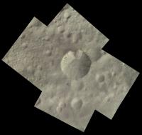
Here is my version of RGB Vesta
Images are taken 26 Jul 2011 R - FC21A0003496_11206015247F7K G - FC21A0003491_11206015148F2K B - FC21A0003497_11206015300F8K
-------------------- Adam Hurcewicz from Poland
|
|
|
|
|
|
|
Dec 7 2012, 01:27 AM
Post
#63
|
|
|
Senior Member Group: Members Posts: 1583 Joined: 14-October 05 From: Vermont Member No.: 530 |
Press release regarding "sinuous" gullies on Vesta:
http://www.nasa.gov/mission_pages/dawn/new...wn20121206.html The release images are nicely accessible here, too: http://dawn.jpl.nasa.gov/multimedia/vesta_dawn_gallery.asp All looks like it could just be dry sloughs to me, but neat nonetheless. |
|
|
|
|
Dec 16 2012, 12:13 AM
Post
#64
|
|
|
Newbie Group: Members Posts: 17 Joined: 24-August 12 Member No.: 6610 |
New image browsing tool availible at PDS for Vesta data.
is this a beta of Emilys tool ? http://dawn.psi.edu/data/PDS-Vesta/index.html -------------------- Thomas Gold was probably right about a iceball Mars.....
|
|
|
|
|
Jul 18 2013, 10:24 PM
Post
#65
|
|
|
IMG to PNG GOD Group: Moderator Posts: 2251 Joined: 19-February 04 From: Near fire and ice Member No.: 38 |
Two 8 month old posts from this thread:
QUOTE (djellison @ Nov 17 2012, 04:38 PM) You might want to take a look at this regarding shape files.. http://naif.jpl.nasa.gov/pub/naif/DAWN/kernels/dsk/ QUOTE (Sarunia @ Nov 17 2012, 05:11 PM) This shape is from Dr Robert Gaskell produced after the survey orbit. As i remember, this shape use the old system coordinate before the first change (Claudia as prime meridian) by Dawn Team. I made (year ago) a conversion for cmod file (I choose cmod because i think it is very easy 3d file structures to read) here: http://patzawa.perso.sfr.fr/Download/Astro...que/Mesh/Vesta/ But even with shape i have a problem to build small mosaic Vesta rotates very fast and condition of illumination change as well. I'm finally going to take a fairly detailed at the Vesta data and the first step is a shape model that the images will be draped over. I have the files mentioned above. Sarunia's cmod files are probably easier to handle but they are not the highest resolution available. The highest resolution files can be downloaded using the link posted by Doug but they are in a format that I need to convert to something else (possibly cmod). After exploring the data I'm getting the impression that converting them is going to require considerable work, possibly some programming (I have not found a converted version of the hi-res stuff anywhere). Yet the lower resolution versions have been converted to at least cmod. Does anyone know of any utilities that can read/convert this stuff? I haven't found any easy solution but I wouldn't be surprised if I have missed something. |
|
|
|
|
Jul 22 2013, 10:38 AM
Post
#66
|
|
|
Junior Member Group: Members Posts: 22 Joined: 23-August 11 From: France Member No.: 6134 |
QUOTE (Bjorn Jonsson @ Jul 19 2013, 12:24 AM) Two 8 month old posts from this thread: I'm finally going to take a fairly detailed at the Vesta data and the first step is a shape model that the images will be draped over. I have the files mentioned above. Sarunia's cmod files are probably easier to handle but they are not the highest resolution available. The highest resolution files can be downloaded using the link posted by Doug but they are in a format that I need to convert to something else (possibly cmod). After exploring the data I'm getting the impression that converting them is going to require considerable work, possibly some programming (I have not found a converted version of the hi-res stuff anywhere). Yet the lower resolution versions have been converted to at least cmod. Does anyone know of any utilities that can read/convert this stuff? I haven't found any easy solution but I wouldn't be surprised if I have missed something. VestaGaskellOldPM_512.cmod added: http://patzawa.perso.sfr.fr/Download/Astro...que/Mesh/Vesta/ No time to test it but i hope that it will be ok For the conversion, I use my own tool but it's very tricky and "unreleasable". When i have time i will try to do. |
|
|
|
|
Jul 24 2013, 11:50 PM
Post
#67
|
|
|
IMG to PNG GOD Group: Moderator Posts: 2251 Joined: 19-February 04 From: Near fire and ice Member No.: 38 |
QUOTE (Sarunia @ Jul 22 2013, 10:38 AM) VestaGaskellOldPM_512.cmod added: http://patzawa.perso.sfr.fr/Download/Astro...que/Mesh/Vesta/ No time to test it but i hope that it will be ok For the conversion, I use my own tool but it's very tricky and "unreleasable". When i have time i will try to do. Works perfectly - big thanks . I converted this from binary cmod to ASCII cmod using cmodfix (a utility associated with Celestia). It was very easy to then read the ASCII cmod file into my software and now the fun starts. I will be posting results here sometime in August probably.
|
|
|
|
|
Jul 25 2013, 02:23 AM
Post
#68
|
|
|
Member Group: Members Posts: 890 Joined: 18-November 08 Member No.: 4489 |
glad something is working with the new format
i take it you have looked through the alpha "alpha_dsk_c.tar.Z" version of "cspice-N0064" In the folder /src/dskcook_c/ is example code on accessing the new format |
|
|
|
|
Jul 25 2013, 10:23 PM
Post
#69
|
|
|
IMG to PNG GOD Group: Moderator Posts: 2251 Joined: 19-February 04 From: Near fire and ice Member No.: 38 |
Yes, I knew about this example code but I haven't started experimenting with it. Getting the shape model in cmod format from Sarunia speeds things up a lot.
|
|
|
|
|
Jul 27 2013, 09:09 AM
Post
#70
|
|
|
Senior Member Group: Members Posts: 1729 Joined: 3-August 06 From: 43° 35' 53" N 1° 26' 35" E Member No.: 1004 |
an extremely interesting paper comparing Dawn and HST observations at Vesta: Comparing Dawn, Hubble Space Telescope, and Ground-Based Interpretations of (4) Vesta
|
|
|
|
|
Aug 8 2013, 09:47 PM
Post
#71
|
|
|
IMG to PNG GOD Group: Moderator Posts: 2251 Joined: 19-February 04 From: Near fire and ice Member No.: 38 |
Does anyone reading this know how accurate the released camera pointing information should be for the Dawn images? I'm getting close to reprojecting the images onto the shape model but I'm getting significant differences between Dawn's images of Vesta and images I render of the shape model using the viewing geometry information.
The differences range from typically 20-30 pixels for the RC3 images from the approach phase to ~250 pixel for the HAMO images. 250 corresponds to an error of more than 1° if the spacecraft position is assumed to be correct - this is a very large difference. I'm aware of the various coordinate systems. The file VESTA_COORDINATES_120918.PDF in the DOCUMENT directory in the PDS data contains information on these. The released data is in the Claudia Double-Prime system. I assumed that the shape model is in the IAU-2000 system, both because of Sarunia's post earlier in this thread and because of the following line in the CMT files that come with the shape model: REF_FRAME_NAME = 'IAU_VESTA' But because of the mismatches I get I also tried rendering the shape model by assuming that it was in some of the other coordinate systems but that did not result in an improvement. It's rather difficult to debug this stuff because I really have nothing I know is 100% correct that I can use as ground truth. I think my code is working correctly and the shape model cannot be this inaccurate (for one thing, if it was it wouldn't have been released). So I'm leaning towards inaccurate pointing information. That's not exactly something new when dealing with spacecraft data but what makes me somewhat suspicious (and is the reason I'm posting this instead of simply 'correcting' the pointing) is the large mismatch I get in the HAMO images, as indicated above. Usually the spacecraft position is very accurate in the SPICE kernels and image labels; I assume that is the case here too. If this is likely to be due to inaccurate pointing I'll simply correct the pointing; otherwise it's back to debugging my code. |
|
|
|
|
Aug 8 2013, 10:00 PM
Post
#72
|
|
|
Administrator Group: Admin Posts: 5172 Joined: 4-August 05 From: Pasadena, CA, USA, Earth Member No.: 454 |
I've sent an email to a friend on the Dawn team pointing him to your post -- let's see if I get a response.
-------------------- My website - My Patreon - @elakdawalla on Twitter - Please support unmannedspaceflight.com by donating here.
|
|
|
|
|
Aug 8 2013, 11:58 PM
Post
#73
|
|
|
Junior Member Group: Members Posts: 22 Joined: 23-August 11 From: France Member No.: 6134 |
The shape from Gaskell seems to use the old prime meridian with a pole orientation corrected.
So I modified the vesta related SPICE pck file like this: BODY2000004_POLE_RA = ( 309.031 0.0 0.0 ) BODY2000004_POLE_DEC = ( 42.235 0.0 0.0 ) BODY2000004_PM = ( 292.0 1617.332776 0.0 ) Below the result of a projection with a survey picture (FC21A0005503_11232092641F1F):  (On Top left: only the shape shading. Top Right: projection+shape shading. Bottom Left: only the projection result) But frankly i didn't measure the actual precision (but certainly not a 30 pixels difference) and didn't try with an HAMO pictures. In waiting for the Dawn Team answer for more informations. |
|
|
|
|
Aug 9 2013, 12:32 AM
Post
#74
|
|
|
IMG to PNG GOD Group: Moderator Posts: 2251 Joined: 19-February 04 From: Near fire and ice Member No.: 38 |
QUOTE (Sarunia @ Aug 8 2013, 11:58 PM) The shape from Gaskell seems to use the old prime meridian with a pole orientation corrected. So I modified the vesta related SPICE pck file like this: BODY2000004_POLE_RA = ( 309.031 0.0 0.0 ) BODY2000004_POLE_DEC = ( 42.235 0.0 0.0 ) BODY2000004_PM = ( 292.0 1617.332776 0.0 ) It works!!! It never occurred to me that the shape model might be in a 'hybrid' coordinate system. 'Hacking' the pck file by applying this modification eliminated most of the discrepancies I was getting, at least for the RC3 images. I'll test the HAMO images tomorrow but I'm pretty sure they'll be fine. More tomorrow and possibly some preliminary image processing results. Big thanks.
|
|
|
|
|
Aug 10 2013, 11:03 PM
Post
#75
|
|||
|
IMG to PNG GOD Group: Moderator Posts: 2251 Joined: 19-February 04 From: Near fire and ice Member No.: 38 |
Everything works now. This is a test image where a HAMO image has been draped over the shape model:
Even though everything works I'm still interested in how accurate the relased camera pointing information should be. Some discrepancies remain but they are much smaller than earlier. For the RC3 images I've tested it's almost perfect though, the error is typically 2-4 pixels. In contrast, there are some differences between HAMO images and rendered shape model images, typically 20-30 pixels. That's probably normal. In the image above I made a relatively crude correction to the pointing - I'll do it more accurately once I start mosaicking images. I'm also interested in the accuracy of the spacecraft position; I'm assuming it to be very accurate. And now something different: Typically only image processing successes get posted here but I'm making a rare exception just to show what can happen when you're doing something new. This was supposed to be a simple cylindrical map of Vesta but there was a simple bug that caused it to have a very strange look:
|
||
|
|
|
||
|
Aug 11 2013, 08:19 AM
Post
#76
|
|
|
Member Group: Members Posts: 890 Joined: 18-November 08 Member No.: 4489 |
LSB vs. MSB
aren't 16 bit images fun |
|
|
|
|
Aug 12 2013, 10:27 AM
Post
#77
|
||
|
Junior Member Group: Members Posts: 22 Joined: 23-August 11 From: France Member No.: 6134 |
QUOTE (Bjorn Jonsson @ Aug 11 2013, 01:03 AM) Everything works now. This is a test image where a HAMO image has been draped over the shape model:
Even though everything works I'm still interested in how accurate the relased camera pointing information should be. Some discrepancies remain but they are much smaller than earlier. For the RC3 images I've tested it's almost perfect though, the error is typically 2-4 pixels. In contrast, there are some differences between HAMO images and rendered shape model images, typically 20-30 pixels. That's probably normal. In the image above I made a relatively crude correction to the pointing - I'll do it more accurately once I start mosaicking images. I'm also interested in the accuracy of the spacecraft position; I'm assuming it to be very accurate. Firstly I'm glad that your projections work now and I'm waiting for new pictures of Vesta I suppose that the Dawn Team quickly realized that the pole orientation measure with Hubble data is wrong. And i suppose that the decision of choosing Claudia as Prime merdien came latter when the Gaskell shape was already done. I think that i forgot something important: the rotation rate has been reevaluated too. I just get it when i read your comments. So in order to work with Gaskell shape i think that the parameters in pck file should be: BODY2000004_POLE_RA = ( 309.031 0.0 0.0 ) BODY2000004_POLE_DEC = ( 42.235 0.0 0.0 ) BODY2000004_PM = ( 292.0 1617.3329428 0.0 ) The difference concerned only rotation rate and is very small but maybe important i didn't test it. Concerning the accuracy of position and pointing, I'm not sure but i suppose that the pointing should be very precise since Dawn is able to orientate herself and every telemetry data are stored on board before sent to Earth. The position seems to me more problematic because the DNS sessions are limited. Someone has more info about it ? |
|
|
|
|
|
|
Aug 12 2013, 09:20 PM
Post
#78
|
|
|
Junior Member Group: Members Posts: 22 Joined: 23-August 11 From: France Member No.: 6134 |
I tested with the new rate rotation and it doesn't work: i have a difference of more than 5 pixels in a survey pictures.
I will try to investigate latter why. But i think that it is related to the Prime Meridian parameters should be adjusted if the rate rotation is adjusted. Very sorry for any confusion. |
|
|
|
|
Aug 13 2013, 09:34 PM
Post
#79
|
|
 Member Group: Members Posts: 568 Joined: 20-April 05 From: Silesia Member No.: 299 |
-------------------- Free software for planetary science (including Cassini Image Viewer).
http://members.tripod.com/petermasek/marinerall.html |
|
|
|
|
Aug 23 2013, 11:33 PM
Post
#80
|
||||
|
IMG to PNG GOD Group: Moderator Posts: 2251 Joined: 19-February 04 From: Near fire and ice Member No.: 38 |
I now have some results of my processing. They recently appeared in the the Planetary Society blog but for completeness I'm posting the images here as well. And there's more to come in (probably) a few days.
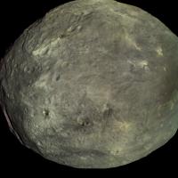
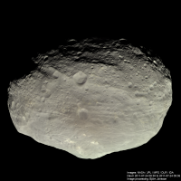
First an approximately true color global image (R/G/B filters used) from the RC3 approach data obtained at a distance of about 5200 km:
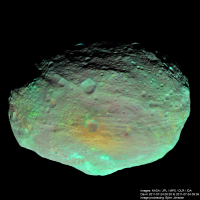
And a false color image from the same observation. Here images taken at 918 nm, 749 nm and 438 bm are used as red, green and blue, respectively:
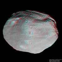
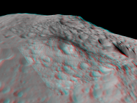
Each image is created from four sets of source images that have been draped over the shape model and the terminator then corrected as described in the blog entry I mentioned above. An here is an anaglyph made from the survey data using 18 blue filtered images. The processing is comparable to the processing used for the RC3 approach data above.
This is a wonderful dataset but it requires complicated processing if big, high quality mosaics are what you want. QUOTE (Sarunia @ Aug 12 2013, 09:20 PM) I tested with the new rate rotation and it doesn't work: i have a difference of more than 5 pixels in a survey pictures. I will try to investigate latter why. But i think that it is related to the Prime Meridian parameters should be adjusted if the rate rotation is adjusted. This is consistent with what I found. Previously the error (survey data) was ~8 pixels in the data I used, mainly in the horizontal direction. But when using the new rotation rate the error was bigger in the vertical direction (and also bigger in magnitude, about 10 pixels). And big thanks for your help (coordinate systems and converting the shape model) which greatly speeded up what I was doing - a great example of 'cooperative image processing'. I should mention that I'm still interested in the accuracy of the pointing data (SPICE CK kernels) if anyone knows anything about it, just to confirm that the source of the errors I'm getting is there (I think it is but I'm not 100% sure). |
|||
|
|
|
|||
|
Sep 18 2013, 11:19 PM
Post
#81
|
|||
|
IMG to PNG GOD Group: Moderator Posts: 2251 Joined: 19-February 04 From: Near fire and ice Member No.: 38 |
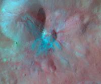
Here are two global mosaics from the survey phase of the mission:
Both of these images are mosaics of 17 individual color frames. The images were created by first creating a big simple cylindrical map and then draping it over the Gaskell shape model. The processing associated with this is similar to the processing of the images I posted earlier (see this Planetery Society blog entry for further details). This has been one of the most complex image processing projects I have ever finished. The left image is an approximately true color composite using data from the red, green and blue filters with the color corrected using Vesta's spectrum. This correction made the color a bit more saturated and reddish. Some color variations can be seen but they are rather subtle. The right image is from the same sequence but using data from the 918 nm, 749 nm and 438 nm (blue filter) as red, green and blue respectively. It has been processed to bring out color differences by first making Vesta's average global color approximately gray and then greatly increasing the color saturation. Note that this processing differs a bit from the processing of a similar image from the RC3 sequence. There I didn't make the average color gray before increasing the color saturation; this is the main reason for the different overall color here. This processing has brought out lots of interesting features. For example I find some of the long and narrow, red features interesting and now I also want to find higher resolution color data for some of the colorful craters in this composite (in other words: There's more to come). One caveat: There are probably some inaccuracies in the large scale color variations since it was difficult to get a competely seamless mosaic without manually messing a bit with the color where the images overlap to get rid of the seams. This was especially important here since the processing tends to bring out the seams and I don't want that. The source images were obtained on August 20, 2011 when Dawn was about 3000 km from Vesta's center. |
||
|
|
|
||
|
Sep 19 2013, 12:25 AM
Post
#82
|
|
|
Solar System Cartographer Group: Members Posts: 10166 Joined: 5-April 05 From: Canada Member No.: 227 |
Beautiful, Bjorn - well done!
Phil -------------------- ... because the Solar System ain't gonna map itself.
Also to be found posting similar content on https://mastodon.social/@PhilStooke Maps for download (free PD: https://upload.wikimedia.org/wikipedia/comm...Cartography.pdf NOTE: everything created by me which I post on UMSF is considered to be in the public domain (NOT CC, public domain) |
|
|
|
|
Sep 19 2013, 02:55 PM
Post
#83
|
|
|
Interplanetary Dumpster Diver Group: Admin Posts: 4404 Joined: 17-February 04 From: Powell, TN Member No.: 33 |
Simply stunning! These are the first large, color mosaics without gaps with consistent illumination that I have seen of Vesta.
-------------------- |
|
|
|
|
Oct 20 2013, 09:18 PM
Post
#84
|
|
|
Junior Member Group: Members Posts: 48 Joined: 10-September 06 Member No.: 1129 |
Does anyone know when we can expect the first better-than-Hubble images of Ceres?
|
|
|
|
|
Oct 20 2013, 09:28 PM
Post
#85
|
|
|
Administrator Group: Admin Posts: 5172 Joined: 4-August 05 From: Pasadena, CA, USA, Earth Member No.: 454 |
It will be not long after they get the first pictures, and that will be in February 2015.
-------------------- My website - My Patreon - @elakdawalla on Twitter - Please support unmannedspaceflight.com by donating here.
|
|
|
|
|
Jan 8 2014, 02:55 PM
Post
#86
|
|
|
Member Group: Members Posts: 102 Joined: 29-January 10 From: Poland Member No.: 5205 |
Here is Dawn approach to Vesta from 305 images at 2 FPS.
See at 720p to better view. http://www.youtube.com/watch?v=IAjsqqsuDqE -------------------- Adam Hurcewicz from Poland
|
|
|
|
|
Jun 22 2014, 01:34 AM
Post
#87
|
|||
|
IMG to PNG GOD Group: Moderator Posts: 2251 Joined: 19-February 04 From: Near fire and ice Member No.: 38 |
Strictly speaking not PDS but it's comparable: I recently found this goldmine of data from Dawn:
http://dawndata.igpp.ucla.edu/tw.jsp?section=data I'm not sure why I didn't find this earlier. A possible reason is that it's apparently relatively new (most of the files there have dates from November 2013). Among other things this site includes a very hi-res DEM/shapemodel of Vesta: http://dawndata.igpp.ucla.edu/tw.jsp?secti...Ms/DLR_HAMO_DTM This DEM has a much higher resolution than the DEM discussed earlier in this thread, i.e. here and in more detail here. The north polar region is also better in the new model. Here is a quick comparison render:
The new shape model is in the Claudia coordinate system and not in a 'hybrid' coordinate system like the older one. In fact everything at the site mentioned above is in the Claudia coordinate system. Interestingly I'm getting significantly better pointing and/or position accuracy using the new shape model. There are also several maps there, including a true color map processed to appear as if the sun was illuminating all of the surface from directly above. Here is a quick and dirty test render that combines the true color map with the shape model. It has a 40 degree field of view:
The true color map has some artifacts and blank spots that are visible here. There is also a vertical 'seam' at x=0 in the shape model, a surprisingly common problem in various DEMs and maps. But this is easy to fix in Photoshop. |
||
|
|
|
||
|
Jul 22 2014, 04:30 PM
Post
#88
|
|||||
|
IMG to PNG GOD Group: Moderator Posts: 2251 Joined: 19-February 04 From: Near fire and ice Member No.: 38 |
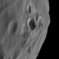
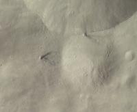
Here are two images showing Aricia Tholus:
North is up. The first one is an approximately true color mosaic from HAMO data. The second one shows more details and includes LAMO images colorized from the HAMO images. The HAMO images were obtained by Dawn on October 26, 2011 and the LAMO images on April 30, 2012. Dawn imaged Vesta globally using all of its color filters during the HAMO mission phase. A lot of clear filter coverage was also acquired during LAMO but color coverage is limited. Only the 918, 749 and 548 nm filters were used for color during LAMO, the images are 2x2 binned and only cover selected parts of Vesta's surface. So if you want RGB LAMO images you must use HAMO images to colorize the LAMO clear filter images. As in the images I have posted earlier in this thread, the above mosaics were made by using the shape model to reproject the images to simple cylindrical projection. All of the mosaicking and color work was then done in simple cylindrical projection and the final image products then made by rendering the shape model with the map draped over it. The shape model is big and accurate enough that this works very well for HAMO and LAMO data. I sometimes needed to translate the reprojected data by 1-2 pixels in the x and/or y direction though when doing color composites and/or mosaics. Aricia Tholus is really a mountain but this is not obvious in the images above where we are looking directly down. But an anaglyph made by draping the above HAMO image on the hi-res shape model shows this beautifully; here we are looking to the west:
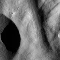
This also makes it obvious that even though some of Aricia Tholus is dark, parts of it are made darker by being tilted away from the sun. I should mention that I converted the shape model to a png file using the following img2png command: img2png global.pds -fstretch211946,293010 This results in a png file where black represents points that are 211.946 km from Vesta's center and white is 263.010 km from Vesta's center. This is the full elevation range of the shape model. The most recent version of img2png must be used for this to work properly. Of course it is also possible to use false color HAMO data to colorize the higher resolution LAMO data. Here is an example showing Aelia, a small crater with interesting streamer-like crater rays:
Here 918, 749 and 548 nm HAMO images are used for red, green and blue respectively. Color saturation has been greatly exaggerated, I set the saturation to 85 in Photoshop after first making the average color of the image gray. The HAMO images were obtained by Dawn on October 4, 2011 and the two LAMO images on January 10, 2012 and April 30, 2012. |
||||
|
|
|
||||
|
Jul 22 2014, 06:56 PM
Post
#89
|
|
|
Member Group: Members Posts: 796 Joined: 27-February 08 From: Heart of Europe Member No.: 4057 |
Beautiful images!
BTW, I missed completely your last post so thank you for that link with DEM, I didn't know it. I hope they will release DEM with topography relative to some gravitational equipotential surface. -------------------- |
|
|
|
|
Jul 22 2014, 07:51 PM
Post
#90
|
|
|
Solar System Cartographer Group: Members Posts: 10166 Joined: 5-April 05 From: Canada Member No.: 227 |
I missed that initial post too. Very interesting. I would really like to see a set of smaller browse images to let you get a quick feel for the data before downloading a bunch of > Gb files. But there's lots here to work with.
Phil -------------------- ... because the Solar System ain't gonna map itself.
Also to be found posting similar content on https://mastodon.social/@PhilStooke Maps for download (free PD: https://upload.wikimedia.org/wikipedia/comm...Cartography.pdf NOTE: everything created by me which I post on UMSF is considered to be in the public domain (NOT CC, public domain) |
|
|
|
|
Jul 26 2014, 06:57 PM
Post
#91
|
|
|
Member Group: Members Posts: 890 Joined: 18-November 08 Member No.: 4489 |
from another post of mine on a different forum
but the above data from http://dawndata.igpp.ucla.edu/tw.jsp?secti...Ms/DLR_HAMO_DTM 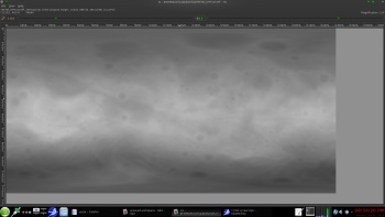 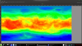 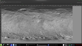 small lores mesh with a 4k normalmap and 4k texture 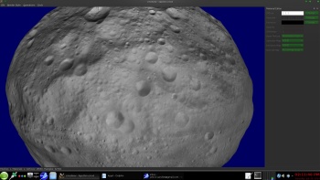  for some views of a 8ppd mesh from the 48 ppd DEM http://forum.celestialmatters.org/viewtopi...;p=12522#p12512 |
|
|
|
|
Jan 5 2015, 11:32 PM
Post
#92
|
||||
|
IMG to PNG GOD Group: Moderator Posts: 2251 Joined: 19-February 04 From: Near fire and ice Member No.: 38 |
Time flies. It's as if Dawn was at Vesta yesterday and yet there are only about two months until Ceres arrival. Here are two images showing Vesta's Numisa crater:
The left one is a true color RGB mosaic from HAMO images. The right one includes a single clear filter LAMO frame that has been colorized from the HAMO data. It shows a bigger amount of interesting small scale details, e.g. the small dark-rayed craters. And finally a false color mosaic from LAMO images obtained with the 918, 749 and 548 nm filters. The image has been processed to greatly exaggerate any color variations to better reveal compositional variations:
The big gaps are there because during the LAMO mission phase, Dawn didn't image Dawn globally in color. Also during LAMO, only images obtained with the clear filter are full resolution images. Images obtained with color/NIR filters are 2x2 binned so the resolution here isn't as high as in the RGB colorized clear filter image at top right. The HAMO images were obtained on 2011-10-27 and 2011-10-31. The single clear filter LAMO image was obtained on 2012-03-30. The LAMO images used to make the false color mosaic were obtained on 2012-02-07 and 2012-02-19 |
|||
|
|
|
|||
|
Jan 5 2015, 11:45 PM
Post
#93
|
|
|
Administrator Group: Admin Posts: 5172 Joined: 4-August 05 From: Pasadena, CA, USA, Earth Member No.: 454 |
Fantastic work, Bjorn.
FYI to all, the original plan (or at least the mission requirement) for Dawn at Vesta was for there to be *no* imaging during LAMO -- the fact we have anything, discontinuous though it might be, is terrific. Here are some relevant notes from an interview I did with Marc Rayman in preparation for a Sky & Tel article on Dawn at Ceres that's going to press soon. QUOTE Marc: Our original plan for Vesta LAMO was to not take pictures. Ultimately we did, and got an entire surface map, but our plan for Ceres is to take images. It's not a priority -- we don't have a requirement -- this is a way of illustrating that the most important objectives of LAMO are neither in imaging or visible and infrared spectrometry. It's gamma ray spectrometry, the neutron spectrometry, and gravity, and that's what drives us to LAMO.
-------------------- My website - My Patreon - @elakdawalla on Twitter - Please support unmannedspaceflight.com by donating here.
|
|
|
|
|
Jan 6 2015, 01:00 AM
Post
#94
|
|
|
Junior Member Group: Members Posts: 48 Joined: 10-September 06 Member No.: 1129 |
Forgive me if this was inferred in your post, but do you or anyone else know if we'll get true (or approximately true) color images of Ceres? I read somewhere that that was not planned.
|
|
|
|
|
Jan 6 2015, 05:48 AM
Post
#95
|
|
|
Administrator Group: Admin Posts: 5172 Joined: 4-August 05 From: Pasadena, CA, USA, Earth Member No.: 454 |
Yes, there will be color images, for sure. At least there will be color-filter images taken. But we didn't get much in the way of processed color images out of the Dawn mission officially; we had to wait for Bjorn and Daniel etc. to get a hold of the data in the PDS. I hope rather than expect things to be different at Ceres.
-------------------- My website - My Patreon - @elakdawalla on Twitter - Please support unmannedspaceflight.com by donating here.
|
|
|
|
|
Apr 20 2015, 01:56 AM
Post
#96
|
|
|
Member Group: Members Posts: 890 Joined: 18-November 08 Member No.: 4489 |
from the "HAMO_truecolor_DLR" folder
http://dawndata.igpp.ucla.edu/tw.jsp?secti...O_truecolor_DLR a reduced size 8 ppd copy of the 48 ppd mosaic 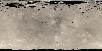 now if you want the REALLY HUGE map there are 3 -- 11.96 Gig maps here -- 20 Meters per pixel -- http://dawndata.igpp.ucla.edu/tw.jsp?secti.../LAMO_color_DLR |
|
|
|
|
Aug 28 2015, 07:22 AM
Post
#97
|
|
|
Member Group: Members Posts: 890 Joined: 18-November 08 Member No.: 4489 |
might be a down server ,but as of just now ( i noticed it ) the dawn links are dead
http://dawndata.igpp.ucla.edu replaced with a login screen |
|
|
|
|
Oct 20 2015, 03:15 PM
Post
#98
|
|
 Senior Member Group: Moderator Posts: 3233 Joined: 11-February 04 From: Tucson, AZ Member No.: 23 |
Ceres FC and VIR data from Approach and the RC3 orbit are now in the PDS:
http://sbn.psi.edu/pds/resource/dwncfc2.html http://sbn.psi.edu/pds/resource/dwncvir.html If you want to turn some of this data into maps, don't forget to download the latest PCK file for Ceres: http://naif.jpl.nasa.gov/pub/naif/DAWN/ker...n_ceres_v05.tpc -------------------- &@^^!% Jim! I'm a geologist, not a physicist!
The Gish Bar Times - A Blog all about Jupiter's Moon Io |
|
|
|
|
Oct 20 2015, 06:07 PM
Post
#99
|
|
 Member Group: Members Posts: 555 Joined: 27-September 10 Member No.: 5458 |
Over
Edit: Wow, they actually meant 19GB uncompressed, rather than Gb. -------------------- |
|
|
|
|
Oct 20 2015, 06:20 PM
Post
#100
|
||
|
Member Group: Members Posts: 555 Joined: 27-September 10 Member No.: 5458 |
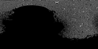
Someone care to explain why the bright spots in Occator are showing up so clearly here on a completely dark disc of Ceres?
Original File I'm at a complete loss... Edit: Probably a short exposure front lit image. Strange all the same. -------------------- |
|
|
|
|
|
 |

|
Lo-Fi Version | Time is now: 23rd May 2024 - 12:45 PM |
|
RULES AND GUIDELINES Please read the Forum Rules and Guidelines before posting. IMAGE COPYRIGHT |
OPINIONS AND MODERATION Opinions expressed on UnmannedSpaceflight.com are those of the individual posters and do not necessarily reflect the opinions of UnmannedSpaceflight.com or The Planetary Society. The all-volunteer UnmannedSpaceflight.com moderation team is wholly independent of The Planetary Society. The Planetary Society has no influence over decisions made by the UnmannedSpaceflight.com moderators. |
SUPPORT THE FORUM Unmannedspaceflight.com is funded by the Planetary Society. Please consider supporting our work and many other projects by donating to the Society or becoming a member. |
|