Traversing the Clay-Bearing Unit Along the Base of VRR, Site 73-79, sol 2297-2695, 22 Jan 2019-3 Mar 2020 |

Traversing the Clay-Bearing Unit Along the Base of VRR, Site 73-79, sol 2297-2695, 22 Jan 2019-3 Mar 2020 |
 Jan 22 2019, 12:11 PM Jan 22 2019, 12:11 PM
Post
#1
|
||
 Senior Member  Group: Members Posts: 2430 Joined: 30-January 13 From: Penang, Malaysia. Member No.: 6853 |
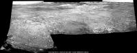
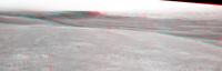
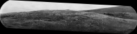
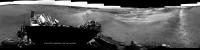
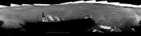
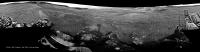
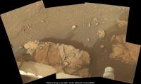
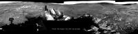
~50 minute drive on sol 2297, unsure of the direction, but this partial pan from the 6 available L-NavCam frames may help narrow down the location. Roughly assembled in MS ICE, no additional image processing.
edit, typo fixed |
|
 |
 
|
|
 |
|
Jan 23 2019, 11:52 AM
Post
#2
|
||
|
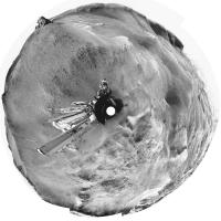
Senior Member Group: Members Posts: 2430 Joined: 30-January 13 From: Penang, Malaysia. Member No.: 6853 |
A long-distance RMI mosaic from sol 2298, roughly stitched together in MS ICE, no additional processing.
|
|
|
|
|
|
|
Jan 23 2019, 03:35 PM
Post
#3
|
|
 Senior Member Group: Members Posts: 4252 Joined: 17-January 05 Member No.: 152 |
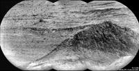
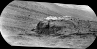
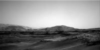
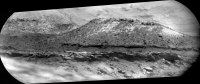
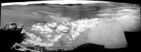
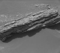
We're starting to get a stunning view of the south edge of VRR:
|
|
|
|
|
Jan 23 2019, 04:43 PM
Post
#4
|
|||
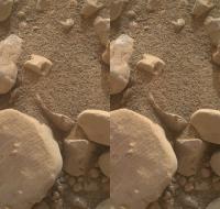
 Member Group: Members Posts: 238 Joined: 15-January 13 Member No.: 6842 |
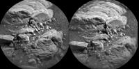
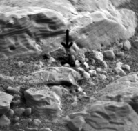
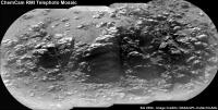
Sol 2297 ChemCam. Some little rocks got displaced by the laser? Or the result of drilling?
*flick GIF)
-------------------- Curiosity rover panoramas: http://www.facebook.com/CuriosityRoverPanoramas
My Photosynth panoramas: http://photosynth.net/userprofilepage.aspx...;content=Synths |
||
|
|
|
||
|
Jan 23 2019, 07:21 PM
Post
#5
|
|
|
Solar System Cartographer Group: Members Posts: 10191 Joined: 5-April 05 From: Canada Member No.: 227 |
Just the laser. As if you can say 'just the laser' about firing a laser on Mars.
Phil -------------------- ... because the Solar System ain't gonna map itself.
Also to be found posting similar content on https://mastodon.social/@PhilStooke Maps for download (free PD: https://upload.wikimedia.org/wikipedia/comm...Cartography.pdf NOTE: everything created by me which I post on UMSF is considered to be in the public domain (NOT CC, public domain) |
|
|
|
|
Jan 23 2019, 11:06 PM
Post
#6
|
|||
|
Member Group: Members Posts: 866 Joined: 15-March 05 From: Santa Cruz, CA Member No.: 196 |
Great works, keep them coming!
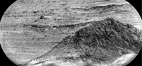
as fredk noted above, the south end of VRR is coming into view and it seems to be smoothing out a bit, made me think of the view into Endeavor just before going down into Perseverance.. fascinating looking at all the super-fine layering these sols.. here's an attempted stereo of sol2298 stitch anaglyph and crosseye
|
||
|
|
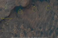
|
||
|
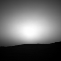
Jan 24 2019, 05:11 AM
Post
#7
|
|||
|
Member Group: Members Posts: 306 Joined: 4-October 14 Member No.: 7273 |
My takes on the recent RMI mosaics:
Sol 2295
Sol 2298
|
||
|
|
|
||
|
Jan 24 2019, 08:23 AM
Post
#8
|
|
|
Member Group: Members Posts: 282 Joined: 18-June 04 Member No.: 84 |
Reminiscent of parts of the interior of Endurance and Victoria Craters at Meridiani
|
|
|
|
|
Jan 24 2019, 03:52 PM
Post
#9
|
|||
|
Senior Member Group: Members Posts: 4252 Joined: 17-January 05 Member No.: 152 |
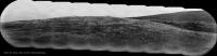
Long-baseline stereo views from sols 2298 and 2299. Anaglyph:
And cross-eyed:
|
||
|
|
|
||
|
Jan 25 2019, 03:57 PM
Post
#10
|
|
|
Member Group: Members Posts: 923 Joined: 10-November 15 Member No.: 7837 |
Sol 2299 Mastcam Right
DeBayered, repaired, extended sky...  Full width...  -------------------- |
|
|
|
|
Jan 25 2019, 07:47 PM
Post
#11
|
|
|
Member Group: Members Posts: 306 Joined: 4-October 14 Member No.: 7273 |
Hmm, I'd like to see some RMI mosaics of those erosional scarps. Looks like there's a couple good erosional exposures of the contacts there, might be helpful for doing some remote stratigraphy.
|
|
|
|
|
Jan 25 2019, 11:05 PM
Post
#12
|
|
|
Member Group: Members Posts: 923 Joined: 10-November 15 Member No.: 7837 |
Sol 2299 mastcam Right with CG Curiosity for context, scaled using HiRISE reference...
Zoom...  Wide...  -------------------- |
|
|
|
|
Jan 26 2019, 01:24 AM
Post
#13
|
|
|
Member Group: Members Posts: 923 Joined: 10-November 15 Member No.: 7837 |
-------------------- |
|
|
|
|
Jan 26 2019, 09:20 PM
Post
#14
|
|
|
Senior Member Group: Members Posts: 1074 Joined: 21-September 07 From: Québec, Canada Member No.: 3908 |
Sol 2299 Rmastcam panorama:
 Thanks Sean, again, for debayering these images. Sol 2299 Lmastcam post-drive view: 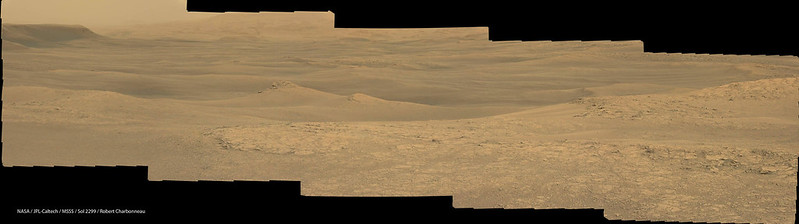 Sol 2300 Lmastcam post-drive: 
|
|
|
|
|
Jan 26 2019, 09:41 PM
Post
#15
|
||
|
Senior Member Group: Members Posts: 1074 Joined: 21-September 07 From: Québec, Canada Member No.: 3908 |
Sol 2301 RMI mosaic:
|
|
|
|
|
|
|
Jan 26 2019, 11:13 PM
Post
#16
|
||
|
Senior Member Group: Members Posts: 2430 Joined: 30-January 13 From: Penang, Malaysia. Member No.: 6853 |
Some lovely images, thanks all
2300 L-MastCam Weekend Workspace (MS ICE)
|
|
|
|
|
|
|
Jan 27 2019, 12:03 AM
Post
#17
|
||
|
Member Group: Members Posts: 306 Joined: 4-October 14 Member No.: 7273 |
My take on the VRR RMI mosaic:
|
|
|
|
|
|
|
Jan 28 2019, 02:42 AM
Post
#18
|
|||
|
Senior Member Group: Members Posts: 2430 Joined: 30-January 13 From: Penang, Malaysia. Member No.: 6853 |
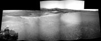
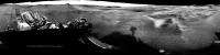
Soaking up the view after the drive on sol 2302

partial pan
|
||
|
|
|
||
|
Jan 28 2019, 08:56 PM
Post
#19
|
||
|
Senior Member Group: Members Posts: 2839 Joined: 22-April 05 From: Ridderkerk, Netherlands Member No.: 353 |
Back from Hospital and surgery and now stitching again.
The Navcam L view on Sol 2302. Jan van Driel
|
|
|
|
|
|
|
Jan 28 2019, 11:25 PM
Post
#20
|
|
|
Senior Member Group: Members Posts: 2430 Joined: 30-January 13 From: Penang, Malaysia. Member No.: 6853 |
QUOTE (jvandriel @ Jan 29 2019, 04:56 AM)  Back from Hospital and surgery and now stitching again. Good to have you back... |
|
|
|
|
Jan 29 2019, 02:04 PM
Post
#21
|
||
|
Senior Member Group: Members Posts: 2430 Joined: 30-January 13 From: Penang, Malaysia. Member No.: 6853 |
2302ML (drive direction?) Looking fairly wheel friendly, but maybe not too many contact science opportunities
|
|
|
|
|
|
|
Jan 30 2019, 07:17 PM
Post
#22
|
||
|
Solar System Cartographer Group: Members Posts: 10191 Joined: 5-April 05 From: Canada Member No.: 227 |
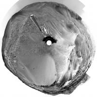
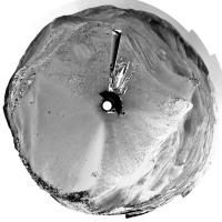
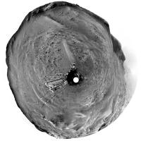
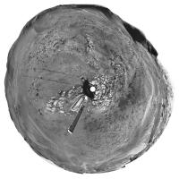
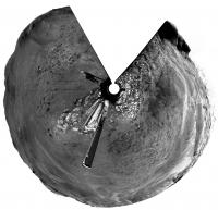
I'm glad you are back, Jan, and I hope you are doing well.
Here is your sol 2302 panorama in circular form. Paul - I think that drive direction mosaic was taken assuming the rover would be at the top of the ridge looking out across the wider landscape. Next time, maybe! Phil
-------------------- ... because the Solar System ain't gonna map itself.
Also to be found posting similar content on https://mastodon.social/@PhilStooke Maps for download (free PD: https://upload.wikimedia.org/wikipedia/comm...Cartography.pdf NOTE: everything created by me which I post on UMSF is considered to be in the public domain (NOT CC, public domain) |
|
|
|
|
|
|
Jan 30 2019, 07:39 PM
Post
#23
|
|||
 Administrator Group: Admin Posts: 5172 Joined: 4-August 05 From: Pasadena, CA, USA, Earth Member No.: 454 |
Ashwin confirmed to me today that they are "definitely on the clays," so I've created a new thread here.
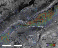
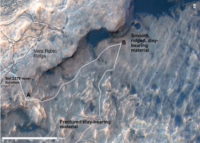
A newly posted LPSC abstract by Valerie Fox et al. details the plans for this phase of the mission. They plan to do a Z-shaped traverse -- first drive northeast along the base of the ridge to look at stratigraphy and reach the lowest-elevation point where there is a strong clay signal from orbit. Then they will turn southwest and climb across the clay-bearing unit vertically, until they get to the Greenheugh Pediment (the plateau made by the inverted channel coming off Mount Sharp). Then they'll turn southeast, poking along the base of the pediment and looking into alcoves. Here are a couple of maps from Fox et al.
Attached thumbnail(s)
-------------------- My website - My Patreon - @elakdawalla on Twitter - Please support unmannedspaceflight.com by donating here.
|
||
|
|
|
||
|
Jan 31 2019, 04:15 AM
Post
#24
|
||
|
Member Group: Members Posts: 306 Joined: 4-October 14 Member No.: 7273 |
Sol 2304 RMI mosaic of Greenheugh Pediment:
|
|
|
|
|
|
|
Jan 31 2019, 11:06 AM
Post
#25
|
||
|
Senior Member Group: Members Posts: 2839 Joined: 22-April 05 From: Ridderkerk, Netherlands Member No.: 353 |
The Navcam L view on Sol 2304.
Jan van Driel
|
|
|
|
|
|
|
Jan 31 2019, 12:16 PM
Post
#26
|
|
|
Senior Member Group: Members Posts: 1074 Joined: 21-September 07 From: Québec, Canada Member No.: 3908 |
Sol 2304 Lmastcam post-drive:
|
|
|
|
|
Jan 31 2019, 07:44 PM
Post
#27
|
|
|
Administrator Group: Admin Posts: 5172 Joined: 4-August 05 From: Pasadena, CA, USA, Earth Member No.: 454 |
According to Ashwin, sol 2302 was the day they drove in to the clay-bearing unit.
-------------------- My website - My Patreon - @elakdawalla on Twitter - Please support unmannedspaceflight.com by donating here.
|
|
|
|
|
Jan 31 2019, 10:55 PM
Post
#28
|
|
|
Member Group: Members Posts: 923 Joined: 10-November 15 Member No.: 7837 |
Sol 2302 panorama from mastcam left & right, debayered & blended with extended sky...
211 Megapixel  Curi context...  Detail...  Mastcam left deBayered frames for 2302 Mastcam right debayered frames for 2302 ( full batch ) Links are active for 7 days -------------------- |
|
|
|
|
Jan 31 2019, 11:03 PM
Post
#29
|
||
|
Senior Member Group: Members Posts: 2430 Joined: 30-January 13 From: Penang, Malaysia. Member No.: 6853 |
Those are lovely Sean
Partial NavCam pan after the short drive on sol 2306, roughly stitched in MS ICE
|
|
|
|
|
|
|
Feb 1 2019, 06:37 PM
Post
#30
|
||
|
Senior Member Group: Members Posts: 2839 Joined: 22-April 05 From: Ridderkerk, Netherlands Member No.: 353 |
The Navcam L view on Sol 2306.
Jan van Driel
|
|
|
|
|
|
|
Feb 2 2019, 12:45 AM
Post
#31
|
||||
|
Member Group: Members Posts: 866 Joined: 15-March 05 From: Santa Cruz, CA Member No.: 196 |
Nice stitches and renderings <charborob and sean>. (if youre like me and want to download them, and find that Flickr's "flic.kr" abbreviated URL scheme resolves to an overlay that doesn't have download menu widgets or even allow right-click download, you can simply append "/sizes" to the resultant URL to force to the 'all sizes' download page).
the scale of Curi in the distance serves to remind me how my eye tends to overestimate the scale of landscape features. Here are some quick stereo views from select sol2306 navcam sets
|
|||
|
|
|
|||
|
Feb 4 2019, 07:35 PM
Post
#32
|
|||
|
Solar System Cartographer Group: Members Posts: 10191 Joined: 5-April 05 From: Canada Member No.: 227 |
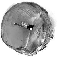
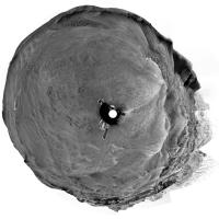
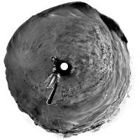
Here are Jan's last two panoramas in circular form, showing progress relative to the small ridge. We just drove down the other side of the ridge and turned left, so I can feel another map coming on.
Phil Sol 2304:
Sol 2306:
-------------------- ... because the Solar System ain't gonna map itself.
Also to be found posting similar content on https://mastodon.social/@PhilStooke Maps for download (free PD: https://upload.wikimedia.org/wikipedia/comm...Cartography.pdf NOTE: everything created by me which I post on UMSF is considered to be in the public domain (NOT CC, public domain) |
||
|
|
|
||
|
Feb 4 2019, 08:32 PM
Post
#33
|
||
|
Senior Member Group: Members Posts: 2839 Joined: 22-April 05 From: Ridderkerk, Netherlands Member No.: 353 |
The Navcam L view on Sol 2309.
Jan van Driel
|
|
|
|
|
|
|
Feb 6 2019, 09:13 PM
Post
#34
|
||
|
Solar System Cartographer Group: Members Posts: 10191 Joined: 5-April 05 From: Canada Member No.: 227 |
Jan's 2309 panorama in circular form. We are well beyond this now and I need to get onto the map.
Phil
-------------------- ... because the Solar System ain't gonna map itself.
Also to be found posting similar content on https://mastodon.social/@PhilStooke Maps for download (free PD: https://upload.wikimedia.org/wikipedia/comm...Cartography.pdf NOTE: everything created by me which I post on UMSF is considered to be in the public domain (NOT CC, public domain) |
|
|
|
|
|
|
Feb 6 2019, 09:27 PM
Post
#35
|
|||
|
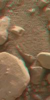
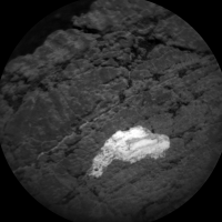
Member Group: Members Posts: 866 Joined: 15-March 05 From: Santa Cruz, CA Member No.: 196 |
MAHLIs of the rock with the LIBS sweep from sol2309 share an overlap that works for stereo (crosseye/anaglyph):
|
||
|
|
|
||
|
Feb 7 2019, 05:09 AM
Post
#36
|
||
|
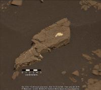
Senior Member Group: Members Posts: 2430 Joined: 30-January 13 From: Penang, Malaysia. Member No.: 6853 |
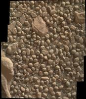
A rather nice looking outcrop, images from sol 2311 by the R-MastCam before the long drive, should look much nicer in colour when debayered, but even in its Bayer format it looked good enough to share here
|
|
|
|
|
|
|
Feb 7 2019, 11:40 AM
Post
#37
|
||
|
Senior Member Group: Members Posts: 1074 Joined: 21-September 07 From: Québec, Canada Member No.: 3908 |
Here is the debayered image:
And here is the sol 2311 Lmastcam post-drive panorama: 
|
|
|
|
|
|
|
Feb 8 2019, 02:46 PM
Post
#38
|
||
|
Senior Member Group: Members Posts: 2839 Joined: 22-April 05 From: Ridderkerk, Netherlands Member No.: 353 |
The Navcam L view on Sol 2311.
Jan van Driel
|
|
|
|
|
|
|
Feb 8 2019, 08:36 PM
Post
#39
|
||
|
Senior Member Group: Members Posts: 2839 Joined: 22-April 05 From: Ridderkerk, Netherlands Member No.: 353 |
and the view on Sol 2313.
Jan van Driel
|
|
|
|
|
|
|
Feb 10 2019, 01:04 AM
Post
#40
|
||
|
Senior Member Group: Members Posts: 2430 Joined: 30-January 13 From: Penang, Malaysia. Member No.: 6853 |
Sol 2313 L-MastCam post-drive panorama, easy driving conditions ahead
|
|
|
|
|
|
|
Feb 11 2019, 02:18 AM
Post
#41
|
||
|
Senior Member Group: Members Posts: 2430 Joined: 30-January 13 From: Penang, Malaysia. Member No.: 6853 |
Drive on sol 2316. Looks like an opportunity for some contact science, or maybe a another touch and go
Roughly assembled in MAS ICE using some of the post drive L-NavCams
|
|
|
|
|
|
|
Feb 11 2019, 03:20 AM
Post
#42
|
||
|
Solar System Cartographer Group: Members Posts: 10191 Joined: 5-April 05 From: Canada Member No.: 227 |
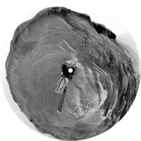
Thanks! Paul's partial panorama let me find the location for the map, and here is Jan's panorama from sol 2313 in circular form, showing tracks.
Phil
-------------------- ... because the Solar System ain't gonna map itself.
Also to be found posting similar content on https://mastodon.social/@PhilStooke Maps for download (free PD: https://upload.wikimedia.org/wikipedia/comm...Cartography.pdf NOTE: everything created by me which I post on UMSF is considered to be in the public domain (NOT CC, public domain) |
|
|
|
|
|
|
Feb 11 2019, 09:30 PM
Post
#43
|
||
|
Senior Member Group: Members Posts: 2839 Joined: 22-April 05 From: Ridderkerk, Netherlands Member No.: 353 |
The Navcam L view on Sol 2316.
Jan van Driel
|
|
|
|
|
|
|
Feb 14 2019, 06:33 AM
Post
#44
|
||
|
Solar System Cartographer Group: Members Posts: 10191 Joined: 5-April 05 From: Canada Member No.: 227 |
Very nice, Jan. Here is a circular projection of your panorama.
Phil
-------------------- ... because the Solar System ain't gonna map itself.
Also to be found posting similar content on https://mastodon.social/@PhilStooke Maps for download (free PD: https://upload.wikimedia.org/wikipedia/comm...Cartography.pdf NOTE: everything created by me which I post on UMSF is considered to be in the public domain (NOT CC, public domain) |
|
|
|
|
|
|
Feb 15 2019, 06:03 AM
Post
#45
|
||
|
Member Group: Members Posts: 306 Joined: 4-October 14 Member No.: 7273 |
Enhanced movie of a dust devil drifting by on Sol 2310. Covers about 2 minutes, with 12 seconds between each frame.
|
|
|
|
|
|
|
Feb 18 2019, 10:14 PM
Post
#46
|
|
|
Senior Member Group: Members Posts: 2430 Joined: 30-January 13 From: Penang, Malaysia. Member No.: 6853 |
I seem to recall an announcement that MRO would be assigned solely to InSight for the initial part of its mission, with other orbiters providing the DSN relay for Curiosity. The most recent image in the MSL JPL image server was acquired on sol 2320, 4 sols ago. Has anyone heard of any communication issues? Also are there any status pages for the Mars orbiters that would provide this sort of detail TIA
|
|
|
|
|
Feb 20 2019, 06:54 AM
Post
#47
|
||
|
Senior Member Group: Members Posts: 2430 Joined: 30-January 13 From: Penang, Malaysia. Member No.: 6853 |
Sol 2320: Left NavCam post drive partial pan, roughly assembled in MS-ICE. Poorly stitched, but hopefully it will assist in narrowing down the new location
|
|
|
|
|
|
|
Feb 20 2019, 08:27 PM
Post
#48
|
||
|
Senior Member Group: Members Posts: 2839 Joined: 22-April 05 From: Ridderkerk, Netherlands Member No.: 353 |
The Navcam L view on Sol 2320.
Jan van Driel
|
|
|
|
|
|
|
Feb 20 2019, 10:34 PM
Post
#49
|
||
|
Solar System Cartographer Group: Members Posts: 10191 Joined: 5-April 05 From: Canada Member No.: 227 |
Thanks, Jan. I made a circular version of this panorama to show where we are, after taking the liberty of patching the image to show the tracks behind us where they were partly hidden by the rear antenna.
Phil
-------------------- ... because the Solar System ain't gonna map itself.
Also to be found posting similar content on https://mastodon.social/@PhilStooke Maps for download (free PD: https://upload.wikimedia.org/wikipedia/comm...Cartography.pdf NOTE: everything created by me which I post on UMSF is considered to be in the public domain (NOT CC, public domain) |
|
|
|
|
|
|
Feb 22 2019, 11:40 PM
Post
#50
|
|
|
Senior Member Group: Members Posts: 2430 Joined: 30-January 13 From: Penang, Malaysia. Member No.: 6853 |
The lack of images after Curiosity's drive on sol 2320 is explained in this release by NASA/JPL which documents a computer reset.
Link |
|
|
|
|
Feb 28 2019, 11:20 AM
Post
#51
|
|||
|
Senior Member Group: Members Posts: 2430 Joined: 30-January 13 From: Penang, Malaysia. Member No.: 6853 |
Science activities resume in Gale crater, with ten images from sol 2333 returned by Curiosity, here is a rather nice target imaged with ChemCam's RMI
Edit: Added the mast cam context image, scaled using AlgorimancerPG, apologies for the de-bayer colour Catch the rest of the images here |
||
|
|
|
||
|
Mar 1 2019, 11:05 AM
Post
#52
|
||
|
Senior Member Group: Members Posts: 2430 Joined: 30-January 13 From: Penang, Malaysia. Member No.: 6853 |
L-MastCam sol 2320 Workspace, assembled in MS ICE (unprocessed)
|
|
|
|
|
|
|
Mar 2 2019, 10:23 AM
Post
#53
|
||
|
Senior Member Group: Members Posts: 2430 Joined: 30-January 13 From: Penang, Malaysia. Member No.: 6853 |
L-MastCam mosaic: Sol 2320 NNE - ENE and ~200 meters from a possible drill site. Stitched in MS ICE, no additional processing.
|
|
|
|
|
|
|
Mar 6 2019, 01:05 AM
Post
#54
|
||
|
Senior Member Group: Members Posts: 2430 Joined: 30-January 13 From: Penang, Malaysia. Member No.: 6853 |
2338 NLA after a drive of ~24.4m ESE (Midnight Planets) roughly assembled in MS ICE no additional processing, may help identify the location
|
|
|
|
|
|
|
Mar 6 2019, 02:23 PM
Post
#55
|
||
|
Senior Member Group: Members Posts: 2839 Joined: 22-April 05 From: Ridderkerk, Netherlands Member No.: 353 |
The Navcam L panoramic view on Sol 2338.
Jan van Driel
|
|
|
|
|
|
|
Mar 6 2019, 08:03 PM
Post
#56
|
||
|
Solar System Cartographer Group: Members Posts: 10191 Joined: 5-April 05 From: Canada Member No.: 227 |
Jan's nice new panorama in circular format.
Phil
-------------------- ... because the Solar System ain't gonna map itself.
Also to be found posting similar content on https://mastodon.social/@PhilStooke Maps for download (free PD: https://upload.wikimedia.org/wikipedia/comm...Cartography.pdf NOTE: everything created by me which I post on UMSF is considered to be in the public domain (NOT CC, public domain) |
|
|
|
|
|
|
Mar 11 2019, 09:16 AM
Post
#57
|
|
|
Senior Member Group: Members Posts: 2430 Joined: 30-January 13 From: Penang, Malaysia. Member No.: 6853 |
QUOTE (Phil Stooke @ Mar 7 2019, 04:03 AM) Jan's nice new panorama in circular format. Looking like Curi is MIA again, today is sol 2344 
|
|
|
|
|
Mar 11 2019, 08:07 PM
Post
#58
|
||
|
Senior Member Group: Members Posts: 2839 Joined: 22-April 05 From: Ridderkerk, Netherlands Member No.: 353 |
The Mastcam L view on Sol 2312.
126 images Debayered and stitched. Thanks Sean, Debayering took me now 2-3 hours instead of 2-3 days. Jan van Driel
|
|
|
|
|
|
|
Mar 12 2019, 10:45 PM
Post
#59
|
|
|
Founder Group: Chairman Posts: 14433 Joined: 8-February 04 Member No.: 1 |
Update : https://www.jpl.nasa.gov/news/news.php?feature=7339
QUOTE Updated March 12, 2019, 10:40 a.m. PDT (1:40 p.m EDT): Curiosity experienced a computer reset on its Side-A computer on Wednesday, March 6, 2019 (Sol 2,339), that triggered the rover's safe mode. This was the second computer reset in three weeks; both resets were related to the computer's memory.
The mission team decided to switch from the Side-A computer back to the rover's Side-B computer, which it operated on for most of the mission until November of 2018. Side-B recently experienced its own memory issue; the team has since further diagnosed the matter, reformatting the Side-B computer to isolate areas of "bad" memory. As of today, Curiosity is out of safe mode, and the team is configuring the rover for new science operations in the clay unit. Curiosity is expected to return to science operations as early as Wednesday. |
|
|
|
|
Mar 13 2019, 02:59 AM
Post
#60
|
|
 Member Group: Members Posts: 214 Joined: 30-December 05 Member No.: 628 |
This sounds at least superficially similar to the events that caused Opportunity to shut down her flash memory. Does Curiosity have the same option if these problems continue?
|
|
|
|
|
Mar 14 2019, 09:19 PM
Post
#61
|
||
|
Senior Member Group: Members Posts: 2839 Joined: 22-April 05 From: Ridderkerk, Netherlands Member No.: 353 |
The MAHLI view on Sol 2339.
Jan van Driel
|
|
|
|
|
|
|
Mar 15 2019, 05:44 AM
Post
#62
|
|
|
Senior Member Group: Members Posts: 2430 Joined: 30-January 13 From: Penang, Malaysia. Member No.: 6853 |
Midnight Planets is indicating a drive on sol 2347 to Site 75/0000. However the front HazCams appear to indicate the rover remained at the same location.
Edit: Just realised this sequence was likely commanded as they switched to the other computer, so not an aborted drive. |
|
|
|
|
Mar 15 2019, 06:25 AM
Post
#63
|
||
|
Senior Member Group: Members Posts: 2430 Joined: 30-January 13 From: Penang, Malaysia. Member No.: 6853 |
My version of 'Fife' using the focus merged versions that were downlinked later:
Stitched and rotated in MS ICE, otherwise unprocessed.
|
|
|
|
|
|
|
Mar 16 2019, 09:08 AM
Post
#64
|
||
|
Senior Member Group: Members Posts: 2430 Joined: 30-January 13 From: Penang, Malaysia. Member No.: 6853 |
Hard to be sure, but there appears (to my ageing eyes) that there could be some cross bedding in this bayer encoded R-MastCam from sol 2339
|
|
|
|
|
|
|
Mar 17 2019, 12:44 PM
Post
#65
|
||
|
Senior Member Group: Members Posts: 2430 Joined: 30-January 13 From: Penang, Malaysia. Member No.: 6853 |
Looks like the MAHLI imaged a DRT site on sol 2349, I think it may be the site brushed back on 2339 before the reset. The MAHLI shows was looks like surface scratches from using the DRT(center of the brushed area). If these are scratches, it could bode well for easier drilling / sampling in this area.
|
|
|
|
|
|
|
Mar 17 2019, 02:49 PM
Post
#66
|
|
|
Member Group: Members Posts: 306 Joined: 4-October 14 Member No.: 7273 |
Cross-bedding is a possibility there. I remember seeing some crossbeds of similar dip in the rocks coming off VRR so I would not be surprised if they are present in much of the clay unit.
|
|
|
|
|
Mar 17 2019, 03:26 PM
Post
#67
|
||
|
Senior Member Group: Members Posts: 2839 Joined: 22-April 05 From: Ridderkerk, Netherlands Member No.: 353 |
The Mastcam L view on Sol 2339.
Jan van Driel
|
|
|
|
|
|
|
Mar 17 2019, 03:28 PM
Post
#68
|
||
|
Senior Member Group: Members Posts: 2839 Joined: 22-April 05 From: Ridderkerk, Netherlands Member No.: 353 |
and the Mastcam R view on Sol 2339.
Jan van Driel
|
|
|
|
|
|
|
Mar 18 2019, 02:25 PM
Post
#69
|
||
|
Senior Member Group: Members Posts: 2839 Joined: 22-April 05 From: Ridderkerk, Netherlands Member No.: 353 |
Nice view on Sol 2347.
Jan van Driel
|
|
|
|
|
|
|
Mar 20 2019, 03:10 PM
Post
#70
|
||
|
Senior Member Group: Members Posts: 2839 Joined: 22-April 05 From: Ridderkerk, Netherlands Member No.: 353 |
The Navcam L view on Sol 2352.
Jan van Driel
|
|
|
|
|
|
|
Mar 20 2019, 03:50 PM
Post
#71
|
|
|
Member Group: Members Posts: 306 Joined: 4-October 14 Member No.: 7273 |
Looking at a couple of posters last night, looks like the Clay-Bearing Unit might be named as "Glen Torridon". Not sure if it's still considered a subunit of the Murray formation, or if it's being split out into a new formation.
|
|
|
|
|
Mar 21 2019, 12:43 PM
Post
#72
|
||
|
Senior Member Group: Members Posts: 2430 Joined: 30-January 13 From: Penang, Malaysia. Member No.: 6853 |
There seems to be a little activity in a planned DD search using the NavCam early on sol 2353, the brief activity can just be observed in the unprocessed frames, just to the left of center, maybe a gust wind raised some surface dust. The proper processing could reveal more detail
There are also several darker frames in the very large set of bayer encoded L-MastCam sequence on sol 2350, which was the sol they imaged the Deimos transit. Clearly they can not be the sky darkening because of the eclipse so maybe they captured a vortex or vortex's passing close to the rover? The entire sequence has yet to the downlinked, but there are over 100 already down. Sadly I can't create a GIF with so many images, but here are 10 frames assembled into a simple GIF from the beginning of the sequence, where you can observe one of the events. Note I set the blink rate at a quarter of a second
|
|
|
|
|
|
|
Mar 21 2019, 01:12 PM
Post
#73
|
||
|
Senior Member Group: Members Posts: 2430 Joined: 30-January 13 From: Penang, Malaysia. Member No.: 6853 |
Drive direction (unprocessed) L-MastCam, sol 2352: Taking us further North into the clay deposits of Glen Torridon
|
|
|
|
|
|
|
Mar 21 2019, 02:34 PM
Post
#74
|
|||
|
Solar System Cartographer Group: Members Posts: 10191 Joined: 5-April 05 From: Canada Member No.: 227 |
Here are two circular projections of Jan's latest panoramas. I will use them to update the map when I can get to it, maybe not for a few days.
Phil Sol 2347:
Sol 2352:
-------------------- ... because the Solar System ain't gonna map itself.
Also to be found posting similar content on https://mastodon.social/@PhilStooke Maps for download (free PD: https://upload.wikimedia.org/wikipedia/comm...Cartography.pdf NOTE: everything created by me which I post on UMSF is considered to be in the public domain (NOT CC, public domain) |
||
|
|
|
||
|
Mar 21 2019, 02:58 PM
Post
#75
|
|
|
Senior Member Group: Members Posts: 4252 Joined: 17-January 05 Member No.: 152 |
QUOTE (PaulH51 @ Mar 21 2019, 01:43 PM) There are also several darker frames in the very large set of bayer encoded L-MastCam sequence on sol 2350 The darker frames' filenames end in "...C00_DXXX", versus "...K00_DXXX" for the rest, so there must be something different about the exposure or stretching on those. |
|
|
|
|
Mar 21 2019, 11:41 PM
Post
#76
|
|
|
Senior Member Group: Members Posts: 2430 Joined: 30-January 13 From: Penang, Malaysia. Member No.: 6853 |
QUOTE (fredk @ Mar 21 2019, 10:58 PM) The darker frames' filenames end in "...C00_DXXX", versus "...K00_DXXX" for the rest, so there must be something different about the exposure or stretching on those. Many thanks for the feedback, I'd not spotted the file name changes. Disappointing, was hoping it was a DD
|
|
|
|
|
Mar 22 2019, 01:18 AM
Post
#77
|
||
|
Senior Member Group: Members Posts: 2430 Joined: 30-January 13 From: Penang, Malaysia. Member No.: 6853 |
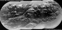
Long distance RMI of an outcrop located North(?) of the rover on sol 2354
|
|
|
|
|
|
|
Mar 22 2019, 02:20 PM
Post
#78
|
||
|
Senior Member Group: Members Posts: 2839 Joined: 22-April 05 From: Ridderkerk, Netherlands Member No.: 353 |
The Navcam L view on Sol 2350.
Jan van Driel
|
|
|
|
|
|
|
Mar 22 2019, 05:34 PM
Post
#79
|
|
|
Senior Member Group: Members Posts: 2517 Joined: 13-September 05 Member No.: 497 |
QUOTE (fredk @ Mar 21 2019, 06:58 AM) The darker frames' filenames end in "...C00_DXXX", versus "...K00_DXXX" for the rest, so there must be something different about the exposure or stretching on those. C means losslessly-compressed 8-bit raster image and K means losslessly-compressed 8-bit raster video, so by itself that doesn't say anything about the exposure (see https://pds-imaging.jpl.nasa.gov/data/msl/M...R_RDR_DPSIS.PDF ) but if you don't have the metadata you have no way to know what the exposure times were. -------------------- Disclaimer: This post is based on public information only. Any opinions are my own.
|
|
|
|
|
Mar 23 2019, 12:54 AM
Post
#80
|
||
|
Member Group: Members Posts: 866 Joined: 15-March 05 From: Santa Cruz, CA Member No.: 196 |
QUOTE (PaulH51 @ Mar 21 2019, 06:18 PM) Long distance RMI of an outcrop located North(?) of the rover on sol 2354 very nice, eons of wind sculpting have given its features a very appealing lens-like texture.
and yep its almost exactly North from here, part of the underexposed outcrop in the upper left of the navcam from sol2352 much better views in the bayered mastcam sol2353 or most recent color mastcam from sol2320 |
|
|
|
|
|
|
Mar 23 2019, 04:19 PM
Post
#81
|
||
|
Senior Member Group: Members Posts: 2839 Joined: 22-April 05 From: Ridderkerk, Netherlands Member No.: 353 |
The Navcam L view on Sol 2354.
Jan van Driel
|
|
|
|
|
|
|
Mar 24 2019, 03:30 PM
Post
#82
|
||
|
Senior Member Group: Members Posts: 2839 Joined: 22-April 05 From: Ridderkerk, Netherlands Member No.: 353 |
Playing with a few images on a Sunday afternoon.
Sol 2353 Mastcam L view. Jan van Driel
|
|
|
|
|
|
|
Mar 25 2019, 07:01 PM
Post
#83
|
||
|
Senior Member Group: Members Posts: 2839 Joined: 22-April 05 From: Ridderkerk, Netherlands Member No.: 353 |
and the complete Mastcam L view on Sol 2353.
Jan van Driel
|
|
|
|
|
|
|
Mar 25 2019, 08:56 PM
Post
#84
|
|
|
Member Group: Members Posts: 866 Joined: 15-March 05 From: Santa Cruz, CA Member No.: 196 |
|
|
|
|
|
Mar 26 2019, 03:12 AM
Post
#85
|
||
|
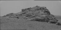
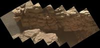
Senior Member Group: Members Posts: 2430 Joined: 30-January 13 From: Penang, Malaysia. Member No.: 6853 |
Looks like this is the L-MastCam drive direction section of what will be a wider mosaic from sol 2357 (MS-ICE / slightly darkened)
The mission update talked about speculation that the lone float rock (left of center) could be a meteorite or possibly or a remnant of a higher, eroded unit, but the next drive will take the rover to the subtle ridges (visible just to the left of the float rock) and image the float rock from there as well as the small butte in the middle of this mosaic.
|
|
|
|
|
|
|
Mar 26 2019, 03:47 AM
Post
#86
|
||
|
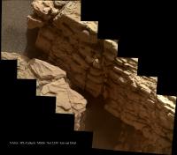
Senior Member Group: Members Posts: 2430 Joined: 30-January 13 From: Penang, Malaysia. Member No.: 6853 |
Long distance RMI mosaic of another exposure of the Vera Rubin Ridge, this time looking Northwest of the rover during sol 2357.
I used the 4 enhanced data product frames for this mosaic, a fifth image was not available in that format when I assembled this in MS-ICE, no additional processing except for adding the annotations.
|
|
|
|
|
|
|
Mar 26 2019, 10:06 AM
Post
#87
|
||
|
Senior Member Group: Members Posts: 2430 Joined: 30-January 13 From: Penang, Malaysia. Member No.: 6853 |
Posted this here to keep the signal to noise ratio down on the map thread. I've annotated my guesstimate of where the rover is after its drive on sol 2357 onto a crop of the JPL location map for sol 2354, but that's not the main reason for this post. For fun I'm looking at potential drill / sample sites in the clay unit...
I've circled three possible sites: A, B and C: My favourite at the moment is A, with C running a close second, C looks to have more potential, but it's a little off the published path.
|
|
|
|
|
|
|
Mar 26 2019, 01:58 PM
Post
#88
|
||
|
Senior Member Group: Members Posts: 2839 Joined: 22-April 05 From: Ridderkerk, Netherlands Member No.: 353 |
The Navcam L view on Sol 2357.
Jan van Driel
|
|
|
|
|
|
|
Mar 26 2019, 06:09 PM
Post
#89
|
||
|
Senior Member Group: Members Posts: 4252 Joined: 17-January 05 Member No.: 152 |
We had a transient darkening of the sky just after sunset on 2358. All I can think of is a Phobos transit, with centreline just to our north. Very cool. Here's an animation:
|
|
|
|
|
|
|
Mar 26 2019, 06:15 PM
Post
#90
|
|
|
Founder Group: Chairman Posts: 14433 Joined: 8-February 04 Member No.: 1 |
QUOTE (fredk @ Mar 26 2019, 10:09 AM) All I can think of is a Phobos transit Well spotted
|
|
|
|
|
Mar 26 2019, 07:46 PM
Post
#91
|
|
|
Solar System Cartographer Group: Members Posts: 10191 Joined: 5-April 05 From: Canada Member No.: 227 |
And not long ago we had that at InSight as well.
Phil -------------------- ... because the Solar System ain't gonna map itself.
Also to be found posting similar content on https://mastodon.social/@PhilStooke Maps for download (free PD: https://upload.wikimedia.org/wikipedia/comm...Cartography.pdf NOTE: everything created by me which I post on UMSF is considered to be in the public domain (NOT CC, public domain) |
|
|
|
|
Mar 26 2019, 09:51 PM
Post
#92
|
|
|
Senior Member Group: Members Posts: 1045 Joined: 17-February 09 Member No.: 4605 |
From Michelle Minitti's mission update 23 March "Finally, Navcam will attempt to capture Phobos, one of Mars's moons, transiting across the Sun in the Martian sky".
It seems their attempt was successful |
|
|
|
|
Mar 27 2019, 04:09 AM
Post
#93
|
||
|
Founder Group: Chairman Posts: 14433 Joined: 8-February 04 Member No.: 1 |
What my version of it using the raw JPGs looks like. And a whole thread of discussion about it right here : https://twitter.com/doug_ellison/status/1110748122831978496
Kudos to FredK for figuring it out before I'd even seen the images
|
|
|
|
|
|
|
Mar 27 2019, 04:05 PM
Post
#94
|
||
|
Senior Member Group: Members Posts: 4252 Joined: 17-January 05 Member No.: 152 |
Nice. Here's yet another version, subtracting the smoothed average of all the frames from each smoothed frame, and adding a multiple of that to each frame:
This is about 8x faster than real time. This site says this sequence spanned sunset, but I'm not sure how accurate that clock is. The optimal time to see this would be right after sunset - much later and the lower atmosphere wouldn't be illuminated directly by the sun so wouldn't directly experience the shadow. |
|
|
|
|
|
|
Mar 27 2019, 05:17 PM
Post
#95
|
|
|
Founder Group: Chairman Posts: 14433 Joined: 8-February 04 Member No.: 1 |
That site seems to be accurate to within about 15seconds of what I'm seeing on the ground.
First frame took longer to execute as the mast had to slew from stowed up to the pointing, and then iterate the auto-exposure a couple of times. Second frame was at 18:40:14, and the last at 18:43:13 - time between frames was around 7.5 seconds ( we didn't command a pause - that's just as quick as you can take images with the NavCams with some options turned off to speed things up) Sunset was 18:40:26, but 'local' sunset behind the back of the Vera Rubin Ridge was probably a little earlier than that. |
|
|
|
|
Mar 27 2019, 08:14 PM
Post
#96
|
||
|
Solar System Cartographer Group: Members Posts: 10191 Joined: 5-April 05 From: Canada Member No.: 227 |
Jan's panorama from sol 2357 in circular form. I can't emphasize enough how useful it is to have these panoramas posted like this to help me find locations for my maps. Thanks, Jan!
Phil
-------------------- ... because the Solar System ain't gonna map itself.
Also to be found posting similar content on https://mastodon.social/@PhilStooke Maps for download (free PD: https://upload.wikimedia.org/wikipedia/comm...Cartography.pdf NOTE: everything created by me which I post on UMSF is considered to be in the public domain (NOT CC, public domain) |
|
|
|
|
|
|
Mar 27 2019, 08:52 PM
Post
#97
|
||
|
Senior Member Group: Members Posts: 2839 Joined: 22-April 05 From: Ridderkerk, Netherlands Member No.: 353 |
Special for Phil,
the Navcam L view on Sol 2359. Jan van Driel
|
|
|
|
|
|
|
Mar 27 2019, 10:01 PM
Post
#98
|
|
|
Administrator Group: Admin Posts: 5172 Joined: 4-August 05 From: Pasadena, CA, USA, Earth Member No.: 454 |
QUOTE (jccwrt @ Mar 20 2019, 07:50 AM) Looking at a couple of posters last night, looks like the Clay-Bearing Unit might be named as "Glen Torridon". Not sure if it's still considered a subunit of the Murray formation, or if it's being split out into a new formation. I just asked Ashwin about this and got the following clarification: Glen Torridon refers to the geomorphological valley south of the Vera Rubin Ridge. It is more or less coincident with the CRISM clay signature, but not perfectly so. The clay unit doesn't have a name associated with it and won't until they've mapped its extent and figured out how it fits in with the Murray stratigraphy. -------------------- My website - My Patreon - @elakdawalla on Twitter - Please support unmannedspaceflight.com by donating here.
|
|
|
|
|
Mar 28 2019, 02:15 AM
Post
#99
|
|||
|
Member Group: Members Posts: 306 Joined: 4-October 14 Member No.: 7273 |
Thanks! Good to know.
NavCam caught a wind gust on Sol 2357, here is a processed video:
Also I tried my hand at processing and colorizing the eclipse sunset using a template sunset from Gusev Crater (thanks Spirit!) and some NavCam imagery taken the previous sol.
|
||
|
|
|
||
|
Mar 29 2019, 07:38 PM
Post
#100
|
||
|
Senior Member Group: Members Posts: 2839 Joined: 22-April 05 From: Ridderkerk, Netherlands Member No.: 353 |
The Navcam L view on Sol 2361.
Jan van Driel
|
|
|
|
|
|
 |

|
Lo-Fi Version | Time is now: 10th June 2024 - 03:32 PM |
|
RULES AND GUIDELINES Please read the Forum Rules and Guidelines before posting. IMAGE COPYRIGHT |
OPINIONS AND MODERATION Opinions expressed on UnmannedSpaceflight.com are those of the individual posters and do not necessarily reflect the opinions of UnmannedSpaceflight.com or The Planetary Society. The all-volunteer UnmannedSpaceflight.com moderation team is wholly independent of The Planetary Society. The Planetary Society has no influence over decisions made by the UnmannedSpaceflight.com moderators. |
SUPPORT THE FORUM Unmannedspaceflight.com is funded by the Planetary Society. Please consider supporting our work and many other projects by donating to the Society or becoming a member. |
|