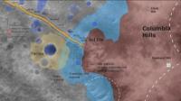
Spirit Route Map, Small and Large Scales |

Spirit Route Map, Small and Large Scales |
 Feb 17 2004, 01:07 AM Feb 17 2004, 01:07 AM
Post
#1
|
|
|
Founder  Group: Chairman Posts: 14434 Joined: 8-February 04 Member No.: 1 |
 
|
 |
 
|
 |
|
Feb 17 2004, 07:33 PM
Post
#2
|
|
|
Newbie Group: Members Posts: 2 Joined: 17-February 04 Member No.: 35 |
I'm a newbie here, but not enough of a "newbie" to appreciate the good work you do here. Great image. Looks like Spirit has it's work cut out for it. It would be cool if Spirit could get a good pic of it's heat shield inside that crater and perhaps some rock outcrops like Opportunity is looking at.

|
|
|
|
|
Feb 17 2004, 10:56 PM
Post
#3
|
|
|
Founder Group: Chairman Posts: 14434 Joined: 8-February 04 Member No.: 1 |
Added 21.6m for Sol 044
|
|
|
|
|
Feb 19 2004, 12:01 PM
Post
#4
|
|
|
Founder Group: Chairman Posts: 14434 Joined: 8-February 04 Member No.: 1 |
Updated to comply with a nasa release.
Doug |
|
|
|
|
Mar 6 2004, 12:11 PM
Post
#5
|
|
|
Rover Driver Group: Members Posts: 1015 Joined: 4-March 04 Member No.: 47 |
|
|
|
|
|
Mar 18 2004, 09:10 PM
Post
#6
|
|
|
Rover Driver Group: Members Posts: 1015 Joined: 4-March 04 Member No.: 47 |

|
|
|
|
| Guest_cassioli_* |
Apr 9 2004, 08:14 AM
Post
#7
|
|
Guests |
|
|
|
|
|
Apr 16 2004, 12:19 AM
Post
#8
|
|
|
Member Group: Members Posts: 109 Joined: 9-April 04 Member No.: 66 |
Is it possible to update these maps everyday?
|
|
|
|
| Guest_cassioli_* |
Apr 16 2004, 07:47 AM
Post
#9
|
|
Guests |
QUOTE (gregp1962 @ Apr 16 2004, 12:19 AM) Is it possible to update these maps everyday? I don't know, I just found the last one at NASA official Spirit site But I read somewhere in a forum that NASA does not post maps daily, only once per week or less.  Luca |
|
|
|
|
Apr 16 2004, 12:37 PM
Post
#10
|
|
|
Member Group: Admin Posts: 468 Joined: 11-February 04 From: USA Member No.: 21 |
Besides maybe an image or two a day with the updates, they appear to only be releasing synthesized images in batches at the press conferences, which are now once ever two weeks. So, write 'em a letter requesting a daily route map, hopefully they get enough feedback to implement one.
|
|
|
|
| Guest_Sunspot_* |
Apr 16 2004, 04:53 PM
Post
#11
|
|
Guests |
.....talking of updates, where have the new images from Spirit and Opportunity gone?
|
|
|
|
|
Apr 16 2004, 05:10 PM
Post
#12
|
|
 Junior Member Group: Members Posts: 95 Joined: 10-March 04 Member No.: 54 |
QUOTE (Sunspot @ Apr 16 2004, 04:53 PM) .....talking of updates, where have the new images from Spirit and Opportunity gone? They're here at last: http://qt.exploratorium.edu/mars/opportunity/ Tom |
|
|
|
| Guest_Sunspot_* |
Apr 16 2004, 05:20 PM
Post
#13
|
|
Guests |
QUOTE (Baltic @ Apr 16 2004, 05:10 PM) QUOTE (Sunspot @ Apr 16 2004, 04:53 PM) .....talking of updates, where have the new images from Spirit and Opportunity gone? They're here at last: http://qt.exploratorium.edu/mars/opportunity/ Tom They updated about 1 minute after i posted lol. Some of the Spirit images could from Sol 102, Spirit travelled 64 m on sol 100, and was due to drive again on sol 101. The images from pancam show a very different view, the rover could be approaching the second impact crater: http://qt.exploratorium.edu/mars/spirit/pa...00P2378R1M1.JPG |
|
|
|
|
Apr 28 2004, 09:24 AM
Post
#14
|
|
|
Founder Group: Chairman Posts: 14434 Joined: 8-February 04 Member No.: 1 |
New Route Map for Spirit - it's travelled further in the last 15 sols than it did in the first 90
http://marsrovers.jpl.nasa.gov/gallery/pre..._map_sol107.jpg |
|
|
|
| Guest_cassioli_* |
Apr 28 2004, 10:37 AM
Post
#15
|
|
Guests |
QUOTE (djellison @ Apr 28 2004, 09:24 AM) New Route Map for Spirit - it's travelled further in the last 15 sols than it did in the first 90 http://marsrovers.jpl.nasa.gov/gallery/pre..._map_sol107.jpg Why not to show it?  big BIGGER Luca |
|
|
|
| Guest_Sunspot_* |
Apr 28 2004, 10:42 AM
Post
#16
|
|
Guests |
QUOTE (djellison @ Apr 28 2004, 09:24 AM) New Route Map for Spirit - it's travelled further in the last 15 sols than it did in the first 90 http://marsrovers.jpl.nasa.gov/gallery/pre..._map_sol107.jpg I would guess Spirit has travlleed as much as 200m since that map was made, and may be perhaps halfway to "Lahontan Crater" by now. |
|
|
|
|
Apr 28 2004, 01:40 PM
Post
#17
|
|
|
Rover Driver Group: Members Posts: 1015 Joined: 4-March 04 Member No.: 47 |

|
|
|
|
| Guest_cassioli_* |
Apr 30 2004, 07:13 PM
Post
#18
|
|
Guests |
Opportunity sol 91
 Luca |
|
|
|
| Guest_cassioli_* |
May 22 2004, 12:17 PM
Post
#19
|
|
Guests |
|
|
|
|
| Guest_cassioli_* |
Jun 3 2004, 08:13 PM
Post
#20
|
|
Guests |
New map for Opportunity:
 Luca |
|
|
|
|
Jun 12 2004, 02:06 PM
Post
#21
|
||
|
Junior Member Group: Members Posts: 95 Joined: 10-March 04 Member No.: 54 |
Sorry, lousy picture quality. It's a snapshot from the flight director's update quicktime-movie.
Tom
Attached thumbnail(s)
|
|
|
|
|
|
|
Jun 15 2004, 06:08 PM
Post
#22
|
|
|
Junior Member Group: Members Posts: 95 Joined: 10-March 04 Member No.: 54 |

|
|
|
|
|
Jun 16 2004, 03:08 PM
Post
#23
|
|
|
Founder Group: Chairman Posts: 14434 Joined: 8-February 04 Member No.: 1 |
|
|
|
|
|
Sep 29 2004, 10:31 PM
Post
#24
|
|
 Member Group: Members Posts: 710 Joined: 28-September 04 Member No.: 99 |
Another fine map from sol 187:
http://marsrovers.jpl.nasa.gov/gallery/pre...map1-A190R1.jpg And another from sol 238: http://marsrovers.jpl.nasa.gov/gallery/pre...l238-A256R1.jpg |
|
|
|
|
Sep 30 2004, 02:31 PM
Post
#25
|
|
|
Rover Driver Group: Members Posts: 109 Joined: 2-May 04 From: Litchfield Park, Arizona (Phoenix area) Member No.: 71 |
I wish JPL would put out a zoomed in map of the hils with their intended route on it. Last images I saw seemed to indicate Spirit is on the move again but it's hard to know where they're headed.
|
|
|
|
|
Sep 30 2004, 02:39 PM
Post
#26
|
|
|
Founder Group: Chairman Posts: 14434 Joined: 8-February 04 Member No.: 1 |
They're basically heading up the ridge toward Husband Hill. They've not made a lot of progress though - infact, as I read it -
Doing science http://marsrovers.jpl.nasa.gov/gallery/all...1121L0M1-BR.JPG Backed up a bit http://marsrovers.jpl.nasa.gov/gallery/all...1212L0M1-BR.JPG Turned left a bit http://marsrovers.jpl.nasa.gov/gallery/all...41P1201L0M1.JPG Drove forward a bit http://marsrovers.jpl.nasa.gov/gallery/all...45P1212L0M1.JPG Then forward a bit more http://qt.exploratorium.edu/mars/spirit/fo...45P1212L0M1.JPG Doug |
|
|
|
|
Oct 8 2004, 12:32 AM
Post
#27
|
||
 The Insider Group: Members Posts: 669 Joined: 3-May 04 Member No.: 73 |
Here's the latest:
Attached thumbnail(s)
|
|
|
|
|
|
|
Nov 12 2004, 09:45 AM
Post
#28
|
|
|
Founder Group: Chairman Posts: 14434 Joined: 8-February 04 Member No.: 1 |
Where do you find these Pando?
Doug |
|
|
|
|
Nov 20 2004, 06:50 AM
Post
#29
|
|
|
The Insider Group: Members Posts: 669 Joined: 3-May 04 Member No.: 73 |
They are forwarded to me by a good friend. I can't really say much more than that

|
|
|
|
|
Nov 20 2004, 11:31 AM
Post
#30
|
|
|
Founder Group: Chairman Posts: 14434 Joined: 8-February 04 Member No.: 1 |
QUOTE (Pando @ Nov 20 2004, 06:50 AM) They are forwarded to me by a good friend. I can't really say much more than that Well - whoever they're from - please send my very very sincere thanks on behalf of the whole forum. It's very much appreciated. The press may have forgotten that they're still hard at work, but we havnt, and we watch in complete awe! Doug |
|
|
|
|
Nov 23 2004, 05:25 AM
Post
#31
|
|
 Senior Member Group: Members Posts: 1887 Joined: 20-November 04 From: Iowa Member No.: 110 |
A look at where spirit has been. View from sol 149

|
|
|
|
|
Nov 23 2004, 01:18 PM
Post
#32
|
|
|
Member Group: Members Posts: 242 Joined: 17-February 04 From: Ohio, USA Member No.: 34 |
Thanks alan,
This gives us a very different perspective. It looks like it's going to be a long climb. 
|
|
|
|
|
Nov 23 2004, 03:27 PM
Post
#33
|
|
|
Senior Member Group: Members Posts: 1887 Joined: 20-November 04 From: Iowa Member No.: 110 |
Spirit's path from Clovis

|
|
|
|
| Guest_Sunspot_* |
Nov 23 2004, 07:26 PM
Post
#34
|
|
Guests |
From space.com:
November 23 Mars Rover Spirit Takes a Brake Busily surveying the Columbia Hills at Gusev Crater, NASAs Spirit Mars Exploration Rover continues to suffer a bit of a brake down. Rover drivers at the Jet Propulsion Laboratory (JPL) in Pasadena, California continue to deal with Spirit wheel and brake issues. While surpassing its original warranty, Spirit has intermittently sent information in recent weeks that the brakes on two wheels were not releasing properly when the rover received commands to set a new course. Recent images relayed by Spirits navigation camera show in graphic detail what ground operators are dealing with. A westward view from the robot shows the effects of dragging its right front wheel, explained Leo Bister, Spirit mission manager. The image shown here was taken on November 19, during Spirits 313th day of martian operations as the rover drove backwards for about 98 feet (30 meters) on the day the picture was taken, Bister confirmed to SPACE.com . This type anomaly has not been observed on the Opportunity rover as it wheels around Endurance Crater on the other side of Mars. -- Leonard David |
|
|
|
|
Nov 23 2004, 08:15 PM
Post
#35
|
|
|
The Insider Group: Members Posts: 669 Joined: 3-May 04 Member No.: 73 |
I think they are completely wrong in that article. The dynamic braking problem is not the one causing for the wheel to drag through the soil.
The braking problem is related to the relay that locks the wheels during driving so the wheels won't turn or steer (not to be confused with rotating). They identified the issue as a faulty sensor on the relay, and are now ignoring it, so the problem is somewhat solved at this point. The wheel dragging is a completely different problem. It's the wheel motor that rotates the wheel, and it is causing excessive current draw. The motor or the gears are starting to wear out and so they are dragging the wheel on purpose to spare the motor (or gears) as much as they can. |
|
|
|
|
Nov 23 2004, 08:24 PM
Post
#36
|
|
|
Member Group: Members Posts: 710 Joined: 28-September 04 Member No.: 99 |
Correct me if I'm wrong, but isn't this all a bit of recycled 'news'? ( Except the 30 meters bit, didn't know that ). I hope the title should not be taken seriously... It has been three days since Spirit moved. Long weekend this time, or 'broken down'?
|
|
|
|
| Guest_Sunspot_* |
Nov 23 2004, 11:31 PM
Post
#37
|
|
Guests |
I think they're still moving:
21 Nov: http://qt.exploratorium.edu/mars/spirit/fo...00P1110R0M1.JPG 23 Nov: http://qt.exploratorium.edu/mars/spirit/fo...00P1214R0M1.JPG |
|
|
|
|
Nov 24 2004, 12:03 AM
Post
#38
|
|
|
Member Group: Members Posts: 710 Joined: 28-September 04 Member No.: 99 |
|
|
|
|
| Guest_Sunspot_* |
Nov 24 2004, 12:22 AM
Post
#39
|
|
Guests |
|
|
|
|
|
Nov 24 2004, 03:50 AM
Post
#40
|
|
|
Senior Member Group: Members Posts: 1887 Joined: 20-November 04 From: Iowa Member No.: 110 |
Vroom, vroom is right. New location, view from sol 149

|
|
|
|
|
Nov 24 2004, 07:24 AM
Post
#41
|
|
|
The Insider Group: Members Posts: 669 Joined: 3-May 04 Member No.: 73 |
How do you determine that Spirit is at the location marked 316? That seems pretty far away from the ridge and I don't think Spirit has got that far off its path.
I believe we are still close to the centerline on the ridge continuing straight towards Husband Hill... |
|
|
|
|
Nov 24 2004, 04:17 PM
Post
#42
|
|
|
Senior Member Group: Members Posts: 1887 Joined: 20-November 04 From: Iowa Member No.: 110 |
I found spirit's location in a nav cam image fron sol 310
 then matched rocks in the panarama from 149 
|
|
|
|
|
Nov 24 2004, 04:34 PM
Post
#43
|
|
|
Senior Member Group: Members Posts: 1887 Joined: 20-November 04 From: Iowa Member No.: 110 |
From a long time ago and a position far, far away

|
|
|
|
|
Nov 24 2004, 04:53 PM
Post
#44
|
|
|
Senior Member Group: Members Posts: 1887 Joined: 20-November 04 From: Iowa Member No.: 110 |
Thats odd, it worked in the preview.
Panorama from sol 149 again, fixed broken link. 
|
|
|
|
|
Nov 24 2004, 05:08 PM
Post
#45
|
|
|
Founder Group: Chairman Posts: 14434 Joined: 8-February 04 Member No.: 1 |
QUOTE (alan @ Nov 24 2004, 04:34 PM) From a long time ago and a position far, far away NOW it makes sense - if they traversed straight up the ridge - they solar arrays would be orientated WNW. By going to the left edge of that image - then up along near the skyline - they're orientated N / NNW - much better from an energy point of view. Excellent work Alan! |
|
|
|
|
Nov 24 2004, 05:46 PM
Post
#46
|
|
|
Senior Member Group: Members Posts: 1887 Joined: 20-November 04 From: Iowa Member No.: 110 |
I'm really pushing the resolution on this orbital view
 
|
|
|
|
|
Nov 24 2004, 05:47 PM
Post
#47
|
|
|
Rover Driver Group: Members Posts: 109 Joined: 2-May 04 From: Litchfield Park, Arizona (Phoenix area) Member No.: 71 |
Boy, I think you're off here. That light patch that shows up in the SOL 316 picture is very close up. Were it the same one in the distant color pan shot, it would be huge and those rocks you point out wouldn't even be seen they're so small. My guess is that you're right up through around 305 or 306 but then the rover starts climbing to the East. I doubt you can even see the area it's in right now from that distant pan. But who knows? I could be very wrong. It's why we desperately need an overhead route map drawn by the engineers driving the rover.
|
|
|
|
|
Nov 24 2004, 06:03 PM
Post
#48
|
|
|
The Insider Group: Members Posts: 669 Joined: 3-May 04 Member No.: 73 |
QUOTE I could be very wrong. It's why we desperately need an overhead route map drawn by the engineers driving the rover. azstrummer, this is as close as you can get. Trust me. I also think alan is a bit off there. The rover is still on the north side of the ridge which is connecting the West Spur with Husband Hill. 
|
|
|
|
|
Nov 24 2004, 06:07 PM
Post
#49
|
|
|
Rover Driver Group: Members Posts: 109 Joined: 2-May 04 From: Litchfield Park, Arizona (Phoenix area) Member No.: 71 |
That makes much more sense. In this pancam shot from Sol 315, the two "notches" on the hill ahead are clearly visible and if Spirit had gone north, the perspective would've been much different.

|
|
|
|
|
Nov 25 2004, 04:28 AM
Post
#50
|
|
|
Senior Member Group: Members Posts: 1887 Joined: 20-November 04 From: Iowa Member No.: 110 |
JPL included headings in the navcam panorama for sol 313 so I did some triangulation.
This is what I came up with 
|
|
|
|
|
Nov 30 2004, 04:39 AM
Post
#51
|
|
|
The Insider Group: Members Posts: 669 Joined: 3-May 04 Member No.: 73 |
Update: Spirit travel map until Sol 313

|
|
|
|
| Guest_Sunspot_* |
Nov 30 2004, 09:51 AM
Post
#52
|
|
Guests |
Hmmmm... no drive again today, perhaps those wheel problems have become a bit more serious.
|
|
|
|
|
Nov 30 2004, 01:45 PM
Post
#53
|
|
|
Member Group: Members Posts: 710 Joined: 28-September 04 Member No.: 99 |
QUOTE (Sunspot @ Nov 30 2004, 09:51 AM) Hmmmm... no drive again today, perhaps those wheel problems have become a bit more serious. Maybe..., but I think Spirit was still in the '5 day Thanksgiving weekend'. We'll see. |
|
|
|
| Guest_Sunspot_* |
Dec 1 2004, 10:02 AM
Post
#54
|
|
Guests |
Anyone have any inside info on what Spirit is upto?
|
|
|
|
|
Dec 1 2004, 10:47 PM
Post
#55
|
|
|
Senior Member Group: Members Posts: 1887 Joined: 20-November 04 From: Iowa Member No.: 110 |
A week off for Spirit, should have the battery fully charged. How about a 100 meter drive.?
|
|
|
|
| Guest_Sunspot_* |
Dec 1 2004, 10:57 PM
Post
#56
|
|
Guests |
There's very little new data coming down too. Just the usual images of the pancam calibration target and the Sun.
|
|
|
|
|
Dec 1 2004, 11:03 PM
Post
#57
|
|
 Interplanetary Dumpster Diver Group: Admin Posts: 4404 Joined: 17-February 04 From: Powell, TN Member No.: 33 |
I am still hoping for a pan from in between the hills, even if it is a Navcam pan, although I would prefer a Pancam pan. It is too bad that while the rover is parked they don't take advantage of such opportunities for a good color pan. This could be achieved through tri-color imaging and perhaps 2x2 or even 4x4 binning in 2 of the colors, or perhaps all three with a full resolution clear-filter data set. I realize this would be of little scientific use, but it would be great for future coffee table books.
-------------------- |
|
|
|
|
Dec 1 2004, 11:23 PM
Post
#58
|
|
|
Senior Member Group: Members Posts: 1887 Joined: 20-November 04 From: Iowa Member No.: 110 |
For the last 5 days MER site has posted 58 shots of the sundial and 18 of the sun. Are there images of something interesting to go with these waiting to transmitted?
|
|
|
|
|
Dec 2 2004, 06:23 AM
Post
#59
|
|
|
Senior Member Group: Members Posts: 1887 Joined: 20-November 04 From: Iowa Member No.: 110 |
Spirit is on the move. new position
 and the long view 
|
|
|
|
| Guest_Sunspot_* |
Dec 2 2004, 12:08 PM
Post
#60
|
|
Guests |
yayyyy..... on the move again, looks like another long drive too.
From this image http://qt.exploratorium.edu/mars/spirit/re...00P1313R0M1.JPG I get the impression that they may be starting to climb slightly. |
|
|
|
|
Dec 2 2004, 03:27 PM
Post
#61
|
|
|
Senior Member Group: Members Posts: 1887 Joined: 20-November 04 From: Iowa Member No.: 110 |
Look at the way the ground is torn up on the right and all the short turns on the left. I bet Spirit got a rock stuck in front of one of its wheels and was pushing it along. The extra tracks on the left must be the first few attempts to manuever around it.
http://qt.exploratorium.edu/mars/spirit/re...00P1313R0M1.JPG |
|
|
|
|
Dec 2 2004, 04:00 PM
Post
#62
|
|
|
Rover Driver Group: Members Posts: 109 Joined: 2-May 04 From: Litchfield Park, Arizona (Phoenix area) Member No.: 71 |
Alan, per your twin pictures you posted today - You seem right on with the black and white shot but it's my opinion you're way off the mark with the positioning in the color shot. I'm absolutely certain that Spirit is not taking this long trek to the North as you propose but is in the hollow out of sight to the east of where you show the position on Sol 310. The progression you're showing is taking them completely away from Husband Hill, their stated target. Look back again at the overhead shots. There's this large open expanse between the knob they originally drove to the top of and Husband Hill to the east. Most here seem to believe that's direction they're heading, not off to North as you keep posting. That color shot was taken from a long ways off while Spirit was approaching from the west and the features you seem to be using to pinpoint locations by comparing them with small rocks and dips in recent photos wouldn't even have been visible then.
Then again I could be just as off in my assessment. I Welcome the brainstorming none the less. |
|
|
|
|
Dec 3 2004, 01:58 AM
Post
#63
|
|
|
The Insider Group: Members Posts: 669 Joined: 3-May 04 Member No.: 73 |
Update:
Spirit completed acquiring a large "Thanksgiving" Pancam panorama on Sol 324 and is continuing the travel towards Husband Hill. Spirit has just about crossed the flat saddle area between Husband Hill and West Spur and will be blimbing steeper slopes soon. Sol 325 - Spirit continued driving Eastward across the flat saddle area between the West Spur of the Columbia Hills to where the terrain slopes back upwards towards Husband Hill. She successfully completed ~35 meters of 5-wheel driving bringing the total mission travel distance to 3.82 km Future Plans Next week Spirit will continue to drive further up the hills, and will be looking for outcrops along the way. Two possible routes are still being considered - a route that would head directly towards the top of husband hill, and a route that allows exploring of a steep walled canyon on the North side of Husband hill. |
|
|
|
|
Dec 3 2004, 02:17 AM
Post
#64
|
|
|
Interplanetary Dumpster Diver Group: Admin Posts: 4404 Joined: 17-February 04 From: Powell, TN Member No.: 33 |
Great! This might be the "pan between the hills" I wanted.
-------------------- |
|
|
|
|
Dec 3 2004, 02:18 AM
Post
#65
|
|
|
Senior Member Group: Members Posts: 1887 Joined: 20-November 04 From: Iowa Member No.: 110 |
Azstrummer, where do you think that pass in the distance is? Do you think it is the spot on my color image where I have been locating Spirit? The pass in the distance certainly looks like the pass between Clark Hill and Husband Hill to me. Take a look at it in this color panorama
http://www.whatonmars.com/womiod/11-2004/wom_iod041129a_.jpg and compare it to the one here http://marsrovers.jpl.nasa.gov/gallery/pre...-A143R1_br2.jpg |
|
|
|
|
Dec 3 2004, 02:59 AM
Post
#66
|
|
|
Rover Driver Group: Members Posts: 109 Joined: 2-May 04 From: Litchfield Park, Arizona (Phoenix area) Member No.: 71 |
Alan, I understand there are major similarities but you have to remember, that second image you keep showing was taken from at least a half mile away and you're comparing features from a picture where you're right next to rocks and hollows. Also that second picture was taken almost due west of the West Spur which would mean that the hollow between the spur and Husband Hill that Spirit is currently in would not be able to be seen from that perspective. Go back and look at the shots from the orbiters. The hollow between the spur and Husband is clearly visible. There simply are no other reference pictures to this area from the ground prior to Spirit's recent travels.
That pass in the distance that you refer to in the recent shots is merely an opening between some sub-hills blocking the main ones. Remember that Spirit went down into a hollow and the foreground features would surely block out the ones in the rear. My guess is that this is all going to become apparent in the next few days as Spirit climbs over these small ridges and the mass of Husband Hill looms ahead. You don't do much hiking I take it. lol |
|
|
|
|
Dec 3 2004, 03:47 AM
Post
#67
|
|
|
Senior Member Group: Members Posts: 1887 Joined: 20-November 04 From: Iowa Member No.: 110 |
No, boy scouts was a long time ago. We obviously have a different interpretation of what point on the overhead shots corrsponds to the end of the ridge Spirit was on and in what Spirit was direction was looking when it took the shot on 149. I got 110 degrees from the route map that was posted earlier. In the panorama from 313 I can see over the end of slope in that direction, so I'm assuming that its current position should be visible from there. It should become clear where Spirit is pretty soon. I expect it to turn to the right and head up the north edge of that ridge to the right of its current position. Of course that is pure speculton on my part.
|
|
|
|
|
Dec 3 2004, 04:57 AM
Post
#68
|
|
|
Rover Driver Group: Members Posts: 109 Joined: 2-May 04 From: Litchfield Park, Arizona (Phoenix area) Member No.: 71 |
I've been doing a great deal of looking at the pictures in 3D - been building my own anaglyphs. It's truly amazing when you do that how a seemingly flat terrain becomes this series of very extreme up and down ridges that the rover is climbing over. Just a few weeks ago they went from a view of very rough terrain with Husband Hill looming huge in the background down into this valley between the spur and the base of the hill and suddenly you couldn't see that huge foreboding hill anymore in any of the pans. I think that's where we kinda lost all reference with the rover down low enough that even the small foothills in the foreground were blocking out the massive rises behind them. If my theory's right then the next day's climb should get them back the big picture again. Who knows though. I've been wrong many times in this mission trying to decipher the trickle of stuff coming from JPL at times.
|
|
|
|
|
Dec 3 2004, 07:40 AM
Post
#69
|
|
|
Senior Member Group: Members Posts: 1887 Joined: 20-November 04 From: Iowa Member No.: 110 |
So much for my predicted right turn.

|
|
|
|
| Guest_Analyst_* |
Dec 7 2004, 03:05 PM
Post
#70
|
|
Guests |
Another drive for Spirit, now at site 98. Any idea - map - where we are? I'm lost between West Spur and Husband Hill
|
|
|
|
|
Dec 7 2004, 03:16 PM
Post
#71
|
|
|
Founder Group: Chairman Posts: 14434 Joined: 8-February 04 Member No.: 1 |
I'd say between the Sol 326 location - and the large rocks by the '3' of 326 on this
http://s02.imagehost.org/view.php?image=/0...rit_311-326.jpg Doug |
|
|
|
|
Dec 8 2004, 12:07 AM
Post
#72
|
|
|
Senior Member Group: Members Posts: 1887 Joined: 20-November 04 From: Iowa Member No.: 110 |
Here is a better image of spirit's location, pancam instead of navcam.
 Its not zig-zagging as much as it looks like in this image. |
|
|
|
|
Dec 8 2004, 12:39 AM
Post
#73
|
|
|
Senior Member Group: Members Posts: 1887 Joined: 20-November 04 From: Iowa Member No.: 110 |
New route map up on MER home page. It goes to sol 324, same place it was on 317.
http://marsrovers.jpl.nasa.gov/gallery/pre...vDEM-A332R1.jpg |
|
|
|
|
Dec 8 2004, 12:44 PM
Post
#74
|
|
|
Founder Group: Chairman Posts: 14434 Joined: 8-February 04 Member No.: 1 |
The drive from site 98 to site 99 was not very far at all.
One rock I spotted in both end-of-drive L7.R1 mosaics came out of the parallax calulator like this.. Site 98 object distance: 15.2 m, one-pixel error: 0.108 m object dimension: 43.0 cm Site 99 object distance: 4.296 m, one-pixel error: 0.009 m object dimension: 42.5 cm I used the large rock in this view for Site 99 http://qt.exploratorium.edu/mars/spirit/pa...00P2439L7M1.JPG Site 98 http://qt.exploratorium.edu/mars/spirit/pa...00P2438L7M1.JPG (it's right of centre) Thus - drive distance - to quite a high degree of accuracy - 11m  Doug and thi |
|
|
|
|
Dec 10 2004, 01:49 AM
Post
#75
|
|
|
The Insider Group: Members Posts: 669 Joined: 3-May 04 Member No.: 73 |
Spirit Update:
Spirit is currently in a challenging sandy terrain attempting to brush and RAT a rock named Wishstone over the weekend. The slippage experienced during a Sol 332 drive was more than 90% (1 meter traveled vs. 9 meters sequenced). The right front wheel is drawing normal current again--it is no longer experiencing larger than normal current draw. The theory is that the rest period at West Spur allowed the lubrication to redistribute. They probably pushed Spirit too hard earlier  After working with Wishstone, Spirit will then attempt to reach a ridge called Larry's Lookout to look for interesting science targets. Some interesting maps follow. This may be the most accurate map yet (the one posted at JPL site had several inconsistencies). Also a view of looking back and a view of Wishstone. Sorry about the width of the image, but I think it's worth panning left to right to see the full path...   Link to Wishbone image |
|
|
|
|
Dec 10 2004, 02:07 AM
Post
#76
|
|
|
The Insider Group: Members Posts: 669 Joined: 3-May 04 Member No.: 73 |
Overhead view (speculation):

|
|
|
|
|
Dec 10 2004, 02:14 AM
Post
#77
|
|
 Member Group: Members Posts: 578 Joined: 5-November 04 From: Denmark Member No.: 107 |
Fantastic news for Spirit!!
These machines keeps amazing me! Instead of aging they are perfoming better and better  Now just awoid those sand traps and let's get to the top of the hill before christmas
-------------------- "I want to make as many people as possible feel like they are part of this adventure. We are going to give everybody a sense of what exploring the surface of another world is really like"
- Steven Squyres |
|
|
|
|
Dec 10 2004, 06:25 AM
Post
#78
|
|
|
Senior Member Group: Members Posts: 1887 Joined: 20-November 04 From: Iowa Member No.: 110 |
Pando, getting closer but now Spirit is driving across across the minicrater on 326 instead of above it. I looked at the navcams and hazcams of it tracks, Spirit came nowhere near it.
http://marsrovers.jpl.nasa.gov/gallery/all...00P1755R0M1.JPG http://marsrovers.jpl.nasa.gov/gallery/all...00P1755L0M1.JPG It did drive over a smudge on 325, you can see it in one of the navcams from 326 taken before the drive, check the time stamp. http://marsrovers.jpl.nasa.gov/gallery/all...00P1741R0M1.JPG If you move its position on 326 halfway between the 9 in 329 and the S in Sol 326 everything in this navcam will fit. http://marsrovers.jpl.nasa.gov/gallery/all...00P0865L0M1.JPG Backtrack from there to the ridge. I'd link to an image but imagehost is down at the moment. |
|
|
|
|
Dec 10 2004, 07:03 AM
Post
#79
|
|
|
Senior Member Group: Members Posts: 1887 Joined: 20-November 04 From: Iowa Member No.: 110 |
I found some images from Thanksgiving that were transmitted late while I was checking Pando's path that didn't fit my old position for 317. Adjusted it to fit, thanks Pando.

|
|
|
|
|
Dec 11 2004, 12:59 AM
Post
#80
|
|
|
Senior Member Group: Members Posts: 1887 Joined: 20-November 04 From: Iowa Member No.: 110 |
Pando, here's an image of the position for 325 in the rover track you posted yesterday taken on sol 326. I don't see any tracks running across it.
http://marsrovers.jpl.nasa.gov/gallery/all...0P1580L0M1.HTML |
|
|
|
|
Dec 12 2004, 12:51 AM
Post
#81
|
|
|
Senior Member Group: Members Posts: 1887 Joined: 20-November 04 From: Iowa Member No.: 110 |
Pancam from 319 showing JPL's location for that sol, follow a line from bright linear feature past large round rock to cluster of small dark rocks which JPL's picture has them sitting on.
http://marsrovers.jpl.nasa.gov/gallery/all...0P2293L6M1.HTML |
|
|
|
|
Dec 12 2004, 01:02 AM
Post
#82
|
|
|
Senior Member Group: Members Posts: 1887 Joined: 20-November 04 From: Iowa Member No.: 110 |
Pancam from 315, I pointed out some dark streaks brought out by the filter they used.
 Navcam from 313 showing sand dune to the SE with dark line running across it. http://marsrovers.jpl.nasa.gov/gallery/all...0P0645R0M1.HTML Here they are in an image from 131, the streaks show up light instead of dark with the filters used.  In this image from 149 the sand dune is behind the slope  The position in 313 is also behind it. |
|
|
|
| Guest_Sunspot_* |
Dec 12 2004, 11:25 AM
Post
#83
|
|
Guests |
Did you see this image Alan? not sure if it's been posted already. Gives some idea of the course they intenf to take up Husband Hill.
http://www.jpl.nasa.gov/missions/mer/images.cfm?id=1400 |
|
|
|
|
Dec 13 2004, 03:23 AM
Post
#84
|
|
|
Senior Member Group: Members Posts: 1887 Joined: 20-November 04 From: Iowa Member No.: 110 |
Yes I've seen it. I think they have their positions too far up the hill, in the last few posts I've been picking it apart. It's not the best image for showing the planned route. This one shows it better, at least its what I think they are trying to show.

|
|
|
|
|
Dec 13 2004, 04:45 AM
Post
#85
|
|
|
Senior Member Group: Members Posts: 1887 Joined: 20-November 04 From: Iowa Member No.: 110 |
This should be the last one of these. Overhead view of West Spur, note the shadow along the east edge of the ridge.
 The overhead view with the route JPL has posted notice that they have it leaving along the east side.  Spirit followed the ridge all the way to the end then left on the north side as these images show. http://marsrovers.jpl.nasa.gov/gallery/all...4P1212L0M1.HTML http://marsrovers.jpl.nasa.gov/gallery/all...4P1312L0M1.HTML http://marsrovers.jpl.nasa.gov/gallery/all...0P1741R0M1.HTML I'll post my estimate of its location in Alan is Lost becouse some people will be sure that I am when they see it. |
|
|
|
|
Dec 28 2004, 09:08 PM
Post
#86
|
|
|
Member Group: Members Posts: 578 Joined: 5-November 04 From: Denmark Member No.: 107 |
New Spirit route map from JPL

-------------------- "I want to make as many people as possible feel like they are part of this adventure. We are going to give everybody a sense of what exploring the surface of another world is really like"
- Steven Squyres |
|
|
|
| Guest_cassioli_* |
Jan 18 2005, 11:35 AM
Post
#87
|
|
Guests |
|
|
|
|
|
Feb 26 2005, 06:10 PM
Post
#88
|
|
 Member Group: Members Posts: 524 Joined: 24-November 04 From: Heraklion, GR. Member No.: 112 |
|
|
|
|
|
Feb 26 2005, 09:19 PM
Post
#89
|
|
|
Senior Member Group: Members Posts: 1887 Joined: 20-November 04 From: Iowa Member No.: 110 |
According to that map Larry's Lookout is 30 meters behind Spirit

|
|
|
|
|
Feb 26 2005, 10:05 PM
Post
#90
|
|
|
Founder Group: Chairman Posts: 14434 Joined: 8-February 04 Member No.: 1 |
I think the specific location of LLO essentially got moved to wherever they could sit for 10 days doing IDD work whilst doing a 360 Pancam mosaic of the surroundings
Doug |
|
|
|
|
Mar 10 2005, 07:34 PM
Post
#91
|
|
|
Member Group: Members Posts: 109 Joined: 9-April 04 Member No.: 66 |
Can anyone say where spirit is and where we're going? I'm feeling lost.
|
|
|
|
|
Mar 17 2005, 07:20 PM
Post
#92
|
|
|
Senior Member Group: Members Posts: 1887 Joined: 20-November 04 From: Iowa Member No.: 110 |

|
|
|
|
|
Mar 17 2005, 09:10 PM
Post
#93
|
|
|
Rover Driver Group: Members Posts: 109 Joined: 2-May 04 From: Litchfield Park, Arizona (Phoenix area) Member No.: 71 |
Obviously Alan's very lost now.
|
|
|
|
|
Mar 29 2005, 08:59 PM
Post
#94
|
|
|
Member Group: Members Posts: 109 Joined: 9-April 04 Member No.: 66 |
We're very close to the summit, aren't we? They are allowing us all to be very confused!
Can anyone match up the picture in post 241 in the "Moving on" thread ( http://www.unmannedspaceflight.com/index.p...opic=653&st=240 ) with the map in post 88 in the current thread? http://www.unmannedspaceflight.com/index.p...wtopic=44&st=75 |
|
|
|
|
Mar 29 2005, 09:06 PM
Post
#95
|
|
|
Founder Group: Chairman Posts: 14434 Joined: 8-February 04 Member No.: 1 |
No - we're still a long way from the summit - it's a common optical illusion that the summit is closer than you think> There's a good half km to the summit from here
If you look at Alans map two posts up - we're about where the 1 of 410 is written Doug |
|
|
|
|
Mar 31 2005, 05:47 AM
Post
#96
|
|
 Senior Member Group: Members Posts: 2492 Joined: 15-January 05 From: center Italy Member No.: 150 |
I compared two panoramas taken one week apart with NavCam toward East (should be Tennessee valley and hills behind):
 I found huge differences (see marks), suggesting strong advance in this direction... can someone give updated position Map? Thanks! Marco -------------------- I always think before posting! - Marco -
|
|
|
|
|
Apr 6 2005, 01:12 PM
Post
#97
|
|
 Special Cookie Group: Members Posts: 2168 Joined: 6-April 05 From: Sintra | Portugal Member No.: 228 |
-------------------- "Ride, boldly ride," The shade replied, "If you seek for Eldorado!"
Edgar Alan Poe |
|
|
|
|
Apr 6 2005, 02:57 PM
Post
#98
|
|
 Member Group: Members Posts: 118 Joined: 14-March 05 Member No.: 195 |
QUOTE (ustrax @ Apr 6 2005, 01:12 PM) YES..
|
|
|
|
|
Apr 6 2005, 03:11 PM
Post
#99
|
|
 Senior Member Group: Admin Posts: 4763 Joined: 15-March 05 From: Glendale, AZ Member No.: 197 |
QUOTE (dilo @ Mar 31 2005, 05:47 AM) I compared two panoramas taken one week apart with NavCam toward East (should be Tennessee valley and hills behind):  I found huge differences (see marks), suggesting strong advance in this direction... can someone give updated position Map? Thanks! Marco  I get the sense that they are going to go look at the facing slope of that mesa-like formation straight ahead. I mentioned previously that it appears to show cross-bedded layering -- an irresistable target for sedimentary geologists. -------------------- If Occam had heard my theory, things would be very different now.
|
|
|
|
|
Apr 6 2005, 03:14 PM
Post
#100
|
|
|
Special Cookie Group: Members Posts: 2168 Joined: 6-April 05 From: Sintra | Portugal Member No.: 228 |
Perfect...
But Spirit is headed in opposite direction of the visible area, it is en route to summit 02 or even pass it and start descending towards the previous Lookout Point: http://img.photobucket.com/albums/v352/ustrax/uapathb.jpg -------------------- "Ride, boldly ride," The shade replied, "If you seek for Eldorado!"
Edgar Alan Poe |
|
|
|
 |

|
Lo-Fi Version | Time is now: 22nd September 2024 - 04:57 AM |
|
RULES AND GUIDELINES Please read the Forum Rules and Guidelines before posting. IMAGE COPYRIGHT |
OPINIONS AND MODERATION Opinions expressed on UnmannedSpaceflight.com are those of the individual posters and do not necessarily reflect the opinions of UnmannedSpaceflight.com or The Planetary Society. The all-volunteer UnmannedSpaceflight.com moderation team is wholly independent of The Planetary Society. The Planetary Society has no influence over decisions made by the UnmannedSpaceflight.com moderators. |
SUPPORT THE FORUM Unmannedspaceflight.com is funded by the Planetary Society. Please consider supporting our work and many other projects by donating to the Society or becoming a member. |
|