DSCOVR |

DSCOVR |
 Jan 6 2006, 08:55 PM Jan 6 2006, 08:55 PM
Post
#1
|
|
|
Senior Member  Group: Members Posts: 2454 Joined: 8-July 05 From: NGC 5907 Member No.: 430 |
ADMIN NOTE: Please note that this topic was unavoidably poltical before the 'No Politics' rule. Please restrict future comments to the mission/spacecraft/news updates etc.
WHAT'S NEW Robert L. Park Friday, 6 Jan 06 Washington, DC DEEP SPACE CLIMATE OBSERVATORY KILLED. http://bobpark.physics.umd.edu/index.html -------------------- "After having some business dealings with men, I am occasionally chagrined,
and feel as if I had done some wrong, and it is hard to forget the ugly circumstance. I see that such intercourse long continued would make one thoroughly prosaic, hard, and coarse. But the longest intercourse with Nature, though in her rudest moods, does not thus harden and make coarse. A hard, sensible man whom we liken to a rock is indeed much harder than a rock. From hard, coarse, insensible men with whom I have no sympathy, I go to commune with the rocks, whose hearts are comparatively soft." - Henry David Thoreau, November 15, 1853 |
 |
 
|
 |
| Guest_BruceMoomaw_* |
Jan 7 2006, 12:15 AM
Post
#2
|
|
Guests |
Actually, as I recall, Gore's original plan was simply to "inspire schoolchildren" with continuous video views of Earth -- the climate instruments were added at the insistence of NASA's science advisors and the National Academy of Sciences (which did an official appraisal of Triana's sciencce value in its revised form). While Gore's original idea strikes me as moronic, those other experiments ARE important, and I hope they're added as piggybacks to the other solar astronomy satellites scheduled to be hung soon at the L-1 Sun-Earth point. In fact, I think it's time for us to start raising hell on the subject, since otherwise this is unlikely to be done under this stinkbomb of an administration.
|
|
|
|
|
Jan 7 2006, 12:26 AM
Post
#3
|
|
|
Member Group: Members Posts: 242 Joined: 21-December 04 Member No.: 127 |
Repeat After Me:
TRIANA MUST FLY ON SHUTTLE There is NO way given the state of the fleet that the scientific returns of the mission justify a shuttle flight under the post-Columbia, post-RTF situation. That's not to say the individual instruments shouldn't fly...but as long as they were on this platform, they were going to be doing nothing but provide a continuous view of a (cough) University of Maryland clean room. I'm a heck of a lot more agitated about the LANDSAT disaster than this mercy killing. I'm sorry, but Bob Park is letting his partisanship get in the way of his reason. |
|
|
|
|
Jan 7 2006, 12:37 AM
Post
#4
|
|
 Senior Member Group: Members Posts: 2488 Joined: 17-April 05 From: Glasgow, Scotland, UK Member No.: 239 |
It seems a bit, well, daft, to have a 100% built spacecraft and then just not to fly it. If Phoenix can fly after MPL, then surely Triana could be flown. After all, there are lots of developmental flights which have concrete rather than spacvecraft aboard. Or there's even Russia, or ESA, or China, or Japan... ...or Mr Musk.
Bob Shaw -------------------- Remember: Time Flies like the wind - but Fruit Flies like bananas!
|
|
|
|
|
Jan 7 2006, 02:53 AM
Post
#5
|
|
|
Senior Member Group: Members Posts: 2454 Joined: 8-July 05 From: NGC 5907 Member No.: 430 |
QUOTE (gpurcell @ Jan 6 2006, 07:26 PM) Repeat After Me: TRIANA MUST FLY ON SHUTTLE According to this document, it is apparently illegal to fly Triana on the Space Shuttle: http://oig.nasa.gov/old/inspections_assessments/g-99-013.pdf But I agree with those who say that the satellite has real scientific and educational merit and having it sit in a warehouse collecting dust is a waste. -------------------- "After having some business dealings with men, I am occasionally chagrined,
and feel as if I had done some wrong, and it is hard to forget the ugly circumstance. I see that such intercourse long continued would make one thoroughly prosaic, hard, and coarse. But the longest intercourse with Nature, though in her rudest moods, does not thus harden and make coarse. A hard, sensible man whom we liken to a rock is indeed much harder than a rock. From hard, coarse, insensible men with whom I have no sympathy, I go to commune with the rocks, whose hearts are comparatively soft." - Henry David Thoreau, November 15, 1853 |
|
|
|
|
Jan 7 2006, 03:25 AM
Post
#6
|
|
|
Member Group: Members Posts: 242 Joined: 21-December 04 Member No.: 127 |
You misunderstand that document. That is the OIG report designed to highlight the false accounting NASA was engaged in, not a finding of law. In essence, Gore was trying to commandeer a launch of the Shuttle for a campaign event in the 2000 election.
If you actually READ the report, you'll see what a boondoggle this thing was from the beginning. Check out Table 4, in particular. In any event, Triana AS BUILT was designed to fly on Shuttle, in part to maximize the PR value to Gore from the mission. (Ah, the days of the "All Woman Crew" and Triana...magical!) NASA has far, far, FAR better things to use $150 million on than Gore's vanity satellite. |
|
|
|
| Guest_Richard Trigaux_* |
Jan 7 2006, 09:07 AM
Post
#7
|
|
Guests |
There are two distinct issues about this satellite:
-to fly it as a political campaigning argument by Gore is questionable. -to refuse to fly it by Bush administration to degegate climate change is criminal. It is also clear that the first issue is used as an argument to support the Bush's views, but at a cost which is not acceptable. We should not speak of politics in this science forum, but when bad politics comes muddling into science.... |
|
|
|
|
Jan 7 2006, 11:07 AM
Post
#8
|
|
|
Founder Group: Chairman Posts: 14434 Joined: 8-February 04 Member No.: 1 |
A short study should be made to see if it can be launched and operated under a small budget from, say, a Falcon I or as a secondary payload on a larger vehicle.
If it can be launched and operated for say, $25m - then I think it would make sense to fly it and use it. If it would be mroe than that, then probably not. Doug |
|
|
|
|
Feb 1 2006, 08:32 PM
Post
#9
|
|
|
Senior Member Group: Members Posts: 2454 Joined: 8-July 05 From: NGC 5907 Member No.: 430 |
An interesting bit of trivia I just learned from the FPSPACE list: Triana was scheduled to fly on STS-107, which has its sad third "anniversary" today.
See here: http://www.sts107.info/putting%20the%20mis...er/together.htm -------------------- "After having some business dealings with men, I am occasionally chagrined,
and feel as if I had done some wrong, and it is hard to forget the ugly circumstance. I see that such intercourse long continued would make one thoroughly prosaic, hard, and coarse. But the longest intercourse with Nature, though in her rudest moods, does not thus harden and make coarse. A hard, sensible man whom we liken to a rock is indeed much harder than a rock. From hard, coarse, insensible men with whom I have no sympathy, I go to commune with the rocks, whose hearts are comparatively soft." - Henry David Thoreau, November 15, 1853 |
|
|
|
| Guest_Richard Trigaux_* |
Feb 2 2006, 09:44 AM
Post
#10
|
|
Guests |
What I think is that, even before sad or stupid political pressures, a mission should be completed, or not begun at all. A mission which is built but don't fly, a mission which flies but is stopped while still usefull (like Magellan Venus mapping, Pioneer effect data which was about to be discarded, SETI funding abandonned...) are all waste.
So, once a mission is started, it should be continued until its end (unless of course there are unforeseen problems, like the Hermes shuttle, which already very high cost doubled in some months, leading to a sad but necessary stop). So all must be discussed, budget and eventual politic stake, before starting real expenses. And after, any project must be guaranted to be fulfilled until its end (last useable data). |
|
|
|
|
Feb 2 2006, 09:53 AM
Post
#11
|
|
|
Founder Group: Chairman Posts: 14434 Joined: 8-February 04 Member No.: 1 |
But - if you have the promise that a mission will always be completed once started - you'd have people proposing at way under the actual expected budget, getting started and then saying "ahh - we need another $400m, hand it over as we've GOT to complete it"
You have to hang the threat of 'the chop' over missions realistically to get them to propose at a sensible budget, and stick to it. Make a promise that they'll fly no matter what and you'll soon be looking down the back of the sofa for cash  Doug |
|
|
|
|
Jul 24 2009, 07:44 PM
Post
#12
|
|
|
Member Group: Members Posts: 127 Joined: 20-April 05 Member No.: 291 |
This project might have a future after all. Nasawatch has an article up about the Air Force/Homeland Security/NOAA interested in having it launched for space weather observation from L1 (found in a budget item in the National Defense Authorization Act for FY2010)
http://www.nasawatch.com/archives/2009/07/...at_is_back.html |
|
|
|
|
Jul 24 2009, 08:13 PM
Post
#13
|
|
 Interplanetary Dumpster Diver Group: Admin Posts: 4404 Joined: 17-February 04 From: Powell, TN Member No.: 33 |
That would be great! As an image junkie, I was really bummed about that mission's fate.
-------------------- |
|
|
|
|
Jul 24 2009, 09:31 PM
Post
#14
|
|
 Senior Member Group: Members Posts: 3648 Joined: 1-October 05 From: Croatia Member No.: 523 |
Well, there's always this in the meantime.
-------------------- |
|
|
|
|
May 6 2011, 07:22 PM
Post
#15
|
|
 Senior Member Group: Members Posts: 1729 Joined: 3-August 06 From: 43° 35' 53" N 1° 26' 35" E Member No.: 1004 |
I apologize for resurrecting this topic: Triana Sat Eyed For Competitive Test Launch
it looks like the "Goresat" may fly after all... |
|
|
|
|
Jan 3 2013, 02:53 AM
Post
#16
|
|
|
Senior Member Group: Members Posts: 2105 Joined: 13-February 10 From: Ontario Member No.: 5221 |
Just found this while looking for spacecraft already built and just collecting dust (from the future exploration thread):
http://www.spacex.com/press.php?page=20121205 Looks like Triana is finally on track to actually get a ride up! No firm date though, or what modifications it may have. It's already been renamed, so the possibility exists. |
|
|
|
|
Jan 4 2013, 01:01 AM
Post
#17
|
|
|
Junior Member Group: Members Posts: 85 Joined: 5-September 12 Member No.: 6635 |
It is not clear if a real time full color feed of earth will still be made available on the web. If it is i think it might be a PR bonanza for NASA and planetary science in general.
|
|
|
|
|
Jan 4 2013, 03:51 AM
Post
#18
|
|
|
Senior Member Group: Members Posts: 2105 Joined: 13-February 10 From: Ontario Member No.: 5221 |
Yes, the technology has gotten a lot smaller and more efficient that it was ten years ago. Too bad we still know so little about the current payload.
|
|
|
|
|
Apr 18 2014, 06:20 PM
Post
#19
|
|
 Senior Member Group: Members Posts: 1669 Joined: 5-March 05 From: Boulder, CO Member No.: 184 |
Here's an update from late last year at the link below. This is similar to the Triana concept, specifically the Earth Polychromatic Imaging Camera (EPIC) from what I hear. It also has a radiometer on it for accurate visible and IR radiation budget measurements (NISTAR). So these Earthward looking instruments will supplement the ones looking at space weather.
http://www.nasa.gov/content/goddard/dscovr...h/#.U1FsW2RdW9c Additional information on the instruments can be found here: http://space.skyrocket.de/doc_sdat/triana.htm -------------------- Steve [ my home page and planetary maps page ]
|
|
|
|
|
Oct 1 2014, 04:42 PM
Post
#20
|
|
|
Senior Member Group: Members Posts: 2105 Joined: 13-February 10 From: Ontario Member No.: 5221 |
Early 2015 launch (finally):
http://spaceref.com/earth/dscovr-is-finall...or-liftoff.html Has there ever been another case like this where a finished spacecraft lay in storage for so long? Even Galileo wasn't held for over a decade... |
|
|
|
|
Oct 1 2014, 06:49 PM
Post
#21
|
|
|
Founder Group: Chairman Posts: 14434 Joined: 8-February 04 Member No.: 1 |
Whole spacecraft? No. But some of the RapidScat hardware is approaching 20 years old. It was built with the rest of the SeaWinds program in the 90's. The spare Voyager optics in Stardust and Cassini are another example.
|
|
|
|
|
Oct 1 2014, 10:19 PM
Post
#22
|
|
|
Junior Member Group: Members Posts: 78 Joined: 20-September 14 Member No.: 7261 |
QUOTE (Explorer1 @ Oct 1 2014, 06:42 PM)  Early 2015 launch (finally): It's an "early FY2015" launch. FY2015 started today. SpaceX has it on its launch manifest as a payload for 2014... |
|
|
|
|
Oct 2 2014, 01:45 AM
Post
#23
|
|
|
Founder Group: Chairman Posts: 14434 Joined: 8-February 04 Member No.: 1 |
|
|
|
|
|
Nov 21 2014, 07:12 PM
Post
#24
|
|
 Junior Member Group: Members Posts: 23 Joined: 15-February 14 Member No.: 7141 |
|
|
|
|
|
Jan 24 2015, 07:30 PM
Post
#25
|
|
|
Junior Member Group: Members Posts: 23 Joined: 15-February 14 Member No.: 7141 |
DSCOVR launch has been rescheduled to Feb. 8, 2015 at 23:10 GMT (6:10 pm EST). Following the launch, SpaceX will make their second attempt to land the Falcon 9 first stage on their Automated Spaceport Drone Ship, which has been named "Just Read the Instructions" by Elon. The previous attempt reportedly failed due to a shortage of hydraulic fluid, so the DSCOVR flight will carry an increased hydraulic fluid reserve so "at least it [should] explode for a different reason." I've seen speculation that they are using pressurized RP1 for hydraulic fluid, though I don't think this has been confirmed anywhere.
|
|
|
|
|
Feb 8 2015, 04:04 AM
Post
#26
|
|
|
Senior Member Group: Members Posts: 2105 Joined: 13-February 10 From: Ontario Member No.: 5221 |
Recording of today's briefing.
Question at 27:00 about the Earth images and release. They will be publicly available, though with a 1 day delay. EDIT: launch scrubbed; they'll try again tomorrow. |
|
|
|
|
Feb 10 2015, 06:13 PM
Post
#27
|
|
|
Senior Member Group: Members Posts: 1669 Joined: 5-March 05 From: Boulder, CO Member No.: 184 |
The Deep Space Climate Observatory (DSCOVR) now is scheduled to launch at 6:03 p.m. EST Wednesday, Feb. 11 (after a scrub on Feb 10th due to upper level winds).
http://www.nasa.gov/press/2015/february/na...0/#.VNpJWbDF87g Halfway down this page is more information on the EPIC, the Earth pointing camera, along with NISTAR, the radiometer. https://directory.eoportal.org/web/eoportal...ssions/d/dscovr -------------------- Steve [ my home page and planetary maps page ]
|
|
|
|
|
Feb 11 2015, 11:17 PM
Post
#28
|
|
|
Senior Member Group: Members Posts: 2105 Joined: 13-February 10 From: Ontario Member No.: 5221 |
And it's up. Weather prevented a barge landing for the 1st stage though.
Next up is the escape burn and cruise to L1. P.S. Two pages over nine years: what a speedy thread! 
|
|
|
|
|
Feb 12 2015, 01:15 AM
Post
#29
|
||
|
Founder Group: Chairman Posts: 14434 Joined: 8-February 04 Member No.: 1 |
Seems like a healthy spacecraft - showed up on DSN Now pretty quick!
Attached thumbnail(s)
|
|
|
|
|
|
|
Feb 12 2015, 02:33 AM
Post
#30
|
||
 Senior Member Group: Admin Posts: 3108 Joined: 21-December 05 From: Canberra, Australia Member No.: 615 |
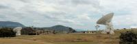
At CanberraDSN, DSS45(left) and DSS34 (right) at the start of tracking DSCOVR.
DSS35 (far right) is tracking Voyager 2.
|
|
|
|
|
|
|
Feb 12 2015, 04:01 AM
Post
#31
|
|
|
Senior Member Group: Members Posts: 2105 Joined: 13-February 10 From: Ontario Member No.: 5221 |
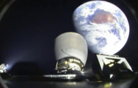
http://www.spacex.com/news/2015/02/11/spac...eep-space-orbit
 Second image from the bottom... shades of Chang'e 2's view after the translunar injection. That's Australia for sure; did you wave, Astro0? |
|
|
|
|
Feb 12 2015, 05:46 AM
Post
#32
|
||
|
Senior Member Group: Admin Posts: 3108 Joined: 21-December 05 From: Canberra, Australia Member No.: 615 |
Wow, that's an awesome image.

Cloud cover in Canberra but our dishes had a clear view
|
|
|
|
|
|
|
Feb 12 2015, 07:00 AM
Post
#33
|
|
|
Member Group: Members Posts: 184 Joined: 2-March 06 Member No.: 692 |
And what a beautifull launch. In the launch video, just after staging, you could see thrusters firing on the first stage to begin orienting it for landing. Luv those evening and morning launches.
|
|
|
|
|
Feb 12 2015, 05:05 PM
Post
#34
|
|
|
Senior Member Group: Members Posts: 1669 Joined: 5-March 05 From: Boulder, CO Member No.: 184 |
Looks like a high altitude already in the impressive image two posts up, more than the 200km "parking orbit".
-------------------- Steve [ my home page and planetary maps page ]
|
|
|
|
|
Feb 13 2015, 04:33 AM
Post
#35
|
|
|
Member Group: Members Posts: 205 Joined: 14-April 06 From: Seattle, WA Member No.: 745 |
QUOTE (Astro0 @ Feb 11 2015, 09:46 PM) Wow, that's an awesome image. Yes, it is already a favorite. For the first time a Falcon second stage looks back at Earth as it departs for heliocentric orbit. I doubt it will be the last time. |
|
|
|
|
Apr 18 2015, 01:39 AM
Post
#36
|
|
|
Member Group: Members Posts: 212 Joined: 19-July 05 Member No.: 442 |
Has there been any further news from this one?
|
|
|
|
|
Apr 18 2015, 02:09 AM
Post
#37
|
|
|
Senior Member Group: Members Posts: 2105 Joined: 13-February 10 From: Ontario Member No.: 5221 |
Still going to L1, I assumed. Last update was in February:
http://www.nesdis.noaa.gov/DSCOVR/ Early June arrival. |
|
|
|
|
Jun 8 2015, 11:17 AM
Post
#38
|
|
|
Junior Member Group: Members Posts: 39 Joined: 26-March 09 From: Cornwall Member No.: 4697 |
Should have got there today, but no news so far.
|
|
|
|
|
Jun 8 2015, 02:14 PM
Post
#39
|
|
|
Junior Member Group: Members Posts: 39 Joined: 26-March 09 From: Cornwall Member No.: 4697 |
It's got there:
http://www.nesdis.noaa.gov/news_archives/D...R_L1_orbit.html |
|
|
|
|
Jun 9 2015, 05:51 AM
Post
#40
|
|
|
Senior Member Group: Members Posts: 2105 Joined: 13-February 10 From: Ontario Member No.: 5221 |
This article has more info about the Earth-imaging:
http://spaceflightnow.com/2015/06/08/dscov...es-finish-line/ QUOTE The door to DSCOVR’s Earth-viewing camera was expected to open some time after the satellite’s arrival at L1. Its first views of Earth should be released in the coming weeks. The imager will take a full-color picture of the sunlit side of Earth every four-to-six hours, and NASA plans to post the imagery on a public website. Still no link to where they will appear; presumably there will be an announcement once they start coming down? |
|
|
|
|
Jun 9 2015, 05:00 PM
Post
#41
|
|
|
Junior Member Group: Members Posts: 78 Joined: 20-September 14 Member No.: 7261 |
NOAA hosts "daily Earth images" from its satellites on this site:
http://www.nesdis.noaa.gov/imagery_data.html For DSCOVR there's still a standby diagram instead. |
|
|
|
|
Jul 20 2015, 04:06 PM
Post
#42
|
|
|
Senior Member Group: Members Posts: 2105 Joined: 13-February 10 From: Ontario Member No.: 5221 |
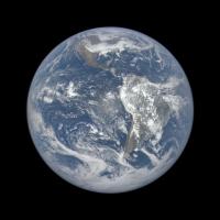
Test image released:
http://www.nasa.gov/image-feature/nasa-cap...pic-earth-image Worth the wait, I'd say! It even catches the forest fire haze blanketing my home province at the time... |
|
|
|
|
Jul 20 2015, 04:51 PM
Post
#43
|
|
|
Senior Member Group: Members Posts: 3648 Joined: 1-October 05 From: Croatia Member No.: 523 |
QUOTE This Earth image shows the effects of sunlight scattered by air molecules, giving the image a characteristic bluish tint. The EPIC team is working to remove this atmospheric effect from subsequent images. Nooooo  That's what makes images look realistic and not like yet more CGI... That's what makes images look realistic and not like yet more CGI...
-------------------- |
|
|
|
|
Jul 20 2015, 05:16 PM
Post
#44
|
|
|
Senior Member Group: Members Posts: 1669 Joined: 5-March 05 From: Boulder, CO Member No.: 184 |
Yes there is good information on aerosols and the like by seeing the true color of the Earth. I wonder if they could make both original and processed imagery available? There might be separate data or products for example that show the original radiances and processed images showing Earth's surface albedo (with atmosphere removed). I might be able to check with the folks at NOAA/NESDIS, as I have a research interest for this in my image simulations.
http://laps.noaa.gov/albers/allsky/outerspace.html -------------------- Steve [ my home page and planetary maps page ]
|
|
|
|
|
Jul 20 2015, 05:40 PM
Post
#45
|
|
|
Senior Member Group: Members Posts: 2105 Joined: 13-February 10 From: Ontario Member No.: 5221 |
Would it go through the PDS eventually, or does NOAA use a different method for data release? It's starting to get traction on social media...
|
|
|
|
|
Jul 20 2015, 09:25 PM
Post
#46
|
|
|
Senior Member Group: Members Posts: 1669 Joined: 5-March 05 From: Boulder, CO Member No.: 184 |
"EPIC makes images of the sunlit face of the Earth in 10 narrowband spectral channels. As part of EPIC data processing, a full disk true color Earth image will be produced about every two hours. This information will be publicly available through NASA Langley Research Center in Hampton, Virginia, approximately 24 hours after the images are acquired."
http://www.nesdis.noaa.gov/DSCOVR/ -------------------- Steve [ my home page and planetary maps page ]
|
|
|
|
|
Jul 20 2015, 10:04 PM
Post
#47
|
|
 Administrator Group: Admin Posts: 5172 Joined: 4-August 05 From: Pasadena, CA, USA, Earth Member No.: 454 |
QUOTE (ugordan @ Jul 20 2015, 08:51 AM) Nooooo That's what makes images look realistic and not like yet more CGI...QUOTE (scalbers @ Jul 20 2015, 09:16 AM) Yes there is good information on aerosols and the like by seeing the true color of the Earth. I wonder if they could make both original and processed imagery available? Adam Szabo confirmed to me today that they plan to release both original and processed images. Although, to be clear, they're all processed at some level. Not sure about PDS (or PDS-like) release schedule. -------------------- My website - My Patreon - @elakdawalla on Twitter - Please support unmannedspaceflight.com by donating here.
|
|
|
|
|
Jul 20 2015, 10:08 PM
Post
#48
|
|
|
Senior Member Group: Members Posts: 1669 Joined: 5-March 05 From: Boulder, CO Member No.: 184 |
Thanks Emily for the update and blog post. It's possible the raw data could be archived in NOAA's CLASS system if it is handled like some of the polar orbiter weather satellite data (e.g. NPP SUOMI).
Nice that we (and the rest of Earth's inhabitants) will then be able to see the realistic color views of Earth, complete with the air we breathe. I suppose we can also experiment with tweaks to the methods of making RGB images. The simulated imagery I linked to in post #44 has some similarities in that the 3 narrowband radiances can be convolved with the solar spectrum, then processed by determining tri-color stimulus values and using an RGB transformation matrix to produce the RGB image. -------------------- Steve [ my home page and planetary maps page ]
|
|
|
|
|
Jul 21 2015, 02:54 AM
Post
#49
|
|
|
Member Group: Members Posts: 202 Joined: 9-September 08 Member No.: 4334 |
I like seeing the real (well... closer to "real") colors.
The Caribbean is incredible... the shallows there are almost emerald-colored. |
|
|
|
|
Jul 22 2015, 05:03 PM
Post
#50
|
|
|
Senior Member Group: Members Posts: 1669 Joined: 5-March 05 From: Boulder, CO Member No.: 184 |
I now understand raw data will be available this fall via the Science Team web server.
-------------------- Steve [ my home page and planetary maps page ]
|
|
|
|
|
Jul 29 2015, 06:59 PM
Post
#51
|
|
|
Senior Member Group: Members Posts: 2105 Joined: 13-February 10 From: Ontario Member No.: 5221 |
|
|
|
|
|
Jul 29 2015, 07:34 PM
Post
#52
|
|
 Director of Galilean Photography Group: Members Posts: 896 Joined: 15-July 04 From: Austin, TX Member No.: 93 |
We do live on a beautiful world. I expect Aliens will come to visit just for the aesthetics.
-------------------- Space Enthusiast Richard Hendricks
-- "The engineers, as usual, made a tremendous fuss. Again as usual, they did the job in half the time they had dismissed as being absolutely impossible." --Rescue Party, Arthur C Clarke Mother Nature is the final inspector of all quality. |
|
|
|
|
Aug 5 2015, 02:49 PM
Post
#53
|
|
|
Member Group: Members Posts: 205 Joined: 14-April 06 From: Seattle, WA Member No.: 745 |
This is so very cool! I have been waiting to see this; didn't realize they would capture it so soon.
We live in a very beautiful system! http://www.nasa.gov/feature/goddard/from-a...g-face-of-earth |
|
|
|
|
Aug 5 2015, 03:10 PM
Post
#54
|
|
|
Senior Member Group: Members Posts: 2542 Joined: 13-September 05 Member No.: 497 |
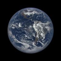
QUOTE (Ron Hobbs @ Aug 5 2015, 07:49 AM) I wonder what the source of the fringe around the Moon is? Color channel misregistration? -------------------- Disclaimer: This post is based on public information only. Any opinions are my own.
|
|
|
|
|
Aug 5 2015, 03:24 PM
Post
#55
|
|
|
Member Group: Members Posts: 929 Joined: 4-September 06 From: Boston Member No.: 1102 |
Time lag between different color images--doesn't matter as earth rotates little--bigger problem for moon flying past.
-------------------- |
|
|
|
|
Aug 5 2015, 04:45 PM
Post
#56
|
|
 Lord Of The Uranian Rings Group: Members Posts: 798 Joined: 18-July 05 From: Plymouth, UK Member No.: 437 |
My attempt to correct for the motion of the Moon, in addition to whatever processing caused blue filter signal to leak into the red and green channels:
http://postimg.org/image/6j1xbyua7/full/ -------------------- |
|
|
|
|
Aug 5 2015, 05:24 PM
Post
#57
|
|
|
Senior Member Group: Members Posts: 2105 Joined: 13-February 10 From: Ontario Member No.: 5221 |
Wow! I was actually wondering if being at L1 would allow transits to happened regularly. Apparently this is twice a year (plus the Moon being occulted two weeks before/after).
|
|
|
|
|
Aug 5 2015, 06:02 PM
Post
#58
|
|
|
Junior Member Group: Members Posts: 80 Joined: 14-February 04 Member No.: 32 |
QUOTE (Explorer1 @ Aug 5 2015, 01:24 PM) Wow! I was actually wondering if being at L1 would allow transits to happened regularly. Apparently this is twice a year (plus the Moon being occulted two weeks before/after). Fascinating... This image does give a layperson such as myself an idea of the brightness/albedo of the moon compared to earth. It is darker than I expected! -------------------- - Lars
|
|
|
|
|
Aug 5 2015, 06:09 PM
Post
#59
|
|
|
Senior Member Group: Members Posts: 1669 Joined: 5-March 05 From: Boulder, CO Member No.: 184 |
Good find on the transit. Neat that we are seeing the far side of the moon. I wonder how the lunar occultation will look in late September, when we are also having a total lunar eclipse? Will we see any of the penumbra (or even umbra) on the moon? This might depend on the fact that DSCOVR varies a bit from being exactly along the Sun - Earth line.
-------------------- Steve [ my home page and planetary maps page ]
|
|
|
|
|
Aug 6 2015, 04:38 PM
Post
#60
|
|
 Senior Member Group: Members Posts: 2173 Joined: 28-December 04 From: Florida, USA Member No.: 132 |
|
|
|
|
|
Aug 6 2015, 06:24 PM
Post
#61
|
|
|
Director of Galilean Photography Group: Members Posts: 896 Joined: 15-July 04 From: Austin, TX Member No.: 93 |
I found a reference that DSCOVR's L1 orbit varies the Sun-Earth-DSCOVR angle by 4-15*. I assume like Soho the ellipse is mostly East/West. September's eclipse is a partial in the southern hemisphere. I expect it will be difficult to notice since it will be over mostly dark water, far from the subsolar point. The March 8th total solar eclipse next year should be very noticeably, since it will cross the central Pacific. Since the umbra will stay on Earth's surface for over 3 hours, I think we should get a couple of pics of it.
http://www.timeanddate.com/eclipse/list.html -------------------- Space Enthusiast Richard Hendricks
-- "The engineers, as usual, made a tremendous fuss. Again as usual, they did the job in half the time they had dismissed as being absolutely impossible." --Rescue Party, Arthur C Clarke Mother Nature is the final inspector of all quality. |
|
|
|
|
Aug 6 2015, 06:56 PM
Post
#62
|
|
 Senior Member Group: Members Posts: 2530 Joined: 20-April 05 Member No.: 321 |
The difference between Earth-Moon albedo can also be seen in person when a gibbous Moon rises in the afternoon or sets in the morning and can be compared to distant hills, clouds, etc. on Earth, although there are many factors that can ruin the comparison.
|
|
|
|
|
Aug 6 2015, 07:57 PM
Post
#63
|
|
|
Senior Member Group: Members Posts: 1669 Joined: 5-March 05 From: Boulder, CO Member No.: 184 |
The gibbous moon is an interesting comparison. The land surface of the Earth can be relatively close to the lunar albedo, compared with the clouds. When looking at specific locations relative to the sun, we can consider the reflectance since the albedo is more of an averaged quantity. At some point I may test my rendering software to show the DSCOVR view with the moon included.
-------------------- Steve [ my home page and planetary maps page ]
|
|
|
|
|
Oct 7 2015, 12:49 AM
Post
#64
|
|
|
Senior Member Group: Members Posts: 2105 Joined: 13-February 10 From: Ontario Member No.: 5221 |
No news on the proposed daily 'pipeline'? There haven't been any images released in September at all (not trying to sounding ungrateful, just wondering about what the holdup is!)
|
|
|
|
|
Oct 20 2015, 02:02 PM
Post
#65
|
|
 Member Group: Members Posts: 555 Joined: 27-September 10 Member No.: 5458 |
Just noticed the DSCOVR website had a news update yesterday. More or less it talks about the camera on board and mentions that a new website was created to host the available data.
http://epic.gsfc.nasa.gov/ Doesn't seem to be able to finish loading for me at this moment in time however. -------------------- |
|
|
|
|
Oct 20 2015, 02:41 PM
Post
#66
|
|
 Senior Member Group: Members Posts: 3419 Joined: 9-February 04 From: Minneapolis, MN, USA Member No.: 15 |
It took me three tries to load the website yesterday, but when it finally loaded I found that I could pull up whole-Earth images from two days prior -- which happened to be my 60th birthday. It lets you scroll through images taken a few hours apart throughout a given day.
I was able to capture the image of the western hemisphere, featuring my home continent, as it appeared in the middle of my birthday. Kewl! I now have it as my desktop. -the other Doug -------------------- The trouble ain't that there is too many fools, but that the lightning ain't distributed right. -Mark Twain
|
|
|
|
|
Oct 20 2015, 03:01 PM
Post
#67
|
|
|
Member Group: Members Posts: 555 Joined: 27-September 10 Member No.: 5458 |
Yeah, it finally loaded for me as well. Probably took 10m to load the page. Either they are getting pounded with site hits or they dug up a clunker from the basement to host the site.

-------------------- |
|
|
|
|
Oct 20 2015, 04:43 PM
Post
#68
|
|
|
Senior Member Group: Members Posts: 2105 Joined: 13-February 10 From: Ontario Member No.: 5221 |
At least! Very nice, and apparently archives going back a few months. Nice to see things like the distance information and angle from the sun too.
Eventually the Moon will pass behind/in front of our blue marble again.... |
|
|
|
|
Nov 20 2015, 02:30 AM
Post
#69
|
|
|
Junior Member Group: Members Posts: 45 Joined: 27-August 14 From: Private island on Titan Member No.: 7250 |
The timing of the pictures seems really random, and the Moon transit sequence isn't included. Are we only going to get handfuls of images for the time being?
-------------------- aka the Vidiconvict
|
|
|
|
|
Nov 20 2015, 06:46 PM
Post
#70
|
|
|
Senior Member Group: Members Posts: 1669 Joined: 5-March 05 From: Boulder, CO Member No.: 184 |
Does the moon always transit as seen from DSCOVR? There's enough deviation of DSCOVR from the Sun - Earth line, and the moon's orbital inclination effect that could cause a miss.
The timing of the pictures seems to be every 2 hours or a bit less. Maybe some days they aren't downlinking as many. The website has an email contact that may help with some of our questions. -------------------- Steve [ my home page and planetary maps page ]
|
|
|
|
|
Nov 20 2015, 06:50 PM
Post
#71
|
|
|
Senior Member Group: Members Posts: 2105 Joined: 13-February 10 From: Ontario Member No.: 5221 |
I think they mentioned in the first press release on the lunar transit that it doesn't happened very often (think of eclipse frequencies). All three (Earth, Moon, DSCOVR) have to be on the same plane, so it's about twice a year.
None of the images show the Moon setting behind the Earth either, however; it might be a matter of timing the image to get the Moon in frame before and after it passes behind Earth's disc.... |
|
|
|
|
Nov 20 2015, 08:18 PM
Post
#72
|
|
|
Administrator Group: Admin Posts: 5172 Joined: 4-August 05 From: Pasadena, CA, USA, Earth Member No.: 454 |
I don't have direct answers to the questions being asked here, but I do have a little information that might be useful to people. When they first launched the website, I sent this inquiry to the media contact:
QUOTE I'm enjoying browsing the new DSCOVR EPIC website; it's a beautiful camera. I am wondering if there is a place where I can view a table or text file or something that contains basic metadata for the images (primarily a list of links to images with their timestamps). The reason I ask is because I'm interested in trying to make animations of Earth over time from a fixed longitude, but the way the website is set up, it's laborious to identify which days contain images taken at roughly the same times. Such a table would also allow people to invent different ways of displaying/searching the data. My inquiry was forwarded to Adam Szabo, who replied: QUOTE EPIC Daily "Blue Marble" API
The API URL is: http://epic.gsfc.nasa.gov/api/images.php This gets you a list of the latest day's images & metadata. OR http://epic.gsfc.nasa.gov/api/images.php?d...amp;w=X&e=Y The second form's optional parameters allow you to focus in to geographical regions that were in view (technically, longitudinal bounding points) on a given date. For instance: Using North America's boundaries of east = -53.034, and west = -170.859 and choosing August 24, 2015, the URL would look like this: http://epic.gsfc.nasa.gov/api/images.php?d...9&e=-53.034 The date parameter is unpadded(e.g. 2015-9-1, vs. 2015-09-01 for September 1, 2015), and optional. Leaving the date off will default to the latest image set. Leaving out the coordinates gets you every image for whatever date is returned. Adding either longitudinal parameter returns all images for the given date, for which the supplied longitude is in view of the camera. The JSON data looks like this: ImageData object: { "image": "epic_1b_20150826231708_00", // image name sans extension. "caption": "About an image", // Will contain a caption "coords": "{}", // Contains a JSON string representing a Coordinates object. "date": "2015-08-26 23:17:08" // The date the capture sequence for the image was initiated } ImageData notes: For the image field to be useful, it has to be added to a URL. Image URLs differ depending upon purpose. Given an image name of "epic_1b_20150901205648_00" (taken Sept 1, 2015, with the camera aimed at 3 typhoons in the pacific (my favorite)), we have: For compressed JPG thumbnails, the path would be http://epic.gsfc.nasa.gov/epic-archive/thu...01205648_00.jpg For full-size, compressed JPG previews, the path would be http://epic.gsfc.nasa.gov/epic-archive/jpg...01205648_00.jpg For full-size original PNG images, the path would http://epic.gsfc.nasa.gov/epic-archive/png...01205648_00.png Coordinates object { "centroid_coordinates": { // Geographical coordinates that the satellite is looking at "lat": 4.076132, "lon": -169.648562 }, "dscovr_j2000_position": { // Position of the satellite in space "x": -1439710.750000, "y": 659227.437500, "z": 113316.414062 }, "lunar_j2000_position": { // Position of the moon in space "x": 153199.062500, "y": -319797.531250, "z": -104905.093750 }, "sun_j2000_position": { // Position of the sun in space "x": -134918656.000000, "y": 62555808.000000, "z": 27119770.000000 }, "attitude_quaternions": { // Satellite attitude "q0": 0.976360, "q1": -0.212080, "q2": -0.039540, "q3": 0.013750 } } -------------------- My website - My Patreon - @elakdawalla on Twitter - Please support unmannedspaceflight.com by donating here.
|
|
|
|
|
Nov 28 2015, 08:22 PM
Post
#73
|
|
|
Senior Member Group: Members Posts: 2105 Joined: 13-February 10 From: Ontario Member No.: 5221 |
The seasons are changing; yesterdays image (November 27th at 12:00 GMT) is giving a sense of deja vu....
http://epic.gsfc.nasa.gov/epic-archive/png...26081200_00.png A little over a week until the anniversary of the Blue Marble that started it all. |
|
|
|
|
Dec 17 2015, 07:18 AM
Post
#74
|
|
|
Senior Member Group: Members Posts: 2105 Joined: 13-February 10 From: Ontario Member No.: 5221 |
Apparently the lunar eclipse images were saved for AGU 2015, so they weren't on the website (makes sense; the craft had to track the Moon, not Earth, so it would have been a confusing sequence).
http://www.bbc.com/news/science-environment-35076402 |
|
|
|
|
Dec 17 2015, 08:52 PM
Post
#75
|
|
|
Senior Member Group: Members Posts: 1669 Joined: 5-March 05 From: Boulder, CO Member No.: 184 |
Yes, this was shown yesterday here at AGU in a panel discussion including Al Gore, Adam Szabo and several additional science team members. It was suggested by the panel that the images from DSCOVR would look much nicer with some motion interpolation applied to make a continuous movie. Sounds right up UMSF's alley
 Also being discussed are followup missions with improved cameras. -------------------- Steve [ my home page and planetary maps page ]
|
|
|
|
|
Jan 6 2016, 05:00 PM
Post
#76
|
|
|
Junior Member Group: Members Posts: 23 Joined: 15-February 14 Member No.: 7141 |
I'd love to try some motion interpolation with these... However, I can't seem to find the actual images from the eclipse anywhere - the EPIC site still shows no images for 2015-09-27. Has anyone else been able to locate them?
|
|
|
|
|
Jan 6 2016, 05:48 PM
Post
#77
|
|
|
Administrator Group: Admin Posts: 5172 Joined: 4-August 05 From: Pasadena, CA, USA, Earth Member No.: 454 |
I haven't, either. I just sent an email and also asked about PDS release plans.
-------------------- My website - My Patreon - @elakdawalla on Twitter - Please support unmannedspaceflight.com by donating here.
|
|
|
|
|
Jan 6 2016, 07:12 PM
Post
#78
|
|
|
Administrator Group: Admin Posts: 5172 Joined: 4-August 05 From: Pasadena, CA, USA, Earth Member No.: 454 |
That was quick!
QUOTE The July 16, lunar transit mages are available at the http://epic.gsfc.nasa.gov web site.
At the top level menu, select "Galleries" and "Lunar Transit". All 20 full resolution images are there for downloading. The September 27 images will appear shortly at the same location. We are serving all of the EPIC RGB images through the http://epic.gsfc.nasa.gov site and will continue to update as new images become available. The single wavelength, Level 1b images will be made publicly available through the Langley Atmospheric Science Data Center (https://eosweb.larc.nasa.gov) our official archival site, starting in late February. Adam Szabo NASA DSCOVR Project Scientist -------------------- My website - My Patreon - @elakdawalla on Twitter - Please support unmannedspaceflight.com by donating here.
|
|
|
|
|
Jan 7 2016, 06:03 PM
Post
#79
|
|
|
Senior Member Group: Members Posts: 1669 Joined: 5-March 05 From: Boulder, CO Member No.: 184 |
I'm curious whether there is any possibility of improving the downlink capability. I understand that the red and blue channels are being reduced to 1K x 1K pixels prior to transmission to Earth. The net result is that the images we see are the equivalent of a Bayer filtered color image, even though the original images onboard are 2K x 2K RGB.
-------------------- Steve [ my home page and planetary maps page ]
|
|
|
|
|
Feb 23 2016, 07:39 PM
Post
#80
|
||
|
Senior Member Group: Members Posts: 1669 Joined: 5-March 05 From: Boulder, CO Member No.: 184 |
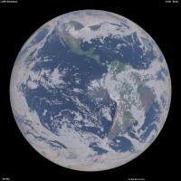
I've been doing some renderings of the Earth from increasing altitudes (up to 40000km so far), and comparing with DSCOVR imagery. I'm starting to think the DSCOVR images (have insufficient gamma correction or are too contrasty) as the ratio of green counts between bright clouds and ocean is about 6. This is between the linear and gamma corrected values. Same with blue with about a 3 or 4 ratio in the DSCOVR images. Thus the images are too contrasty between clouds & oceans compared with reality. Here is a DSCOVR image I'll elaborate on in the next post.
-------------------- Steve [ my home page and planetary maps page ]
|
|
|
|
|
|
|
Feb 24 2016, 09:48 PM
Post
#81
|
|||
|
Senior Member Group: Members Posts: 1669 Joined: 5-March 05 From: Boulder, CO Member No.: 184 |
Next we can look at the modified DSCOVR image, though only with a 0.70 gamma adjustment instead of the 0.45 I thought would be needed to generate fairly realistic results:
This can be compared with a rendering I did using 3-D cloud hydrometeor gridded data, surface albedo derived from NASA Blue Marble, and other atmospheric assumptions. The time and geometry should be pretty close. I'm still refining things like the sun glint, cloud phase function for single & multiple scattering, and atmosphere near the limb.
-------------------- Steve [ my home page and planetary maps page ]
|
||
|
|
|
||
|
Feb 27 2016, 10:00 PM
Post
#82
|
|||
|
Junior Member Group: Members Posts: 22 Joined: 7-January 13 Member No.: 6834 |
Using the automated server containing the json file of all images (here: http://epic.gsfc.nasa.gov/api/images.php), it appears that the images containing the lunar transits are not present there. Considering Emily's post, I'm not sure what it does mean. Does the folder http://epic.gsfc.nasa.gov/epic-archive/png/XXX.png contain only the non-lunar transit images ? Only featured images ? I am a bit confused, I could download more that 1800 EPIC images automatically except the most dramatic ones...
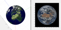
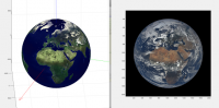
In the meantime I struggle a bit with the quaternion of the spacecract. According to it, the image should be oriented like this:
But when forcing the "up" of the image to "North" in earth frame, the image becomes inconsistant with the given quaternion but oriented as expected:
Any idea if the images were post-processed to make them point north ? |
||
|
|
|
||
|
Feb 28 2016, 05:46 PM
Post
#83
|
|
|
Senior Member Group: Members Posts: 1669 Joined: 5-March 05 From: Boulder, CO Member No.: 184 |
When I click on the first link above, I can see the 'json' file for just the most recent day's images. Generally the images I've seen are all pointing north. I wonder if they are also being centered in the frame?
-------------------- Steve [ my home page and planetary maps page ]
|
|
|
|
|
Feb 28 2016, 07:43 PM
Post
#84
|
|
|
Junior Member Group: Members Posts: 22 Joined: 7-January 13 Member No.: 6834 |
No, they are not centred and the quaternion clearly lacks of precision : the centre of the earth according to the quaternion is usually several dozens of pixels off-centre from the actual centre of the earth.
To get the json files for other dates, you just need to add the date in your query, e.g. http://epic.gsfc.nasa.gov/api/images.php?date=2016-1-12 My conclusion is that the provided quaternions are almost useless, I needed to recalculate my own. |
|
|
|
|
Feb 28 2016, 08:25 PM
Post
#85
|
|
|
Senior Member Group: Members Posts: 1669 Joined: 5-March 05 From: Boulder, CO Member No.: 184 |
Thanks for the updates. I can note that the longitude range as per this example simply shows if the box is in view. Is it possible to extract for when the centroid longitude lies within a certain range?
http://epic.gsfc.nasa.gov/api/images.php?d...9&e=-53.034 -------------------- Steve [ my home page and planetary maps page ]
|
|
|
|
|
Feb 28 2016, 10:23 PM
Post
#86
|
|
|
Senior Member Group: Members Posts: 2542 Joined: 13-September 05 Member No.: 497 |
Have you tried contacting the EPIC team about what errors you are seeing in the quaternions?
-------------------- Disclaimer: This post is based on public information only. Any opinions are my own.
|
|
|
|
|
Feb 28 2016, 10:31 PM
Post
#87
|
|
|
Junior Member Group: Members Posts: 22 Joined: 7-January 13 Member No.: 6834 |
No. I could recreate my own with a precision better than 1 pixel, so I don't need to bother them.
|
|
|
|
|
Feb 29 2016, 05:08 AM
Post
#88
|
|
|
Senior Member Group: Members Posts: 2542 Joined: 13-September 05 Member No.: 497 |
QUOTE (Stratespace @ Feb 28 2016, 02:31 PM) No. I could recreate my own with a precision better than 1 pixel, so I don't need to bother them. If you're going to say that their product is "almost useless" it only seems fair to give them an opportunity to fix it or at least explain what the issue is. -------------------- Disclaimer: This post is based on public information only. Any opinions are my own.
|
|
|
|
|
Feb 29 2016, 01:37 PM
Post
#89
|
|
|
Junior Member Group: Members Posts: 22 Joined: 7-January 13 Member No.: 6834 |
It's almost useless to me, I don't want to make them think that what they propose is "bad" or anything like this. The rest of the metadata is pretty good and useful to me.
As long as I could find absolutely no documentation on the quaternion (frame definition, where is the scalar and the vector, etc) I had to guess everything by my own. I finally found what I thought is correct, then I deduced that I was not useful to me... I am very far to question the intrinsic value of the quaternion they propose, maybe for example it is not supposed to represent directly the orientation of the image. Anyway, I don't feel the "right" nor the confidence to contact people that have other things to do that being bothered by someone from the other side of the planet, who speaks poor english, who just plays a bit with the data they are very kind to propose and who maybe doesn't understand what is proposed to him due to lack of information. If you feel well doing it, please feel free to do it. |
|
|
|
|
Feb 29 2016, 02:14 PM
Post
#90
|
|
|
Merciless Robot Group: Admin Posts: 8785 Joined: 8-December 05 From: Los Angeles Member No.: 602 |
Stratespace, I think that the EPIC team might actually appreciate the inquiry. I don't think that you would offend them (and it's obvious that's not your intent at all), and feedback from users of their products would doubtless be valuable.
-------------------- A few will take this knowledge and use this power of a dream realized as a force for change, an impetus for further discovery to make less ancient dreams real.
|
|
|
|
|
Feb 29 2016, 05:10 PM
Post
#91
|
|
|
Administrator Group: Admin Posts: 5172 Joined: 4-August 05 From: Pasadena, CA, USA, Earth Member No.: 454 |
I checked the website and it looks like they've shifted the date for the availability of the archival data from "end of February" to "spring 2016". There is a mailing list you can be signed up for to be notified of project status.
-------------------- My website - My Patreon - @elakdawalla on Twitter - Please support unmannedspaceflight.com by donating here.
|
|
|
|
|
Feb 29 2016, 08:23 PM
Post
#92
|
|
|
Senior Member Group: Members Posts: 1669 Joined: 5-March 05 From: Boulder, CO Member No.: 184 |
Yes I think this leap day qualifies as the end of February
QUOTE (nprev @ Feb 29 2016, 02:14 PM) Stratespace, I think that the EPIC team might actually appreciate the inquiry. I don't think that you would offend them (and it's obvious that's not your intent at all), and feedback from users of their products would doubtless be valuable. Generally I think it's difficult for spacecraft attitude information to be accurate enough to navigate image position to the pixel level. I also end up simply fitting empirically (and somewhat automatically) to the limb within the image. Might be nice though for them to know about our discussions in general. -------------------- Steve [ my home page and planetary maps page ]
|
|
|
|
|
Feb 29 2016, 11:05 PM
Post
#93
|
|
|
Junior Member Group: Members Posts: 22 Joined: 7-January 13 Member No.: 6834 |
For the first images in particular, the quaternion attitude error is much more than 1 pixel, even sometime more than 1 Field of View !
My observations are: - The "Earth north is toward image top" is roughly true, but not exactly. There is always are ~1° to 5° typically (with peaks at more than 15°) error between real north and image "up". - The latest the images, the best their orientation wrt north. - Some images a completely black, for some reason. - There are long missing periods in the data that we know exist. - There is uncorrected or residual image distortion. I could struggle estimate the polynomials, but it would be a lot of effort for a faint effect (~1 to 2 pixels). I could re-calculate the quaternion according to what is visible in the images, update the image "up" toward a more accurate "north", and when corrected everything seems much prettier. I'll try to post a video showing this result. |
|
|
|
|
Mar 1 2016, 08:31 PM
Post
#94
|
|
|
Junior Member Group: Members Posts: 22 Joined: 7-January 13 Member No.: 6834 |
Here we are:
https://www.youtube.com/watch?v=V5YZnXZs_v4 This is not intended to be beautiful nor pleasant to see, but just to provide an idea of what is possible in terms of projection after the metadata has been a bit "improved". |
|
|
|
|
Mar 1 2016, 09:43 PM
Post
#95
|
|
|
Administrator Group: Admin Posts: 5172 Joined: 4-August 05 From: Pasadena, CA, USA, Earth Member No.: 454 |
Wacky. Sort of like passing by time on a subway train. But a cool start to something; I'm looking forward to where you go with this.
-------------------- My website - My Patreon - @elakdawalla on Twitter - Please support unmannedspaceflight.com by donating here.
|
|
|
|
|
Mar 1 2016, 09:46 PM
Post
#96
|
|
|
Senior Member Group: Members Posts: 2105 Joined: 13-February 10 From: Ontario Member No.: 5221 |
Yes, very cool! The gradual season change is so clearly evident, as are individual storm systems. Keep it up!
|
|
|
|
|
Mar 1 2016, 11:55 PM
Post
#97
|
|
|
Junior Member Group: Members Posts: 22 Joined: 7-January 13 Member No.: 6834 |
Ok, I've just put a bit of persistence on the map, so you won't need no aspirin when watching this.
But there is so much work yet to do to calibrate both the extrinsic and intrinsic parameters of each image, it is a bit discouraging... particularly considering all the processing already applied on the image. I find it much easier to play with classical raw PDS images ! https://youtu.be/7N63ucC1lXY I'll need to find those parameters, and then tune some image morphing algorithms. I've already tested some of them on those images, and they provide poor result. |
|
|
|
|
Mar 4 2016, 02:07 AM
Post
#98
|
|
|
Junior Member Group: Members Posts: 22 Joined: 7-January 13 Member No.: 6834 |
As the morphing software didn't give me what I wanted, I designed an algorithm (based on some publications) dedicated to image temporal interpolation for planetary images (understand: it can deal with clouds warping, tearing and whirling).
The next video is based on only 2 images, processed in a fully automatic way (not a single command nor help brought to the algorithm, except "run"): - Image 1: http://epic.gsfc.nasa.gov/epic-archive/png...07130002_00.png - Image 2: http://epic.gsfc.nasa.gov/epic-archive/png...08130501_00.png Result is this video (Watch in HD): https://youtu.be/M2CiR4WCaPo Please tell me if you find it satisfactory... or not. |
|
|
|
|
Mar 4 2016, 07:11 PM
Post
#99
|
|
|
Senior Member Group: Members Posts: 1669 Joined: 5-March 05 From: Boulder, CO Member No.: 184 |
Interesting to see, though a day is a long time to interpolate clouds for. I wonder how the Butterflow algorithm that Dan Delany has been showing us would do with this? This can somewhat be validated by comparing the interpolated DSCOVR frames with actual DSCOVR or Himawari frames that were remapped. Will be interesting to see how the time interpolation in post #98 can be applied to the movie shown earlier, including between frames just an hour or two apart.
BTW, a bit of a gap in real-time DSCOVR images, so we'll see when they can start to get some updates. -------------------- Steve [ my home page and planetary maps page ]
|
|
|
|
|
Mar 4 2016, 08:18 PM
Post
#100
|
|
|
Junior Member Group: Members Posts: 22 Joined: 7-January 13 Member No.: 6834 |
Yes, obviously the objective is to run it on the map with all frames. But the 1-day gap seemed to be a good benchmark as a worst case scenario.
|
|
|
|
 |

|
Lo-Fi Version | Time is now: 20th September 2024 - 12:23 AM |
|
RULES AND GUIDELINES Please read the Forum Rules and Guidelines before posting. IMAGE COPYRIGHT |
OPINIONS AND MODERATION Opinions expressed on UnmannedSpaceflight.com are those of the individual posters and do not necessarily reflect the opinions of UnmannedSpaceflight.com or The Planetary Society. The all-volunteer UnmannedSpaceflight.com moderation team is wholly independent of The Planetary Society. The Planetary Society has no influence over decisions made by the UnmannedSpaceflight.com moderators. |
SUPPORT THE FORUM Unmannedspaceflight.com is funded by the Planetary Society. Please consider supporting our work and many other projects by donating to the Society or becoming a member. |
|