DSCOVR |

  |
DSCOVR |
 Jan 6 2016, 05:00 PM Jan 6 2016, 05:00 PM
Post
#76
|
|
 Junior Member  Group: Members Posts: 23 Joined: 15-February 14 Member No.: 7141 |
I'd love to try some motion interpolation with these... However, I can't seem to find the actual images from the eclipse anywhere - the EPIC site still shows no images for 2015-09-27. Has anyone else been able to locate them?
|
 |
 
|
|
Jan 6 2016, 05:48 PM
Post
#77
|
|
 Administrator Group: Admin Posts: 5172 Joined: 4-August 05 From: Pasadena, CA, USA, Earth Member No.: 454 |
I haven't, either. I just sent an email and also asked about PDS release plans.
-------------------- My website - My Patreon - @elakdawalla on Twitter - Please support unmannedspaceflight.com by donating here.
|
|
|
|
|
Jan 6 2016, 07:12 PM
Post
#78
|
|
|
Administrator Group: Admin Posts: 5172 Joined: 4-August 05 From: Pasadena, CA, USA, Earth Member No.: 454 |
That was quick!
QUOTE The July 16, lunar transit mages are available at the http://epic.gsfc.nasa.gov web site.
At the top level menu, select "Galleries" and "Lunar Transit". All 20 full resolution images are there for downloading. The September 27 images will appear shortly at the same location. We are serving all of the EPIC RGB images through the http://epic.gsfc.nasa.gov site and will continue to update as new images become available. The single wavelength, Level 1b images will be made publicly available through the Langley Atmospheric Science Data Center (https://eosweb.larc.nasa.gov) our official archival site, starting in late February. Adam Szabo NASA DSCOVR Project Scientist -------------------- My website - My Patreon - @elakdawalla on Twitter - Please support unmannedspaceflight.com by donating here.
|
|
|
|
|
Jan 7 2016, 06:03 PM
Post
#79
|
|
 Senior Member Group: Members Posts: 1630 Joined: 5-March 05 From: Boulder, CO Member No.: 184 |
I'm curious whether there is any possibility of improving the downlink capability. I understand that the red and blue channels are being reduced to 1K x 1K pixels prior to transmission to Earth. The net result is that the images we see are the equivalent of a Bayer filtered color image, even though the original images onboard are 2K x 2K RGB.
-------------------- Steve [ my home page and planetary maps page ]
|
|
|
|
|
Feb 23 2016, 07:39 PM
Post
#80
|
||
|
Senior Member Group: Members Posts: 1630 Joined: 5-March 05 From: Boulder, CO Member No.: 184 |
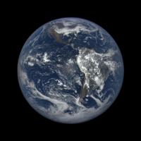
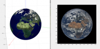
I've been doing some renderings of the Earth from increasing altitudes (up to 40000km so far), and comparing with DSCOVR imagery. I'm starting to think the DSCOVR images (have insufficient gamma correction or are too contrasty) as the ratio of green counts between bright clouds and ocean is about 6. This is between the linear and gamma corrected values. Same with blue with about a 3 or 4 ratio in the DSCOVR images. Thus the images are too contrasty between clouds & oceans compared with reality. Here is a DSCOVR image I'll elaborate on in the next post.
-------------------- Steve [ my home page and planetary maps page ]
|
|
|
|
|
|
|
Feb 24 2016, 09:48 PM
Post
#81
|
|||
|
Senior Member Group: Members Posts: 1630 Joined: 5-March 05 From: Boulder, CO Member No.: 184 |
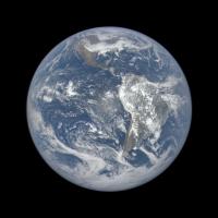
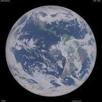
Next we can look at the modified DSCOVR image, though only with a 0.70 gamma adjustment instead of the 0.45 I thought would be needed to generate fairly realistic results:
This can be compared with a rendering I did using 3-D cloud hydrometeor gridded data, surface albedo derived from NASA Blue Marble, and other atmospheric assumptions. The time and geometry should be pretty close. I'm still refining things like the sun glint, cloud phase function for single & multiple scattering, and atmosphere near the limb.
-------------------- Steve [ my home page and planetary maps page ]
|
||
|
|
|
||
|
Feb 27 2016, 10:00 PM
Post
#82
|
|||
|
Junior Member Group: Members Posts: 22 Joined: 7-January 13 Member No.: 6834 |
Using the automated server containing the json file of all images (here: http://epic.gsfc.nasa.gov/api/images.php), it appears that the images containing the lunar transits are not present there. Considering Emily's post, I'm not sure what it does mean. Does the folder http://epic.gsfc.nasa.gov/epic-archive/png/XXX.png contain only the non-lunar transit images ? Only featured images ? I am a bit confused, I could download more that 1800 EPIC images automatically except the most dramatic ones...
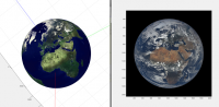
In the meantime I struggle a bit with the quaternion of the spacecract. According to it, the image should be oriented like this:
But when forcing the "up" of the image to "North" in earth frame, the image becomes inconsistant with the given quaternion but oriented as expected:
Any idea if the images were post-processed to make them point north ? |
||
|
|
|
||
|
Feb 28 2016, 05:46 PM
Post
#83
|
|
|
Senior Member Group: Members Posts: 1630 Joined: 5-March 05 From: Boulder, CO Member No.: 184 |
When I click on the first link above, I can see the 'json' file for just the most recent day's images. Generally the images I've seen are all pointing north. I wonder if they are also being centered in the frame?
-------------------- Steve [ my home page and planetary maps page ]
|
|
|
|
|
Feb 28 2016, 07:43 PM
Post
#84
|
|
|
Junior Member Group: Members Posts: 22 Joined: 7-January 13 Member No.: 6834 |
No, they are not centred and the quaternion clearly lacks of precision : the centre of the earth according to the quaternion is usually several dozens of pixels off-centre from the actual centre of the earth.
To get the json files for other dates, you just need to add the date in your query, e.g. http://epic.gsfc.nasa.gov/api/images.php?date=2016-1-12 My conclusion is that the provided quaternions are almost useless, I needed to recalculate my own. |
|
|
|
|
Feb 28 2016, 08:25 PM
Post
#85
|
|
|
Senior Member Group: Members Posts: 1630 Joined: 5-March 05 From: Boulder, CO Member No.: 184 |
Thanks for the updates. I can note that the longitude range as per this example simply shows if the box is in view. Is it possible to extract for when the centroid longitude lies within a certain range?
http://epic.gsfc.nasa.gov/api/images.php?d...9&e=-53.034 -------------------- Steve [ my home page and planetary maps page ]
|
|
|
|
|
Feb 28 2016, 10:23 PM
Post
#86
|
|
|
Senior Member Group: Members Posts: 2511 Joined: 13-September 05 Member No.: 497 |
Have you tried contacting the EPIC team about what errors you are seeing in the quaternions?
-------------------- Disclaimer: This post is based on public information only. Any opinions are my own.
|
|
|
|
|
Feb 28 2016, 10:31 PM
Post
#87
|
|
|
Junior Member Group: Members Posts: 22 Joined: 7-January 13 Member No.: 6834 |
No. I could recreate my own with a precision better than 1 pixel, so I don't need to bother them.
|
|
|
|
|
Feb 29 2016, 05:08 AM
Post
#88
|
|
|
Senior Member Group: Members Posts: 2511 Joined: 13-September 05 Member No.: 497 |
QUOTE (Stratespace @ Feb 28 2016, 02:31 PM)  No. I could recreate my own with a precision better than 1 pixel, so I don't need to bother them. If you're going to say that their product is "almost useless" it only seems fair to give them an opportunity to fix it or at least explain what the issue is. -------------------- Disclaimer: This post is based on public information only. Any opinions are my own.
|
|
|
|
|
Feb 29 2016, 01:37 PM
Post
#89
|
|
|
Junior Member Group: Members Posts: 22 Joined: 7-January 13 Member No.: 6834 |
It's almost useless to me, I don't want to make them think that what they propose is "bad" or anything like this. The rest of the metadata is pretty good and useful to me.
As long as I could find absolutely no documentation on the quaternion (frame definition, where is the scalar and the vector, etc) I had to guess everything by my own. I finally found what I thought is correct, then I deduced that I was not useful to me... I am very far to question the intrinsic value of the quaternion they propose, maybe for example it is not supposed to represent directly the orientation of the image. Anyway, I don't feel the "right" nor the confidence to contact people that have other things to do that being bothered by someone from the other side of the planet, who speaks poor english, who just plays a bit with the data they are very kind to propose and who maybe doesn't understand what is proposed to him due to lack of information. If you feel well doing it, please feel free to do it. |
|
|
|
|
Feb 29 2016, 02:14 PM
Post
#90
|
|
|
Merciless Robot Group: Admin Posts: 8783 Joined: 8-December 05 From: Los Angeles Member No.: 602 |
Stratespace, I think that the EPIC team might actually appreciate the inquiry. I don't think that you would offend them (and it's obvious that's not your intent at all), and feedback from users of their products would doubtless be valuable.
-------------------- A few will take this knowledge and use this power of a dream realized as a force for change, an impetus for further discovery to make less ancient dreams real.
|
|
|
|
|

|
Lo-Fi Version | Time is now: 29th April 2024 - 12:48 AM |
|
RULES AND GUIDELINES Please read the Forum Rules and Guidelines before posting. IMAGE COPYRIGHT |
OPINIONS AND MODERATION Opinions expressed on UnmannedSpaceflight.com are those of the individual posters and do not necessarily reflect the opinions of UnmannedSpaceflight.com or The Planetary Society. The all-volunteer UnmannedSpaceflight.com moderation team is wholly independent of The Planetary Society. The Planetary Society has no influence over decisions made by the UnmannedSpaceflight.com moderators. |
SUPPORT THE FORUM Unmannedspaceflight.com is funded by the Planetary Society. Please consider supporting our work and many other projects by donating to the Society or becoming a member. |
|