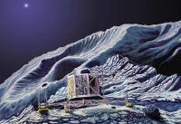
Philae landing on the nucleus of Comet 67P C-G |

Philae landing on the nucleus of Comet 67P C-G |
 Sep 23 2014, 12:16 PM Sep 23 2014, 12:16 PM
Post
#1
|
||
 Senior Member  Group: Members Posts: 1088 Joined: 19-February 05 From: Close to Meudon Observatory in France Member No.: 172 |
Now, it's time to open a new section devoted to the landing of the Philae lander itself on the nucleus of Comet 67P C-G. Also to answer better the earlier post, http://www.unmannedspaceflight.com/index.p...st&p=212943 and for your information, here is the quick summary (as a "pdf" file) of the events that are expected to occur during landing on the nucleus and after : it's the timeschedule on which we are working to set up our EPO event in Paris.  Sequence_ATTERRISSAGE10_UMSF.pdf ( 263.81K )
Number of downloads: 4555
Sequence_ATTERRISSAGE10_UMSF.pdf ( 263.81K )
Number of downloads: 4555The landing itself should occur around November 11th. We'll keep you informed 
|
|
 |
 
|
|
 |
|
Sep 23 2014, 02:14 PM
Post
#2
|
|
|
Junior Member Group: Members Posts: 31 Joined: 3-August 14 From: Germany Member No.: 7229 |
Great information, thank you!!
ROLIS will take nadir images all the way down from the separation to landing and I am sure the images will be of high scientific values, but as I am reading in the document, the images will be uplinked to Rosetta only after touchdown. Was there no way to transmit the images as quickly as possible, without waiting for the landing? -------------------- space scout
|
|
|
|
|
Sep 23 2014, 02:41 PM
Post
#3
|
|
|
Solar System Cartographer Group: Members Posts: 10166 Joined: 5-April 05 From: Canada Member No.: 227 |
The idea of transmitting images during the descent has been considered before, even as far back as the Surveyor landings on the Moon, and including Phoenix on Mars (actually, Phoenix MARDI images were not to be transmitted live, just transferred into the flight computer, and even that was too much of a risk).
Every time it has been abandoned because of the number and complexity of other operations at the same time. Phil -------------------- ... because the Solar System ain't gonna map itself.
Also to be found posting similar content on https://mastodon.social/@PhilStooke Maps for download (free PD: https://upload.wikimedia.org/wikipedia/comm...Cartography.pdf NOTE: everything created by me which I post on UMSF is considered to be in the public domain (NOT CC, public domain) |
|
|
|
|
Sep 23 2014, 03:40 PM
Post
#4
|
|
|
Senior Member Group: Members Posts: 1088 Joined: 19-February 05 From: Close to Meudon Observatory in France Member No.: 172 |
QUOTE (SpaceScout @ Sep 23 2014, 04:14 PM)  Great information, thank you!! ROLIS will take nadir images all the way down from the separation to landing and I am sure the images will be of high scientific values, but as I am reading in the document, the images will be uplinked to Rosetta only after touchdown. Was there no way to transmit the images as quickly as possible, without waiting for the landing? Dear SpaceScout, thank you for your kind comments. Considering the great involvement of Germany in this mission, I should have put the timeschedule in German also, but my writing with Goethe's style is somewhat shaky : all my apologizes ! Yes, Phil is right : ESA does not want to interefere through the instructions with the transmitting of data during the landing phase. Sorry : so we will have to wait for the ROLIS images after a safe landing on the nucleus. |
|
|
|
|
Sep 23 2014, 04:44 PM
Post
#5
|
|
|
Solar System Cartographer Group: Members Posts: 10166 Joined: 5-April 05 From: Canada Member No.: 227 |
I just realized that I forgot about Chang'E 3 in my comments above. We did have spectacular video of the descent and landing. But I realized - I don't know if that was transmitted during or after landing.
Phil -------------------- ... because the Solar System ain't gonna map itself.
Also to be found posting similar content on https://mastodon.social/@PhilStooke Maps for download (free PD: https://upload.wikimedia.org/wikipedia/comm...Cartography.pdf NOTE: everything created by me which I post on UMSF is considered to be in the public domain (NOT CC, public domain) |
|
|
|
|
Sep 23 2014, 05:51 PM
Post
#6
|
|
|
Senior Member Group: Members Posts: 2086 Joined: 13-February 10 From: Ontario Member No.: 5221 |
I think it was halfway; I recall the streamed images were received at a much lower rate then the final landing movie; either only some were released on the live stream or only some were transmitted during the sequence.
Ok, found it: Here is the live stream recording: https://www.youtube.com/watch?v=jyg56VIKRNA And the 'complete' video: https://www.youtube.com/watch?v=XNAGFTRvgDY To not derail too far; what will be sent from Philae during the descent if not images; there will be some telemetry? |
|
|
|
|
Sep 23 2014, 06:00 PM
Post
#7
|
|
|
Junior Member Group: Members Posts: 31 Joined: 3-August 14 From: Germany Member No.: 7229 |
QUOTE (Phil Stooke @ Sep 23 2014, 04:41 PM) Every time it has been abandoned because of the number and complexity of other operations at the same time. If I am getting this right, is the high number of processes that the computer needs to handle during descent (although is free fall) that prevent transmitting images ? Will Philae transmit live any telemetry at all to Rosetta before touchdown? I am just thinking about the improvements that could be made for a next generation landing probe... 
-------------------- space scout
|
|
|
|
|
Sep 23 2014, 06:15 PM
Post
#8
|
|
|
Member Group: Members Posts: 148 Joined: 9-August 11 From: Mason, TX Member No.: 6108 |
QUOTE (SpaceScout @ Sep 23 2014, 12:00 PM) If I am getting this right, is the high number of processes that the computer needs to handle during descent (although is free fall) that prevent transmitting images ? Will Philae transmit live any telemetry at all to Rosetta before touchdown? I am just thinking about the improvements that could be made for a next generation landing probe... This is an interesting paper on the original conceptual design of Philae--from 1997! (just to remind ourselves of the era for which available stable technologies were being considered, and what incredible now-stable things might be in a next-gen lander) http://www.open.ac.uk/personalpages/a.j.ba...ine/capcom.html No descent imaging was even described in that paper, so the present capability and operational plan is a privilege, considering. Whole careers go by in the course of one such mission! -------------------- --
Don |
|
|
|
|
Sep 23 2014, 06:47 PM
Post
#9
|
|
|
Founder Group: Chairman Posts: 14432 Joined: 8-February 04 Member No.: 1 |
I don't believe they'll be taking a lot of descent images....indeed, there's not much point. OSIRIS resolution will out-perform that of the descent imaging until we're pretty close to the surface. One before bettering OSIRIS res , one at some intermediate point, one just before touch-down.....that would be enough for a very good localization.
|
|
|
|
|
Sep 23 2014, 08:29 PM
Post
#10
|
|
|
Senior Member Group: Members Posts: 1088 Joined: 19-February 05 From: Close to Meudon Observatory in France Member No.: 172 |
QUOTE (djellison @ Sep 23 2014, 08:47 PM) I don't believe they'll be taking a lot of descent images....indeed, there's not much point. OSIRIS resolution will out-perform that of the descent imaging until we're pretty close to the surface .../... Yes, Doug : indeed ! OSIRIS has a far better resolution than ROLIS from orbit. This is why ROLIS will take just a few images during the descent. BUT at a low altitude (i.e. tens of meters from the surface) and until touchdown, it will start taking one image every 5 seconds... |
|
|
|
|
Sep 23 2014, 10:04 PM
Post
#11
|
|
 Member Group: Members Posts: 796 Joined: 27-February 08 From: Heart of Europe Member No.: 4057 |
Original plan was (and it looks still is) to take few images after release from Rosetta and then few images before landing.
"Few" means up to 8 images. -------------------- |
|
|
|
|
Sep 24 2014, 03:21 AM
Post
#12
|
|
 Member Group: Members Posts: 444 Joined: 1-July 05 From: New York City Member No.: 424 |
QUOTE (Phil Stooke @ Sep 23 2014, 10:41 AM) The idea of transmitting images during the descent has been considered before, even as far back as the Surveyor landings on the Moon, and including Phoenix on Mars (actually, Phoenix MARDI images were not to be transmitted live, just transferred into the flight computer, and even that was too much of a risk). Every time it has been abandoned because of the number and complexity of other operations at the same time. Phil The Ranger moon spacecraft perforce transmitted images during descent, because there wasn't any afterwards, but I can't think of any others. Well, maybe NEAR, if you call the whole approach a descent because the spacecraft eventually touched down, but that would be whimsical. Can't think of any others, but of course I don't have the encyclopaedic recall of the two Dougs. |
|
|
|
|
Sep 24 2014, 03:42 AM
Post
#13
|
|
 Senior Member Group: Members Posts: 1431 Joined: 26-July 08 Member No.: 4270 |
MSL did a whole descent movie. MER did a couple descent images if I recall right.
Edit: Nevermind. The discussion was about transmitting them during descent rather than storing and transmission later. -------------------- -- Hungry4info (Sirius_Alpha)
|
|
|
|
|
Sep 24 2014, 03:47 AM
Post
#14
|
|
|
Senior Member Group: Members Posts: 2086 Joined: 13-February 10 From: Ontario Member No.: 5221 |
And don't forget Huygens!
It's true that discussing why Huygens transmitted pictures on the way down and Philae won't is comparing apples and oranges (one had atmospheric observations as the primary objective with landing as a bonus, while the other is exclusively a lander), but there is a precedent of descent imaging from ESA. |
|
|
|
|
Sep 24 2014, 03:51 AM
Post
#15
|
|
|
Senior Member Group: Members Posts: 1431 Joined: 26-July 08 Member No.: 4270 |
QUOTE (Explorer1 @ Sep 23 2014, 10:47 PM) ...there is a precedent of descent imaging from ESA. Was there anything similar planned for Beagle 2? -------------------- -- Hungry4info (Sirius_Alpha)
|
|
|
|
|
Sep 24 2014, 04:11 AM
Post
#16
|
|
|
Member Group: Members Posts: 148 Joined: 9-August 11 From: Mason, TX Member No.: 6108 |
QUOTE (Hungry4info @ Sep 23 2014, 10:51 PM) Was there anything similar planned for Beagle 2? Beagle's airbag-wrapped landing process precluded the need for descent imaging. But this discussion is drifting from the subject of Philae itself. Philae will be a free-falling object without the ability to use the descent images for terrain avoidance; figuring out where it landed after the fact is much more important, so deferred imaging is fine. The issue is less about precedents than about requirements for the mission, with science and engineering both as stakeholders in the outcome. -------------------- --
Don |
|
|
|
|
Sep 24 2014, 04:20 AM
Post
#17
|
|
|
Senior Member Group: Members Posts: 2086 Joined: 13-February 10 From: Ontario Member No.: 5221 |
A big difference from Beagle 2 is that OSIRIS will be able to resolve Philae on the surface right away, so even loss of contact would be a learning experience. This will not be a shot in the dark.
|
|
|
|
|
Sep 24 2014, 03:37 PM
Post
#18
|
|
|
Junior Member Group: Members Posts: 31 Joined: 3-August 14 From: Germany Member No.: 7229 |
QUOTE (Explorer1 @ Sep 24 2014, 06:20 AM) [...] so even loss of contact would be a learning experience. This will not be a shot in the dark. and I think this is the most important point. Whatever happen to the lander, it will be possible to reconstruct its approach and touchdown. -------------------- space scout
|
|
|
|
|
Sep 24 2014, 05:37 PM
Post
#19
|
|
|
Solar System Cartographer Group: Members Posts: 10166 Joined: 5-April 05 From: Canada Member No.: 227 |
One aspect of landing which I don't think has been mentioned is that it takes 7 hours for the lander to descend from release to the surface. That's over half a rotation. So it's not like hovering over the landing site and letting go - the landing site is far away, and as the lander falls the landing site moves until, at the appointed time, it's just under the lander. Like one of those action movies where somebody jumps off a bridge to land on the top of the train car as it passes underneath ... only a bit slower. It's easy to see that any uncertainty in the descent rate translates into a change in location on the surface.
Phil -------------------- ... because the Solar System ain't gonna map itself.
Also to be found posting similar content on https://mastodon.social/@PhilStooke Maps for download (free PD: https://upload.wikimedia.org/wikipedia/comm...Cartography.pdf NOTE: everything created by me which I post on UMSF is considered to be in the public domain (NOT CC, public domain) |
|
|
|
|
Sep 24 2014, 06:12 PM
Post
#20
|
|
|
Senior Member Group: Members Posts: 1088 Joined: 19-February 05 From: Close to Meudon Observatory in France Member No.: 172 |
QUOTE (Phil Stooke @ Sep 24 2014, 07:37 PM) One aspect of landing which I don't think has been mentioned is that it takes 7 hours for the lander to descend from release to the surface. That's over half a rotation. So it's not like hovering over the landing site and letting go - the landing site is far away, and as the lander falls the landing site moves until, at the appointed time, it's just under the lander. Like one of those action movies where somebody jumps off a bridge to land on the top of the train car as it passes underneath ... only a bit slower. It's easy to see that any uncertainty in the descent rate translates into a change in location on the surface. Phil Well seen Phil ! This is not a descent, but a low-speed free-fall, hoping that the lander will not gain too much horizontal velocity at touchdown... PS : the 7 hrs descent, from "T0" to "T0 + 7h", was duly mentioned inside the "PDF" timetable attached to the 1st post  |
|
|
|
|
Sep 24 2014, 06:51 PM
Post
#21
|
|
 Senior Member Group: Members Posts: 2173 Joined: 28-December 04 From: Florida, USA Member No.: 132 |
I'm wondering what percent of Phillae's descent rate is due to the mechanical push toward the comet it receives and how much is due to gravity and how that changes over the course of the descent. Has this been described?
Edit: After some more reading and thought, I've concluded that the mechanical shove is almost entirely devoted to counteracting orbital velocity (and not to push the lander toward the comet) and that the descent is pretty much 100% due to gravity. |
|
|
|
|
Sep 24 2014, 07:49 PM
Post
#22
|
|
|
Senior Member Group: Members Posts: 1074 Joined: 21-September 07 From: Québec, Canada Member No.: 3908 |
Is there an animation somewhere that shows the complete Philae landing sequence, including the comet rotating in the background? From the descriptions I read, I can't figure out how exactly it's going to work out.
|
|
|
|
|
Sep 24 2014, 08:42 PM
Post
#23
|
|
|
Senior Member Group: Members Posts: 2346 Joined: 7-December 12 Member No.: 6780 |
QUOTE (vikingmars @ Sep 23 2014, 05:40 PM) ... I should have put the timeschedule in German also, but my writing with Goethe's style is somewhat shaky : all my apologizes ! ... Far from competing with Goethe (I'm sure he would be excited by the mission), here my amateur translation of your appreciated survey into German:  philae_landing_schedule_de_utf8.txt ( 2.96K )
Number of downloads: 1322
philae_landing_schedule_de_utf8.txt ( 2.96K )
Number of downloads: 1322 |
|
|
|
|
Sep 25 2014, 12:08 AM
Post
#24
|
|
|
Forum Contributor Group: Members Posts: 1372 Joined: 8-February 04 From: North East Florida, USA. Member No.: 11 |
QUOTE (charborob @ Sep 24 2014, 07:49 PM) Is there an animation somewhere that shows the complete Philae landing sequence, including the comet rotating in the background? .. Yes, it's at 12:40 on this presentation, the comet actually hits the lander, albeit softly. If they did not have the hold down thruster, the harpoons and screws on the legs the lander would bounce away from the comet. Landing Site Announcement. |
|
|
|
|
Sep 25 2014, 03:11 AM
Post
#25
|
|
|
Senior Member Group: Members Posts: 1074 Joined: 21-September 07 From: Québec, Canada Member No.: 3908 |
That's exactly what I wanted to see. Thanks. Unfortunately, I didn't have the time to watch the presentation.
|
|
|
|
|
Sep 25 2014, 07:12 AM
Post
#26
|
||
|
Senior Member Group: Members Posts: 1088 Joined: 19-February 05 From: Close to Meudon Observatory in France Member No.: 172 |
QUOTE (Gerald @ Sep 24 2014, 10:42 PM) Far from competing with Goethe (I'm sure he would be excited by the mission), here my amateur translation of your appreciated survey into German:
philae_landing_schedule_de_utf8.txt ( 2.96K )
Number of downloads: 1322Thanks a lot Gerald for this nice work ! I keep the German translation in my records. We may have also some German visitors in Cite des Sciences in Paris and they may like some documentation in German too (I'll put your name as translator then)...
"Goethe mit uns" |
|
|
|
|
|
|
Sep 26 2014, 01:09 AM
Post
#27
|
|
 Member Group: Members Posts: 495 Joined: 12-February 12 Member No.: 6336 |
Landing site J with C as backup if they spot anything untoward on the first selection.'
(Edit: Since I heard it verbally I got it wrong still think they really said 'G'.) |
|
|
|
|
Sep 26 2014, 03:14 PM
Post
#28
|
||
|
Senior Member Group: Members Posts: 1088 Joined: 19-February 05 From: Close to Meudon Observatory in France Member No.: 172 |
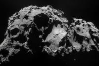
A new set of 2 Rosetta NavCam images was released this afternoon by the Rosetta team... (sorry, again, no OSIRIS images).
This NavCam image is a very interesting one : it shows the backup "C" landing ellipse (see the superimposed yellow ellipse I draw on the left-hand side of the image)... Wow ! Look carefully at it : its the only "safe" place around, among truly chaotic terrain ! What a GREAT mission indeed
|
|
|
|
|
|
|
Sep 26 2014, 10:28 PM
Post
#29
|
|
|
Senior Member Group: Members Posts: 2346 Joined: 7-December 12 Member No.: 6780 |
The timing of the landing options has been pinned down for November 12 (GMT) :
QUOTE Two robust landing scenarios have been identified, one for the primary site and one for the backup. Both anticipate separation and landing on 12 November. For the primary landing scenario, targeting Site J, Rosetta will release Philae at 08:35 GMT/09:35 CET at a distance of 22.5 km from the centre of the comet, landing about seven hours later. The one-way signal travel time between Rosetta and Earth on 12 November is 28 minutes 20 seconds, meaning that confirmation of the landing will arrive at Earth ground stations at around 16:00 GMT/17:00 CET. If a decision is made to use the backup Site C, separation will occur at 13:04 GMT/14:04 CET, 12.5 km from the centre of the comet. Landing will occur about four hours later, with confirmation on Earth at around 17:30 GMT/18:30 CET. The timings are subject to uncertainties of several minutes. The 22.5 km look rather distant. I'm not quite sure about the reason. Might be it turned out, that Philae is more predictable than Rosetta regarding drag due to outgassing? Or it has something to do with the observability of Philae during the descent and communication early after landing. |
|
|
|
|
Sep 26 2014, 11:10 PM
Post
#30
|
|
|
Forum Contributor Group: Members Posts: 1372 Joined: 8-February 04 From: North East Florida, USA. Member No.: 11 |
QUOTE (Gerald @ Sep 26 2014, 11:28 PM) The 22.5 km look rather distant. Remember you do not want the orbiter to accidentally hit the comet too, so someone decided 22.5 km was the distance to use. |
|
|
|
|
Sep 27 2014, 01:54 AM
Post
#31
|
|
|
Member Group: Members Posts: 148 Joined: 9-August 11 From: Mason, TX Member No.: 6108 |
The latest NavCam composite shows that the left (main lobe) side of the valley seems to have cliffs with deep shadows, possibly vents. Now, seeing the line of boulders in the valley, I have a more distinct impression of gases from both sides of the valley impinging in the middle, creating on one hand a zone of stagnated velocities in which levitated boulders could lose escape velocity and drop down along that preferential zone, and on the other hand forming a plane of converged gas and dust. That plane would appear like a jet along the zone of impingement, and appear diffuse when viewed away from that plane. Just a thought, but it could explain why single sources for the "jets" have not been clearly identified yet, and why they appear variable based on direction.
-------------------- --
Don |
|
|
|
|
Sep 27 2014, 03:12 AM
Post
#32
|
|
|
Solar System Cartographer Group: Members Posts: 10166 Joined: 5-April 05 From: Canada Member No.: 227 |
That idea of jets forming where two or more broad cones of emission meet, channeling dust into sheets (two cones) or collimated jets (three cones) was referred to earlier in our discussions and originated with Jean Crifo 20 years ago (Icarus, 1995, v. 116, pp. 77-112).
Phil -------------------- ... because the Solar System ain't gonna map itself.
Also to be found posting similar content on https://mastodon.social/@PhilStooke Maps for download (free PD: https://upload.wikimedia.org/wikipedia/comm...Cartography.pdf NOTE: everything created by me which I post on UMSF is considered to be in the public domain (NOT CC, public domain) |
|
|
|
|
Sep 27 2014, 04:28 AM
Post
#33
|
|
|
Member Group: Members Posts: 148 Joined: 9-August 11 From: Mason, TX Member No.: 6108 |
Thanks for the reminder, Phil. All very easy to visualize now.
-------------------- --
Don |
|
|
|
|
Oct 15 2014, 01:19 PM
Post
#34
|
|
 Senior Member Group: Members Posts: 1729 Joined: 3-August 06 From: 43° 35' 53" N 1° 26' 35" E Member No.: 1004 |
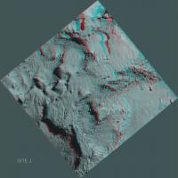
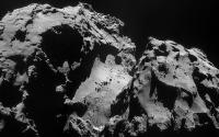
Site J confirmed as the landing site: ESA confirms the primary landing site for Rosetta
and we are given another image (actually a mosaic of two) from OSIRIS. (ADMIN EDIT)
|
|
|
|
|
Oct 15 2014, 01:44 PM
Post
#35
|
|
|
Forum Contributor Group: Members Posts: 1372 Joined: 8-February 04 From: North East Florida, USA. Member No.: 11 |
It's not exactly flat is it ?
Those cliffs have to be at least 20 feet high ? |
|
|
|
|
Oct 15 2014, 03:56 PM
Post
#36
|
||
|
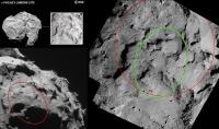
Senior Member Group: Members Posts: 2173 Joined: 28-December 04 From: Florida, USA Member No.: 132 |
On the left, the original ESA landing oval in white and my red ovals on the other two images. On the right, ESA's red circle marking landing site J on the latest image (rotated) with my green oval marking where I think the original ESA white oval would be located.
|
|
|
|
|
|
|
Oct 15 2014, 06:15 PM
Post
#37
|
|
 Senior Member Group: Members Posts: 4247 Joined: 17-January 05 Member No.: 152 |
It's not clear these are landing error ellipses, since I couldn't see any such description in the captions of either image. The caption of the latest image just says
QUOTE The circle is centred on the landing site and is approximately 500 m in diameter. The cross marking the central landing position in the old image is pretty close (but not exactly) at the centre of the new red circle. There's no way to know if that's just plotting error or a slight adjustment in the central position. |
|
|
|
|
Oct 16 2014, 07:42 AM
Post
#38
|
|
|
Junior Member Group: Members Posts: 31 Joined: 3-August 14 From: Germany Member No.: 7229 |
I have not seen this very high close up of the landing site J posted here, so here is the image in full resolution. Many wonderful details! thank you ESA
-------------------- space scout
|
|
|
|
|
Oct 16 2014, 11:32 AM
Post
#39
|
|
|
Solar System Cartographer Group: Members Posts: 10166 Joined: 5-April 05 From: Canada Member No.: 227 |
http://blogs.esa.int/rosetta/2014/10/16/la...tes-from-30-km/
The individual images for the Osiris mosaic of the landing area are here, plus - very nice - two images for site C as well. Phil -------------------- ... because the Solar System ain't gonna map itself.
Also to be found posting similar content on https://mastodon.social/@PhilStooke Maps for download (free PD: https://upload.wikimedia.org/wikipedia/comm...Cartography.pdf NOTE: everything created by me which I post on UMSF is considered to be in the public domain (NOT CC, public domain) |
|
|
|
|
Oct 16 2014, 02:49 PM
Post
#40
|
||
|
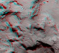
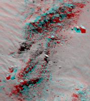
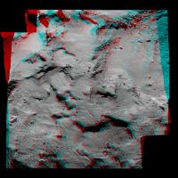
Senior Member Group: Members Posts: 4247 Joined: 17-January 05 Member No.: 152 |
Primary landing site in anaglyph stereo. There are severe distortions here and I've only done a quick a dirty job aligning the frames, so this may be headache-inducing:
|
|
|
|
|
|
|
Oct 16 2014, 02:50 PM
Post
#41
|
||
|
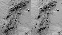
Senior Member Group: Members Posts: 4247 Joined: 17-January 05 Member No.: 152 |
And cross-eyed:
|
|
|
|
|
|
|
Oct 16 2014, 03:06 PM
Post
#42
|
|||
|
Senior Member Group: Members Posts: 4247 Joined: 17-January 05 Member No.: 152 |
And a better-aligned crop of a scarp, showing precariously perched boulders/protrusions that couldn't exist in Earth-like gravity. Anaglyph:
Cross-eyed:
|
||
|
|
|
||
|
Oct 16 2014, 03:25 PM
Post
#43
|
|
|
Senior Member Group: Members Posts: 2921 Joined: 14-February 06 From: Very close to the Pyrénées Mountains (France) Member No.: 682 |
I'm wondering how far we'll see once on the ground. If we were to land on a perfectly flat surface, horizon would be very very close I believe, but on THIS, it's hard to predict anything.
-------------------- |
|
|
|
|
Oct 17 2014, 07:15 AM
Post
#44
|
||
|
Newbie Group: Members Posts: 14 Joined: 7-August 12 From: California Member No.: 6489 |
QUOTE (Phil Stooke @ Oct 16 2014, 04:32 AM) http://blogs.esa.int/rosetta/2014/10/16/la...tes-from-30-km/ The individual images for the Osiris mosaic of the landing area are here, plus - very nice - two images for site C as well. Phil Here's my version of a site J anaglyph...
|
|
|
|
|
|
|
Oct 17 2014, 11:15 AM
Post
#45
|
|
|
Forum Contributor Group: Members Posts: 1372 Joined: 8-February 04 From: North East Florida, USA. Member No.: 11 |
QUOTE (climber @ Oct 16 2014, 04:25 PM) I'm wondering how far we'll see once on the ground... If we see something, it's going to be awesome. I would guess the horizon would be 300 meters away or so. The jets though should be something else. |
|
|
|
|
Oct 17 2014, 05:28 PM
Post
#46
|
|
|
Junior Member Group: Members Posts: 78 Joined: 20-September 14 Member No.: 7261 |
QUOTE (climber @ Oct 16 2014, 05:25 PM) horizon would be very very close I believe More so because the CIVA-P cameras are mounted tilted 15 degrees downwards. |
|
|
|
|
Oct 25 2014, 10:17 AM
Post
#47
|
||
|
Senior Member Group: Members Posts: 1088 Joined: 19-February 05 From: Close to Meudon Observatory in France Member No.: 172 |
For those interested to attend this historic landing and take this opportunity to fly to Paris (and pay us a visit : TPS / UMSF Members, please, tell us in advance), here below is the link to the only other official ESA/CNES event set-up for the landing of Philae (with the one held in ESOC in Darmstadt). As you may know, the engineering of the Philae lander is under the responsibility of CNES (the French Space Agency), as well as its CIVA cameras and instruments suite. This event will take place at the National Science Museum (Cite des Sciences) in Paris : http://www.cite-sciences.fr/fr/au-programm...-sur-la-comete/ ...and thanks again for your kind support over all those nice comments and posts ! Enjoy ! PS : Societe Astronomique de France is the partner of TPS in France since 1982
|
|
|
|
|
|
|
Oct 25 2014, 12:48 PM
Post
#48
|
|
|
Junior Member Group: Members Posts: 32 Joined: 3-May 04 From: mes pieds à Paris, mon coeur dans les Pyrénées, mon esprit dans l'Espace Member No.: 72 |
Bonjour Olivier !
Faut-il s'inscrire ? Même s'il faut attendre pour y participer, j'y serai ! Cdt |
|
|
|
|
Oct 25 2014, 11:10 PM
Post
#49
|
|
|
Senior Member Group: Members Posts: 1088 Joined: 19-February 05 From: Close to Meudon Observatory in France Member No.: 172 |
QUOTE (polaris @ Oct 25 2014, 02:48 PM) Bonjour Olivier ! Faut-il s'inscrire ? Même s'il faut attendre pour y participer, j'y serai ! Cdt Thanks a lot, Polaris Please, try to arrive at 14:00 at the latest... And name you : I'll try to arrange so that you are well seated ! Friendly yours, VM
|
|
|
|
|
Oct 28 2014, 02:24 PM
Post
#50
|
|
|
Member Group: Members Posts: 107 Joined: 1-August 14 Member No.: 7227 |
QUOTE (Phil Stooke @ Sep 23 2014, 03:41 PM) The idea of transmitting images during the descent has been considered before, even as far back as the Surveyor landings on the Moon, and including Phoenix on Mars (actually, Phoenix MARDI images were not to be transmitted live, just transferred into the flight computer, and even that was too much of a risk). Every time it has been abandoned because of the number and complexity of other operations at the same time. Why can't they just use a separated and standalone camera to take snapshots during landing? If it works, that's fine, else, who cares? Is there a detailed 3d model of the landing site available for 3d printing? I already printed the comet model, but the landing site detailed 3d model would fit well close to it on my desktop. :-) |
|
|
|
|
Oct 28 2014, 02:27 PM
Post
#51
|
|
|
Founder Group: Chairman Posts: 14432 Joined: 8-February 04 Member No.: 1 |
QUOTE (mcgyver @ Oct 28 2014, 06:24 AM) Why can't they just use a separated and standalone camera to take snapshots during landing? If it works, that's fine, else, who cares? They do. The challenge is offloading the data thru the flight computer to be transmitted back up to Rosetta and from there on to Earth - all whilst the flight computer is trying to land. |
|
|
|
|
Oct 28 2014, 02:44 PM
Post
#52
|
|
|
Member Group: Members Posts: 107 Joined: 1-August 14 Member No.: 7227 |
QUOTE (djellison @ Oct 28 2014, 03:27 PM) They do. The challenge is offloading the data thru the flight computer to be transmitted back up to Rosetta and from there on to Earth - all whilst the flight computer is trying to land. This remembers me of the infamous 1201 and 1202 alarms. Unfortunately there won't be any human onboard Philae, so actually delayed transmission is better!Anyways it's really incredible to see how electronics evolved during mission journey!  |
|
|
|
|
Oct 28 2014, 03:22 PM
Post
#53
|
|
 Senior Member Group: Members Posts: 3419 Joined: 9-February 04 From: Minneapolis, MN, USA Member No.: 15 |
As Curiosity demonstrated, though, it is quite possible (with modern electronics) to take descent images, store them and send them back to Earth later, when the landing sequence is *not* making the lander too busy to add the image transmission to its duties.
I would hope that planetary landers from now into the future will have this capability. It's not just valuable for developing context of the landing site within the general area, it also has the highest "cool factor" of any part of the missions, IMHO. -the other Doug (With my shield, not yet upon it) -------------------- The trouble ain't that there is too many fools, but that the lightning ain't distributed right. -Mark Twain
|
|
|
|
|
Oct 28 2014, 04:05 PM
Post
#54
|
|
|
Member Group: Members Posts: 107 Joined: 1-August 14 Member No.: 7227 |
QUOTE (dvandorn @ Oct 28 2014, 04:22 PM) I would hope that planetary landers from now into the future will have this capability. What I really hope/expect from future missions is HD video-shooting capability, rather than 1 Frame Per DAY "videos" ! Processor power and storage space are no more a mass/space issue, even if you'd enclose processor and RAM inside a lead box 3 mm thick! (Who cares if it will take years to send HD data back to earth? One day or the other they'll eventually arrive)What was available on the (space) market in 1993 (date of mission acceptance) for onboard processing power and data storage? 10 MHz and 10 MB? 
|
|
|
|
|
Oct 28 2014, 04:36 PM
Post
#55
|
|
|
Founder Group: Chairman Posts: 14432 Joined: 8-February 04 Member No.: 1 |
QUOTE (mcgyver @ Oct 28 2014, 08:05 AM) (Who cares if it will take years to send HD data back to earth? One day or the other they'll eventually arrive) There's a few issues with what you're saying. Firstly - Rosetta is taking a lot lot more than 1 frame per day..... that's simply what's being released at the moment. Once all this data is delivered to ESA's PSA - there will be hundreds of image of 67P that people will be able to turn into pretty amazing animations. And who cares how long it might take to downlink an HD video? Well actually - all the scientists and engineers entrusted with operating Rosetta and doing science with it. The amount of data it's possible to return from the somewhere as far as 67P is a massive constraint on operations. It's not a question of taking an HD camera, or processing it's data...it's getting it back to Earth. A rough calculation: 90 second of highly compressed 720p video is around 170 Megabytes. At typical data rates from Rosetta - that would take 8 HOURS to download from the spacecraft. That represents pretty much an entire day's downlink from a typical deep space spacecraft. And for what? An HD video 90 seconds long that, to be honest, would be better represented by a few 2k x 2k still images anyway - and you would have given up all the other scientific measurements Rosetta could take that day. These spacecraft do not last for ever. It's wrong to assume data will somehow magically make it to Earth eventually. Curiosity is capable of, and indeed has taken HD video from the surface of Mars - but only on a few very specific, very select and very rare occasions, for the same reasons - the quantity of data it's possible to return from deep space is a massive, massive constraint. Kaguya at lunar distances was capable of, and indeed did return many HD movies of the moon where the data rate doesn't represent such a constraint ( typical downlink from lunar orbit is more than 2,000 times faster than Rosetta right now. |
|
|
|
|
Oct 28 2014, 06:02 PM
Post
#56
|
|
|
Junior Member Group: Members Posts: 32 Joined: 3-May 04 From: mes pieds à Paris, mon coeur dans les Pyrénées, mon esprit dans l'Espace Member No.: 72 |
Many thanks, Olivier !
I'll be there, right in time ! |
|
|
|
|
Oct 29 2014, 12:44 AM
Post
#57
|
||
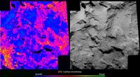
 Member Group: Members Posts: 241 Joined: 22-August 05 From: Stockholm Sweden Member No.: 468 |
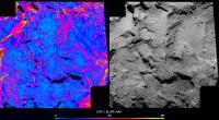
I made a slopemap of site J using my terrain-model. (I'm assuming that the center of rotation is the gravityvector for the surface)
Cyan=good Red=bad |
|
|
|
|
|
|
Oct 29 2014, 12:47 AM
Post
#58
|
||
|
Member Group: Members Posts: 241 Joined: 22-August 05 From: Stockholm Sweden Member No.: 468 |
And an anaglyph of J using the same terrainmodel.
|
|
|
|
|
|
|
Oct 29 2014, 09:13 AM
Post
#59
|
|
|
Junior Member Group: Members Posts: 31 Joined: 3-August 14 From: Germany Member No.: 7229 |
QUOTE (Malmer @ Oct 29 2014, 01:44 AM) Cyan=good Red=bad Great work! It looks promising for Philae. Can you tell us how much percent represent the "cyan=good" (<few degree) area? -------------------- space scout
|
|
|
|
|
Oct 29 2014, 09:50 AM
Post
#60
|
|
|
Member Group: Members Posts: 194 Joined: 8-February 04 Member No.: 10 |
'An HD video 90 seconds long that, to be honest, would be better represented by a few 2k x 2k still images anyway'
There may well be dynamics that only video will show, something to keep in mind for a future comet probe. I think of water dumps from old live feeds on NASA TV. 'Curiosity is capable of, and indeed has taken HD video from the surface of Mars - but only on a few very specific, very select and very rare occasions, for the same reasons' It seems a waste to have capability that isn't used. I wonder what the minimum time between 'RGB' filtered frames is for Rosetta? If the interval is brief enough there should be color images of the comet. They can eventually be used to help add color to lander images. |
|
|
|
|
Oct 29 2014, 10:13 AM
Post
#61
|
||
|
Member Group: Members Posts: 241 Joined: 22-August 05 From: Stockholm Sweden Member No.: 468 |
Another surface feature map I made to try to understand the obstacles Philae faces.
I have no real unit for surface roughness. (is there one?) but it is clear that you want to land in the blue areas.
|
|
|
|
|
|
|
Oct 29 2014, 10:15 AM
Post
#62
|
|
|
Member Group: Members Posts: 107 Joined: 1-August 14 Member No.: 7227 |
QUOTE (Malmer @ Oct 29 2014, 01:44 AM) I made a slopemap of site J I'd like to make an elevation map, but I can't find any suitable free program. I tried a couple of "disparity map generators", but I get ugly results... DMAG, StereoPlus... what else could I use? I already 3d-printed the whole comet, now I'd like to 3d-print the landing site too, before landing happens! |
|
|
|
|
Oct 29 2014, 10:30 AM
Post
#63
|
|
|
Member Group: Members Posts: 241 Joined: 22-August 05 From: Stockholm Sweden Member No.: 468 |
QUOTE (mcgyver @ Oct 29 2014, 11:15 AM) I'd like to make an elevation map, but I can't find any suitable free program. I tried a couple of "disparity map generators", but I get ugly results... DMAG, StereoPlus... what else could I use? I already 3d-printed the whole comet, now I'd like to 3d-print the landing site too, before landing happens! You have to have a resonable disparity generator. preferrably one that understands the two cameras orientation in respect to eachother. (or you will have to bring the pictures into alignment with some other software.) then you will have to tweak and tweak until you have the best possible settings. Then you will probably get something that is resonably ok on a mid to global scale. there will still be local noise. To combat that I would suggest that you use shape from shading to capture the fine details. |
|
|
|
|
Oct 29 2014, 10:31 AM
Post
#64
|
||
|
Senior Member Group: Members Posts: 1088 Joined: 19-February 05 From: Close to Meudon Observatory in France Member No.: 172 |
QUOTE (Malmer @ Oct 29 2014, 01:44 AM) I made a slopemap of site J using my terrain-model. (I'm assuming that the center of rotation is the gravityvector for the surface) Cyan=good Red=bad Thanks a lot Mattias for this very, very good work of yours ! If fact, we are not on Mars and there is not such a big number of 'bad' slopes, because in such a low-gravity object, we may 'land' in an hi-degree slope and stay there without sliding 'downwards', because we will screw into it. On the other hand, and because of such an eventuality, there is a strong possibility that the CIVA panorama looks very, very tilted with little horizon to be seen. Anyway, the horizon is so close that most of the interest of the CIVA images is in the looking 'downwards' to see tiny ground features around the lander that may sublimate/evaporate/move as we are closing to the Sun...
|
|
|
|
|
|
|
Oct 29 2014, 12:29 PM
Post
#65
|
|
|
Member Group: Members Posts: 241 Joined: 22-August 05 From: Stockholm Sweden Member No.: 468 |
QUOTE (vikingmars @ Oct 29 2014, 11:31 AM) Thanks a lot Mattias for this very, very good work of yours ! If fact, we are not on Mars and there is not such a big number of 'bad' slopes, because in such a low-gravity object, we may 'land' in an hi-degree slope and stay there without sliding 'downwards', because we will screw into it. On the other hand, and because of such an eventuality, there is a strong possibility that the CIVA panorama looks very, very tilted with little horizon to be seen. Anyway, the horizon is so close that most of the interest of the CIVA images is in the looking 'downwards' to see tiny ground features around the lander that may sublimate/evaporate/move as we are closing to the Sun... Happy to be of service! I'm more worried about the rough boulder fields. I think those are more troublesome than just a slope. But it is hard for me to really say much about. I would like the 10Km OSIRIS look of the area. I made my roughness map to get a feel for the different areas. Thankfully there is a lot of blue there. (and landing in a red area could with some luck work just as well) |
|
|
|
|
Oct 29 2014, 12:34 PM
Post
#66
|
|
|
Senior Member Group: Members Posts: 2346 Joined: 7-December 12 Member No.: 6780 |
QUOTE (Malmer @ Oct 29 2014, 12:13 PM) I have no real unit for surface roughness. (is there one?) ... There are several measures of surface roughness, most of them related to the usual statistical techniques to describe a distribution. It's mostly about amplitudes in a hipass version of a DTM, or by applying the shape by shading philosophy and assuming constant albedo, about amplitudes of the brightness in a hipass version of the greyscale image. Dimension will be length in many cases, unit in meters, e.g. for the standard deviation; for variance it would be square meters. You could now correlate those surface roughness values with probabilities for successful landings, to provide a probability map of successful landing constrained to the surface roughness aspect. Adding slope etc. to a simulation of landings could provide an overall probability map for successful landing with Monte Carlo methods as the underlying principle. Besides geometric surface properties, the consistence of the material will play a key role for successful anchoring. |
|
|
|
|
Oct 29 2014, 01:04 PM
Post
#67
|
|
|
Senior Member Group: Members Posts: 1088 Joined: 19-February 05 From: Close to Meudon Observatory in France Member No.: 172 |
QUOTE (Malmer @ Oct 29 2014, 01:29 PM) Happy to be of service! I'm more worried about the rough boulder fields. Absolutely agree with you Mattias. The big boulders are of a real concern, because : - they may made the lander touch them and flip over upon arrival ; - the lander may not be able to screw into them ; - the lander body may land on the very top of a boulder (big or small) and its landing mechanism may not be able to fold down enough on its sides to get a grip on it and/or the soil... It's really going to be a tough landing anyway ! |
|
|
|
|
Oct 29 2014, 01:12 PM
Post
#68
|
|
|
Member Group: Members Posts: 107 Joined: 1-August 14 Member No.: 7227 |
QUOTE (Malmer @ Oct 29 2014, 11:30 AM) You have to have a resonable disparity generator. preferrably one that understands the two cameras orientation in respect to eachother. (or you will have to bring the pictures into alignment with some other software.) Isn't an anaglyph enough? It is already aligned and I can extract images from it with StereoPhotoMaker. http://www.esa.int/var/esa/storage/images/...ull_image_2.png |
|
|
|
|
Oct 29 2014, 01:15 PM
Post
#69
|
|
|
Member Group: Members Posts: 107 Joined: 1-August 14 Member No.: 7227 |
QUOTE (Malmer @ Oct 29 2014, 01:44 AM) using my terrain-model. Is it available to the public? |
|
|
|
|
Oct 29 2014, 01:47 PM
Post
#70
|
|
|
Junior Member Group: Members Posts: 31 Joined: 1-July 13 From: Ithaca, NY Member No.: 6966 |
Questions from an interested non-expert:
I have read that Philae may still partly function if it lands in the wrong orientation (lying on its side, or similar). Is there the possibility that Philae may bounce off the surface, or even not contact the surface? In either of these scenarios, would Philae still be able to transmit back whatever data or images it has already taken? Is there a scenario other than spacecraft system failure where Philae would not be able to transmit data back (like landing upside down, perhaps)? Thanks. |
|
|
|
|
Oct 29 2014, 02:02 PM
Post
#71
|
|
|
Senior Member Group: Members Posts: 1088 Joined: 19-February 05 From: Close to Meudon Observatory in France Member No.: 172 |
QUOTE (blake @ Oct 29 2014, 02:47 PM) Questions from an interested non-expert: I have read that Philae may still partly function if it lands in the wrong orientation (lying on its side, or similar). Is there the possibility that Philae may bounce off the surface, or even not contact the surface? In either of these scenarios, would Philae still be able to transmit back whatever data or images it has already taken? Is there a scenario other than spacecraft system failure where Philae would not be able to transmit data back (like landing upside down, perhaps)? Thanks. Good question. The landing site is so chaotic... Franckly we don't know : so mainy possibilities of failures and so many possibility of successes... What is certain is that as soon as it touches the ground, the lander tries to screw its footpads into it and there is a small engine on top of it that pushes it downwards to maintain a contact as long as the grip is not firmy done... We'll know for sure in what shape the lander is upon arrival on the 12th ! Hope for the best !
|
|
|
|
|
Oct 29 2014, 04:09 PM
Post
#72
|
|
|
Senior Member Group: Members Posts: 2346 Joined: 7-December 12 Member No.: 6780 |
QUOTE (blake @ Oct 29 2014, 03:47 PM) In either of these scenarios, would Philae still be able to transmit back whatever data or images it has already taken? Is there a scenario other than spacecraft system failure where Philae would not be able to transmit data back (like landing upside down, perhaps)? NSSDC about Philae: QUOTE The lander will communicate with the Rosetta spacecraft via a 1 W S-band transmitter. S-band communication usually is rather tolerant in terms of pointing. Although I didn't find reliable information about whether the (two?) Philae S-band antennas (at least taken together) are omnidirectional. The other instruments may shield the radio waves in some directions. But if Philae doesn't vanish in some deep gap, I'm optimistic, that communication will be possible in some directions, at least, as long as the batteries are charged. Most descent data will be transmitted before touchdown; thus we'll get some infos of the descent phase, at least. |
|
|
|
|
Oct 29 2014, 05:14 PM
Post
#73
|
|
|
Senior Member Group: Members Posts: 4247 Joined: 17-January 05 Member No.: 152 |
QUOTE (Malmer @ Oct 29 2014, 01:44 AM) (I'm assuming that the center of rotation is the gravityvector for the surface) What do you mean by "centre of rotation"? What point do you point the gravity vectors to? I suppose that for these purposes, and without a mass distribution model, you could choose that point such that some average slope over the area of the plot is close to zero. Of course that may not be very accurately true. |
|
|
|
|
Oct 29 2014, 05:42 PM
Post
#74
|
|
|
Founder Group: Chairman Posts: 14432 Joined: 8-February 04 Member No.: 1 |
QUOTE (Gerald @ Oct 29 2014, 09:09 AM) S-band communication usually is rather tolerant in terms of pointing. Whilst the lower frequencies are less fussy regarding pointing - the predominant factor in required pointing accuracy is antenna design - NOT frequency. The S-Band relay from Huygens to Cassini had a beamwidth of only 2.3-2.4 degrees because it used Cassini's HGA. http://descanso.jpl.nasa.gov/DPSummary/Des...3--Cassini2.pdf ( page 8 ) Whereas Deep Impact's probe-flyby relay used S-Band but patch-antennas that were in essence omnidirectional and managed 64kbps downlink at 8,000km range. |
|
|
|
|
Oct 29 2014, 06:00 PM
Post
#75
|
|
|
Senior Member Group: Members Posts: 1431 Joined: 26-July 08 Member No.: 4270 |
Great new, close-up image of that smoothe area on the "bottom" of the larger lobe. Looks like they also give us a mosaic, too.
http://www.esa.int/spaceinimages/Images/20..._October_NavCam -------------------- -- Hungry4info (Sirius_Alpha)
|
|
|
|
|
Oct 29 2014, 06:35 PM
Post
#76
|
|
|
Senior Member Group: Members Posts: 2086 Joined: 13-February 10 From: Ontario Member No.: 5221 |
If tweets are any evidence, we might be getting separation images from both Philae and Rosetta! I'm assuming it would be with NAVCAM? Osiris would be tough to focus that close...
https://twitter.com/ESA_Rosetta/status/527460959657689088 And some COSIMA results: http://blogs.esa.int/rosetta/2014/10/29/co...n-called-boris/ |
|
|
|
|
Oct 29 2014, 08:56 PM
Post
#77
|
|
|
Member Group: Members Posts: 241 Joined: 22-August 05 From: Stockholm Sweden Member No.: 468 |
QUOTE (Gerald @ Oct 29 2014, 01:34 PM) There are several measures of surface roughness, Thank you Gerald for all the good info! QUOTE (mcgyver @ Oct 29 2014, 02:12 PM) Isn't an anaglyph enough? It is already aligned and I can extract images from it with StereoPhotoMaker. http://www.esa.int/var/esa/storage/images/...ull_image_2.png You can obviously build a disparity map from that image. (I made a shape-model of that very anaglyph a while back) but you will not know the actual height of anything unless you also know the camera positions. you get only relative heights. you can download that old one from here if you like: http://classic.syndicate.se/image/space/Landingsitemodel.zip QUOTE (mcgyver @ Oct 29 2014, 02:15 PM) Is it available to the public? The new one is much better. I have the camera positions and all that good stuff reverse enginnered so it is an absolute map. (it matches my Global shapemodel) will post it when it is more finalized. QUOTE (fredk @ Oct 29 2014, 06:14 PM) What do you mean by "centre of rotation"? What point do you point the gravity vectors to? I suppose that for these purposes, and without a mass distribution model, you could choose that point such that some average slope over the area of the plot is close to zero. Of course that may not be very accurately true. I'm simply aiming my gravity vector towards the center of mass of the comet (the point it is rotating around) I did some simple tests with my global shape model. I fill it with particles and let them gravitationally affect an external point. At the top of the comet the gravity vector is pointing mostly towards the center of gravity of the comet anyway. There are areas in the neck area that have gravity vectors pointing slightly of to one side or the other but it is not by a huge deal. (I'm assuming a homogeneous comet with no mass concentrations because of lack of data) I also did not factor in the spinning. (to much math for one night) I'm so excited about the landing. I really hope it works out well. There is so much science to be gained if it works as planned. I made my maps to try to get a feel for the chances. I think it looks really promising. There are very few really steep slopes in the area. And there are big areas of very few boulders. (at the scale of this picture) About those flat dust plains. Is there any reason to fear that the dust would be very soft and that the lander would just sink? |
|
|
|
|
Oct 29 2014, 09:21 PM
Post
#78
|
|
|
Senior Member Group: Members Posts: 3516 Joined: 4-November 05 From: North Wales Member No.: 542 |
Sinking under its own weight is unlikely as it will weigh very little. (It could potentially dig itself in with its landing motor maybe?) I think a bigger problem might be attaching to dust with screws.
|
|
|
|
|
Oct 29 2014, 09:44 PM
Post
#79
|
|
|
Founder Group: Chairman Posts: 14432 Joined: 8-February 04 Member No.: 1 |
It's not surface 'weight' that's the problem ( about 11 grams by my rough calculations - 0.01 Newtons )
It's the impact of landing. 1m/sec to a dead stop in, say, 20cm..... is a 5m/sec/sec deceleration - which is 500N of deceleration force for the 100kg Philae: 50,000x higher than the resting surface weight. |
|
|
|
|
Oct 29 2014, 11:04 PM
Post
#80
|
|
|
Member Group: Members Posts: 241 Joined: 22-August 05 From: Stockholm Sweden Member No.: 468 |
QUOTE (djellison @ Oct 29 2014, 10:44 PM) It's not surface 'weight' that's the problem ( about 11 grams by my rough calculations - 0.01 Newtons ) It's the impact of landing. 1m/sec to a dead stop in, say, 20cm..... is a 5m/sec/sec deceleration - which is 500N of deceleration force for the 100kg Philae: 50,000x higher than the resting surface weight. ...or in the words of xkcd: http://xkcd.com/89/ |
|
|
|
|
Oct 30 2014, 02:05 AM
Post
#81
|
|
|
Senior Member Group: Members Posts: 4247 Joined: 17-January 05 Member No.: 152 |
QUOTE (Malmer @ Oct 29 2014, 09:56 PM) I'm simply aiming my gravity vector towards the center of mass of the comet (the point it is rotating around) A body doesn't rotate around a point, it rotates about an axis. So you have to decide where on that axis your gravity vectors point to. The centre of mass (COM) calculated assuming uniform density is probably a good first approximation to the gravitational field direction. It would be very interesting to see how close the uniform-density COM is to the rotation axis. That would tell you something about how good the uniform-density approximation is, since (I believe) the COM will lie on the rotation axis for a body that actually has uniform density. |
|
|
|
|
Oct 30 2014, 04:10 AM
Post
#82
|
||
|
Junior Member Group: Members Posts: 70 Joined: 12-November 06 Member No.: 1354 |
Thank you for the wonderful image in http://www.unmannedspaceflight.com/index.p...st&p=213418 vikingmars! With a bit of cropping and resizing I was able to make quite a dramatic wallpaper for my computer.
After staring at it for many days I realized that I was having a hard time grasping the scale of what I was looking at. I've spent some time looking at the scale of the many followup photos and came to the conclusion that the boulders(?) in the rift/conjunction valley(?) must be around 2 to 5 meters. Is this in the ballpark? |
|
|
|
|
|
|
Oct 30 2014, 05:17 AM
Post
#83
|
|
|
Senior Member Group: Members Posts: 2173 Joined: 28-December 04 From: Florida, USA Member No.: 132 |
While awaiting more expert input, I would say the largest is about 20 meters.
|
|
|
|
|
Oct 30 2014, 09:49 AM
Post
#84
|
|
|
Member Group: Members Posts: 241 Joined: 22-August 05 From: Stockholm Sweden Member No.: 468 |
QUOTE (fredk @ Oct 30 2014, 03:05 AM) A body doesn't rotate around a point, it rotates about an axis. So you have to decide where on that axis your gravity vectors point to. Thats true, I stand corrected... Anyway, I did not factor in rotation... so then the center of mass was the simplest point to choose. I also did not calculate my own center of mass. I used the center of the coordinate system that ESA used for this VIRTIS map as my center of mass... http://mattias.malmer.nu/wp-content/upload...IS_LAT_LONG.jpg I will try to do a new map where I calculate the effects of rotation and local gravity. then I can do a dot product between the vectors and see if the difference is much to talk about... (the J site is almost on the equator so the rotation should not make all that much difference. J has most of the mass centered under it so the deflection of the gravity vector is not going to be too aggressive either.) Interesting stuff... |
|
|
|
|
Nov 1 2014, 04:15 PM
Post
#85
|
|
|
Junior Member Group: Members Posts: 40 Joined: 28-July 07 Member No.: 2984 |
QUOTE (fredk @ Oct 29 2014, 09:05 PM) A body doesn't rotate around a point, it rotates about an axis. Actually, to be super-pedantic about it (sorry, can't resist) rotations are best considered occurring in a plane rather than around an axis. That is why you can have rotations in a 2D world (no third axis exists to rotate around) and it is how in a 4D world you actually have 6 potential "cardinal" rotations in planes rather than just 4 about axes. Just so happens in 3D that you get one orthogonal axis per plane.
|
|
|
|
|
Nov 1 2014, 04:57 PM
Post
#86
|
|
|
Member Group: Members Posts: 169 Joined: 17-March 06 Member No.: 709 |
I agree with Doug about the force of contact with the comet's surface.
QUOTE (djellison @ Oct 29 2014, 05:44 PM) It's not surface 'weight' that's the problem ( about 11 grams by my rough calculations - 0.01 Newtons ) It's the impact of landing. 1m/sec to a dead stop in, say, 20cm..... is a 5m/sec/sec deceleration - which is 500N of deceleration force for the 100kg Philae: 50,000x higher than the resting surface weight. In fact, I predict that the Philae lander will sink out of sight. In a paper by Schultz, et al, analyzing results of the Deep Impact mission, there is mention that the surface of Tempel 1 has a density of 0.2 - 0.5 g/cc, with a porosity of 90%! |
|
|
|
|
Nov 1 2014, 05:59 PM
Post
#87
|
|
|
Forum Contributor Group: Members Posts: 1372 Joined: 8-February 04 From: North East Florida, USA. Member No.: 11 |
QUOTE (PhilHorzempa @ Nov 1 2014, 05:57 PM) ...In fact, I predict that the Philae lander will sink out of sight. In a paper by Schultz, et al, analyzing results of the Deep Impact mission, there is mention that the surface of Tempel 1 has a density of 0.2 - 0.5 g/cc, with a porosity of 90%! Then how are house sized rocks sitting on the surface ? |
|
|
|
|
Nov 1 2014, 06:03 PM
Post
#88
|
|
|
Senior Member Group: Members Posts: 2173 Joined: 28-December 04 From: Florida, USA Member No.: 132 |
Those "rocks" are probably not very dense. They may be more like big fluff balls, or maybe light but stiffer, like pumice.
|
|
|
|
|
Nov 1 2014, 06:20 PM
Post
#89
|
|
|
Forum Contributor Group: Members Posts: 1372 Joined: 8-February 04 From: North East Florida, USA. Member No.: 11 |
QUOTE (centsworth_II @ Nov 1 2014, 07:03 PM) Those "rocks" are probably not very dense. They may be more like big fluff balls, or maybe light but stiffer, like pumice. The lander is not that dense and has three long legs to spread the weight. |
|
|
|
|
Nov 1 2014, 06:26 PM
Post
#90
|
|
|
Forum Contributor Group: Members Posts: 1372 Joined: 8-February 04 From: North East Florida, USA. Member No.: 11 |
Rosetta has been successfully moved to to the correct orbit for the landing.
Won't ever be as close to the comet again for the rest of the mission. Landing orbit |
|
|
|
|
Nov 1 2014, 06:32 PM
Post
#91
|
|
|
Senior Member Group: Members Posts: 2173 Joined: 28-December 04 From: Florida, USA Member No.: 132 |
I don't believe the lander will sink. Brilliant minds have been predicting sinkage ever since the first moon landings. I think the biggest risk would be in the neck of the comet, but in the actual landing area I get the sense that smooth areas have a solid underlayment. Lets hope the doomsayers are just as wrong as they were for the moon landings.
|
|
|
|
|
Nov 1 2014, 07:55 PM
Post
#92
|
||
|
Member Group: Members Posts: 169 Joined: 17-March 06 Member No.: 709 |
Just want to add some more details on why I think that Philae will sink "out of sight."
First, here is the link to the Schultz, et al, paper, "The Deep Impact oblique impact cratering experiment" - http://www.planetary.brown.edu/pdfs/3589.pdf In section 5, "Concluding remarks," there is reference to the low-density (0.2 - 0.5 g/cc) and highly porous (90%) surface of comet Tempel 1. Here is a photo of one of Viking 1's footpads totally buried in a surface deposit -
This "burial"event occurred during the Viking landing. Similar "burials" have plagued the MER rovers on Mars. These are examples of loosely consolidated, probably very-fine, particle piles. Even with a respectable gravity field, these Martian "traps" remain very porous. In the case of comets, my guess is that some of the very fine particles expelled in gaseous jets fall back very slowly to the comet surface. The extremely low gravity on a comet would mean that those accumulations of particles will remain very porous, with a very low density. So, Tommy Gold may finally be vindicated, albeit not with respect to the Moon. So, there is my prediction on the fate of Philae as it makes contact with the surface of Comet CG. I may be wrong, but that is OK. Part of the business of science and exploration is the risk of predictions. I await the landing with anticipation. Another Phil |
|
|
|
|
|
|
Nov 1 2014, 08:02 PM
Post
#93
|
|
|
Merciless Robot Group: Admin Posts: 8784 Joined: 8-December 05 From: Los Angeles Member No.: 602 |
I think it's extremely unlikely--not only is the gravity extraordinarily weak, but the vector of same might not even be parallel to local vertical at the landing site--but we'll find out in just a few days. This will be an extremely interesting event!
-------------------- A few will take this knowledge and use this power of a dream realized as a force for change, an impetus for further discovery to make less ancient dreams real.
|
|
|
|
|
Nov 1 2014, 09:59 PM
Post
#94
|
|
|
Solar System Cartographer Group: Members Posts: 10166 Joined: 5-April 05 From: Canada Member No.: 227 |
How are the boulders supported? Is every last one of them sitting in only a few cm of dust over a firm substrate? Whatever the boulder story is, it will probably apply to Philae as well.
(EDIT - OK, I see others said this too.) Phil -------------------- ... because the Solar System ain't gonna map itself.
Also to be found posting similar content on https://mastodon.social/@PhilStooke Maps for download (free PD: https://upload.wikimedia.org/wikipedia/comm...Cartography.pdf NOTE: everything created by me which I post on UMSF is considered to be in the public domain (NOT CC, public domain) |
|
|
|
|
Nov 3 2014, 08:49 AM
Post
#95
|
|
|
Member Group: Members Posts: 107 Joined: 1-August 14 Member No.: 7227 |
I think this picture deserves its own post in ths thread, but I can't upload it from here right now:
http://blogs.esa.int/rosetta/files/2014/10...ts-1024x586.png |
|
|
|
|
Nov 3 2014, 09:06 AM
Post
#96
|
|
|
Senior Member Group: Members Posts: 1088 Joined: 19-February 05 From: Close to Meudon Observatory in France Member No.: 172 |
QUOTE (mcgyver @ Nov 3 2014, 09:49 AM) I think this picture deserves its own post in ths thread, but I can't upload it from here right now: Thanks mcgyver : the very 1st post of this topic gives you a more detailed timeschedule of this event as a linked PDF (see link herebelow) : http://www.unmannedspaceflight.com/index.p...st&p=213272
|
|
|
|
|
Nov 3 2014, 04:19 PM
Post
#97
|
|
|
Senior Member Group: Members Posts: 4247 Joined: 17-January 05 Member No.: 152 |
QUOTE (Phil Stooke @ Nov 1 2014, 09:59 PM) How are the boulders supported? Is every last one of them sitting in only a few cm of dust over a firm substrate? Whatever the boulder story is, it will probably apply to Philae as well. The important question is: did the boulders roll very gently into place, or come down at high velocities? As Doug pointed out, the weights are very low due to the very low gravity. But Philae will touch down at 0.5-1 m/s, so a soft and deep enough surface wouldn't allow it to decelerate without getting burried, even if the surface could support the lander's weight if it were very gently set down. Still, they've planned for very soft surfaces - one description I read said even "one as soft as cigarette ash" (Science story). |
|
|
|
|
Nov 4 2014, 02:47 PM
Post
#98
|
|
|
Forum Contributor Group: Members Posts: 1372 Joined: 8-February 04 From: North East Florida, USA. Member No.: 11 |
|
|
|
|
|
Nov 4 2014, 05:56 PM
Post
#99
|
|
 Administrator Group: Admin Posts: 5172 Joined: 4-August 05 From: Pasadena, CA, USA, Earth Member No.: 454 |
I've started compiling a list of resources and background information on Philae in a new thread -- please check it out for answers to questions, and please make suggestions for additions!
-------------------- My website - My Patreon - @elakdawalla on Twitter - Please support unmannedspaceflight.com by donating here.
|
|
|
|
|
Nov 5 2014, 07:07 PM
Post
#100
|
|
 Junior Member Group: Members Posts: 43 Joined: 14-December 12 Member No.: 6784 |
Has anyone yet considered images of Philae on the surface taken with OSIRIS? I reckon that the narrow-angle camera would achieve 0.48m/pixel at altitude 29km, does that sound about right? Philae's dimensions are 1x1x0.8 meters so perhaps it could be spotted from orbit.
|
|
|
|
 |

|
Lo-Fi Version | Time is now: 23rd May 2024 - 03:04 PM |
|
RULES AND GUIDELINES Please read the Forum Rules and Guidelines before posting. IMAGE COPYRIGHT |
OPINIONS AND MODERATION Opinions expressed on UnmannedSpaceflight.com are those of the individual posters and do not necessarily reflect the opinions of UnmannedSpaceflight.com or The Planetary Society. The all-volunteer UnmannedSpaceflight.com moderation team is wholly independent of The Planetary Society. The Planetary Society has no influence over decisions made by the UnmannedSpaceflight.com moderators. |
SUPPORT THE FORUM Unmannedspaceflight.com is funded by the Planetary Society. Please consider supporting our work and many other projects by donating to the Society or becoming a member. |
|