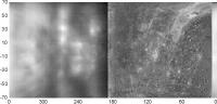
Radar And Mariner 10, Best possible mapping, pre-Messenger |

Radar And Mariner 10, Best possible mapping, pre-Messenger |
 Apr 28 2005, 06:21 PM Apr 28 2005, 06:21 PM
Post
#1
|
|
 Senior Member  Group: Members Posts: 2530 Joined: 20-April 05 Member No.: 321 |
[...]
|
 |
 
|
 |
|
Dec 8 2007, 12:13 PM
Post
#2
|
|
 Member Group: Members Posts: 106 Joined: 26-September 05 Member No.: 508 |
I am not sure if edstrick's post is an answer to my post but let me make it clear: Mariner 10 high res data covers 190 to 10 degrees longitude, not 190 to -10 as in gcecil's map. That map has a scale problem.
|
|
|
|
|
Dec 8 2007, 01:19 PM
Post
#3
|
||
|
Newbie Group: Members Posts: 16 Joined: 8-August 07 Member No.: 3138 |
QUOTE (Tayfun Öner @ Dec 8 2007, 07:13 AM)  I am not sure if edstrick's post is an answer to my post but let me make it clear: Mariner 10 high res data covers 190 to 10 degrees longitude, not 190 to -10 as in gcecil's map. That map has a scale problem. Yup, scale was messed up when I cutoff at +/-70 lat. Fixed now, so reposting with proper format. Thank you! This map
|
|
|
|
|
|
 JRehling Radar And Mariner 10 Apr 28 2005, 06:21 PM
 Decepticon http://www.lpl.arizona.edu/~rhill/alpo/mer...f/mes... May 11 2005, 12:20 AM Decepticon http://www.psrd.hawaii.edu/WebImg/HarmonRadarFig2.... May 11 2005, 12:25 AM
 lyford QUOTE (Decepticon @ May 10 2005, 04:25 PM)htt... May 11 2005, 01:48 AM
 JRehling [...] May 11 2005, 04:47 PM tedstryk (Added detail: One of the major methodologies in h... May 11 2005, 07:18 PM JRehling [...] May 11 2005, 09:34 PM Phil Stooke I too am interested in this topic of pre-Messenger... May 14 2005, 04:51 PM JRehling [...] May 16 2005, 12:04 AM Bob Shaw The mercury maps are astonishing at this stage in ... May 16 2005, 12:50 PM JRehling [...] May 16 2005, 08:45 PM Bob Shaw Thanks! May 16 2005, 09:11 PM Chmee These are great images obtained from the ground. ... May 17 2005, 04:43 PM lyford QUOTE (Chmee @ May 17 2005, 08:43 AM)These ar... May 17 2005, 04:53 PM JRehling [...] May 17 2005, 05:59 PM Bob Shaw A 'family portrait' of the Solar System by... May 17 2005, 07:45 PM djellison iirc - Hubble has a minimum sun angle which is can... May 17 2005, 04:54 PM Chmee I wonder if the concern is the actual damage if Hu... May 17 2005, 05:27 PM gndonald Erwin Van Der Velden's home page has moved. Hi... Aug 15 2005, 03:26 PM Bob Shaw QUOTE (gndonald @ Aug 15 2005, 04:26 PM)Erwin... Aug 15 2005, 07:08 PM OWW QUOTE (Bob Shaw @ Aug 15 2005, 07:08 PM)Wow... Nov 15 2005, 07:17 PM DonPMitchell Here's one of Ksanfomality's new photos of... May 8 2006, 05:56 AM PhilHorzempa I believe that 'Sky and Telescope' publish... May 20 2006, 05:04 AM tedstryk http://cps.earth.northwestern.edu/M10/TXT/encounte... May 20 2006, 04:40 PM PhilHorzempa QUOTE (tedstryk @ May 20 2006, 12:40 PM) ... May 23 2006, 03:00 AM DonPMitchell QUOTE (PhilHorzempa @ May 19 2006, 10:04 ... May 21 2006, 03:06 PM Malmer QUOTE (DonPMitchell @ May 21 2006, 05:06 ... May 21 2006, 08:38 PM DonPMitchell QUOTE (Malmer @ May 21 2006, 01:38 PM) Th... May 22 2006, 01:47 AM PhilHorzempa QUOTE (Malmer @ May 21 2006, 04:38 PM) Th... May 27 2006, 05:06 AM edstrick When Mariner 10 did it's second flyby, as it w... May 21 2006, 09:09 AM Bob Shaw QUOTE (edstrick @ May 21 2006, 10:09 AM) ... May 21 2006, 11:46 AM dvandorn You know, I got a book nearly 20 years ago that de... May 22 2006, 07:08 AM Bob Shaw oDoug:
Charles A Cross did an interesting mapping... May 22 2006, 01:54 PM edstrick Mariner 10 and Voyager had very similar camera sys... May 22 2006, 08:45 AM Phil Stooke Charles Cross did some interesting work. He let m... May 22 2006, 03:35 PM djellison I am a BAA member - give me some specifics and I... May 22 2006, 03:47 PM Phil Stooke I'm sorry, Doug, I don't know any more tha... May 22 2006, 05:07 PM DonPMitchell Do you have the ISIS calibration data for the Mari... May 23 2006, 04:00 AM antipode Outstanding new Arecibo radar images of equatorial... Dec 7 2006, 01:52 AM Phil Stooke Yes, that is an excellent article.
Phil Dec 7 2006, 02:57 AM dvandorn Too bad it would cost me $30USD to take a loo... Dec 7 2006, 04:49 AM tedstryk http://www.naic.edu/~radarusr/Mercury.pdf
You can... Dec 8 2006, 01:55 PM angel1801 I always wanted some good full disk coverage of Me... Dec 8 2006, 03:56 PM tedstryk That would be the first author, John Harmon. Dec 8 2006, 05:17 PM Phil Stooke This map is a composite of the USGS shaded relief ... Dec 9 2006, 05:58 PM Tayfun Öner While reading this thread I realized I made the cy... Dec 9 2006, 06:37 PM dvandorn Mucho, mucho gracias for the maps, Phil and Tayfun... Dec 9 2006, 08:10 PM Phil Stooke I have updated my composite map of Mercury, adding... Apr 8 2007, 06:18 PM JRehling [...] Apr 9 2007, 08:34 PM Phil Stooke ... and the southern hemisphere:
Phil Apr 8 2007, 06:19 PM volcanopele Using the above map, I ran through the first MESSE... Apr 8 2007, 07:34 PM ugordan Nice view VP. One thing I always wondered about vi... Apr 8 2007, 07:48 PM Phil Stooke That is really cool, VP, thanks.
ugordan, I thi... Apr 8 2007, 08:30 PM ugordan I see, Phil. I was under the impression that in 3D... Apr 8 2007, 08:39 PM Phil Stooke I don't mean you! But I encounter so many... Apr 9 2007, 03:16 AM lyford QUOTE (Phil Stooke @ Apr 8 2007, 08:16 PM... Apr 9 2007, 03:51 PM tedstryk All this is well and good, Phil, but let me ask yo... Apr 9 2007, 07:02 PM Phil Stooke Yes, Ted, I use them to make cootie-catchers... o... Apr 9 2007, 07:27 PM tfisher QUOTE (Phil Stooke @ Apr 9 2007, 03:27 PM... Apr 11 2007, 03:33 AM PhilHorzempa The significance of all of this effort to squeeze ... Apr 10 2007, 06:05 PM Phil Stooke I will go on record saying that I don't believ... Apr 10 2007, 06:09 PM JRehling [...] Apr 10 2007, 11:27 PM tedstryk QUOTE (Phil Stooke @ Apr 10 2007, 06:09 P... Apr 10 2007, 11:34 PM volcanopele Why do people see vague, dark, circular albedo mar... Apr 11 2007, 01:27 AM tedstryk So that, should they get lucky, they can claim the... Apr 11 2007, 09:52 AM Tayfun Öner As the first encounter is getting near, I plan to ... Dec 6 2007, 01:48 PM Phil Stooke Yes, this is a good idea. It will be interesting ... Dec 6 2007, 07:22 PM JRehling [...] Dec 6 2007, 07:34 PM nprev QUOTE (JRehling @ Dec 6 2007, 11:34 AM) W... Dec 6 2007, 08:21 PM 4th rock from the sun Hi,
Ok, here's the familiar Mercury map with ... Dec 6 2007, 09:01 PM Tayfun Öner Here it is. Some notes about the map: It was const... Dec 6 2007, 09:39 PM Tayfun Öner And here is version 2 with some fills. Dec 7 2007, 09:33 AM CAP-Team Here's a map of Mercury that I've been usi... Dec 7 2007, 05:58 PM gcecil QUOTE (CAP-Team @ Dec 7 2007, 12:58 ... Dec 8 2007, 02:11 AM ElkGroveDan Welcome Gerald. Thanks for the links to your pape... Dec 8 2007, 02:42 AM Tayfun Öner Hi gcecil, thanks for the map but it seems to have... Dec 8 2007, 10:17 AM edstrick Mariner 10 took a series of approach <crescent... Dec 8 2007, 11:46 AM Tayfun Öner Here is Version 3 with optical data added from Bau... Dec 8 2007, 02:35 PM edstrick I didn't spot the scale problem, I was just po... Dec 9 2007, 10:11 AM tedstryk Here is an example of a Mariner set that shows a b... Dec 14 2007, 03:56 AM peter59 I recognize that many of you are waiting for new i... Dec 30 2007, 09:13 AM tedstryk I have been playing around with some Mariner-10 sh... Jan 4 2008, 09:55 PM JRehling [...] Jan 4 2008, 10:41 PM tedstryk True-color is such a relative thing....I think eve... Jan 4 2008, 10:44 PM JRehling [...] Jan 4 2008, 10:57 PM tedstryk What I am trying to say is that it might take a wh... Jan 5 2008, 12:04 AM ugordan I personally think any color uncertainties in the ... Jan 5 2008, 12:42 AM tedstryk I think the lack of color is the problem. With co... Jan 5 2008, 01:20 AM JRehling [...] Jan 5 2008, 05:46 AM hendric QUOTE (tedstryk @ Jan 4 2008, 07:20 PM) O... Jan 6 2008, 04:19 AM nprev My brother is both color-blind (red-green, which a... Jan 6 2008, 05:35 AM peter59 Mariner 10 - First encounter with Mercury.
Image... Jan 7 2008, 07:03 PM tedstryk Here is a more distant approach view showing a lot... Jan 7 2008, 10:00 PM peter59 Mariner 10 - First encounter with Mercury (March 2... Jan 9 2008, 06:47 PM JRehling [...] Jan 9 2008, 06:52 PM tedstryk For the record, since the Mariner-10 outbound mosa... Jan 10 2008, 05:25 AM JRehling [...] Jan 10 2008, 06:55 PM edstrick I never understood why they didn't include tha... Jan 27 2008, 08:38 AM
JRehling [...] May 11 2005, 04:47 PM tedstryk (Added detail: One of the major methodologies in h... May 11 2005, 07:18 PM JRehling [...] May 11 2005, 09:34 PM Phil Stooke I too am interested in this topic of pre-Messenger... May 14 2005, 04:51 PM JRehling [...] May 16 2005, 12:04 AM Bob Shaw The mercury maps are astonishing at this stage in ... May 16 2005, 12:50 PM JRehling [...] May 16 2005, 08:45 PM Bob Shaw Thanks! May 16 2005, 09:11 PM Chmee These are great images obtained from the ground. ... May 17 2005, 04:43 PM lyford QUOTE (Chmee @ May 17 2005, 08:43 AM)These ar... May 17 2005, 04:53 PM JRehling [...] May 17 2005, 05:59 PM Bob Shaw A 'family portrait' of the Solar System by... May 17 2005, 07:45 PM djellison iirc - Hubble has a minimum sun angle which is can... May 17 2005, 04:54 PM Chmee I wonder if the concern is the actual damage if Hu... May 17 2005, 05:27 PM gndonald Erwin Van Der Velden's home page has moved. Hi... Aug 15 2005, 03:26 PM Bob Shaw QUOTE (gndonald @ Aug 15 2005, 04:26 PM)Erwin... Aug 15 2005, 07:08 PM OWW QUOTE (Bob Shaw @ Aug 15 2005, 07:08 PM)Wow... Nov 15 2005, 07:17 PM DonPMitchell Here's one of Ksanfomality's new photos of... May 8 2006, 05:56 AM PhilHorzempa I believe that 'Sky and Telescope' publish... May 20 2006, 05:04 AM tedstryk http://cps.earth.northwestern.edu/M10/TXT/encounte... May 20 2006, 04:40 PM PhilHorzempa QUOTE (tedstryk @ May 20 2006, 12:40 PM) ... May 23 2006, 03:00 AM DonPMitchell QUOTE (PhilHorzempa @ May 19 2006, 10:04 ... May 21 2006, 03:06 PM Malmer QUOTE (DonPMitchell @ May 21 2006, 05:06 ... May 21 2006, 08:38 PM DonPMitchell QUOTE (Malmer @ May 21 2006, 01:38 PM) Th... May 22 2006, 01:47 AM PhilHorzempa QUOTE (Malmer @ May 21 2006, 04:38 PM) Th... May 27 2006, 05:06 AM edstrick When Mariner 10 did it's second flyby, as it w... May 21 2006, 09:09 AM Bob Shaw QUOTE (edstrick @ May 21 2006, 10:09 AM) ... May 21 2006, 11:46 AM dvandorn You know, I got a book nearly 20 years ago that de... May 22 2006, 07:08 AM Bob Shaw oDoug:
Charles A Cross did an interesting mapping... May 22 2006, 01:54 PM edstrick Mariner 10 and Voyager had very similar camera sys... May 22 2006, 08:45 AM Phil Stooke Charles Cross did some interesting work. He let m... May 22 2006, 03:35 PM djellison I am a BAA member - give me some specifics and I... May 22 2006, 03:47 PM Phil Stooke I'm sorry, Doug, I don't know any more tha... May 22 2006, 05:07 PM DonPMitchell Do you have the ISIS calibration data for the Mari... May 23 2006, 04:00 AM antipode Outstanding new Arecibo radar images of equatorial... Dec 7 2006, 01:52 AM Phil Stooke Yes, that is an excellent article.
Phil Dec 7 2006, 02:57 AM dvandorn Too bad it would cost me $30USD to take a loo... Dec 7 2006, 04:49 AM tedstryk http://www.naic.edu/~radarusr/Mercury.pdf
You can... Dec 8 2006, 01:55 PM angel1801 I always wanted some good full disk coverage of Me... Dec 8 2006, 03:56 PM tedstryk That would be the first author, John Harmon. Dec 8 2006, 05:17 PM Phil Stooke This map is a composite of the USGS shaded relief ... Dec 9 2006, 05:58 PM Tayfun Öner While reading this thread I realized I made the cy... Dec 9 2006, 06:37 PM dvandorn Mucho, mucho gracias for the maps, Phil and Tayfun... Dec 9 2006, 08:10 PM Phil Stooke I have updated my composite map of Mercury, adding... Apr 8 2007, 06:18 PM JRehling [...] Apr 9 2007, 08:34 PM Phil Stooke ... and the southern hemisphere:
Phil Apr 8 2007, 06:19 PM volcanopele Using the above map, I ran through the first MESSE... Apr 8 2007, 07:34 PM ugordan Nice view VP. One thing I always wondered about vi... Apr 8 2007, 07:48 PM Phil Stooke That is really cool, VP, thanks.
ugordan, I thi... Apr 8 2007, 08:30 PM ugordan I see, Phil. I was under the impression that in 3D... Apr 8 2007, 08:39 PM Phil Stooke I don't mean you! But I encounter so many... Apr 9 2007, 03:16 AM lyford QUOTE (Phil Stooke @ Apr 8 2007, 08:16 PM... Apr 9 2007, 03:51 PM tedstryk All this is well and good, Phil, but let me ask yo... Apr 9 2007, 07:02 PM Phil Stooke Yes, Ted, I use them to make cootie-catchers... o... Apr 9 2007, 07:27 PM tfisher QUOTE (Phil Stooke @ Apr 9 2007, 03:27 PM... Apr 11 2007, 03:33 AM PhilHorzempa The significance of all of this effort to squeeze ... Apr 10 2007, 06:05 PM Phil Stooke I will go on record saying that I don't believ... Apr 10 2007, 06:09 PM JRehling [...] Apr 10 2007, 11:27 PM tedstryk QUOTE (Phil Stooke @ Apr 10 2007, 06:09 P... Apr 10 2007, 11:34 PM volcanopele Why do people see vague, dark, circular albedo mar... Apr 11 2007, 01:27 AM tedstryk So that, should they get lucky, they can claim the... Apr 11 2007, 09:52 AM Tayfun Öner As the first encounter is getting near, I plan to ... Dec 6 2007, 01:48 PM Phil Stooke Yes, this is a good idea. It will be interesting ... Dec 6 2007, 07:22 PM JRehling [...] Dec 6 2007, 07:34 PM nprev QUOTE (JRehling @ Dec 6 2007, 11:34 AM) W... Dec 6 2007, 08:21 PM 4th rock from the sun Hi,
Ok, here's the familiar Mercury map with ... Dec 6 2007, 09:01 PM Tayfun Öner Here it is. Some notes about the map: It was const... Dec 6 2007, 09:39 PM Tayfun Öner And here is version 2 with some fills. Dec 7 2007, 09:33 AM CAP-Team Here's a map of Mercury that I've been usi... Dec 7 2007, 05:58 PM gcecil QUOTE (CAP-Team @ Dec 7 2007, 12:58 ... Dec 8 2007, 02:11 AM ElkGroveDan Welcome Gerald. Thanks for the links to your pape... Dec 8 2007, 02:42 AM Tayfun Öner Hi gcecil, thanks for the map but it seems to have... Dec 8 2007, 10:17 AM edstrick Mariner 10 took a series of approach <crescent... Dec 8 2007, 11:46 AM Tayfun Öner Here is Version 3 with optical data added from Bau... Dec 8 2007, 02:35 PM edstrick I didn't spot the scale problem, I was just po... Dec 9 2007, 10:11 AM tedstryk Here is an example of a Mariner set that shows a b... Dec 14 2007, 03:56 AM peter59 I recognize that many of you are waiting for new i... Dec 30 2007, 09:13 AM tedstryk I have been playing around with some Mariner-10 sh... Jan 4 2008, 09:55 PM JRehling [...] Jan 4 2008, 10:41 PM tedstryk True-color is such a relative thing....I think eve... Jan 4 2008, 10:44 PM JRehling [...] Jan 4 2008, 10:57 PM tedstryk What I am trying to say is that it might take a wh... Jan 5 2008, 12:04 AM ugordan I personally think any color uncertainties in the ... Jan 5 2008, 12:42 AM tedstryk I think the lack of color is the problem. With co... Jan 5 2008, 01:20 AM JRehling [...] Jan 5 2008, 05:46 AM hendric QUOTE (tedstryk @ Jan 4 2008, 07:20 PM) O... Jan 6 2008, 04:19 AM nprev My brother is both color-blind (red-green, which a... Jan 6 2008, 05:35 AM peter59 Mariner 10 - First encounter with Mercury.
Image... Jan 7 2008, 07:03 PM tedstryk Here is a more distant approach view showing a lot... Jan 7 2008, 10:00 PM peter59 Mariner 10 - First encounter with Mercury (March 2... Jan 9 2008, 06:47 PM JRehling [...] Jan 9 2008, 06:52 PM tedstryk For the record, since the Mariner-10 outbound mosa... Jan 10 2008, 05:25 AM JRehling [...] Jan 10 2008, 06:55 PM edstrick I never understood why they didn't include tha... Jan 27 2008, 08:38 AM |

|
Lo-Fi Version | Time is now: 11th June 2024 - 04:02 AM |
|
RULES AND GUIDELINES Please read the Forum Rules and Guidelines before posting. IMAGE COPYRIGHT |
OPINIONS AND MODERATION Opinions expressed on UnmannedSpaceflight.com are those of the individual posters and do not necessarily reflect the opinions of UnmannedSpaceflight.com or The Planetary Society. The all-volunteer UnmannedSpaceflight.com moderation team is wholly independent of The Planetary Society. The Planetary Society has no influence over decisions made by the UnmannedSpaceflight.com moderators. |
SUPPORT THE FORUM Unmannedspaceflight.com is funded by the Planetary Society. Please consider supporting our work and many other projects by donating to the Society or becoming a member. |
|