Endeavour Crater, And again shall we conquer the Remoteness |

Endeavour Crater, And again shall we conquer the Remoteness |
 Sep 29 2008, 03:13 PM Sep 29 2008, 03:13 PM
Post
#1
|
||
 Special Cookie  Group: Members Posts: 2168 Joined: 6-April 05 From: Sintra | Portugal Member No.: 228 |
Opportunity is getting ready to embark on her most extraordinary journey, a true rover epic.
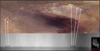
As information regarding how to win the distance are being collected here, and the emotional last views from Victoria Crater are being discussed here, I thought about creating a new thread that will surely become an obligatory stop as the tall peaks and other features of Endeavour start to rise in the horizon. Here we will be able to discuss the location of features seen from the distance, references that will help us understanding better what we are seing and that will, fortunately, feed our spirit across the long sail across the Meridiani sandwaves. Ultreya!  I give it a kick with this navcam image, comparing it with Astro0's original (beautiful...) image:
I'm sure James Canvin will correct me...  EDITED: I can't resist...I tried! I honestly tried, but it is stronger than me...so many features ahead and not a single name?!  Seriously, at Victoria we had features named after places visited by the vessel, and now for Endeavour? Assuming that Oppy will succeed on her quest will the mission keep the same policy, of naming places after Endeavour's tour? If so, there may be some names in common with Victoria...  While we are ready to leave the port once more I remembered that we could start naming, internally, (in order to have catchier landmark references... ) these features, as they loom in the horizon, after the ship's crew.We could follow the order presented here. Let me just edit the image up there...
-------------------- "Ride, boldly ride," The shade replied, "If you seek for Eldorado!"
Edgar Alan Poe |
|
 |
 
|
|
 |
|
Jun 1 2009, 11:27 PM
Post
#2
|
||
 Senior Member Group: Admin Posts: 4763 Joined: 15-March 05 From: Glendale, AZ Member No.: 197 |
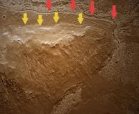
I'm also anticipating the outside chance that the exhuming began before or during the presence of the Meridiani Sea* and as the rover gains in elevation I'm hoping we will encounter distinct eroded shorelines. Would that be cool or what? I'm very intrigued by what we've seen in the HIRISE images and the apparent discontinuity at the base of the slopes.
(Yes I know it could just as easily be more ventifact topography.)
Attached thumbnail(s)
-------------------- If Occam had heard my theory, things would be very different now.
|
|
|
|
|
|
|
Jun 2 2009, 11:37 AM
Post
#3
|
|
 Senior Member Group: Moderator Posts: 2785 Joined: 10-November 06 From: Pasadena, CA Member No.: 1345 |
QUOTE (ElkGroveDan @ Jun 1 2009, 07:27 PM)  I'm very intrigued by what we've seen in the HIRISE images and the apparent discontinuity at the base of the slopes. (Yes I know it could just as easily be more ventifact topography.) What different observations from Opportunity would we expect to see if the "terrain break" resulted from: a shoreline? a ventrifact? from regolith creep? from ground ice movement (Are there key observations that could easily eliminate one or more of these?) [Time to put yer bets down, we'll be there before we know it!] -------------------- Some higher resolution images available at my photostream: http://www.flickr.com/photos/31678681@N07/
|
|
|
|
 ustrax Endeavour Crater Sep 29 2008, 03:13 PM
 fredk The latest press images include an orbital view wi... Mar 19 2009, 05:17 PM kenny It is surely a butte, illuminated from the west (l... Mar 23 2009, 09:55 AM imipak The shape reminds me of a nearby standing stone of... Mar 23 2009, 08:04 PM
 AndyG QUOTE (imipak @ Mar 23 2009, 08:04 PM) Ho... Mar 23 2009, 09:54 PM fredk To me the feature looks more like a partially buri... Mar 23 2009, 09:42 PM Bill Long, long time reader but first post.
Look at the... May 28 2009, 10:11 AM Oersted QUOTE (Bill @ May 28 2009, 12:11 PM) Long... May 28 2009, 06:06 PM fredk QUOTE (Bill @ May 28 2009, 11:11 AM) Look... May 31 2009, 12:01 AM Phil Stooke That's great - lots of new features coming int... May 28 2009, 10:27 AM mhoward That... is amazing. The left-camera view is good t... May 28 2009, 12:56 PM ustrax Wow!...
Here's a noisy, aligned horizon... May 28 2009, 01:22 PM Tesheiner My first impression was: "why would someone r... May 28 2009, 04:07 PM Hungry4info Are these faint distant hills the other side of th... May 28 2009, 06:00 PM BrianL Whoa, I'm starting to feel like we've fina... May 28 2009, 06:03 PM jamescanvin What we are seeing are more parts (almost the whol... May 28 2009, 06:23 PM Phil Stooke "Whoa, I'm starting to feel like we'v... May 28 2009, 06:45 PM ElkGroveDan We're 2/3 of the way from San Antonio to Fort ... May 28 2009, 07:28 PM Phil Stooke Here's my version. Six frames - two wide, thr... May 29 2009, 01:12 AM CosmicRocker Thanks for the contrast enhanced views, people. I... May 29 2009, 06:03 AM serpens QUOTE (CosmicRocker @ May 29 2009, 07:03 ... May 29 2009, 06:40 AM Ipparchus Can anyone give me a mineral map of the rim of End... May 29 2009, 11:26 AM PaulM QUOTE (Ipparchus @ May 29 2009, 12:26 PM)... Jun 1 2009, 07:09 PM Fran Ontanaya The CRISM maps are here:
http://crism-map.jhuapl.e... May 29 2009, 12:30 PM Ipparchus QUOTE (Fran Ontanaya @ May 29 2009, 02:30... May 30 2009, 03:51 PM Enceladus75 That is just fantastic. To finally see proper topo... May 30 2009, 03:25 AM fredk Once we turn towards the east we should see much m... May 30 2009, 04:17 AM jamescanvin Wait and then try again. It worked yesterday when ... May 30 2009, 04:26 PM Fran Ontanaya
This is one. I think red was olivine or iron phi... May 30 2009, 05:31 PM Floyd ustrax--how close are we to you track. I guess yo... May 31 2009, 11:58 PM jamescanvin QUOTE (Floyd @ Jun 1 2009, 12:58 AM) Jame... Jun 1 2009, 08:03 AM djellison QUOTE (jamescanvin @ Jun 1 2009, 09:03 AM... Jun 1 2009, 09:58 AM ustrax James making predictions and you writing "Onw... Jun 1 2009, 10:21 AM ustrax QUOTE (Floyd @ Jun 1 2009, 12:58 AM) ustr... Jun 1 2009, 08:21 AM Phil Stooke I would be turning on the big outcrop, driving sou... Jun 1 2009, 12:12 AM Floyd Thanks Phil, James & ustrax---I have a much cl... Jun 1 2009, 09:45 AM BrianL I'll go out on a limb here and say, not only w... Jun 1 2009, 05:45 PM Phil Stooke I don't think Endeavour's rim will consist... Jun 1 2009, 08:45 PM PaulM QUOTE (Phil Stooke @ Jun 1 2009, 09:45 PM... Jun 2 2009, 11:57 AM centsworth_II QUOTE (PaulM @ Jun 1 2009, 03:09 PM) I th... Jun 3 2009, 11:45 PM dburt Your "shorelines" could also be somethin... Jun 2 2009, 03:15 AM ElkGroveDan QUOTE (dburt @ Jun 1 2009, 08:15 PM) Your... Jun 2 2009, 04:54 AM centsworth_II QUOTE (ElkGroveDan @ Jun 2 2009, 12:54 AM... Jun 2 2009, 05:26 AM CosmicRocker QUOTE (Phil Stooke @ Jun 1 2009, 02:45 PM... Jun 2 2009, 04:27 AM djellison He's highlighting the fact that DB failed to a... Jun 2 2009, 07:27 AM centsworth_II QUOTE (djellison @ Jun 2 2009, 02:27 AM) ... Jun 2 2009, 07:54 AM ElkGroveDan QUOTE (centsworth_II @ Jun 2 2009, 12:54 ... Jun 2 2009, 02:27 PM djellison I think you are reading too much into throw away c... Jun 2 2009, 08:05 AM Phil Stooke One big problem with the Meridiani Sea is that the... Jun 2 2009, 04:14 PM glennwsmith I'm with Elk Grove Dan. Nobody, and that incl... Jun 2 2009, 06:16 PM imipak Further research is indicated. And as luck would h... Jun 2 2009, 07:12 PM JayB "The objective for June remains the same: ... Jun 2 2009, 07:26 PM MarkG In trying to understand Meridiani and the Endeavor... Jun 2 2009, 08:10 PM ngunn QUOTE (Phil Stooke @ Jun 2 2009, 05:14 PM... Jun 2 2009, 08:35 PM Phil Stooke Ngunn's point is really good - and I don't... Jun 2 2009, 08:47 PM MahFL QUOTE (Phil Stooke @ Jun 2 2009, 08:47 PM... Jun 3 2009, 01:18 PM tty QUOTE (MahFL @ Jun 3 2009, 03:18 PM) We h... Jun 3 2009, 08:24 PM Phil Stooke "there were alligators on Ellesmere Island... Jun 3 2009, 09:06 PM ElkGroveDan My fault for bringing the term "sea" int... Jun 3 2009, 11:22 PM serpens If we accept that the hematite signature is indica... Jun 4 2009, 06:38 AM CosmicRocker QUOTE (centsworth_II @ Jun 3 2009, 05:45 ... Jun 5 2009, 05:02 AM AndyG QUOTE (CosmicRocker @ Jun 5 2009, 06:02 A... Jun 5 2009, 08:05 AM fredk QUOTE (AndyG @ Jun 5 2009, 09:05 AM) How ... Jun 6 2009, 04:05 PM helvick If the far rim is 33.5 km distant and that is what... Jun 6 2009, 04:53 PM tim53 A Meridiani Sea is only possible if:
a: One invo... Jun 5 2009, 02:18 PM ElkGroveDan QUOTE (tim53 @ Jun 5 2009, 07:18 AM) The ... Jun 5 2009, 04:21 PM tim53 QUOTE (ElkGroveDan @ Jun 5 2009, 08:21 AM... Jun 5 2009, 04:30 PM tty QUOTE (tim53 @ Jun 5 2009, 04:18 PM) The ... Jun 6 2009, 06:34 PM stevesliva QUOTE (tty @ Jun 6 2009, 02:34 PM) In a m... Jun 6 2009, 06:45 PM CosmicRocker QUOTE (AndyG @ Jun 5 2009, 03:05 AM) ... ... Jun 6 2009, 06:30 AM Fran Ontanaya The HRSCview map of Endeavour was posted around he... Jun 6 2009, 01:28 PM Enceladus75 I thought a few months ago people here were giving... Jun 6 2009, 06:37 PM ElkGroveDan Here's an image of Antelope Island with wave c... Jun 6 2009, 07:12 PM tty QUOTE (ElkGroveDan @ Jun 6 2009, 09:12 PM... Jun 8 2009, 07:44 PM glennwsmith ElkGroveDan, that's a very neat picture -- it ... Jun 6 2009, 07:37 PM glennwsmith And tim53, re your "ocean in the northern pla... Jun 6 2009, 08:44 PM CosmicRocker I'm curious about the sample spacing in the MO... Jun 7 2009, 06:59 AM dvandorn The numbers you mention just describe the "re... Jun 7 2009, 02:18 PM helvick As Doug said it's hard to make any sort of gen... Jun 7 2009, 04:03 PM CosmicRocker Thanks guys, for your comments. I see how the act... Jun 8 2009, 04:13 AM Reed Regarding DTMs, don't forget there's Mars ... Jun 8 2009, 09:18 PM SFJCody This may have been asked before, but does anyone k... Jun 22 2009, 08:54 PM glennwsmith Speaking of shorelines, I'm sure most of you k... Jun 23 2009, 02:32 AM tim53 QUOTE (glennwsmith @ Jun 22 2009, 06:32 P... Jun 23 2009, 10:10 PM SFJCody For fans of Iazu crater here's a Google Earth ... Jun 27 2009, 09:27 PM Bill I think we can barely see a new part of Endeavour ... Jun 28 2009, 08:19 AM RoverDriver QUOTE (Bill @ Jun 28 2009, 12:19 AM) I th... Jun 28 2009, 01:39 PM Tesheiner QUOTE (RoverDriver @ Jun 28 2009, 03:39 P... Jun 28 2009, 09:21 PM jamescanvin QUOTE (Bill @ Jun 28 2009, 09:19 AM) I th... Jun 28 2009, 02:53 PM ustrax QUOTE (jamescanvin @ Jun 28 2009, 03:53 P... Jun 30 2009, 11:21 AM jamescanvin QUOTE (ustrax @ Jun 30 2009, 12:21 PM) Ja... Jun 30 2009, 12:17 PM ustrax QUOTE (jamescanvin @ Jun 30 2009, 01:17 P... Jun 30 2009, 01:04 PM fredk I've been collecting these L0 navcam frames an... Jun 29 2009, 02:33 AM RoverDriver QUOTE (fredk @ Jun 28 2009, 06:33 PM) ...... Jun 29 2009, 03:03 AM MahFL A very good idea Paolo. At what horizontal distanc... Jun 29 2009, 02:06 PM
AndyG QUOTE (imipak @ Mar 23 2009, 08:04 PM) Ho... Mar 23 2009, 09:54 PM fredk To me the feature looks more like a partially buri... Mar 23 2009, 09:42 PM Bill Long, long time reader but first post.
Look at the... May 28 2009, 10:11 AM Oersted QUOTE (Bill @ May 28 2009, 12:11 PM) Long... May 28 2009, 06:06 PM fredk QUOTE (Bill @ May 28 2009, 11:11 AM) Look... May 31 2009, 12:01 AM Phil Stooke That's great - lots of new features coming int... May 28 2009, 10:27 AM mhoward That... is amazing. The left-camera view is good t... May 28 2009, 12:56 PM ustrax Wow!...
Here's a noisy, aligned horizon... May 28 2009, 01:22 PM Tesheiner My first impression was: "why would someone r... May 28 2009, 04:07 PM Hungry4info Are these faint distant hills the other side of th... May 28 2009, 06:00 PM BrianL Whoa, I'm starting to feel like we've fina... May 28 2009, 06:03 PM jamescanvin What we are seeing are more parts (almost the whol... May 28 2009, 06:23 PM Phil Stooke "Whoa, I'm starting to feel like we'v... May 28 2009, 06:45 PM ElkGroveDan We're 2/3 of the way from San Antonio to Fort ... May 28 2009, 07:28 PM Phil Stooke Here's my version. Six frames - two wide, thr... May 29 2009, 01:12 AM CosmicRocker Thanks for the contrast enhanced views, people. I... May 29 2009, 06:03 AM serpens QUOTE (CosmicRocker @ May 29 2009, 07:03 ... May 29 2009, 06:40 AM Ipparchus Can anyone give me a mineral map of the rim of End... May 29 2009, 11:26 AM PaulM QUOTE (Ipparchus @ May 29 2009, 12:26 PM)... Jun 1 2009, 07:09 PM Fran Ontanaya The CRISM maps are here:
http://crism-map.jhuapl.e... May 29 2009, 12:30 PM Ipparchus QUOTE (Fran Ontanaya @ May 29 2009, 02:30... May 30 2009, 03:51 PM Enceladus75 That is just fantastic. To finally see proper topo... May 30 2009, 03:25 AM fredk Once we turn towards the east we should see much m... May 30 2009, 04:17 AM jamescanvin Wait and then try again. It worked yesterday when ... May 30 2009, 04:26 PM Fran Ontanaya
This is one. I think red was olivine or iron phi... May 30 2009, 05:31 PM Floyd ustrax--how close are we to you track. I guess yo... May 31 2009, 11:58 PM jamescanvin QUOTE (Floyd @ Jun 1 2009, 12:58 AM) Jame... Jun 1 2009, 08:03 AM djellison QUOTE (jamescanvin @ Jun 1 2009, 09:03 AM... Jun 1 2009, 09:58 AM ustrax James making predictions and you writing "Onw... Jun 1 2009, 10:21 AM ustrax QUOTE (Floyd @ Jun 1 2009, 12:58 AM) ustr... Jun 1 2009, 08:21 AM Phil Stooke I would be turning on the big outcrop, driving sou... Jun 1 2009, 12:12 AM Floyd Thanks Phil, James & ustrax---I have a much cl... Jun 1 2009, 09:45 AM BrianL I'll go out on a limb here and say, not only w... Jun 1 2009, 05:45 PM Phil Stooke I don't think Endeavour's rim will consist... Jun 1 2009, 08:45 PM PaulM QUOTE (Phil Stooke @ Jun 1 2009, 09:45 PM... Jun 2 2009, 11:57 AM centsworth_II QUOTE (PaulM @ Jun 1 2009, 03:09 PM) I th... Jun 3 2009, 11:45 PM dburt Your "shorelines" could also be somethin... Jun 2 2009, 03:15 AM ElkGroveDan QUOTE (dburt @ Jun 1 2009, 08:15 PM) Your... Jun 2 2009, 04:54 AM centsworth_II QUOTE (ElkGroveDan @ Jun 2 2009, 12:54 AM... Jun 2 2009, 05:26 AM CosmicRocker QUOTE (Phil Stooke @ Jun 1 2009, 02:45 PM... Jun 2 2009, 04:27 AM djellison He's highlighting the fact that DB failed to a... Jun 2 2009, 07:27 AM centsworth_II QUOTE (djellison @ Jun 2 2009, 02:27 AM) ... Jun 2 2009, 07:54 AM ElkGroveDan QUOTE (centsworth_II @ Jun 2 2009, 12:54 ... Jun 2 2009, 02:27 PM djellison I think you are reading too much into throw away c... Jun 2 2009, 08:05 AM Phil Stooke One big problem with the Meridiani Sea is that the... Jun 2 2009, 04:14 PM glennwsmith I'm with Elk Grove Dan. Nobody, and that incl... Jun 2 2009, 06:16 PM imipak Further research is indicated. And as luck would h... Jun 2 2009, 07:12 PM JayB "The objective for June remains the same: ... Jun 2 2009, 07:26 PM MarkG In trying to understand Meridiani and the Endeavor... Jun 2 2009, 08:10 PM ngunn QUOTE (Phil Stooke @ Jun 2 2009, 05:14 PM... Jun 2 2009, 08:35 PM Phil Stooke Ngunn's point is really good - and I don't... Jun 2 2009, 08:47 PM MahFL QUOTE (Phil Stooke @ Jun 2 2009, 08:47 PM... Jun 3 2009, 01:18 PM tty QUOTE (MahFL @ Jun 3 2009, 03:18 PM) We h... Jun 3 2009, 08:24 PM Phil Stooke "there were alligators on Ellesmere Island... Jun 3 2009, 09:06 PM ElkGroveDan My fault for bringing the term "sea" int... Jun 3 2009, 11:22 PM serpens If we accept that the hematite signature is indica... Jun 4 2009, 06:38 AM CosmicRocker QUOTE (centsworth_II @ Jun 3 2009, 05:45 ... Jun 5 2009, 05:02 AM AndyG QUOTE (CosmicRocker @ Jun 5 2009, 06:02 A... Jun 5 2009, 08:05 AM fredk QUOTE (AndyG @ Jun 5 2009, 09:05 AM) How ... Jun 6 2009, 04:05 PM helvick If the far rim is 33.5 km distant and that is what... Jun 6 2009, 04:53 PM tim53 A Meridiani Sea is only possible if:
a: One invo... Jun 5 2009, 02:18 PM ElkGroveDan QUOTE (tim53 @ Jun 5 2009, 07:18 AM) The ... Jun 5 2009, 04:21 PM tim53 QUOTE (ElkGroveDan @ Jun 5 2009, 08:21 AM... Jun 5 2009, 04:30 PM tty QUOTE (tim53 @ Jun 5 2009, 04:18 PM) The ... Jun 6 2009, 06:34 PM stevesliva QUOTE (tty @ Jun 6 2009, 02:34 PM) In a m... Jun 6 2009, 06:45 PM CosmicRocker QUOTE (AndyG @ Jun 5 2009, 03:05 AM) ... ... Jun 6 2009, 06:30 AM Fran Ontanaya The HRSCview map of Endeavour was posted around he... Jun 6 2009, 01:28 PM Enceladus75 I thought a few months ago people here were giving... Jun 6 2009, 06:37 PM ElkGroveDan Here's an image of Antelope Island with wave c... Jun 6 2009, 07:12 PM tty QUOTE (ElkGroveDan @ Jun 6 2009, 09:12 PM... Jun 8 2009, 07:44 PM glennwsmith ElkGroveDan, that's a very neat picture -- it ... Jun 6 2009, 07:37 PM glennwsmith And tim53, re your "ocean in the northern pla... Jun 6 2009, 08:44 PM CosmicRocker I'm curious about the sample spacing in the MO... Jun 7 2009, 06:59 AM dvandorn The numbers you mention just describe the "re... Jun 7 2009, 02:18 PM helvick As Doug said it's hard to make any sort of gen... Jun 7 2009, 04:03 PM CosmicRocker Thanks guys, for your comments. I see how the act... Jun 8 2009, 04:13 AM Reed Regarding DTMs, don't forget there's Mars ... Jun 8 2009, 09:18 PM SFJCody This may have been asked before, but does anyone k... Jun 22 2009, 08:54 PM glennwsmith Speaking of shorelines, I'm sure most of you k... Jun 23 2009, 02:32 AM tim53 QUOTE (glennwsmith @ Jun 22 2009, 06:32 P... Jun 23 2009, 10:10 PM SFJCody For fans of Iazu crater here's a Google Earth ... Jun 27 2009, 09:27 PM Bill I think we can barely see a new part of Endeavour ... Jun 28 2009, 08:19 AM RoverDriver QUOTE (Bill @ Jun 28 2009, 12:19 AM) I th... Jun 28 2009, 01:39 PM Tesheiner QUOTE (RoverDriver @ Jun 28 2009, 03:39 P... Jun 28 2009, 09:21 PM jamescanvin QUOTE (Bill @ Jun 28 2009, 09:19 AM) I th... Jun 28 2009, 02:53 PM ustrax QUOTE (jamescanvin @ Jun 28 2009, 03:53 P... Jun 30 2009, 11:21 AM jamescanvin QUOTE (ustrax @ Jun 30 2009, 12:21 PM) Ja... Jun 30 2009, 12:17 PM ustrax QUOTE (jamescanvin @ Jun 30 2009, 01:17 P... Jun 30 2009, 01:04 PM fredk I've been collecting these L0 navcam frames an... Jun 29 2009, 02:33 AM RoverDriver QUOTE (fredk @ Jun 28 2009, 06:33 PM) ...... Jun 29 2009, 03:03 AM MahFL A very good idea Paolo. At what horizontal distanc... Jun 29 2009, 02:06 PM |

|
Lo-Fi Version | Time is now: 19th June 2024 - 11:52 PM |
|
RULES AND GUIDELINES Please read the Forum Rules and Guidelines before posting. IMAGE COPYRIGHT |
OPINIONS AND MODERATION Opinions expressed on UnmannedSpaceflight.com are those of the individual posters and do not necessarily reflect the opinions of UnmannedSpaceflight.com or The Planetary Society. The all-volunteer UnmannedSpaceflight.com moderation team is wholly independent of The Planetary Society. The Planetary Society has no influence over decisions made by the UnmannedSpaceflight.com moderators. |
SUPPORT THE FORUM Unmannedspaceflight.com is funded by the Planetary Society. Please consider supporting our work and many other projects by donating to the Society or becoming a member. |
|