Updated Titan Map |

Updated Titan Map |
 Sep 9 2006, 09:46 PM Sep 9 2006, 09:46 PM
Post
#1
|
|
 Senior Member  Group: Members Posts: 1887 Joined: 20-November 04 From: Iowa Member No.: 110 |
I'm looking for a recent map ot Titan. Steve Albers's page links to one done by Fridger Schrempp in April 2005. Cassini has done a dozen flybys since then. Does anyone know if an updated map has been released.
|
 |
 
|
 |
|
Mar 19 2012, 12:54 AM
Post
#2
|
||
|
Member Group: Members Posts: 700 Joined: 1-April 08 From: Minnesota ! Member No.: 4081 |
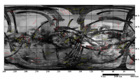
Thanks Machi for that very useful update of the Titan map! VP's maps are awesome but the overall map was not labeled and (at least in this blogsphere) are now more useful due to the white labels especially.
Below is your map (at reduced size and resolution) with a coordinate grid as many referenced photos and swaths are given by such coordinates.
|
|
|
|
|
|
|
Mar 23 2012, 05:06 PM
Post
#3
|
|||
 Senior Member Group: Members Posts: 2530 Joined: 20-April 05 Member No.: 321 |
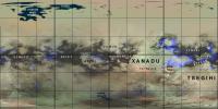
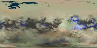
Here's my take on Titan, an effort I've wanted to pursue to get a map that is relatively seamless, relatively tied to scientific reality, and relatively complete. I shared this with a few people last fall.
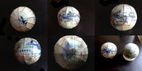
First, a huge component of what I have began with the maps that Fridger Schempp has posted at the following link. Everything I have produced is built on his contribution, which may well be 90% or 99% of the total work that produced my map. http://forum.celestialmatters.org/viewtopic.php?t=305 My work is based on, in essence, a black-and-white map, which is Fridger's with a few added areas of focus, particularly the northern lakes and seas as seen by RADAR (fused in with IR imagery of southern Kraken), plus some IR coverage here: http://photojournal.jpl.nasa.gov/catalog/PIA14908 The most original portion of my work is in adding a color overlay. Color information for Titan comes from VIMS, and the coverage is highly variable depending upon incidence angles. This produces some ugly seams that I wanted to eliminate at the hazard of throwing out the scientific and accurate information (which is not well captured in those seams, anyway). My approach in producing the color map was to combine two sources: First, global VIMS maps as seen here in the second map, using channels: B=1.27 μm, G=2.0 μm, R=4.8-5.2 μm. http://europlanet.dlr.de/node/index.php?id=482 I also used VIMS details from the (very exciting) paper here: http://barnesos.net/publications/papers/20...s.Evaporite.pdf The second color source (and the bridge used to connect those areas where VIMS coverage is poor) was the thematic mapping of equatorial areas in the particularly inspiring in Figure 19.19 Chapter 19 of "Titan From Cassini Huygens". My overall approach was to extend the thematic mapping (which had a VIMS-inspired palette for the bright/blue/brown regions) to the higher latitudes, without providing much detail besides the categorical existence of the lakes and seas, and the VIMS-orange areas such as Tui, Hotei, and as seen in the evaporite paper. I blended the thematic map and the VIMS products with no principle other than aesthetics, trying to keep the VIMS details whenever possible without creating ugly (and implausible) seams. It is exciting for me to contemplate the mapping of chemical composition to color; the five basic colors of my map are: Blue: VIMS-blue areas, like the methane-wet sands where Huygens touched down. (Dark blue except in eastern Xanadu, where the blue signal covers bright terrain.) Dark Brown: VIMS-brown areas, the sand dunes in equatorial regions. Orange: HC3N deposits that are evaporites, left also in cryovolcanic regions. Dark aqua: The methane/ethane lakes and seas. "Bright": rendered yellowish in Stephan, et al, but varying in hue in VIMS products, notably more greenish in Xanadu where the 2.0 μm signal is stronger; coincidentally, radar volume scattering is stronger there too, which made me consider greenish overlays to distinguish how volume scattering looks to me in ice. The ambiguity of the composition of this bright terrain fed a major obsession in my reading the past few months; an intriguing story that has left us so far uncertain what is covering the largest portions of Titan. I've attached a labeled version of the map. This has been repackaged a lot of ways: Unlabeled, a petal map, and a globe. I can upload the unlabeled and petal maps later if people are interested. I also attached some pictures of the resulting globe, and a side-by-side of the Titan globe with the Europa globe I made with the USGS map. There is some work that can be done, especially in waiting for more coverage of the northern areas, and more VIMS coverage to add resolution in the color, where I airbrushed it into a pleasing but not always accurate seamlessness. But I can say that I have a Titan globe beautifying my home.
Attached thumbnail(s)
|
||
|
|
|
||
|
Mar 27 2012, 03:39 PM
Post
#4
|
||
|
Senior Member Group: Members Posts: 2530 Joined: 20-April 05 Member No.: 321 |
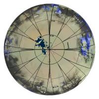
The file sizes are quite large. I saved them as low-loss jpgs, and I'll post each separately. Here is the south polar petal plot.
Attached thumbnail(s)
|
|
|
|
|
|
|
Mar 27 2012, 03:40 PM
Post
#5
|
||
|
Senior Member Group: Members Posts: 2530 Joined: 20-April 05 Member No.: 321 |
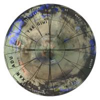
And here is the north polar petal plot. I left an azimuthal orthographic map as the background for the petals, so if you want a little "tab" to extend beyond the margins, you have something that looks about right. If you cut right on the lines, this won't matter.
I applied the labels and grid after reprojecting this, so you won't get such a nice result if you reproject the cylindrical map.
Attached thumbnail(s)
|
|
|
|
|
|
|
Mar 27 2012, 03:43 PM
Post
#6
|
||
|
Senior Member Group: Members Posts: 2530 Joined: 20-April 05 Member No.: 321 |
Finally, here is the cylindrical map without labels. I hope people find this useful for widespread use in Celestia, etc.
Attached thumbnail(s)
|
|
|
|
|
|
 alan Updated Titan Map Sep 9 2006, 09:46 PM
 Reckless This is my first post on a Titan thread.
The Bean... Jun 24 2007, 10:12 AM Ian R I'm not sure how useful this will be, but here... Jun 25 2007, 12:42 PM Juramike Dear Steve, Alan, and Phil,
Wow! That's ... Jun 25 2007, 02:41 PM ngunn mudflats? Jun 25 2007, 07:26 PM Juramike How about a "goo-flat"?
Methane rain br... Jun 25 2007, 07:53 PM
Reckless This is my first post on a Titan thread.
The Bean... Jun 24 2007, 10:12 AM Ian R I'm not sure how useful this will be, but here... Jun 25 2007, 12:42 PM Juramike Dear Steve, Alan, and Phil,
Wow! That's ... Jun 25 2007, 02:41 PM ngunn mudflats? Jun 25 2007, 07:26 PM Juramike How about a "goo-flat"?
Methane rain br... Jun 25 2007, 07:53 PM JRehling QUOTE (Juramike @ Jun 25 2007, 12:53 PM) ... Jun 25 2007, 08:30 PM
 rlorenz QUOTE (Juramike @ Jun 25 2007, 03:53 PM) ... Jun 26 2007, 02:39 PM Juramike Amazing! It does look pretty similar!
It... Jun 25 2007, 09:14 PM scalbers Greetings,
Thought I'd mention a slight clean... Jun 26 2007, 08:23 PM CAP-Team Steve, isn't your map aligned in a different w... Jun 26 2007, 08:47 PM scalbers Cap-Team - this is hard for me to say. This should... Jun 26 2007, 09:08 PM Juramike I created a graphic showing currently available no... Oct 11 2007, 05:00 PM Juramike The Planetary Photojournal has release a new ISS M... Oct 16 2007, 03:15 AM belleraphon1 Nice map. Mike.... thanks.
And we have your plot... Oct 16 2007, 12:54 PM Phil Stooke Juramike - post 115: go through LPI instead:
http... Oct 16 2007, 01:11 PM Phil Stooke This is the new radar map of the north pole added ... Oct 16 2007, 01:49 PM ugordan Great stuff, Phil!
I don't suppose there... Oct 16 2007, 01:54 PM Juramike Wow! Thanks, Phil!
That really fills in ... Oct 16 2007, 04:21 PM belleraphon1 Fantastic Phil....
Craig Oct 16 2007, 04:27 PM Olvegg Phil, it's really fantastic Thank you very mu... Oct 16 2007, 04:37 PM Juramike Hokay.... I tried to add the equatorial RADAR pie... Oct 16 2007, 05:16 PM David I'd love to see Phil's map in a proper Mer... Oct 16 2007, 05:58 PM volcanopele Here is the simple cylindrical map with reprojecte... Oct 16 2007, 10:29 PM Juramike Beautiful!
Thanks, VP!
-Mike Oct 16 2007, 10:38 PM elakdawalla You're the man, VP.
--Emily Oct 17 2007, 04:22 AM belleraphon1 Thanks VP!!!!
Is this release of ... Oct 17 2007, 01:11 PM Phil Stooke ... and another version. Here I've taken VP... Oct 17 2007, 06:01 PM ugordan Outstanding, thanks a lot Phil. That's a keepe... Oct 17 2007, 06:24 PM rlorenz QUOTE (Phil Stooke @ Oct 17 2007, 02:01 P... Oct 17 2007, 11:37 PM Phil Stooke "I notice on this map at the extreme left, ju... Oct 18 2007, 01:33 AM David QUOTE (Phil Stooke @ Oct 18 2007, 01:33 A... Oct 18 2007, 06:38 AM rlorenz QUOTE (David @ Oct 18 2007, 02:38 AM) Er.... Oct 18 2007, 05:00 PM David QUOTE (rlorenz @ Oct 18 2007, 05:00 PM) I... Oct 18 2007, 05:59 PM Juramike QUOTE (David @ Oct 18 2007, 01:59 PM) Wel... Oct 18 2007, 07:17 PM David QUOTE (Juramike @ Oct 18 2007, 07:17 PM) ... Oct 18 2007, 07:53 PM Phil Stooke Duh - sorry, Ralph. I thought you were making a j... Oct 18 2007, 07:24 PM volcanopele Ralph, those are artifacts. The original CB3 imag... Oct 18 2007, 11:46 PM rlorenz QUOTE (volcanopele @ Oct 18 2007, 07:46 P... Oct 19 2007, 04:07 PM volcanopele QUOTE (rlorenz @ Oct 19 2007, 09:07 AM) I... Oct 19 2007, 04:26 PM belleraphon1 VP...
Right now, you rule, man!!!... Oct 19 2007, 12:07 AM Juramike OK, I've [almost] given up.
Does anyone have ... Oct 19 2007, 02:31 PM Juramike Speaking of dark splots...the new mosaic shows a r... Oct 19 2007, 05:01 PM volcanopele That little spot is one of my favorite little area... Oct 19 2007, 06:20 PM Juramike The parabolic inky black shape of Omacatl and Elpi... Oct 19 2007, 06:54 PM volcanopele I doubt that. Winds can vary, but I doubt there w... Oct 19 2007, 07:14 PM Juramike Yup. T23 (Jan 13, 2007) RADAR Swath.
I'm hop... Oct 20 2007, 01:15 AM alan Some new images of Titan were taken on October 22.... Oct 27 2007, 06:19 PM ugordan QUOTE (alan @ Oct 27 2007, 08:19 PM) Some... Oct 27 2007, 06:52 PM dilo Hey Gordan, what do you think of this further enha... Nov 18 2007, 09:56 PM Floyd Maping question. For locked moons, is 0 degrees o... Nov 18 2007, 02:52 PM JRehling QUOTE (Floyd @ Nov 18 2007, 06:52 AM) Map... Nov 18 2007, 05:41 PM scalbers Yes that is how I understand it with zero degrees ... Nov 18 2007, 04:45 PM Phil Stooke That is indeed the basic idea, but because of orbi... Nov 18 2007, 06:55 PM rlorenz QUOTE (Phil Stooke @ Nov 18 2007, 01:55 P... Nov 19 2007, 01:42 AM Floyd Thank you for the responses to my map question. F... Nov 18 2007, 10:58 PM dvandorn Here's a question that seems appropriate in th... Nov 19 2007, 06:23 AM Doc QUOTE (dvandorn @ Nov 19 2007, 09:23 AM) ... Jan 10 2008, 10:53 AM edstrick Planetary photojournal released a nice tif format ... Nov 20 2007, 09:56 AM alan Will the CICLOPS map page be updated this month?
h... Jan 10 2008, 01:13 AM DrShank on a related topic, does anyone have or knowlocati... Jan 11 2008, 03:16 AM Exploitcorporations I'm not sure where I stumbled across this a wh... Jan 11 2008, 12:59 PM ugordan QUOTE (Exploitcorporations @ Jan 11 2008, 01... Jan 11 2008, 01:32 PM Exploitcorporations Using VP's awesome new map, we can revisit PIA... Jan 11 2008, 01:07 PM Decepticon I just wanted to clarify if all radar swath for th... Jan 26 2008, 02:41 PM helvick Didn't want to create a new topic for this but... Mar 27 2008, 07:13 PM volcanopele I posted an answer to his question on his blog. H... Mar 27 2008, 08:12 PM scalbers Greetings,
Here is a version of Titan made using ... Jul 12 2008, 03:41 PM David QUOTE (scalbers @ Jul 12 2008, 04:41 PM) ... Jul 12 2008, 04:08 PM Juramike QUOTE (David @ Jul 12 2008, 11:08 AM) Is ... Jul 18 2008, 11:56 AM titanicrivers "Is it possible to pinpoint the Huygens landi... Jul 16 2008, 06:35 PM titanicrivers Zooming in a bit further on the landing site!
Jul 18 2008, 07:32 AM Juramike Whoo-hoo! New Global Titan map released today... Feb 27 2009, 12:12 PM scalbers Nice to see the additional coverage, though this s... Feb 28 2009, 04:35 PM tedstryk QUOTE (scalbers @ Feb 28 2009, 05:35 PM) ... Feb 28 2009, 06:04 PM nprev Okay, let's not cross any lines here... Feb 28 2009, 06:10 PM scalbers We are on the threshold of an unseemly post Feb 28 2009, 06:26 PM scalbers Greetings, here's the 2011 CICLOPS Titan map s... Mar 3 2012, 08:23 PM scalbers And here's volcanopele's 2011 radar map wi... Mar 3 2012, 08:42 PM Phil Stooke As for the seams... don't forget these are pre... Mar 3 2012, 11:30 PM tanjent I have to marvel at how much remains unknown about... Mar 4 2012, 06:56 AM machi One of the Jason's map (thanks!) with labe... Mar 15 2012, 07:07 PM ngunn QUOTE (JRehling @ Mar 23 2012, 05:06 PM) ... Mar 23 2012, 06:36 PM Floyd Fantastic, thank you! Mar 23 2012, 05:24 PM JohnVV there is the Perl script from
http://www.vendian.o... Mar 27 2012, 04:21 AM scalbers At the AGU conference this past week I saw a Titan... Dec 9 2012, 07:17 PM machi According to his personal page, Antoine Lucas inte... Dec 9 2012, 07:58 PM titanicrivers A small portion of the cool T59 SAR shows a possib... Apr 3 2013, 09:51 PM JohnVV a quick run through isis3's "dstripe... Apr 3 2013, 10:30 PM titanicrivers Much thanks JohnVV for above. Have used your imag... Apr 5 2013, 03:37 PM machi Preliminary global map of Titan. Version 0.2.0.
In... Jan 28 2016, 06:39 PM JRehling Beautiful work, Machi! It's a challenge to... Jan 28 2016, 07:37 PM Phil Stooke Yes! All your maps are really nice, and this ... Jan 28 2016, 07:51 PM
rlorenz QUOTE (Juramike @ Jun 25 2007, 03:53 PM) ... Jun 26 2007, 02:39 PM Juramike Amazing! It does look pretty similar!
It... Jun 25 2007, 09:14 PM scalbers Greetings,
Thought I'd mention a slight clean... Jun 26 2007, 08:23 PM CAP-Team Steve, isn't your map aligned in a different w... Jun 26 2007, 08:47 PM scalbers Cap-Team - this is hard for me to say. This should... Jun 26 2007, 09:08 PM Juramike I created a graphic showing currently available no... Oct 11 2007, 05:00 PM Juramike The Planetary Photojournal has release a new ISS M... Oct 16 2007, 03:15 AM belleraphon1 Nice map. Mike.... thanks.
And we have your plot... Oct 16 2007, 12:54 PM Phil Stooke Juramike - post 115: go through LPI instead:
http... Oct 16 2007, 01:11 PM Phil Stooke This is the new radar map of the north pole added ... Oct 16 2007, 01:49 PM ugordan Great stuff, Phil!
I don't suppose there... Oct 16 2007, 01:54 PM Juramike Wow! Thanks, Phil!
That really fills in ... Oct 16 2007, 04:21 PM belleraphon1 Fantastic Phil....
Craig Oct 16 2007, 04:27 PM Olvegg Phil, it's really fantastic Thank you very mu... Oct 16 2007, 04:37 PM Juramike Hokay.... I tried to add the equatorial RADAR pie... Oct 16 2007, 05:16 PM David I'd love to see Phil's map in a proper Mer... Oct 16 2007, 05:58 PM volcanopele Here is the simple cylindrical map with reprojecte... Oct 16 2007, 10:29 PM Juramike Beautiful!
Thanks, VP!
-Mike Oct 16 2007, 10:38 PM elakdawalla You're the man, VP.
--Emily Oct 17 2007, 04:22 AM belleraphon1 Thanks VP!!!!
Is this release of ... Oct 17 2007, 01:11 PM Phil Stooke ... and another version. Here I've taken VP... Oct 17 2007, 06:01 PM ugordan Outstanding, thanks a lot Phil. That's a keepe... Oct 17 2007, 06:24 PM rlorenz QUOTE (Phil Stooke @ Oct 17 2007, 02:01 P... Oct 17 2007, 11:37 PM Phil Stooke "I notice on this map at the extreme left, ju... Oct 18 2007, 01:33 AM David QUOTE (Phil Stooke @ Oct 18 2007, 01:33 A... Oct 18 2007, 06:38 AM rlorenz QUOTE (David @ Oct 18 2007, 02:38 AM) Er.... Oct 18 2007, 05:00 PM David QUOTE (rlorenz @ Oct 18 2007, 05:00 PM) I... Oct 18 2007, 05:59 PM Juramike QUOTE (David @ Oct 18 2007, 01:59 PM) Wel... Oct 18 2007, 07:17 PM David QUOTE (Juramike @ Oct 18 2007, 07:17 PM) ... Oct 18 2007, 07:53 PM Phil Stooke Duh - sorry, Ralph. I thought you were making a j... Oct 18 2007, 07:24 PM volcanopele Ralph, those are artifacts. The original CB3 imag... Oct 18 2007, 11:46 PM rlorenz QUOTE (volcanopele @ Oct 18 2007, 07:46 P... Oct 19 2007, 04:07 PM volcanopele QUOTE (rlorenz @ Oct 19 2007, 09:07 AM) I... Oct 19 2007, 04:26 PM belleraphon1 VP...
Right now, you rule, man!!!... Oct 19 2007, 12:07 AM Juramike OK, I've [almost] given up.
Does anyone have ... Oct 19 2007, 02:31 PM Juramike Speaking of dark splots...the new mosaic shows a r... Oct 19 2007, 05:01 PM volcanopele That little spot is one of my favorite little area... Oct 19 2007, 06:20 PM Juramike The parabolic inky black shape of Omacatl and Elpi... Oct 19 2007, 06:54 PM volcanopele I doubt that. Winds can vary, but I doubt there w... Oct 19 2007, 07:14 PM Juramike Yup. T23 (Jan 13, 2007) RADAR Swath.
I'm hop... Oct 20 2007, 01:15 AM alan Some new images of Titan were taken on October 22.... Oct 27 2007, 06:19 PM ugordan QUOTE (alan @ Oct 27 2007, 08:19 PM) Some... Oct 27 2007, 06:52 PM dilo Hey Gordan, what do you think of this further enha... Nov 18 2007, 09:56 PM Floyd Maping question. For locked moons, is 0 degrees o... Nov 18 2007, 02:52 PM JRehling QUOTE (Floyd @ Nov 18 2007, 06:52 AM) Map... Nov 18 2007, 05:41 PM scalbers Yes that is how I understand it with zero degrees ... Nov 18 2007, 04:45 PM Phil Stooke That is indeed the basic idea, but because of orbi... Nov 18 2007, 06:55 PM rlorenz QUOTE (Phil Stooke @ Nov 18 2007, 01:55 P... Nov 19 2007, 01:42 AM Floyd Thank you for the responses to my map question. F... Nov 18 2007, 10:58 PM dvandorn Here's a question that seems appropriate in th... Nov 19 2007, 06:23 AM Doc QUOTE (dvandorn @ Nov 19 2007, 09:23 AM) ... Jan 10 2008, 10:53 AM edstrick Planetary photojournal released a nice tif format ... Nov 20 2007, 09:56 AM alan Will the CICLOPS map page be updated this month?
h... Jan 10 2008, 01:13 AM DrShank on a related topic, does anyone have or knowlocati... Jan 11 2008, 03:16 AM Exploitcorporations I'm not sure where I stumbled across this a wh... Jan 11 2008, 12:59 PM ugordan QUOTE (Exploitcorporations @ Jan 11 2008, 01... Jan 11 2008, 01:32 PM Exploitcorporations Using VP's awesome new map, we can revisit PIA... Jan 11 2008, 01:07 PM Decepticon I just wanted to clarify if all radar swath for th... Jan 26 2008, 02:41 PM helvick Didn't want to create a new topic for this but... Mar 27 2008, 07:13 PM volcanopele I posted an answer to his question on his blog. H... Mar 27 2008, 08:12 PM scalbers Greetings,
Here is a version of Titan made using ... Jul 12 2008, 03:41 PM David QUOTE (scalbers @ Jul 12 2008, 04:41 PM) ... Jul 12 2008, 04:08 PM Juramike QUOTE (David @ Jul 12 2008, 11:08 AM) Is ... Jul 18 2008, 11:56 AM titanicrivers "Is it possible to pinpoint the Huygens landi... Jul 16 2008, 06:35 PM titanicrivers Zooming in a bit further on the landing site!
Jul 18 2008, 07:32 AM Juramike Whoo-hoo! New Global Titan map released today... Feb 27 2009, 12:12 PM scalbers Nice to see the additional coverage, though this s... Feb 28 2009, 04:35 PM tedstryk QUOTE (scalbers @ Feb 28 2009, 05:35 PM) ... Feb 28 2009, 06:04 PM nprev Okay, let's not cross any lines here... Feb 28 2009, 06:10 PM scalbers We are on the threshold of an unseemly post Feb 28 2009, 06:26 PM scalbers Greetings, here's the 2011 CICLOPS Titan map s... Mar 3 2012, 08:23 PM scalbers And here's volcanopele's 2011 radar map wi... Mar 3 2012, 08:42 PM Phil Stooke As for the seams... don't forget these are pre... Mar 3 2012, 11:30 PM tanjent I have to marvel at how much remains unknown about... Mar 4 2012, 06:56 AM machi One of the Jason's map (thanks!) with labe... Mar 15 2012, 07:07 PM ngunn QUOTE (JRehling @ Mar 23 2012, 05:06 PM) ... Mar 23 2012, 06:36 PM Floyd Fantastic, thank you! Mar 23 2012, 05:24 PM JohnVV there is the Perl script from
http://www.vendian.o... Mar 27 2012, 04:21 AM scalbers At the AGU conference this past week I saw a Titan... Dec 9 2012, 07:17 PM machi According to his personal page, Antoine Lucas inte... Dec 9 2012, 07:58 PM titanicrivers A small portion of the cool T59 SAR shows a possib... Apr 3 2013, 09:51 PM JohnVV a quick run through isis3's "dstripe... Apr 3 2013, 10:30 PM titanicrivers Much thanks JohnVV for above. Have used your imag... Apr 5 2013, 03:37 PM machi Preliminary global map of Titan. Version 0.2.0.
In... Jan 28 2016, 06:39 PM JRehling Beautiful work, Machi! It's a challenge to... Jan 28 2016, 07:37 PM Phil Stooke Yes! All your maps are really nice, and this ... Jan 28 2016, 07:51 PM |

|
Lo-Fi Version | Time is now: 2nd June 2024 - 07:04 AM |
|
RULES AND GUIDELINES Please read the Forum Rules and Guidelines before posting. IMAGE COPYRIGHT |
OPINIONS AND MODERATION Opinions expressed on UnmannedSpaceflight.com are those of the individual posters and do not necessarily reflect the opinions of UnmannedSpaceflight.com or The Planetary Society. The all-volunteer UnmannedSpaceflight.com moderation team is wholly independent of The Planetary Society. The Planetary Society has no influence over decisions made by the UnmannedSpaceflight.com moderators. |
SUPPORT THE FORUM Unmannedspaceflight.com is funded by the Planetary Society. Please consider supporting our work and many other projects by donating to the Society or becoming a member. |
|