Continuing into Glenelg, Leaving Rocknest behind, sols 102-166 (Nov 18 2012-Jan 23, 2013) |

Continuing into Glenelg, Leaving Rocknest behind, sols 102-166 (Nov 18 2012-Jan 23, 2013) |
 Nov 19 2012, 05:36 AM Nov 19 2012, 05:36 AM
Post
#1
|
|
 Senior Member  Group: Admin Posts: 3108 Joined: 21-December 05 From: Canberra, Australia Member No.: 615 |
|
 |
 
|
 |
|
Nov 21 2012, 05:18 PM
Post
#2
|
|
|
Solar System Cartographer Group: Members Posts: 10186 Joined: 5-April 05 From: Canada Member No.: 227 |
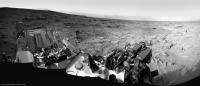
It's the big lump very prominent in HiRISE images, as shown in the route map:
http://www.unmannedspaceflight.com/index.p...st&id=28965 (upper left corner of that map). It has been seen very prominently in every panorama since landing, from west, south and east as we passed it. Phil -------------------- ... because the Solar System ain't gonna map itself.
Also to be found posting similar content on https://mastodon.social/@PhilStooke Maps for download (free PD: https://upload.wikimedia.org/wikipedia/comm...Cartography.pdf NOTE: everything created by me which I post on UMSF is considered to be in the public domain (NOT CC, public domain) |
|
|
|
 Astro0 Continuing into Glenelg Nov 19 2012, 05:36 AM
 EdTruthan Sol 102 - 1:17pm LMST - A few final shots at Rockn... Nov 19 2012, 09:13 AM Ant103 Ahh, it's good to see her on the road again ... Nov 19 2012, 12:14 PM akuo I didn't realise straight away that the sol 10... Nov 19 2012, 11:07 PM Phil Stooke Yes, it was.
http://astrogeology.usgs.gov/news/it... Nov 19 2012, 11:18 PM akuo I should remember to check the Astrogoelogy news s... Nov 19 2012, 11:41 PM Zelenyikot Maybe a little mistake with the sequence of action... Nov 20 2012, 07:44 AM remcook Love it! Nov 20 2012, 08:15 AM Ant103 Sol 102 Navcam pan updated with Sol 103 frames Nov 20 2012, 02:45 PM
EdTruthan Sol 102 - 1:17pm LMST - A few final shots at Rockn... Nov 19 2012, 09:13 AM Ant103 Ahh, it's good to see her on the road again ... Nov 19 2012, 12:14 PM akuo I didn't realise straight away that the sol 10... Nov 19 2012, 11:07 PM Phil Stooke Yes, it was.
http://astrogeology.usgs.gov/news/it... Nov 19 2012, 11:18 PM akuo I should remember to check the Astrogoelogy news s... Nov 19 2012, 11:41 PM Zelenyikot Maybe a little mistake with the sequence of action... Nov 20 2012, 07:44 AM remcook Love it! Nov 20 2012, 08:15 AM Ant103 Sol 102 Navcam pan updated with Sol 103 frames Nov 20 2012, 02:45 PM
 EdTruthan QUOTE (Ant103 @ Nov 20 2012, 06:45 AM) So... Nov 20 2012, 06:56 PM Phil Stooke ... and in circular format! (you would think ... Nov 20 2012, 03:02 PM Greenish Grotzinger indicates SAM soil results could be a b... Nov 20 2012, 04:01 PM xflare A quote from the article.
QUOTE Grotzinger says t... Nov 20 2012, 05:56 PM Phil Stooke http://photojournal.jpl.nasa.gov/catalog/PIA16447
... Nov 20 2012, 11:44 PM Astro0 ADMIN NOTE: TO ALL...
Following the interview by M... Nov 21 2012, 02:11 AM SFJCody I'm kind of looking forward to southern hemisp... Nov 21 2012, 02:27 AM ChrisC QUOTE (Astro0 @ Nov 20 2012, 10:11 PM) AD... Nov 21 2012, 02:51 AM Zelenyikot It is interesting to me as degree of a dust conten... Nov 21 2012, 02:47 AM stevelu background on the strictness of the rule here:
ht... Nov 21 2012, 04:20 AM fredk Remember too that one of the main points of the np... Nov 21 2012, 05:06 AM serpens Too true. Remember the hype over presidential bri... Nov 21 2012, 06:35 AM Cargo Cult Is this the right place for an interactive panoram... Nov 21 2012, 10:48 AM Tesheiner This is the thread, yes. Great job! Nov 21 2012, 11:28 AM Cargo Cult QUOTE (Tesheiner @ Nov 21 2012, 12:28 PM)... Nov 22 2012, 10:37 AM Stu Loving the latest images to come back from Curiosi... Nov 21 2012, 11:29 AM Ant103 Nearly full 360° anaglyph pan of Sols 102 & 10... Nov 21 2012, 12:39 PM RonJones As for the big announcement on Curiosity results, ... Nov 21 2012, 04:16 PM newdaddy06 Looking at the interactive pan ("NAVCAN Glene... Nov 21 2012, 04:18 PM elakdawalla If it's on the horizon, it is much bigger than... Nov 21 2012, 04:38 PM fredk Yeah, that's what we referred to as "Rock... Nov 21 2012, 05:59 PM stewjack QUOTE (fredk @ Nov 21 2012, 01:59 PM) Yea... Nov 21 2012, 08:49 PM ngunn I expect the horizon to close in dramatically as w... Nov 21 2012, 09:40 PM Phil Stooke It will not really be claustrophobia-inducing. A ... Nov 21 2012, 09:43 PM Zelenyikot After all dusty storm
http://www.jpl.nasa.gov/new... Nov 22 2012, 12:56 AM atomoid Rocky Point 'lump' sourcefiles in the SOL ... Nov 22 2012, 01:03 AM Zelenyikot Good! And why not to fill the sky with gray co... Nov 22 2012, 11:43 AM djellison Some people like to just process images as they ar... Nov 22 2012, 04:42 PM xflare These blue/grey rocks toward the top of the image ... Nov 25 2012, 09:53 AM stewjack QUOTE (xflare @ Nov 25 2012, 05:53 AM) Th... Nov 25 2012, 06:34 PM Cargo Cult I have no idea as to the geological origins, but n... Nov 25 2012, 10:42 AM Ant103 And my take on this mosaic. Yep, this is a great v... Nov 25 2012, 11:26 AM Zelenyikot What can it shine if not consequences from the EDL... Nov 25 2012, 12:37 PM Stu Oh, there's going to be EDL crud *everywhere*.... Nov 25 2012, 01:01 PM Zelenyikot However, it draws attention to itself. And if to l... Nov 25 2012, 01:13 PM climber On the above pans from Ant & Cargo, we can see... Nov 25 2012, 02:35 PM fredk QUOTE (climber @ Nov 25 2012, 03:35 PM) O... Nov 25 2012, 04:31 PM nprev To steal a phrase from Stu & the UK: Absolutel... Nov 25 2012, 02:51 PM ngunn QUOTE (nprev @ Nov 25 2012, 02:51 PM) Geo... Nov 25 2012, 04:34 PM EdTruthan Wowsers! Another complete HALF of the MC100 So... Nov 25 2012, 06:39 PM Phil Stooke My take on the geology - the alluvial fan north of... Nov 25 2012, 07:09 PM xflare QUOTE (Phil Stooke @ Nov 25 2012, 07:09 P... Nov 25 2012, 08:35 PM ngunn Phil that's exactly the overall picture I had ... Nov 25 2012, 08:03 PM Eyesonmars On the way to Glenelg we passed a couple of spots ... Nov 25 2012, 08:20 PM Ant103 Mastcam100 panoramic updated (see my previous post... Nov 25 2012, 09:11 PM Cargo Cult I really should have become a geologist. There... Nov 26 2012, 12:47 AM SFJCody I'm sort of reminded of the textures that Spir... Nov 26 2012, 03:36 AM Don1 I really like the idea of these rocks being layers... Nov 26 2012, 08:51 AM ngunn QUOTE (Don1 @ Nov 26 2012, 08:51 AM) I th... Nov 26 2012, 11:24 PM Don1 QUOTE (ngunn @ Nov 26 2012, 03:24 PM) The... Nov 27 2012, 05:14 AM brellis Thinking of Death Valley, one might wonder if ther... Nov 26 2012, 05:47 PM iMPREPREX I was a little impatient in waiting for image #55 ... Nov 26 2012, 10:24 PM elakdawalla According to the caption of a version of the Rockn... Nov 26 2012, 11:03 PM iMPREPREX Well, this Point Lake it awesome.
Do you know if... Nov 26 2012, 11:10 PM Julius I suppose that the Glenelg bedrock composition wou... Nov 26 2012, 11:32 PM elakdawalla Before you go off the deep end arm-waving about Ga... Nov 27 2012, 06:20 AM ngunn QUOTE (elakdawalla @ Nov 27 2012, 06:20 A... Nov 27 2012, 11:20 PM elakdawalla QUOTE (ngunn @ Nov 27 2012, 03:20 PM) Goo... Nov 28 2012, 12:50 AM Zelenyikot They are beautiful. I waited long ago this shot.
... Nov 27 2012, 11:56 AM Ant103 Wow, this is getting much BIGGER Some extra frame... Nov 27 2012, 05:44 PM vjkane I think Curiosity may be spending awhile there... Nov 27 2012, 07:58 PM rob66 So many features in that image to look at ! I ... Nov 27 2012, 08:00 PM pmetschan QUOTE (rob66 @ Nov 27 2012, 12:00 PM) So ... Nov 27 2012, 10:06 PM elakdawalla It is totally fine on this forum to describe thing... Nov 27 2012, 10:17 PM pmetschan QUOTE (elakdawalla @ Nov 27 2012, 02:17 P... Nov 27 2012, 10:29 PM ddan It's about here:
http://www.db-prods.net/ma... Nov 27 2012, 11:07 PM pmetschan Well trick of the light? I don't know, there d... Nov 27 2012, 11:19 PM fredk QUOTE (pmetschan @ Nov 28 2012, 12:19 AM)... Nov 28 2012, 12:35 AM Phil Stooke http://astrogeology.usgs.gov/news/item/sol...yello... Nov 27 2012, 10:24 PM serpens Yeah, looks like curiosity had turkey for thanksgi... Nov 27 2012, 11:26 PM iMPREPREX Hey folks. I Gigapanned my take on the Sol 107 and... Nov 27 2012, 11:31 PM machi These are fantastic mosaics! It was very good ... Nov 28 2012, 12:01 AM elakdawalla That strange rock caught my eye too. I think of it... Nov 28 2012, 12:38 AM iMPREPREX Thank you for the links to those papers! Nov 28 2012, 12:55 AM EdTruthan Under the front bumper - Sol 111... Nov 28 2012, 09:56 AM drz1111 One feature in that image that catches my eye is t... Nov 28 2012, 02:01 PM Phil Stooke You can see it an awful lot better in the Navcam a... Nov 28 2012, 02:37 PM drz1111 Interesting. But then why is the "depression... Nov 28 2012, 02:49 PM Phil Stooke Hopefully that is what Curiosity will tell us.
Ph... Nov 28 2012, 04:24 PM ngunn Just a reminder that there is a 'Geomorphology... Nov 29 2012, 07:12 PM Tesheiner QUOTE (ngunn @ Nov 29 2012, 08:12 PM) Jus... Nov 29 2012, 09:50 PM Ant103 Sol 111 Navcam pan after the small bump of Curiosi... Nov 30 2012, 12:21 AM stewjack This anaglyph strains my eyes a bit. I created it ... Nov 30 2012, 01:57 AM Phil Stooke A circular version of Ant103's half-pan.
Ph... Nov 30 2012, 02:46 AM jvandriel Sol 107-109 the complete Mastcam R Panoramic view.... Nov 30 2012, 01:03 PM fredk Stereo view of Phil's sea lions, from sol 109 ... Nov 30 2012, 04:17 PM Zelenyikot Very interesting formations. Thanks fredk. I ador... Nov 30 2012, 05:03 PM iMPREPREX The rest of the images came down for the Sol 107 a... Nov 30 2012, 07:10 PM EdTruthan Spot-free anaglyph of the extent to which the curr... Nov 30 2012, 08:24 PM
EdTruthan QUOTE (Ant103 @ Nov 20 2012, 06:45 AM) So... Nov 20 2012, 06:56 PM Phil Stooke ... and in circular format! (you would think ... Nov 20 2012, 03:02 PM Greenish Grotzinger indicates SAM soil results could be a b... Nov 20 2012, 04:01 PM xflare A quote from the article.
QUOTE Grotzinger says t... Nov 20 2012, 05:56 PM Phil Stooke http://photojournal.jpl.nasa.gov/catalog/PIA16447
... Nov 20 2012, 11:44 PM Astro0 ADMIN NOTE: TO ALL...
Following the interview by M... Nov 21 2012, 02:11 AM SFJCody I'm kind of looking forward to southern hemisp... Nov 21 2012, 02:27 AM ChrisC QUOTE (Astro0 @ Nov 20 2012, 10:11 PM) AD... Nov 21 2012, 02:51 AM Zelenyikot It is interesting to me as degree of a dust conten... Nov 21 2012, 02:47 AM stevelu background on the strictness of the rule here:
ht... Nov 21 2012, 04:20 AM fredk Remember too that one of the main points of the np... Nov 21 2012, 05:06 AM serpens Too true. Remember the hype over presidential bri... Nov 21 2012, 06:35 AM Cargo Cult Is this the right place for an interactive panoram... Nov 21 2012, 10:48 AM Tesheiner This is the thread, yes. Great job! Nov 21 2012, 11:28 AM Cargo Cult QUOTE (Tesheiner @ Nov 21 2012, 12:28 PM)... Nov 22 2012, 10:37 AM Stu Loving the latest images to come back from Curiosi... Nov 21 2012, 11:29 AM Ant103 Nearly full 360° anaglyph pan of Sols 102 & 10... Nov 21 2012, 12:39 PM RonJones As for the big announcement on Curiosity results, ... Nov 21 2012, 04:16 PM newdaddy06 Looking at the interactive pan ("NAVCAN Glene... Nov 21 2012, 04:18 PM elakdawalla If it's on the horizon, it is much bigger than... Nov 21 2012, 04:38 PM fredk Yeah, that's what we referred to as "Rock... Nov 21 2012, 05:59 PM stewjack QUOTE (fredk @ Nov 21 2012, 01:59 PM) Yea... Nov 21 2012, 08:49 PM ngunn I expect the horizon to close in dramatically as w... Nov 21 2012, 09:40 PM Phil Stooke It will not really be claustrophobia-inducing. A ... Nov 21 2012, 09:43 PM Zelenyikot After all dusty storm
http://www.jpl.nasa.gov/new... Nov 22 2012, 12:56 AM atomoid Rocky Point 'lump' sourcefiles in the SOL ... Nov 22 2012, 01:03 AM Zelenyikot Good! And why not to fill the sky with gray co... Nov 22 2012, 11:43 AM djellison Some people like to just process images as they ar... Nov 22 2012, 04:42 PM xflare These blue/grey rocks toward the top of the image ... Nov 25 2012, 09:53 AM stewjack QUOTE (xflare @ Nov 25 2012, 05:53 AM) Th... Nov 25 2012, 06:34 PM Cargo Cult I have no idea as to the geological origins, but n... Nov 25 2012, 10:42 AM Ant103 And my take on this mosaic. Yep, this is a great v... Nov 25 2012, 11:26 AM Zelenyikot What can it shine if not consequences from the EDL... Nov 25 2012, 12:37 PM Stu Oh, there's going to be EDL crud *everywhere*.... Nov 25 2012, 01:01 PM Zelenyikot However, it draws attention to itself. And if to l... Nov 25 2012, 01:13 PM climber On the above pans from Ant & Cargo, we can see... Nov 25 2012, 02:35 PM fredk QUOTE (climber @ Nov 25 2012, 03:35 PM) O... Nov 25 2012, 04:31 PM nprev To steal a phrase from Stu & the UK: Absolutel... Nov 25 2012, 02:51 PM ngunn QUOTE (nprev @ Nov 25 2012, 02:51 PM) Geo... Nov 25 2012, 04:34 PM EdTruthan Wowsers! Another complete HALF of the MC100 So... Nov 25 2012, 06:39 PM Phil Stooke My take on the geology - the alluvial fan north of... Nov 25 2012, 07:09 PM xflare QUOTE (Phil Stooke @ Nov 25 2012, 07:09 P... Nov 25 2012, 08:35 PM ngunn Phil that's exactly the overall picture I had ... Nov 25 2012, 08:03 PM Eyesonmars On the way to Glenelg we passed a couple of spots ... Nov 25 2012, 08:20 PM Ant103 Mastcam100 panoramic updated (see my previous post... Nov 25 2012, 09:11 PM Cargo Cult I really should have become a geologist. There... Nov 26 2012, 12:47 AM SFJCody I'm sort of reminded of the textures that Spir... Nov 26 2012, 03:36 AM Don1 I really like the idea of these rocks being layers... Nov 26 2012, 08:51 AM ngunn QUOTE (Don1 @ Nov 26 2012, 08:51 AM) I th... Nov 26 2012, 11:24 PM Don1 QUOTE (ngunn @ Nov 26 2012, 03:24 PM) The... Nov 27 2012, 05:14 AM brellis Thinking of Death Valley, one might wonder if ther... Nov 26 2012, 05:47 PM iMPREPREX I was a little impatient in waiting for image #55 ... Nov 26 2012, 10:24 PM elakdawalla According to the caption of a version of the Rockn... Nov 26 2012, 11:03 PM iMPREPREX Well, this Point Lake it awesome.
Do you know if... Nov 26 2012, 11:10 PM Julius I suppose that the Glenelg bedrock composition wou... Nov 26 2012, 11:32 PM elakdawalla Before you go off the deep end arm-waving about Ga... Nov 27 2012, 06:20 AM ngunn QUOTE (elakdawalla @ Nov 27 2012, 06:20 A... Nov 27 2012, 11:20 PM elakdawalla QUOTE (ngunn @ Nov 27 2012, 03:20 PM) Goo... Nov 28 2012, 12:50 AM Zelenyikot They are beautiful. I waited long ago this shot.
... Nov 27 2012, 11:56 AM Ant103 Wow, this is getting much BIGGER Some extra frame... Nov 27 2012, 05:44 PM vjkane I think Curiosity may be spending awhile there... Nov 27 2012, 07:58 PM rob66 So many features in that image to look at ! I ... Nov 27 2012, 08:00 PM pmetschan QUOTE (rob66 @ Nov 27 2012, 12:00 PM) So ... Nov 27 2012, 10:06 PM elakdawalla It is totally fine on this forum to describe thing... Nov 27 2012, 10:17 PM pmetschan QUOTE (elakdawalla @ Nov 27 2012, 02:17 P... Nov 27 2012, 10:29 PM ddan It's about here:
http://www.db-prods.net/ma... Nov 27 2012, 11:07 PM pmetschan Well trick of the light? I don't know, there d... Nov 27 2012, 11:19 PM fredk QUOTE (pmetschan @ Nov 28 2012, 12:19 AM)... Nov 28 2012, 12:35 AM Phil Stooke http://astrogeology.usgs.gov/news/item/sol...yello... Nov 27 2012, 10:24 PM serpens Yeah, looks like curiosity had turkey for thanksgi... Nov 27 2012, 11:26 PM iMPREPREX Hey folks. I Gigapanned my take on the Sol 107 and... Nov 27 2012, 11:31 PM machi These are fantastic mosaics! It was very good ... Nov 28 2012, 12:01 AM elakdawalla That strange rock caught my eye too. I think of it... Nov 28 2012, 12:38 AM iMPREPREX Thank you for the links to those papers! Nov 28 2012, 12:55 AM EdTruthan Under the front bumper - Sol 111... Nov 28 2012, 09:56 AM drz1111 One feature in that image that catches my eye is t... Nov 28 2012, 02:01 PM Phil Stooke You can see it an awful lot better in the Navcam a... Nov 28 2012, 02:37 PM drz1111 Interesting. But then why is the "depression... Nov 28 2012, 02:49 PM Phil Stooke Hopefully that is what Curiosity will tell us.
Ph... Nov 28 2012, 04:24 PM ngunn Just a reminder that there is a 'Geomorphology... Nov 29 2012, 07:12 PM Tesheiner QUOTE (ngunn @ Nov 29 2012, 08:12 PM) Jus... Nov 29 2012, 09:50 PM Ant103 Sol 111 Navcam pan after the small bump of Curiosi... Nov 30 2012, 12:21 AM stewjack This anaglyph strains my eyes a bit. I created it ... Nov 30 2012, 01:57 AM Phil Stooke A circular version of Ant103's half-pan.
Ph... Nov 30 2012, 02:46 AM jvandriel Sol 107-109 the complete Mastcam R Panoramic view.... Nov 30 2012, 01:03 PM fredk Stereo view of Phil's sea lions, from sol 109 ... Nov 30 2012, 04:17 PM Zelenyikot Very interesting formations. Thanks fredk. I ador... Nov 30 2012, 05:03 PM iMPREPREX The rest of the images came down for the Sol 107 a... Nov 30 2012, 07:10 PM EdTruthan Spot-free anaglyph of the extent to which the curr... Nov 30 2012, 08:24 PM |

|
Lo-Fi Version | Time is now: 6th June 2024 - 06:12 AM |
|
RULES AND GUIDELINES Please read the Forum Rules and Guidelines before posting. IMAGE COPYRIGHT |
OPINIONS AND MODERATION Opinions expressed on UnmannedSpaceflight.com are those of the individual posters and do not necessarily reflect the opinions of UnmannedSpaceflight.com or The Planetary Society. The all-volunteer UnmannedSpaceflight.com moderation team is wholly independent of The Planetary Society. The Planetary Society has no influence over decisions made by the UnmannedSpaceflight.com moderators. |
SUPPORT THE FORUM Unmannedspaceflight.com is funded by the Planetary Society. Please consider supporting our work and many other projects by donating to the Society or becoming a member. |
|


 Sol 102