Dawn data in the PDS |

Dawn data in the PDS |
 Feb 15 2012, 12:55 AM Feb 15 2012, 12:55 AM
Post
#1
|
|
 Administrator  Group: Admin Posts: 5172 Joined: 4-August 05 From: Pasadena, CA, USA, Earth Member No.: 454 |
Hey folks, Christmas came just a little bit late this year...
http://dawnpub.igpp.ucla.edu QUOTE DAWN DATA RELEASE: LEVEL 1A DATA FROM APPROACH AND SURVEY It is a LOT of data. Just the Vesta Approach includes about 2000 FC images! Wow!!!The Dawn project has created a public website that is available to serve the cruise and Vesta data sets that have been delivered to the Planetary Data System (PDS) while the data are still under review. Data are available from all three Dawn instruments, the Framing Camera (FC), the Visual and Infrared Mapping Spectrometer (VIR), and the Gamma Ray and Neutron Detector (GRaND). The data that are currently available are raw data, in engineering units, sometimes referred to as EDRs by the PDS or as NASA level-1a data. Additional data sets will be added when they are submitted to the PDS. The Dawn website is located at: http://dawnpub.igpp.ucla.edu Users of these data should exercise caution. Invariably there will be errors or omissions in the documentation. Please report any problems... I think that the first thing I'm going to work on is that approach sequence/movie that I wish I'd had in real time. The rotation of Vesta through the image sequences makes color composition very hard, but I am sure there are people here who are up to it. I hope someone here can come up with a pretty color global shot that I can put into a comparison montage! -------------------- My website - My Patreon - @elakdawalla on Twitter - Please support unmannedspaceflight.com by donating here.
|
 |
 
|
 |
|
Jul 22 2014, 04:30 PM
Post
#2
|
|||||
 IMG to PNG GOD Group: Moderator Posts: 2254 Joined: 19-February 04 From: Near fire and ice Member No.: 38 |
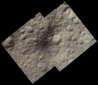
Here are two images showing Aricia Tholus:
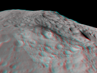
North is up. The first one is an approximately true color mosaic from HAMO data. The second one shows more details and includes LAMO images colorized from the HAMO images. The HAMO images were obtained by Dawn on October 26, 2011 and the LAMO images on April 30, 2012. Dawn imaged Vesta globally using all of its color filters during the HAMO mission phase. A lot of clear filter coverage was also acquired during LAMO but color coverage is limited. Only the 918, 749 and 548 nm filters were used for color during LAMO, the images are 2x2 binned and only cover selected parts of Vesta's surface. So if you want RGB LAMO images you must use HAMO images to colorize the LAMO clear filter images. As in the images I have posted earlier in this thread, the above mosaics were made by using the shape model to reproject the images to simple cylindrical projection. All of the mosaicking and color work was then done in simple cylindrical projection and the final image products then made by rendering the shape model with the map draped over it. The shape model is big and accurate enough that this works very well for HAMO and LAMO data. I sometimes needed to translate the reprojected data by 1-2 pixels in the x and/or y direction though when doing color composites and/or mosaics. Aricia Tholus is really a mountain but this is not obvious in the images above where we are looking directly down. But an anaglyph made by draping the above HAMO image on the hi-res shape model shows this beautifully; here we are looking to the west:
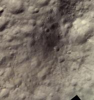
This also makes it obvious that even though some of Aricia Tholus is dark, parts of it are made darker by being tilted away from the sun. I should mention that I converted the shape model to a png file using the following img2png command: img2png global.pds -fstretch211946,293010 This results in a png file where black represents points that are 211.946 km from Vesta's center and white is 263.010 km from Vesta's center. This is the full elevation range of the shape model. The most recent version of img2png must be used for this to work properly. Of course it is also possible to use false color HAMO data to colorize the higher resolution LAMO data. Here is an example showing Aelia, a small crater with interesting streamer-like crater rays:
Here 918, 749 and 548 nm HAMO images are used for red, green and blue respectively. Color saturation has been greatly exaggerated, I set the saturation to 85 in Photoshop after first making the average color of the image gray. The HAMO images were obtained by Dawn on October 4, 2011 and the two LAMO images on January 10, 2012 and April 30, 2012. |
||||
|
|
|
||||
 elakdawalla Dawn data in the PDS Feb 15 2012, 12:55 AM
 elakdawalla I'm so excited about this data that I'm br... Feb 15 2012, 06:16 AM
 Stu QUOTE (elakdawalla @ Feb 15 2012, 06:16 A... Feb 15 2012, 11:19 AM elakdawalla (Sorry if I am talking to my self here. I hope it... Feb 15 2012, 06:38 AM Astro0 Awesome work Emily.
With the images and animation... Feb 15 2012, 10:22 AM machi I'm very happy with that data release, and you... Feb 15 2012, 12:03 PM Adam Hurcewicz now I see "This site is temporarily under con... Feb 15 2012, 07:00 PM elakdawalla QUOTE (Adam Hurcewicz @ Feb 15 2012, 11:0... Feb 15 2012, 10:04 PM PDP8E Emily, nice animation! Feb 15 2012, 08:01 PM Adam Hurcewicz So where is this data ? Anyone knows ? Feb 17 2012, 10:26 AM pablogm1024 Is it right to say that, if data has been publicly... Feb 17 2012, 02:50 PM Floyd I doubt that anyone in this forum would say no.
... Feb 17 2012, 04:18 PM Phil Stooke The original link went into the data page, now it ... Feb 17 2012, 04:53 PM Phil Stooke Just noticed this at the PDS Small Bodies Node:
h... Feb 19 2012, 01:54 AM antoniseb Including, that the Hayabasa imaging and v2 of the... Feb 21 2012, 02:58 PM machi Does anyone know, what happened to Dawn's FC r... Apr 3 2012, 05:45 PM Phil Stooke No, much more complicated. There is a disagreemen... Apr 3 2012, 06:17 PM machi Thanks for answering my question! Apr 3 2012, 06:37 PM elakdawalla I talked with several scientists at LPSC about thi... Apr 3 2012, 11:08 PM machi "When I can find time to work with it I'l... Apr 4 2012, 10:27 AM Sarunia According to http://pds-smallbodies.astro.umd.edu/... Apr 28 2012, 11:47 AM Phil Stooke May not be reliable. I don't think the underl... Apr 28 2012, 03:02 PM morganism LAMO data released for Grand
http://sbn.psi.edu/p... Sep 11 2012, 12:44 AM TheAnt Water on Vesta, that's a surprise.
Science da... Sep 21 2012, 09:39 PM ngunn I don't find it surprising. There's water ... Sep 21 2012, 10:08 PM Paolo the original papers in Science Express:
Elemental ... Sep 22 2012, 11:14 AM ngunn Freely available Supplementary Materials from the ... Sep 22 2012, 12:49 PM Paolo still more papers on Dawn at Vesta in today's ... Oct 31 2012, 07:35 PM machi And now for something completely different - Dawn ... Nov 15 2012, 01:20 AM Sarunia It's fantastic news Finally we have it ... Nov 15 2012, 12:49 PM elakdawalla Here's a page I built to browse the Vesta appr... Nov 16 2012, 05:01 AM elakdawalla Too tired to do anything very insightful with the ... Nov 16 2012, 06:55 AM tedstryk Oh for a little bit of panning about...sometimes I... Nov 16 2012, 03:12 PM elakdawalla I have not yet seen a *single* color global mosaic... Nov 16 2012, 05:16 PM Bjorn Jonsson QUOTE (elakdawalla @ Nov 16 2012, 05:16 P... Nov 17 2012, 12:22 AM Tom Tamlyn QUOTE (elakdawalla @ Nov 16 2012, 12:16 P... Nov 17 2012, 07:27 AM machi QUOTE (Sarunia @ Nov 15 2012, 01:49 PM) .... Nov 16 2012, 06:13 PM elakdawalla I would be very grateful if you could do that one ... Nov 16 2012, 06:32 PM machi I haven't that one in "true" colors,... Nov 16 2012, 06:57 PM Stefan QUOTE (machi @ Nov 16 2012, 07:57 PM) I h... Nov 18 2012, 07:45 PM elakdawalla Thank you! And here is another index page, to ... Nov 16 2012, 08:38 PM Bjorn Jonsson And now I suddenly remember that already more than... Nov 17 2012, 11:54 AM djellison You might want to take a look at this regarding sh... Nov 17 2012, 04:38 PM Bjorn Jonsson Two 8 month old posts from this thread:
QUOTE (dje... Jul 18 2013, 10:24 PM Sarunia QUOTE (Bjorn Jonsson @ Jul 19 2013, 12:24... Jul 22 2013, 10:38 AM Bjorn Jonsson QUOTE (Sarunia @ Jul 22 2013, 10:38 AM) V... Jul 24 2013, 11:50 PM Sarunia This shape is from Dr Robert Gaskell produced afte... Nov 17 2012, 05:11 PM Sarunia My quick attempt of projection to the shape model.... Nov 17 2012, 07:40 PM machi Thank you for that image! That will be useful ... Nov 19 2012, 03:55 PM Stefan QUOTE (machi @ Nov 19 2012, 04:55 PM) Tha... Nov 20 2012, 12:53 PM Explorer1 Just remember they're not to scale in Stefan... Nov 19 2012, 10:19 PM machi I think that albedo is in scale. Nov 19 2012, 10:52 PM Explorer1 The colors are fine, I know. I just mean the sizes... Nov 20 2012, 12:11 AM machi Mosaic of the south pole of Vesta and other images... Nov 24 2012, 12:07 AM Explorer1 Stunning work machi! That's what we were a... Nov 24 2012, 12:46 AM Ian R Merci Beaucoup! Nov 24 2012, 04:57 PM Phil Stooke Very nice mosaic - thanks!
Phil Nov 25 2012, 01:11 AM machi Thank you all!
I must say, that this dataset ... Nov 26 2012, 07:14 PM jasedm Wyborowy!! Nov 26 2012, 07:25 PM Hungry4info That's amazing! Are those images from HAMO... Nov 26 2012, 08:22 PM machi Yes, that's images from HAMO. I forgot that. I... Nov 26 2012, 08:33 PM Sarunia Machi, your mosaics of Rheasilva and Snowman crate... Nov 26 2012, 08:33 PM machi Není zač! Nov 26 2012, 08:50 PM Bjorn Jonsson Wow! These are awesome mosaics, especially the... Nov 27 2012, 01:52 PM Adam Hurcewicz Here is my version of RGB Vesta
Images are taken 2... Nov 28 2012, 12:02 PM stevesliva Press release regarding "sinuous" gullie... Dec 7 2012, 01:27 AM morganism New image browsing tool availible at PDS for Vesta... Dec 16 2012, 12:13 AM JohnVV glad something is working with the new format
i ... Jul 25 2013, 02:23 AM Bjorn Jonsson Yes, I knew about this example code but I haven... Jul 25 2013, 10:23 PM Paolo an extremely interesting paper comparing Dawn and ... Jul 27 2013, 09:09 AM Bjorn Jonsson Does anyone reading this know how accurate the rel... Aug 8 2013, 09:47 PM elakdawalla I've sent an email to a friend on the Dawn tea... Aug 8 2013, 10:00 PM Sarunia The shape from Gaskell seems to use the old prime ... Aug 8 2013, 11:58 PM Bjorn Jonsson QUOTE (Sarunia @ Aug 8 2013, 11:58 PM) Th... Aug 9 2013, 12:32 AM Bjorn Jonsson Everything works now. This is a test image where a... Aug 10 2013, 11:03 PM Sarunia QUOTE (Bjorn Jonsson @ Aug 11 2013, 01:03... Aug 12 2013, 10:27 AM JohnVV LSB vs. MSB
aren't 16 bit images fun Aug 11 2013, 08:19 AM Sarunia I tested with the new rate rotation and it doesn... Aug 12 2013, 09:20 PM Bjorn Jonsson I now have some results of my processing. They rec... Aug 23 2013, 11:33 PM peter59 HAMO2 and LAMO released about five hours ago.
htt... Aug 13 2013, 09:34 PM Bjorn Jonsson Here are two global mosaics from the survey phase ... Sep 18 2013, 11:19 PM tedstryk Simply stunning! These are the first large, c... Sep 19 2013, 02:55 PM Phil Stooke Beautiful, Bjorn - well done!
Phil Sep 19 2013, 12:25 AM Superstring Does anyone know when we can expect the first bett... Oct 20 2013, 09:18 PM elakdawalla It will be not long after they get the first pictu... Oct 20 2013, 09:28 PM Adam Hurcewicz Here is Dawn approach to Vesta from 305 images at ... Jan 8 2014, 02:55 PM Bjorn Jonsson Strictly speaking not PDS but it's comparable:... Jun 22 2014, 01:34 AM machi Beautiful images!
BTW, I missed completely you... Jul 22 2014, 06:56 PM Phil Stooke I missed that initial post too. Very interesting.... Jul 22 2014, 07:51 PM JohnVV from another post of mine on a different forum
bu... Jul 26 2014, 06:57 PM Bjorn Jonsson Time flies. It's as if Dawn was at Vesta yeste... Jan 5 2015, 11:32 PM elakdawalla Fantastic work, Bjorn.
FYI to all, the original p... Jan 5 2015, 11:45 PM Superstring Forgive me if this was inferred in your post, but ... Jan 6 2015, 01:00 AM elakdawalla Yes, there will be color images, for sure. At leas... Jan 6 2015, 05:48 AM JohnVV from the "HAMO_truecolor_DLR" folder
ht... Apr 20 2015, 01:56 AM JohnVV might be a down server ,but as of just now ( i not... Aug 28 2015, 07:22 AM volcanopele Ceres FC and VIR data from Approach and the RC3 or... Oct 20 2015, 03:15 PM ZLD Over 2GB for Approach and RC3, really? Wasn't ... Oct 20 2015, 06:07 PM ZLD Someone care to explain why the bright spots in Oc... Oct 20 2015, 06:20 PM
Stu QUOTE (elakdawalla @ Feb 15 2012, 06:16 A... Feb 15 2012, 11:19 AM elakdawalla (Sorry if I am talking to my self here. I hope it... Feb 15 2012, 06:38 AM Astro0 Awesome work Emily.
With the images and animation... Feb 15 2012, 10:22 AM machi I'm very happy with that data release, and you... Feb 15 2012, 12:03 PM Adam Hurcewicz now I see "This site is temporarily under con... Feb 15 2012, 07:00 PM elakdawalla QUOTE (Adam Hurcewicz @ Feb 15 2012, 11:0... Feb 15 2012, 10:04 PM PDP8E Emily, nice animation! Feb 15 2012, 08:01 PM Adam Hurcewicz So where is this data ? Anyone knows ? Feb 17 2012, 10:26 AM pablogm1024 Is it right to say that, if data has been publicly... Feb 17 2012, 02:50 PM Floyd I doubt that anyone in this forum would say no.
... Feb 17 2012, 04:18 PM Phil Stooke The original link went into the data page, now it ... Feb 17 2012, 04:53 PM Phil Stooke Just noticed this at the PDS Small Bodies Node:
h... Feb 19 2012, 01:54 AM antoniseb Including, that the Hayabasa imaging and v2 of the... Feb 21 2012, 02:58 PM machi Does anyone know, what happened to Dawn's FC r... Apr 3 2012, 05:45 PM Phil Stooke No, much more complicated. There is a disagreemen... Apr 3 2012, 06:17 PM machi Thanks for answering my question! Apr 3 2012, 06:37 PM elakdawalla I talked with several scientists at LPSC about thi... Apr 3 2012, 11:08 PM machi "When I can find time to work with it I'l... Apr 4 2012, 10:27 AM Sarunia According to http://pds-smallbodies.astro.umd.edu/... Apr 28 2012, 11:47 AM Phil Stooke May not be reliable. I don't think the underl... Apr 28 2012, 03:02 PM morganism LAMO data released for Grand
http://sbn.psi.edu/p... Sep 11 2012, 12:44 AM TheAnt Water on Vesta, that's a surprise.
Science da... Sep 21 2012, 09:39 PM ngunn I don't find it surprising. There's water ... Sep 21 2012, 10:08 PM Paolo the original papers in Science Express:
Elemental ... Sep 22 2012, 11:14 AM ngunn Freely available Supplementary Materials from the ... Sep 22 2012, 12:49 PM Paolo still more papers on Dawn at Vesta in today's ... Oct 31 2012, 07:35 PM machi And now for something completely different - Dawn ... Nov 15 2012, 01:20 AM Sarunia It's fantastic news Finally we have it ... Nov 15 2012, 12:49 PM elakdawalla Here's a page I built to browse the Vesta appr... Nov 16 2012, 05:01 AM elakdawalla Too tired to do anything very insightful with the ... Nov 16 2012, 06:55 AM tedstryk Oh for a little bit of panning about...sometimes I... Nov 16 2012, 03:12 PM elakdawalla I have not yet seen a *single* color global mosaic... Nov 16 2012, 05:16 PM Bjorn Jonsson QUOTE (elakdawalla @ Nov 16 2012, 05:16 P... Nov 17 2012, 12:22 AM Tom Tamlyn QUOTE (elakdawalla @ Nov 16 2012, 12:16 P... Nov 17 2012, 07:27 AM machi QUOTE (Sarunia @ Nov 15 2012, 01:49 PM) .... Nov 16 2012, 06:13 PM elakdawalla I would be very grateful if you could do that one ... Nov 16 2012, 06:32 PM machi I haven't that one in "true" colors,... Nov 16 2012, 06:57 PM Stefan QUOTE (machi @ Nov 16 2012, 07:57 PM) I h... Nov 18 2012, 07:45 PM elakdawalla Thank you! And here is another index page, to ... Nov 16 2012, 08:38 PM Bjorn Jonsson And now I suddenly remember that already more than... Nov 17 2012, 11:54 AM djellison You might want to take a look at this regarding sh... Nov 17 2012, 04:38 PM Bjorn Jonsson Two 8 month old posts from this thread:
QUOTE (dje... Jul 18 2013, 10:24 PM Sarunia QUOTE (Bjorn Jonsson @ Jul 19 2013, 12:24... Jul 22 2013, 10:38 AM Bjorn Jonsson QUOTE (Sarunia @ Jul 22 2013, 10:38 AM) V... Jul 24 2013, 11:50 PM Sarunia This shape is from Dr Robert Gaskell produced afte... Nov 17 2012, 05:11 PM Sarunia My quick attempt of projection to the shape model.... Nov 17 2012, 07:40 PM machi Thank you for that image! That will be useful ... Nov 19 2012, 03:55 PM Stefan QUOTE (machi @ Nov 19 2012, 04:55 PM) Tha... Nov 20 2012, 12:53 PM Explorer1 Just remember they're not to scale in Stefan... Nov 19 2012, 10:19 PM machi I think that albedo is in scale. Nov 19 2012, 10:52 PM Explorer1 The colors are fine, I know. I just mean the sizes... Nov 20 2012, 12:11 AM machi Mosaic of the south pole of Vesta and other images... Nov 24 2012, 12:07 AM Explorer1 Stunning work machi! That's what we were a... Nov 24 2012, 12:46 AM Ian R Merci Beaucoup! Nov 24 2012, 04:57 PM Phil Stooke Very nice mosaic - thanks!
Phil Nov 25 2012, 01:11 AM machi Thank you all!
I must say, that this dataset ... Nov 26 2012, 07:14 PM jasedm Wyborowy!! Nov 26 2012, 07:25 PM Hungry4info That's amazing! Are those images from HAMO... Nov 26 2012, 08:22 PM machi Yes, that's images from HAMO. I forgot that. I... Nov 26 2012, 08:33 PM Sarunia Machi, your mosaics of Rheasilva and Snowman crate... Nov 26 2012, 08:33 PM machi Není zač! Nov 26 2012, 08:50 PM Bjorn Jonsson Wow! These are awesome mosaics, especially the... Nov 27 2012, 01:52 PM Adam Hurcewicz Here is my version of RGB Vesta
Images are taken 2... Nov 28 2012, 12:02 PM stevesliva Press release regarding "sinuous" gullie... Dec 7 2012, 01:27 AM morganism New image browsing tool availible at PDS for Vesta... Dec 16 2012, 12:13 AM JohnVV glad something is working with the new format
i ... Jul 25 2013, 02:23 AM Bjorn Jonsson Yes, I knew about this example code but I haven... Jul 25 2013, 10:23 PM Paolo an extremely interesting paper comparing Dawn and ... Jul 27 2013, 09:09 AM Bjorn Jonsson Does anyone reading this know how accurate the rel... Aug 8 2013, 09:47 PM elakdawalla I've sent an email to a friend on the Dawn tea... Aug 8 2013, 10:00 PM Sarunia The shape from Gaskell seems to use the old prime ... Aug 8 2013, 11:58 PM Bjorn Jonsson QUOTE (Sarunia @ Aug 8 2013, 11:58 PM) Th... Aug 9 2013, 12:32 AM Bjorn Jonsson Everything works now. This is a test image where a... Aug 10 2013, 11:03 PM Sarunia QUOTE (Bjorn Jonsson @ Aug 11 2013, 01:03... Aug 12 2013, 10:27 AM JohnVV LSB vs. MSB
aren't 16 bit images fun Aug 11 2013, 08:19 AM Sarunia I tested with the new rate rotation and it doesn... Aug 12 2013, 09:20 PM Bjorn Jonsson I now have some results of my processing. They rec... Aug 23 2013, 11:33 PM peter59 HAMO2 and LAMO released about five hours ago.
htt... Aug 13 2013, 09:34 PM Bjorn Jonsson Here are two global mosaics from the survey phase ... Sep 18 2013, 11:19 PM tedstryk Simply stunning! These are the first large, c... Sep 19 2013, 02:55 PM Phil Stooke Beautiful, Bjorn - well done!
Phil Sep 19 2013, 12:25 AM Superstring Does anyone know when we can expect the first bett... Oct 20 2013, 09:18 PM elakdawalla It will be not long after they get the first pictu... Oct 20 2013, 09:28 PM Adam Hurcewicz Here is Dawn approach to Vesta from 305 images at ... Jan 8 2014, 02:55 PM Bjorn Jonsson Strictly speaking not PDS but it's comparable:... Jun 22 2014, 01:34 AM machi Beautiful images!
BTW, I missed completely you... Jul 22 2014, 06:56 PM Phil Stooke I missed that initial post too. Very interesting.... Jul 22 2014, 07:51 PM JohnVV from another post of mine on a different forum
bu... Jul 26 2014, 06:57 PM Bjorn Jonsson Time flies. It's as if Dawn was at Vesta yeste... Jan 5 2015, 11:32 PM elakdawalla Fantastic work, Bjorn.
FYI to all, the original p... Jan 5 2015, 11:45 PM Superstring Forgive me if this was inferred in your post, but ... Jan 6 2015, 01:00 AM elakdawalla Yes, there will be color images, for sure. At leas... Jan 6 2015, 05:48 AM JohnVV from the "HAMO_truecolor_DLR" folder
ht... Apr 20 2015, 01:56 AM JohnVV might be a down server ,but as of just now ( i not... Aug 28 2015, 07:22 AM volcanopele Ceres FC and VIR data from Approach and the RC3 or... Oct 20 2015, 03:15 PM ZLD Over 2GB for Approach and RC3, really? Wasn't ... Oct 20 2015, 06:07 PM ZLD Someone care to explain why the bright spots in Oc... Oct 20 2015, 06:20 PM |

|
Lo-Fi Version | Time is now: 26th September 2024 - 09:23 PM |
|
RULES AND GUIDELINES Please read the Forum Rules and Guidelines before posting. IMAGE COPYRIGHT |
OPINIONS AND MODERATION Opinions expressed on UnmannedSpaceflight.com are those of the individual posters and do not necessarily reflect the opinions of UnmannedSpaceflight.com or The Planetary Society. The all-volunteer UnmannedSpaceflight.com moderation team is wholly independent of The Planetary Society. The Planetary Society has no influence over decisions made by the UnmannedSpaceflight.com moderators. |
SUPPORT THE FORUM Unmannedspaceflight.com is funded by the Planetary Society. Please consider supporting our work and many other projects by donating to the Society or becoming a member. |
|