3D shape, cartography, and geoid of Comet 67P C-G |

3D shape, cartography, and geoid of Comet 67P C-G |
 Aug 6 2014, 02:11 PM Aug 6 2014, 02:11 PM
Post
#1
|
|
|
Solar System Cartographer  Group: Members Posts: 10176 Joined: 5-April 05 From: Canada Member No.: 227 |
Explorer 1 said:
"A 2D map of C-G seems like a tough order; the projection math alone..." Don't worry! If you can put a grid on the surface (as we have seen already), you can warp that grid into any map projection you like. Mapping will be no huge problem - in fact I expect they have a rough one already (I've been playing with one myself). Phil -------------------- ... because the Solar System ain't gonna map itself.
Also to be found posting similar content on https://mastodon.social/@PhilStooke Maps for download (free PD: https://upload.wikimedia.org/wikipedia/comm...Cartography.pdf NOTE: everything created by me which I post on UMSF is considered to be in the public domain (NOT CC, public domain) |
 |
 
|
 |
|
Aug 15 2014, 06:18 PM
Post
#2
|
|||
|
Solar System Cartographer Group: Members Posts: 10176 Joined: 5-April 05 From: Canada Member No.: 227 |
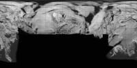
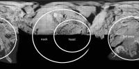
Ok... I have been taking some time out from what I should really be doing - finishing a book (Emily will understand this) - to play around with some ideas about what a map of 'the nucleus that dare not speak its name' should look like.
Let me preface this by saying - this is a horrible map, very distorted and inaccurate, and the Rosetta team will do much better soon and completely discredit me. This is only intended to illustrate roughly what a proper map might look like. It's cylindrical, so the projection is very distorted to begin with. We had a video of a shape with a lat-long grid, so that forms the basis of my coordinate system. I took images from orientations which roughly matched frames from the video and overlaid them. Two sources of error immediately - the shape was based on low res images and will not fit high res images very well to begin with, and the overlay is only approximate due to different view directions, so it's hard to match positions properly. Then I copied areas grid cell by grid cell and pasted them and distorted them to fit the grid. Lots of problems and bad fits especially in the neck area, obviously. The grid is spaced at 15 degrees like the shape model video grid. Longitude 180 is in the middle. A separate version is annotated to show where the main features are. Phil
-------------------- ... because the Solar System ain't gonna map itself.
Also to be found posting similar content on https://mastodon.social/@PhilStooke Maps for download (free PD: https://upload.wikimedia.org/wikipedia/comm...Cartography.pdf NOTE: everything created by me which I post on UMSF is considered to be in the public domain (NOT CC, public domain) |
||
|
|
|
||
 Phil Stooke 3D shape, cartography, and geoid of Comet 67P C-G Aug 6 2014, 02:11 PM
 acastillo It would appear that the neck is an "erosiona... Aug 6 2014, 02:44 PM
 AndyG QUOTE (acastillo @ Aug 6 2014, 03:44 PM) ... Aug 6 2014, 03:47 PM TheAnt QUOTE (acastillo @ Aug 6 2014, 04:44 PM) ... Aug 6 2014, 04:46 PM
 mcgyver QUOTE (acastillo @ Aug 6 2014, 03:44 PM) ... Aug 8 2014, 07:47 PM Phil Stooke Not a pain, it just means the cartographers have l... Aug 8 2014, 08:04 PM Explorer1 Wouldn't the two lobes just gradually come bac... Aug 8 2014, 08:06 PM Mercure I believe the centrifugal forces at the rotational... Aug 8 2014, 10:05 PM Phil Stooke I think you're right, the lobes would collapse... Aug 8 2014, 10:00 PM djellison Rotation rate is 12.7 hours. The circumference dr... Aug 8 2014, 10:17 PM nprev The key variable between these scenarios is mass, ... Aug 8 2014, 10:20 PM ngunn Every irregular object eroded from the outside mus... Aug 8 2014, 10:22 PM nprev Could acquire more angular momentum from impacts o... Aug 8 2014, 10:28 PM djellison If it were rotating fast enough to displace the tw... Aug 8 2014, 10:37 PM SteveM I'm not convinced by the emerging consensus th... Aug 8 2014, 10:42 PM djellison QUOTE (SteveM @ Aug 8 2014, 03:42 PM) I... Aug 8 2014, 11:10 PM Y Bar Ranch QUOTE (SteveM @ Aug 8 2014, 05:42 PM) I... Aug 11 2014, 02:16 PM djellison QUOTE (Y Bar Ranch @ Aug 11 2014, 07:16 A... Aug 11 2014, 02:47 PM Y Bar Ranch QUOTE (djellison @ Aug 11 2014, 09:47 AM)... Aug 11 2014, 04:02 PM ngunn QUOTE (Y Bar Ranch @ Aug 11 2014, 03:16 P... Aug 11 2014, 02:48 PM Greenish I had been curious about the gravity field so was ... Aug 9 2014, 01:42 AM machi According to my calculations gravity/centripetal r... Aug 9 2014, 01:53 AM Adam Hurcewicz OK, here is visualization from Celestia. I made mo... Aug 10 2014, 05:16 PM Gerald For 67P/C-G, and similarly asymmetric bodies, I... Aug 10 2014, 06:03 PM fredk QUOTE (Gerald @ Aug 10 2014, 06:03 PM) Pr... Aug 10 2014, 06:38 PM Harder thanks, Gerald, for your insights. I noticed you f... Aug 10 2014, 06:36 PM Gerald QUOTE (Harder @ Aug 10 2014, 08:38 PM) ..... Aug 10 2014, 07:11 PM Phil Stooke The up and down can be incorporated into topograph... Aug 10 2014, 09:43 PM JohnVV the problem at this time is we do not have a mesh ... Aug 10 2014, 11:38 PM Gerald If you take a binary of two spherical bodies, the ... Aug 11 2014, 03:37 PM Y Bar Ranch QUOTE (Gerald @ Aug 11 2014, 10:37 AM) If... Aug 11 2014, 04:08 PM Gerald QUOTE (Y Bar Ranch @ Aug 11 2014, 06:08 P... Aug 11 2014, 04:36 PM ngunn QUOTE (Y Bar Ranch @ Aug 11 2014, 05:08 P... Aug 11 2014, 04:42 PM Y Bar Ranch QUOTE (ngunn @ Aug 11 2014, 12:42 PM) I r... Aug 11 2014, 04:50 PM MoreInput Thanks for the map, Phil.
What about the idea to ... Aug 16 2014, 08:46 PM Explorer1 Very impressive! The axis must be tilted quite... Aug 15 2014, 07:13 PM wildespace I have seen members here mention generating synthe... Aug 16 2014, 07:54 AM ngunn That same idea occurred to me: map them separately... Aug 16 2014, 09:42 PM JohnVV this gif animation ( pre orbit data )
http://sci... Aug 17 2014, 04:55 AM mcgyver QUOTE (JohnVV @ Aug 17 2014, 04:55 AM) th... Aug 22 2014, 02:13 PM Phil Stooke Re - mapping the lobes separately - it's an in... Aug 17 2014, 05:33 AM JohnVV still working on this , just an early preview
... Aug 20 2014, 10:26 PM Phil Stooke JohnVV wrote:
I was able to extract a pointcloud ... Aug 22 2014, 03:39 AM JohnVV phil
there is a zip with a obj mesh in it here
ht... Aug 22 2014, 03:50 AM Malmer I'm playing around making a highresolution 3D ... Aug 22 2014, 04:07 PM JohnVV QUOTE (Malmer @ Aug 22 2014, 12:07 PM) I... Aug 23 2014, 01:35 AM Malmer QUOTE (JohnVV @ Aug 23 2014, 03:35 AM) ni... Aug 23 2014, 06:42 AM mcgyver QUOTE (Malmer @ Aug 22 2014, 04:07 PM) I... Aug 23 2014, 10:06 PM Malmer QUOTE (mcgyver @ Aug 24 2014, 12:06 AM) S... Aug 23 2014, 10:42 PM Toma B QUOTE (Malmer @ Aug 24 2014, 12:42 AM) I ... Aug 24 2014, 10:07 AM JohnVV QUOTE Do you explain somewhere the method you used... Aug 22 2014, 05:50 PM Phil Stooke Hi Malmer - cartographers have already discussed t... Aug 23 2014, 02:37 PM Malmer For my own selfish purposes I will probably use so... Aug 23 2014, 05:36 PM machi QUOTE (wildespace @ Aug 16 2014, 09:54 AM... Aug 25 2014, 10:42 AM Gerald QUOTE (machi @ Aug 25 2014, 12:42 PM) ...... Aug 25 2014, 12:08 PM JohnVV QUOTE t would be interesting to see a map of where... Sep 2 2014, 11:41 PM Malmer QUOTE (JohnVV @ Sep 3 2014, 01:41 AM) dow... Sep 3 2014, 11:49 AM charborob What I would like to see is an image of the comet ... Sep 3 2014, 12:42 AM SteveM QUOTE (charborob @ Sep 2 2014, 07:42 PM) ... Sep 3 2014, 01:20 AM JohnVV with "Down as the direction of the SouthPole ... Sep 3 2014, 01:08 AM JohnVV QUOTE Is that your own shapemodel or is it somethi... Sep 3 2014, 05:14 PM Malmer QUOTE (JohnVV @ Sep 3 2014, 07:14 PM) no ... Sep 3 2014, 08:54 PM Y Bar Ranch I'd be interested in grabbing whatever you guy... Sep 3 2014, 09:09 PM Malmer Will post as soon as it is resonably correct. Sep 3 2014, 09:48 PM Phil Stooke I am very impressed by this, John! Looking fo... Sep 3 2014, 06:05 PM JohnVV QUOTE I'd be interested in grabbing whatever y... Sep 3 2014, 09:50 PM Malmer QUOTE (JohnVV @ Sep 3 2014, 11:50 PM) i j... Sep 3 2014, 10:32 PM CAP-Team QUOTE (JohnVV @ Sep 3 2014, 11:50 PM) i j... Sep 4 2014, 06:50 PM mcgyver QUOTE (CAP-Team @ Sep 4 2014, 06:50 ... Sep 4 2014, 07:08 PM djellison QUOTE (mcgyver @ Sep 4 2014, 12:08 PM) Wh... Sep 4 2014, 09:09 PM Malmer QUOTE (JohnVV @ Sep 3 2014, 11:50 PM) i j... Sep 4 2014, 11:05 PM JohnVV 3ds to cmod is rather easy
now the plugin is for ... Sep 4 2014, 08:11 PM Malmer QUOTE (JohnVV @ Sep 4 2014, 10:11 PM) 3ds... Sep 4 2014, 08:33 PM Gerald Some qualitative sensitivity analysis of trajector... Sep 4 2014, 10:07 PM fredk Nice. So did you chose the rotation axis to be pe... Sep 4 2014, 10:23 PM Gerald Yes. Sep 4 2014, 10:30 PM JohnVV Blender is not a "cad/cam" set-up
so th... Sep 5 2014, 06:47 PM Malmer QUOTE (JohnVV @ Sep 5 2014, 08:47 PM) Ble... Sep 5 2014, 07:04 PM JohnVV well the landing site is near 190 long and just a ... Sep 16 2014, 05:44 AM JohnVV with the few images and the video
"Possible ... Sep 24 2014, 12:43 AM Malmer QUOTE (JohnVV @ Sep 24 2014, 02:43 AM) wi... Sep 24 2014, 01:17 AM JohnVV from the image
"Comet_on_16_August_c.jpg... Sep 24 2014, 02:25 AM
mcgyver QUOTE (acastillo @ Aug 6 2014, 03:44 PM) ... Aug 8 2014, 07:47 PM Phil Stooke Not a pain, it just means the cartographers have l... Aug 8 2014, 08:04 PM Explorer1 Wouldn't the two lobes just gradually come bac... Aug 8 2014, 08:06 PM Mercure I believe the centrifugal forces at the rotational... Aug 8 2014, 10:05 PM Phil Stooke I think you're right, the lobes would collapse... Aug 8 2014, 10:00 PM djellison Rotation rate is 12.7 hours. The circumference dr... Aug 8 2014, 10:17 PM nprev The key variable between these scenarios is mass, ... Aug 8 2014, 10:20 PM ngunn Every irregular object eroded from the outside mus... Aug 8 2014, 10:22 PM nprev Could acquire more angular momentum from impacts o... Aug 8 2014, 10:28 PM djellison If it were rotating fast enough to displace the tw... Aug 8 2014, 10:37 PM SteveM I'm not convinced by the emerging consensus th... Aug 8 2014, 10:42 PM djellison QUOTE (SteveM @ Aug 8 2014, 03:42 PM) I... Aug 8 2014, 11:10 PM Y Bar Ranch QUOTE (SteveM @ Aug 8 2014, 05:42 PM) I... Aug 11 2014, 02:16 PM djellison QUOTE (Y Bar Ranch @ Aug 11 2014, 07:16 A... Aug 11 2014, 02:47 PM Y Bar Ranch QUOTE (djellison @ Aug 11 2014, 09:47 AM)... Aug 11 2014, 04:02 PM ngunn QUOTE (Y Bar Ranch @ Aug 11 2014, 03:16 P... Aug 11 2014, 02:48 PM Greenish I had been curious about the gravity field so was ... Aug 9 2014, 01:42 AM machi According to my calculations gravity/centripetal r... Aug 9 2014, 01:53 AM Adam Hurcewicz OK, here is visualization from Celestia. I made mo... Aug 10 2014, 05:16 PM Gerald For 67P/C-G, and similarly asymmetric bodies, I... Aug 10 2014, 06:03 PM fredk QUOTE (Gerald @ Aug 10 2014, 06:03 PM) Pr... Aug 10 2014, 06:38 PM Harder thanks, Gerald, for your insights. I noticed you f... Aug 10 2014, 06:36 PM Gerald QUOTE (Harder @ Aug 10 2014, 08:38 PM) ..... Aug 10 2014, 07:11 PM Phil Stooke The up and down can be incorporated into topograph... Aug 10 2014, 09:43 PM JohnVV the problem at this time is we do not have a mesh ... Aug 10 2014, 11:38 PM Gerald If you take a binary of two spherical bodies, the ... Aug 11 2014, 03:37 PM Y Bar Ranch QUOTE (Gerald @ Aug 11 2014, 10:37 AM) If... Aug 11 2014, 04:08 PM Gerald QUOTE (Y Bar Ranch @ Aug 11 2014, 06:08 P... Aug 11 2014, 04:36 PM ngunn QUOTE (Y Bar Ranch @ Aug 11 2014, 05:08 P... Aug 11 2014, 04:42 PM Y Bar Ranch QUOTE (ngunn @ Aug 11 2014, 12:42 PM) I r... Aug 11 2014, 04:50 PM MoreInput Thanks for the map, Phil.
What about the idea to ... Aug 16 2014, 08:46 PM Explorer1 Very impressive! The axis must be tilted quite... Aug 15 2014, 07:13 PM wildespace I have seen members here mention generating synthe... Aug 16 2014, 07:54 AM ngunn That same idea occurred to me: map them separately... Aug 16 2014, 09:42 PM JohnVV this gif animation ( pre orbit data )
http://sci... Aug 17 2014, 04:55 AM mcgyver QUOTE (JohnVV @ Aug 17 2014, 04:55 AM) th... Aug 22 2014, 02:13 PM Phil Stooke Re - mapping the lobes separately - it's an in... Aug 17 2014, 05:33 AM JohnVV still working on this , just an early preview
... Aug 20 2014, 10:26 PM Phil Stooke JohnVV wrote:
I was able to extract a pointcloud ... Aug 22 2014, 03:39 AM JohnVV phil
there is a zip with a obj mesh in it here
ht... Aug 22 2014, 03:50 AM Malmer I'm playing around making a highresolution 3D ... Aug 22 2014, 04:07 PM JohnVV QUOTE (Malmer @ Aug 22 2014, 12:07 PM) I... Aug 23 2014, 01:35 AM Malmer QUOTE (JohnVV @ Aug 23 2014, 03:35 AM) ni... Aug 23 2014, 06:42 AM mcgyver QUOTE (Malmer @ Aug 22 2014, 04:07 PM) I... Aug 23 2014, 10:06 PM Malmer QUOTE (mcgyver @ Aug 24 2014, 12:06 AM) S... Aug 23 2014, 10:42 PM Toma B QUOTE (Malmer @ Aug 24 2014, 12:42 AM) I ... Aug 24 2014, 10:07 AM JohnVV QUOTE Do you explain somewhere the method you used... Aug 22 2014, 05:50 PM Phil Stooke Hi Malmer - cartographers have already discussed t... Aug 23 2014, 02:37 PM Malmer For my own selfish purposes I will probably use so... Aug 23 2014, 05:36 PM machi QUOTE (wildespace @ Aug 16 2014, 09:54 AM... Aug 25 2014, 10:42 AM Gerald QUOTE (machi @ Aug 25 2014, 12:42 PM) ...... Aug 25 2014, 12:08 PM JohnVV QUOTE t would be interesting to see a map of where... Sep 2 2014, 11:41 PM Malmer QUOTE (JohnVV @ Sep 3 2014, 01:41 AM) dow... Sep 3 2014, 11:49 AM charborob What I would like to see is an image of the comet ... Sep 3 2014, 12:42 AM SteveM QUOTE (charborob @ Sep 2 2014, 07:42 PM) ... Sep 3 2014, 01:20 AM JohnVV with "Down as the direction of the SouthPole ... Sep 3 2014, 01:08 AM JohnVV QUOTE Is that your own shapemodel or is it somethi... Sep 3 2014, 05:14 PM Malmer QUOTE (JohnVV @ Sep 3 2014, 07:14 PM) no ... Sep 3 2014, 08:54 PM Y Bar Ranch I'd be interested in grabbing whatever you guy... Sep 3 2014, 09:09 PM Malmer Will post as soon as it is resonably correct. Sep 3 2014, 09:48 PM Phil Stooke I am very impressed by this, John! Looking fo... Sep 3 2014, 06:05 PM JohnVV QUOTE I'd be interested in grabbing whatever y... Sep 3 2014, 09:50 PM Malmer QUOTE (JohnVV @ Sep 3 2014, 11:50 PM) i j... Sep 3 2014, 10:32 PM CAP-Team QUOTE (JohnVV @ Sep 3 2014, 11:50 PM) i j... Sep 4 2014, 06:50 PM mcgyver QUOTE (CAP-Team @ Sep 4 2014, 06:50 ... Sep 4 2014, 07:08 PM djellison QUOTE (mcgyver @ Sep 4 2014, 12:08 PM) Wh... Sep 4 2014, 09:09 PM Malmer QUOTE (JohnVV @ Sep 3 2014, 11:50 PM) i j... Sep 4 2014, 11:05 PM JohnVV 3ds to cmod is rather easy
now the plugin is for ... Sep 4 2014, 08:11 PM Malmer QUOTE (JohnVV @ Sep 4 2014, 10:11 PM) 3ds... Sep 4 2014, 08:33 PM Gerald Some qualitative sensitivity analysis of trajector... Sep 4 2014, 10:07 PM fredk Nice. So did you chose the rotation axis to be pe... Sep 4 2014, 10:23 PM Gerald Yes. Sep 4 2014, 10:30 PM JohnVV Blender is not a "cad/cam" set-up
so th... Sep 5 2014, 06:47 PM Malmer QUOTE (JohnVV @ Sep 5 2014, 08:47 PM) Ble... Sep 5 2014, 07:04 PM JohnVV well the landing site is near 190 long and just a ... Sep 16 2014, 05:44 AM JohnVV with the few images and the video
"Possible ... Sep 24 2014, 12:43 AM Malmer QUOTE (JohnVV @ Sep 24 2014, 02:43 AM) wi... Sep 24 2014, 01:17 AM JohnVV from the image
"Comet_on_16_August_c.jpg... Sep 24 2014, 02:25 AM |

|
Lo-Fi Version | Time is now: 2nd June 2024 - 03:15 AM |
|
RULES AND GUIDELINES Please read the Forum Rules and Guidelines before posting. IMAGE COPYRIGHT |
OPINIONS AND MODERATION Opinions expressed on UnmannedSpaceflight.com are those of the individual posters and do not necessarily reflect the opinions of UnmannedSpaceflight.com or The Planetary Society. The all-volunteer UnmannedSpaceflight.com moderation team is wholly independent of The Planetary Society. The Planetary Society has no influence over decisions made by the UnmannedSpaceflight.com moderators. |
SUPPORT THE FORUM Unmannedspaceflight.com is funded by the Planetary Society. Please consider supporting our work and many other projects by donating to the Society or becoming a member. |
|