Crossing the Dunes at Murray Buttes, Sites 54-62, Sols 1353-1659, May 28 2016-Apr 6 2017 |

Crossing the Dunes at Murray Buttes, Sites 54-62, Sols 1353-1659, May 28 2016-Apr 6 2017 |
 May 27 2016, 11:01 AM May 27 2016, 11:01 AM
Post
#1
|
||
 Senior Member  Group: Members Posts: 2431 Joined: 30-January 13 From: Penang, Malaysia. Member No.: 6853 |
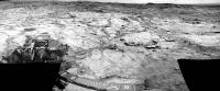
Midnight Planets has reported Curiosity's movement of ~46.3m WSW (-116º) on Sol 1353.
Only 7 L-NavCams were available for this rough & ready stitch in MS ICE, the raws are a little overexposed, but they may assist in pinpointing the location. I cropped the stitch a little to get it under the upload limit. I'll post the full resolution 360 on an image host as the images become available, unless someone beats me to it 
|
|
 |
 
|
|
 |
|
Jun 2 2016, 02:18 PM
Post
#2
|
|
 Administrator Group: Admin Posts: 5172 Joined: 4-August 05 From: Pasadena, CA, USA, Earth Member No.: 454 |
It's fascinating how dark the dump pile looks in Navcam. Navcams have red/IR filters on them (600-800nm), so the (relatively) blue tailings pile looks a lot darker to Navcam than it does to Mastcam/MAHLI.
-------------------- My website - My Patreon - @elakdawalla on Twitter - Please support unmannedspaceflight.com by donating here.
|
|
|
|
|
Jun 2 2016, 11:01 PM
Post
#3
|
|
|
Senior Member Group: Members Posts: 2431 Joined: 30-January 13 From: Penang, Malaysia. Member No.: 6853 |
QUOTE (elakdawalla @ Jun 2 2016, 10:18 PM)  It's fascinating how dark the dump pile looks in Navcam. When I shared that image elsewhere I had to add an arrow to point out the dump pile on the NavCam context image due to apparent colour differences And the latest from USGS:- Curiosity Mission Update by Ken Herkenhoff, dated 02 Jun 2016 - Sol 1360: Preparing to drill QUOTE Arm work continues to go well, so preparation for drilling and sample analysis is the focus of the Sol 1360 plan. First, CheMin will dump the Lubango and Okoruso drill samples out of their cells. Then ChemCam and Mastcam will observe a bright vein named "Charlottenfelder" and a bedrock target called "Chameis Bay" before arm activities resume. MAHLI will take close-up images of the Oudam drill target and a single image of the "footprint" that APXS likely made on the Okoruso dump pile yesterday. Overnight, CheMin will analyze an empty cell to provide a baseline measurement before receiving the new drill sample. Early the next morning, before handover to the next plan, observations of the Sun and sky will measure dust in the atmosphere over the rover and search for clouds and dust devils. The Right Mastcam will take a 10-image mosaic of the "Otjizonjati" outcrop northwest of the rover when it is well-illuminated by the morning sun. Finally, the RMI will acquire a 5-image mosaic of part of Aeolis Mons (Mount Sharp) toward the south. |
|
|
|
 PaulH51 Crossing the Dunes at Murray Buttes May 27 2016, 11:01 AM
 PaulH51 Curiosity Mission Update by Ryan Anderson, dated 2... May 28 2016, 03:49 AM PaulH51 L-MastCam Sol 1353 - 6 frame mosaic of Curiosity... May 29 2016, 03:38 AM PaulH51 R-NavCam Sol 1353 Pano, complete with some data-dr... May 29 2016, 04:07 AM Phil Stooke Here is Paul's full panorama from sol 1353 in ... May 30 2016, 05:53 AM PaulH51 Sol 1356: Long-Distance ChemCam-RMI mosaic, center... May 31 2016, 01:04 AM
 HSchirmer QUOTE (PaulH51 @ May 31 2016, 02:04 AM) S... May 31 2016, 02:20 AM elakdawalla New thread time! Now that Curiosity's whee... May 31 2016, 03:24 PM PaulH51 Another drive on sol 1357: ~7 meters West followed... May 31 2016, 11:16 PM PaulH51 Curiosity Mission Update by Ryan anderson, dated 3... Jun 1 2016, 11:04 PM PaulH51 Sol 1358: The Okoruso drill sample dumped from CHI... Jun 2 2016, 01:25 AM elakdawalla I didn't expect them to drill again so soon. I... Jun 2 2016, 11:04 PM PaulH51 QUOTE (elakdawalla @ Jun 3 2016, 07:04 AM... Jun 3 2016, 01:04 AM jvandriel The Navcam L view on Sol 1357.
Jan van Driel
Jun 3 2016, 07:29 PM PaulH51 Curiosity Mission Update by Ken Herkenhoff, dated ... Jun 4 2016, 03:03 AM PaulH51 Sol 1361 MAHLI, our latest sample hole at Oudam
Jun 4 2016, 09:57 PM elakdawalla Also:
Jun 4 2016, 10:18 PM PaulH51 Always enjoy Emily's montage's of MSL... Jun 5 2016, 02:03 AM James Sorenson Here is my version of the drill hole gif. I haven... Jun 6 2016, 02:01 AM James Sorenson Oh and that penny in the future image of the hole ... Jun 6 2016, 03:11 AM PaulH51 Sol 1363 L-MastCam Rover Deck / CHEMIN Inlet Port ... Jun 7 2016, 03:58 AM James Sorenson QUOTE (PaulH51 @ Jun 6 2016, 08:58 PM) No... Jun 7 2016, 07:43 AM PaulH51 QUOTE (James Sorenson @ Jun 7 2016, 03:43... Jun 7 2016, 08:09 AM HSchirmer QUOTE (PaulH51 @ Jun 7 2016, 09:09 AM) As... Jun 7 2016, 11:36 AM PaulH51 QUOTE (HSchirmer @ Jun 7 2016, 07:36 PM) ... Jun 7 2016, 11:53 AM PaulH51 More mud cracks? (raw Sol 1352 R-MastCam)
Edit...... Jun 7 2016, 05:58 AM fredk The pattern was visible on sol 36 - look along the... Jun 7 2016, 03:14 PM HSchirmer QUOTE (fredk @ Jun 7 2016, 03:14 PM) Is h... Jun 7 2016, 05:59 PM Art Martin Could it simply be that the material used for the ... Jun 7 2016, 06:28 PM PaulH51 Curiosity Mission Update by Ken Herkenhoff, dated ... Jun 8 2016, 01:22 AM James Sorenson I like the "UV darkening of the adhesive... Jun 8 2016, 05:31 AM PaulH51 QUOTE (James Sorenson @ Jun 8 2016, 01:31... Jun 8 2016, 11:31 AM mcaplinger QUOTE (James Sorenson @ Jun 7 2016, 09:31... Jun 8 2016, 03:54 PM HSchirmer QUOTE (mcaplinger @ Jun 8 2016, 03:54 PM)... Jun 8 2016, 04:52 PM Steve5304 So this pretty much tells us mars atmosphere eats ... Jun 8 2016, 07:02 PM HSchirmer QUOTE (Steve5304 @ Jun 8 2016, 07:02 PM) ... Jun 8 2016, 07:28 PM mcaplinger QUOTE (HSchirmer @ Jun 8 2016, 11:28 AM) ... Jun 8 2016, 08:32 PM PaulH51 QUOTE (mcaplinger @ Jun 9 2016, 04:32 AM)... Jun 8 2016, 08:49 PM mcaplinger QUOTE (PaulH51 @ Jun 8 2016, 12:49 PM) Th... Jun 8 2016, 09:24 PM HSchirmer QUOTE (mcaplinger @ Jun 8 2016, 09:24 PM)... Jun 8 2016, 09:31 PM mcaplinger QUOTE (HSchirmer @ Jun 8 2016, 01:31 PM) ... Jun 8 2016, 10:35 PM fredk How does it tell us that? The anodized coating fl... Jun 8 2016, 07:07 PM serpens Kudos to fredk for the insight on phase angle whic... Jun 8 2016, 11:10 PM PaulH51 QUOTE (serpens @ Jun 9 2016, 07:10 AM) Ku... Jun 9 2016, 03:10 AM PaulH51 Peeling Back the History of Mars, One Layer at a T... Jun 9 2016, 10:28 AM Fran Ontanaya If you look at the shadows, that elongated feature... Jun 9 2016, 10:37 AM PaulH51 QUOTE (Fran Ontanaya @ Jun 9 2016, 06:37 ... Jun 9 2016, 01:41 PM atomoid Mars never ceases to amaze! here are stereos (... Jun 9 2016, 09:34 PM serpens Almost nearly but not quite as impressive as Oppor... Jun 9 2016, 10:58 PM atomoid those Oppy berries on stalks were impressive, and ... Jun 10 2016, 01:06 AM PaulH51 QUOTE (atomoid @ Jun 10 2016, 09:06 AM) t... Jun 10 2016, 05:23 AM Phil Stooke A bit late, but I've been on the Moon. This i... Jun 10 2016, 01:01 PM PaulH51 Montage of sol 1366 images featuring what could be... Jun 11 2016, 07:15 AM PaulH51 Just in case you hadn't noticed, Curioity... Jun 12 2016, 08:53 PM PaulH51 Sol 1357/1368 comparison:
Looking for changes and ... Jun 13 2016, 01:00 AM fredk Yeah, that was very close to the drill site as thi... Jun 13 2016, 04:25 AM PaulH51 Sol 1369 drive by Curiosity, drive details current... Jun 13 2016, 07:28 AM Phil Stooke Thanks Paul - I am completely reliant on our benef... Jun 13 2016, 04:03 PM PaulH51 QUOTE (Phil Stooke @ Jun 14 2016, 12:03 A... Jun 13 2016, 09:07 PM john_s Well that's bizarre- I'm also on holiday i... Jun 13 2016, 09:14 PM Sean Here is a 3D model of Curi in situ on Sol 1357, sc... Jun 13 2016, 04:17 PM PaulH51 QUOTE (Sean @ Jun 14 2016, 12:17 AM) Here... Jun 13 2016, 09:11 PM Phil Stooke Hi John! I leave tomorrow too.
Phil Jun 13 2016, 10:01 PM PaulH51 JPL have issued PIA20748 on its Photojournal page,... Jun 14 2016, 11:19 AM Gerald Nice synopsis of the drill holes!
The Oudam dr... Jun 14 2016, 01:16 PM jvandriel The complete Navcam L view on Sol 1369.
Jan van D... Jun 14 2016, 02:35 PM Phil Stooke Thanks, Jan - here is a circular version, giving a... Jun 14 2016, 05:23 PM fredk Phil route map for sol 1371:
The locations are pr... Jun 14 2016, 06:05 PM Phil Stooke Genius! But you're in the wrong thread...... Jun 14 2016, 06:53 PM PaulH51 Curiosity Mission Update by Lauren Edgar, dated 13... Jun 14 2016, 10:02 PM PaulH51 As planned a drive on sol 1371, only have a partia... Jun 15 2016, 02:58 PM Phil Stooke Alas, I think I need the Full Monty (AKA a 360 deg... Jun 15 2016, 03:59 PM Sean Here is a quick stitch of the pano from Sol 1367 M... Jun 15 2016, 08:46 PM PaulH51 The full 360 pano, sol 1371 R-MastCam (MS ICE C/W ... Jun 15 2016, 11:20 PM Phil Stooke Now I can locate the rover! Here is a circula... Jun 16 2016, 08:35 PM Sean Here is an updated model showing Curi's curren... Jun 17 2016, 04:10 AM Sean Sol 1373 NR 360...
All sizes
Is it me or did F... Jun 17 2016, 01:34 PM jvandriel Here is my view of the Sol 1373 NL B panorama.
Ja... Jun 17 2016, 02:20 PM Phil Stooke Thanks, Jan, and here it is in a circular version.... Jun 17 2016, 06:19 PM PaulH51 Curiosity Mission Update by Ken Herkenhoff, Dated ... Jun 18 2016, 06:48 AM PaulH51 For those of you who have missed it as much as I h... Jun 19 2016, 03:45 AM PaulH51 125 frame, L-MastCam panorama (sol 1367) MS ICE wi... Jun 19 2016, 12:56 PM PaulH51 Sol 1376 End of Drive partial L-NavCam mosaic. At ... Jun 20 2016, 04:31 AM Phil Stooke It does help! Here is a semicircular version:... Jun 20 2016, 09:50 AM Sean Paul, I took your view and did a quick compare wit... Jun 20 2016, 11:48 AM PaulH51 QUOTE (Sean @ Jun 20 2016, 07:48 PM) Paul... Jun 20 2016, 11:58 AM scalbers That's really neat with the 3-D modeling from ... Jun 20 2016, 04:17 PM Sean Yes Herobrine has done some excellent work in that... Jun 20 2016, 05:13 PM atomoid that's really cool, i could lose my whole day ... Jun 20 2016, 10:01 PM Sean I'm hoping for some improvement in the sensiti... Jun 20 2016, 11:09 PM Phil Stooke Thanks, Sean - here is a circular version.
Phil
Jun 21 2016, 07:43 AM PaulH51 Curiosity Mission Update by Ryan Anderson: Dated 2... Jun 22 2016, 02:22 AM PaulH51 Midnight Planets reports that Curiosity moved appr... Jun 22 2016, 08:24 AM jvandriel The Navcam L view on Sol 1378.
Jan van Driel
Jun 22 2016, 05:12 PM Phil Stooke Here's a quick circular version of that pan - ... Jun 22 2016, 06:59 PM Sean Sol 1375 MR crop Jun 22 2016, 11:41 PM PaulH51 QUOTE (Sean @ Jun 23 2016, 07:41 AM) Sol ... Jun 23 2016, 06:10 AM PaulH51 Curiosity Mission Update by Lauren Edgar: Dated 22... Jun 23 2016, 11:10 AM
HSchirmer QUOTE (PaulH51 @ May 31 2016, 02:04 AM) S... May 31 2016, 02:20 AM elakdawalla New thread time! Now that Curiosity's whee... May 31 2016, 03:24 PM PaulH51 Another drive on sol 1357: ~7 meters West followed... May 31 2016, 11:16 PM PaulH51 Curiosity Mission Update by Ryan anderson, dated 3... Jun 1 2016, 11:04 PM PaulH51 Sol 1358: The Okoruso drill sample dumped from CHI... Jun 2 2016, 01:25 AM elakdawalla I didn't expect them to drill again so soon. I... Jun 2 2016, 11:04 PM PaulH51 QUOTE (elakdawalla @ Jun 3 2016, 07:04 AM... Jun 3 2016, 01:04 AM jvandriel The Navcam L view on Sol 1357.
Jan van Driel
Jun 3 2016, 07:29 PM PaulH51 Curiosity Mission Update by Ken Herkenhoff, dated ... Jun 4 2016, 03:03 AM PaulH51 Sol 1361 MAHLI, our latest sample hole at Oudam
Jun 4 2016, 09:57 PM elakdawalla Also:
Jun 4 2016, 10:18 PM PaulH51 Always enjoy Emily's montage's of MSL... Jun 5 2016, 02:03 AM James Sorenson Here is my version of the drill hole gif. I haven... Jun 6 2016, 02:01 AM James Sorenson Oh and that penny in the future image of the hole ... Jun 6 2016, 03:11 AM PaulH51 Sol 1363 L-MastCam Rover Deck / CHEMIN Inlet Port ... Jun 7 2016, 03:58 AM James Sorenson QUOTE (PaulH51 @ Jun 6 2016, 08:58 PM) No... Jun 7 2016, 07:43 AM PaulH51 QUOTE (James Sorenson @ Jun 7 2016, 03:43... Jun 7 2016, 08:09 AM HSchirmer QUOTE (PaulH51 @ Jun 7 2016, 09:09 AM) As... Jun 7 2016, 11:36 AM PaulH51 QUOTE (HSchirmer @ Jun 7 2016, 07:36 PM) ... Jun 7 2016, 11:53 AM PaulH51 More mud cracks? (raw Sol 1352 R-MastCam)
Edit...... Jun 7 2016, 05:58 AM fredk The pattern was visible on sol 36 - look along the... Jun 7 2016, 03:14 PM HSchirmer QUOTE (fredk @ Jun 7 2016, 03:14 PM) Is h... Jun 7 2016, 05:59 PM Art Martin Could it simply be that the material used for the ... Jun 7 2016, 06:28 PM PaulH51 Curiosity Mission Update by Ken Herkenhoff, dated ... Jun 8 2016, 01:22 AM James Sorenson I like the "UV darkening of the adhesive... Jun 8 2016, 05:31 AM PaulH51 QUOTE (James Sorenson @ Jun 8 2016, 01:31... Jun 8 2016, 11:31 AM mcaplinger QUOTE (James Sorenson @ Jun 7 2016, 09:31... Jun 8 2016, 03:54 PM HSchirmer QUOTE (mcaplinger @ Jun 8 2016, 03:54 PM)... Jun 8 2016, 04:52 PM Steve5304 So this pretty much tells us mars atmosphere eats ... Jun 8 2016, 07:02 PM HSchirmer QUOTE (Steve5304 @ Jun 8 2016, 07:02 PM) ... Jun 8 2016, 07:28 PM mcaplinger QUOTE (HSchirmer @ Jun 8 2016, 11:28 AM) ... Jun 8 2016, 08:32 PM PaulH51 QUOTE (mcaplinger @ Jun 9 2016, 04:32 AM)... Jun 8 2016, 08:49 PM mcaplinger QUOTE (PaulH51 @ Jun 8 2016, 12:49 PM) Th... Jun 8 2016, 09:24 PM HSchirmer QUOTE (mcaplinger @ Jun 8 2016, 09:24 PM)... Jun 8 2016, 09:31 PM mcaplinger QUOTE (HSchirmer @ Jun 8 2016, 01:31 PM) ... Jun 8 2016, 10:35 PM fredk How does it tell us that? The anodized coating fl... Jun 8 2016, 07:07 PM serpens Kudos to fredk for the insight on phase angle whic... Jun 8 2016, 11:10 PM PaulH51 QUOTE (serpens @ Jun 9 2016, 07:10 AM) Ku... Jun 9 2016, 03:10 AM PaulH51 Peeling Back the History of Mars, One Layer at a T... Jun 9 2016, 10:28 AM Fran Ontanaya If you look at the shadows, that elongated feature... Jun 9 2016, 10:37 AM PaulH51 QUOTE (Fran Ontanaya @ Jun 9 2016, 06:37 ... Jun 9 2016, 01:41 PM atomoid Mars never ceases to amaze! here are stereos (... Jun 9 2016, 09:34 PM serpens Almost nearly but not quite as impressive as Oppor... Jun 9 2016, 10:58 PM atomoid those Oppy berries on stalks were impressive, and ... Jun 10 2016, 01:06 AM PaulH51 QUOTE (atomoid @ Jun 10 2016, 09:06 AM) t... Jun 10 2016, 05:23 AM Phil Stooke A bit late, but I've been on the Moon. This i... Jun 10 2016, 01:01 PM PaulH51 Montage of sol 1366 images featuring what could be... Jun 11 2016, 07:15 AM PaulH51 Just in case you hadn't noticed, Curioity... Jun 12 2016, 08:53 PM PaulH51 Sol 1357/1368 comparison:
Looking for changes and ... Jun 13 2016, 01:00 AM fredk Yeah, that was very close to the drill site as thi... Jun 13 2016, 04:25 AM PaulH51 Sol 1369 drive by Curiosity, drive details current... Jun 13 2016, 07:28 AM Phil Stooke Thanks Paul - I am completely reliant on our benef... Jun 13 2016, 04:03 PM PaulH51 QUOTE (Phil Stooke @ Jun 14 2016, 12:03 A... Jun 13 2016, 09:07 PM john_s Well that's bizarre- I'm also on holiday i... Jun 13 2016, 09:14 PM Sean Here is a 3D model of Curi in situ on Sol 1357, sc... Jun 13 2016, 04:17 PM PaulH51 QUOTE (Sean @ Jun 14 2016, 12:17 AM) Here... Jun 13 2016, 09:11 PM Phil Stooke Hi John! I leave tomorrow too.
Phil Jun 13 2016, 10:01 PM PaulH51 JPL have issued PIA20748 on its Photojournal page,... Jun 14 2016, 11:19 AM Gerald Nice synopsis of the drill holes!
The Oudam dr... Jun 14 2016, 01:16 PM jvandriel The complete Navcam L view on Sol 1369.
Jan van D... Jun 14 2016, 02:35 PM Phil Stooke Thanks, Jan - here is a circular version, giving a... Jun 14 2016, 05:23 PM fredk Phil route map for sol 1371:
The locations are pr... Jun 14 2016, 06:05 PM Phil Stooke Genius! But you're in the wrong thread...... Jun 14 2016, 06:53 PM PaulH51 Curiosity Mission Update by Lauren Edgar, dated 13... Jun 14 2016, 10:02 PM PaulH51 As planned a drive on sol 1371, only have a partia... Jun 15 2016, 02:58 PM Phil Stooke Alas, I think I need the Full Monty (AKA a 360 deg... Jun 15 2016, 03:59 PM Sean Here is a quick stitch of the pano from Sol 1367 M... Jun 15 2016, 08:46 PM PaulH51 The full 360 pano, sol 1371 R-MastCam (MS ICE C/W ... Jun 15 2016, 11:20 PM Phil Stooke Now I can locate the rover! Here is a circula... Jun 16 2016, 08:35 PM Sean Here is an updated model showing Curi's curren... Jun 17 2016, 04:10 AM Sean Sol 1373 NR 360...
All sizes
Is it me or did F... Jun 17 2016, 01:34 PM jvandriel Here is my view of the Sol 1373 NL B panorama.
Ja... Jun 17 2016, 02:20 PM Phil Stooke Thanks, Jan, and here it is in a circular version.... Jun 17 2016, 06:19 PM PaulH51 Curiosity Mission Update by Ken Herkenhoff, Dated ... Jun 18 2016, 06:48 AM PaulH51 For those of you who have missed it as much as I h... Jun 19 2016, 03:45 AM PaulH51 125 frame, L-MastCam panorama (sol 1367) MS ICE wi... Jun 19 2016, 12:56 PM PaulH51 Sol 1376 End of Drive partial L-NavCam mosaic. At ... Jun 20 2016, 04:31 AM Phil Stooke It does help! Here is a semicircular version:... Jun 20 2016, 09:50 AM Sean Paul, I took your view and did a quick compare wit... Jun 20 2016, 11:48 AM PaulH51 QUOTE (Sean @ Jun 20 2016, 07:48 PM) Paul... Jun 20 2016, 11:58 AM scalbers That's really neat with the 3-D modeling from ... Jun 20 2016, 04:17 PM Sean Yes Herobrine has done some excellent work in that... Jun 20 2016, 05:13 PM atomoid that's really cool, i could lose my whole day ... Jun 20 2016, 10:01 PM Sean I'm hoping for some improvement in the sensiti... Jun 20 2016, 11:09 PM Phil Stooke Thanks, Sean - here is a circular version.
Phil
Jun 21 2016, 07:43 AM PaulH51 Curiosity Mission Update by Ryan Anderson: Dated 2... Jun 22 2016, 02:22 AM PaulH51 Midnight Planets reports that Curiosity moved appr... Jun 22 2016, 08:24 AM jvandriel The Navcam L view on Sol 1378.
Jan van Driel
Jun 22 2016, 05:12 PM Phil Stooke Here's a quick circular version of that pan - ... Jun 22 2016, 06:59 PM Sean Sol 1375 MR crop Jun 22 2016, 11:41 PM PaulH51 QUOTE (Sean @ Jun 23 2016, 07:41 AM) Sol ... Jun 23 2016, 06:10 AM PaulH51 Curiosity Mission Update by Lauren Edgar: Dated 22... Jun 23 2016, 11:10 AM |

|
Lo-Fi Version | Time is now: 20th September 2024 - 03:11 AM |
|
RULES AND GUIDELINES Please read the Forum Rules and Guidelines before posting. IMAGE COPYRIGHT |
OPINIONS AND MODERATION Opinions expressed on UnmannedSpaceflight.com are those of the individual posters and do not necessarily reflect the opinions of UnmannedSpaceflight.com or The Planetary Society. The all-volunteer UnmannedSpaceflight.com moderation team is wholly independent of The Planetary Society. The Planetary Society has no influence over decisions made by the UnmannedSpaceflight.com moderators. |
SUPPORT THE FORUM Unmannedspaceflight.com is funded by the Planetary Society. Please consider supporting our work and many other projects by donating to the Society or becoming a member. |
|