The Top of Vera Rubin Ridge Part 1, Site 66-67, sol 1812-1943, 11 Sep 2017-23 Jan 2018 |

The Top of Vera Rubin Ridge Part 1, Site 66-67, sol 1812-1943, 11 Sep 2017-23 Jan 2018 |
 Sep 11 2017, 09:50 AM Sep 11 2017, 09:50 AM
Post
#1
|
||
 Senior Member  Group: Members Posts: 2429 Joined: 30-January 13 From: Penang, Malaysia. Member No.: 6853 |
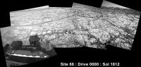
Welcome to Route 66... Er, make that Site 66
 Drive 0000 on Sol 1812. Roughly stitched L-NavCam using MS ICE Midnight Planets reporting it as ~5.6m ESE (115º) link
|
|
 |
 
|
|
 |
|
Jan 23 2018, 11:00 AM
Post
#2
|
|
 Senior Member Group: Members Posts: 1619 Joined: 12-February 06 From: Bergerac - FR Member No.: 678 |
Yeah, I saw the pictures that will coming from Sol 1931. I just hope there will be no Bayered-jpeged compression there
Sol 1942 Navcam pan. A great place ! 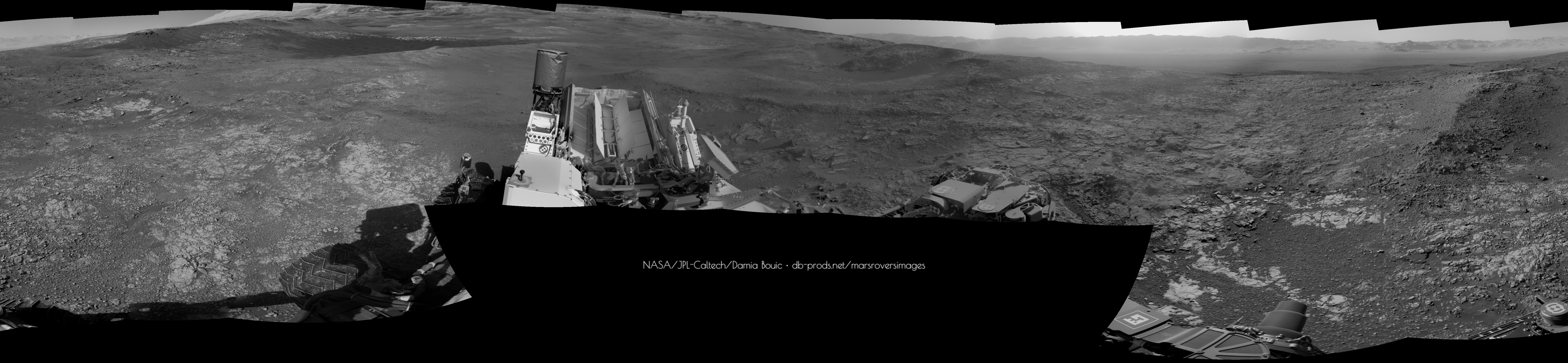
-------------------- |
|
|
|
|
Jan 23 2018, 04:05 PM
Post
#3
|
|
|
Member Group: Members Posts: 122 Joined: 19-June 07 Member No.: 2455 |
So it appears that we're at the highest spot we'll attain until we reach the actual foothills of Mt. Sharp and need to go down into the valley ahead to get to that point. How much elevation are we to lose on that trek down and across before we begin climbing again?
|
|
|
|
 PaulH51 The Top of Vera Rubin Ridge Part 1 Sep 11 2017, 09:50 AM
 Sean Already there Paul!
Hematite & Clay Jan 12 2018, 07:18 AM
Sean Already there Paul!
Hematite & Clay Jan 12 2018, 07:18 AM
 PaulH51 QUOTE (Sean @ Jan 12 2018, 03:18 PM) Alre... Jan 12 2018, 08:50 AM Ant103 Sol 1930 Mastcam34 mosaic of the valley : Jan 12 2018, 12:01 PM PaulH51 I'd have to call this another ring of fine san... Jan 13 2018, 01:45 PM fredk QUOTE (PaulH51 @ Jan 13 2018, 02:45 PM) I... Jan 14 2018, 05:44 AM MrNatural QUOTE (fredk @ Jan 14 2018, 05:44 AM) The... Jan 14 2018, 12:31 PM charborob I wonder if there is a problem with Midnight Plane... Jan 13 2018, 07:28 PM PaulH51 QUOTE (charborob @ Jan 14 2018, 03:28 AM)... Jan 14 2018, 04:04 AM serpens Not sure but this looks more like a ridge than a g... Jan 14 2018, 03:12 PM Phil Stooke "... this looks more like a ridge than a groo... Jan 15 2018, 10:54 PM nogal Phil thank you for the tip about the grains' s... Jan 15 2018, 11:46 PM PaulH51 Many thanks for the clarification re the grain sha... Jan 16 2018, 04:49 AM marsbug If it's any comfort: In close-up my brain insi... Jan 16 2018, 06:30 AM paraisosdelsistemasolar Hope this angle clarifies better than it is a groo... Jan 16 2018, 10:16 AM atomoid one optical illusion down, and the tricks continue... Jan 16 2018, 06:53 PM algorithm I found Wally!!!!
See bottom of t... Jan 16 2018, 07:09 PM Phil Stooke In this image:
http://www.midnightplanets.com/web... Jan 16 2018, 08:51 PM atomoid small off-center clump of twisted-up bristles sol1... Jan 16 2018, 09:46 PM PaulH51 QUOTE (atomoid @ Jan 17 2018, 05:46 AM) .... Jan 17 2018, 07:49 AM serpens The dust removal tool brushes are articulated in t... Jan 17 2018, 09:07 AM Gerald Consider the bristles as compasses. They'll cr... Jan 17 2018, 01:34 PM serpens Indeed, 45mm diameter concentric circles. But the... Jan 17 2018, 10:52 PM Phil Stooke Here's one, not so well developed, from sol 17... Jan 17 2018, 11:45 PM serpens Actually Phil's identification of the central ... Jan 18 2018, 02:18 AM MrNatural QUOTE (serpens @ Jan 18 2018, 02:18 AM) A... Jan 18 2018, 02:59 AM serpens QUOTE (MrNatural @ Jan 18 2018, 02:59 AM)... Jan 21 2018, 09:34 PM PaulH51 Quick and dirty, 1939 bump using MS-ICE with the R... Jan 19 2018, 01:17 PM Phil Stooke Paul's panorama in circular form.
Phil
Jan 19 2018, 11:32 PM Ant103 So ! I've been working since weeks on a pr... Jan 19 2018, 11:56 PM vikingmars QUOTE (Ant103 @ Jan 20 2018, 12:56 AM) So... Jan 20 2018, 11:55 AM Sean Great job Damia, destined to be a classic pano...t... Jan 20 2018, 06:10 AM Phil Stooke Damia, nobody colorizes a Navcam panorama like you... Jan 21 2018, 03:23 AM Ant103 Thank you everyone for all of your kind comments a... Jan 23 2018, 12:10 AM PaulH51 QUOTE (Ant103 @ Jan 23 2018, 08:10 AM) Th... Jan 23 2018, 09:41 AM scalbers Interesting to see how the blended sky looks in Da... Jan 23 2018, 01:04 AM charborob Sol 1942 Lmastcam: Jan 23 2018, 05:03 PM PaulH51 A 'preview crop' from a roughly stitched (... Jan 24 2018, 12:43 AM Sean Sol 1943 MAHLI selfie with extended sky & fore... Jan 24 2018, 09:14 AM Ant103 Great job Sean
And my take on this self-portrait... Jan 24 2018, 11:23 AM Sean Thanks Damia!
Here is a cropped portrait in 4... Jan 24 2018, 01:51 PM Sean An experiment: A wider shot with filled edges, ext... Jan 24 2018, 02:24 PM Phil Stooke Beautiful selfies from everyone! Here is a de... Jan 24 2018, 06:08 PM Kevin Gill Stitched the Sol 1943 self portrait. Did both a ra... Jan 24 2018, 06:22 PM neo56 Here is my take on this sol 1943 self-portrait. I ... Jan 24 2018, 10:29 PM elakdawalla Since we're at nearly 350 posts and it seems l... Jan 25 2018, 02:02 AM James Sorenson A little late in the game, but here is my version ... Jan 26 2018, 12:57 AM Sean So worth the wait! Just beautiful work James. ... Jan 26 2018, 02:32 AM Ant103 It will not be complete without my version
Ter... Jan 26 2018, 12:11 PM Art Martin QUOTE (Ant103 @ Jan 26 2018, 05:11 AM) It... Jan 26 2018, 01:59 PM Ant103 And Sol 1943 self-portrait is full, thanks to new ... Jan 30 2018, 03:14 PM neo56 I completed the MC34 mosaic taken during the first... Jul 1 2018, 02:30 PM Sean New pass on the 1943 selfie now that all the frame... Aug 22 2018, 04:44 PM Sean RoverGlobe Aug 22 2018, 08:39 PM
PaulH51 QUOTE (Sean @ Jan 12 2018, 03:18 PM) Alre... Jan 12 2018, 08:50 AM Ant103 Sol 1930 Mastcam34 mosaic of the valley : Jan 12 2018, 12:01 PM PaulH51 I'd have to call this another ring of fine san... Jan 13 2018, 01:45 PM fredk QUOTE (PaulH51 @ Jan 13 2018, 02:45 PM) I... Jan 14 2018, 05:44 AM MrNatural QUOTE (fredk @ Jan 14 2018, 05:44 AM) The... Jan 14 2018, 12:31 PM charborob I wonder if there is a problem with Midnight Plane... Jan 13 2018, 07:28 PM PaulH51 QUOTE (charborob @ Jan 14 2018, 03:28 AM)... Jan 14 2018, 04:04 AM serpens Not sure but this looks more like a ridge than a g... Jan 14 2018, 03:12 PM Phil Stooke "... this looks more like a ridge than a groo... Jan 15 2018, 10:54 PM nogal Phil thank you for the tip about the grains' s... Jan 15 2018, 11:46 PM PaulH51 Many thanks for the clarification re the grain sha... Jan 16 2018, 04:49 AM marsbug If it's any comfort: In close-up my brain insi... Jan 16 2018, 06:30 AM paraisosdelsistemasolar Hope this angle clarifies better than it is a groo... Jan 16 2018, 10:16 AM atomoid one optical illusion down, and the tricks continue... Jan 16 2018, 06:53 PM algorithm I found Wally!!!!
See bottom of t... Jan 16 2018, 07:09 PM Phil Stooke In this image:
http://www.midnightplanets.com/web... Jan 16 2018, 08:51 PM atomoid small off-center clump of twisted-up bristles sol1... Jan 16 2018, 09:46 PM PaulH51 QUOTE (atomoid @ Jan 17 2018, 05:46 AM) .... Jan 17 2018, 07:49 AM serpens The dust removal tool brushes are articulated in t... Jan 17 2018, 09:07 AM Gerald Consider the bristles as compasses. They'll cr... Jan 17 2018, 01:34 PM serpens Indeed, 45mm diameter concentric circles. But the... Jan 17 2018, 10:52 PM Phil Stooke Here's one, not so well developed, from sol 17... Jan 17 2018, 11:45 PM serpens Actually Phil's identification of the central ... Jan 18 2018, 02:18 AM MrNatural QUOTE (serpens @ Jan 18 2018, 02:18 AM) A... Jan 18 2018, 02:59 AM serpens QUOTE (MrNatural @ Jan 18 2018, 02:59 AM)... Jan 21 2018, 09:34 PM PaulH51 Quick and dirty, 1939 bump using MS-ICE with the R... Jan 19 2018, 01:17 PM Phil Stooke Paul's panorama in circular form.
Phil
Jan 19 2018, 11:32 PM Ant103 So ! I've been working since weeks on a pr... Jan 19 2018, 11:56 PM vikingmars QUOTE (Ant103 @ Jan 20 2018, 12:56 AM) So... Jan 20 2018, 11:55 AM Sean Great job Damia, destined to be a classic pano...t... Jan 20 2018, 06:10 AM Phil Stooke Damia, nobody colorizes a Navcam panorama like you... Jan 21 2018, 03:23 AM Ant103 Thank you everyone for all of your kind comments a... Jan 23 2018, 12:10 AM PaulH51 QUOTE (Ant103 @ Jan 23 2018, 08:10 AM) Th... Jan 23 2018, 09:41 AM scalbers Interesting to see how the blended sky looks in Da... Jan 23 2018, 01:04 AM charborob Sol 1942 Lmastcam: Jan 23 2018, 05:03 PM PaulH51 A 'preview crop' from a roughly stitched (... Jan 24 2018, 12:43 AM Sean Sol 1943 MAHLI selfie with extended sky & fore... Jan 24 2018, 09:14 AM Ant103 Great job Sean
And my take on this self-portrait... Jan 24 2018, 11:23 AM Sean Thanks Damia!
Here is a cropped portrait in 4... Jan 24 2018, 01:51 PM Sean An experiment: A wider shot with filled edges, ext... Jan 24 2018, 02:24 PM Phil Stooke Beautiful selfies from everyone! Here is a de... Jan 24 2018, 06:08 PM Kevin Gill Stitched the Sol 1943 self portrait. Did both a ra... Jan 24 2018, 06:22 PM neo56 Here is my take on this sol 1943 self-portrait. I ... Jan 24 2018, 10:29 PM elakdawalla Since we're at nearly 350 posts and it seems l... Jan 25 2018, 02:02 AM James Sorenson A little late in the game, but here is my version ... Jan 26 2018, 12:57 AM Sean So worth the wait! Just beautiful work James. ... Jan 26 2018, 02:32 AM Ant103 It will not be complete without my version
Ter... Jan 26 2018, 12:11 PM Art Martin QUOTE (Ant103 @ Jan 26 2018, 05:11 AM) It... Jan 26 2018, 01:59 PM Ant103 And Sol 1943 self-portrait is full, thanks to new ... Jan 30 2018, 03:14 PM neo56 I completed the MC34 mosaic taken during the first... Jul 1 2018, 02:30 PM Sean New pass on the 1943 selfie now that all the frame... Aug 22 2018, 04:44 PM Sean RoverGlobe Aug 22 2018, 08:39 PM |

|
Lo-Fi Version | Time is now: 24th May 2024 - 02:14 AM |
|
RULES AND GUIDELINES Please read the Forum Rules and Guidelines before posting. IMAGE COPYRIGHT |
OPINIONS AND MODERATION Opinions expressed on UnmannedSpaceflight.com are those of the individual posters and do not necessarily reflect the opinions of UnmannedSpaceflight.com or The Planetary Society. The all-volunteer UnmannedSpaceflight.com moderation team is wholly independent of The Planetary Society. The Planetary Society has no influence over decisions made by the UnmannedSpaceflight.com moderators. |
SUPPORT THE FORUM Unmannedspaceflight.com is funded by the Planetary Society. Please consider supporting our work and many other projects by donating to the Society or becoming a member. |
|