It's June - Better LOLA? |

  |
It's June - Better LOLA? |
 Sep 10 2010, 12:32 AM Sep 10 2010, 12:32 AM
Post
#31
|
|
|
Member  Group: Members Posts: 890 Joined: 18-November 08 Member No.: 4489 |
just took a look at
http://imbrium.mit.edu/DATA/LOLA_GDR/ the img's have a sep3 date PS. for the count files( CDEM_ ) pds2isis tosses en error about the " SAMPLE_BITS = 2" - isis wants 8 ,16 ,or 32 small edit in the LBL solves this as per Rick Sternbach question there is a MAC isis3 and for just using pds2isis then > isis2raw most of the data dose not need to be installed just the BASE system ( small install ) and some of the data files CODE rsync -azv --delete isisdist.wr.usgs.gov::x86_darwin_OSX105/isis . rsync -azv --delete isisdist.wr.usgs.gov::isis3data/data/base data/ but you can remove the very large maps if space is an issue /isis_3/data/base/dems ~4.8 gig |
 |
 
|
|
Sep 10 2010, 06:30 AM
Post
#32
|
|
|
Junior Member Group: Members Posts: 23 Joined: 6-November 09 Member No.: 5017 |
QUOTE (JohnVV @ Sep 9 2010, 05:32 PM)  as per Rick Sternbach question there is a MAC isis3 Thanks; I looked into ISIS some time ago. Way, way, way over my head. - R. |
|
|
|
|
Sep 10 2010, 06:50 AM
Post
#33
|
|
|
Newbie Group: Members Posts: 8 Joined: 20-April 05 Member No.: 276 |
QUOTE (JohnVV @ Sep 10 2010, 02:32 AM) Nice! From the label LDEM_64.IMG is updated with observation up to June 27 and there is a new LDEM_128.IMG to play with 
|
|
|
|
|
Sep 10 2010, 07:08 AM
Post
#34
|
|
|
Member Group: Members Posts: 890 Joined: 18-November 08 Member No.: 4489 |
i just imported the 128 into Nip2 and did a simple "emboss " filter
two screenshots from nip 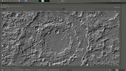 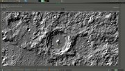 the second is zoomed in a bit still need some work but better than the last set give it a year and it will rival the MOLA |
|
|
|
|
Sep 10 2010, 10:28 PM
Post
#35
|
|
|
Member Group: Members Posts: 890 Joined: 18-November 08 Member No.: 4489 |
Rick Sternbach and a few others i can post the 128 as a 2 gig raw image
500 meg north west,south west,north east , and south east with 0 long and 0 lat in the center of the map ( -180 to 180) --- rant --- raw2isis has a bug, that i am about to report -- i would but the USGS is down for maintenance 16 bit unsigned ( my working format) gets saved as 32 bit REAL but the cubs say they are 16unsigned -- just a bit of an issue and pds2isis is doing it too map2map is a MESS. telling isis it is 16 bit signed ( from the cube& img )when it is 32 bit float ( the data in the cube) at least isis2raw IS WORKING the way it should i have finally a 90north to 40 north ( polar), the same for the south pole and 45n to 45s ( simple cylindrical ) so i can clean them up a bit |
|
|
|
|
Sep 11 2010, 04:14 PM
Post
#36
|
|
|
Junior Member Group: Members Posts: 23 Joined: 6-November 09 Member No.: 5017 |
QUOTE (JohnVV @ Sep 10 2010, 03:28 PM) Rick Sternbach and a few others i can post the 128 as a 2 gig raw image 500 meg north west,south west,north east , and south east with 0 long and 0 lat in the center of the map ( -180 to 180) John - That's a generous offer; thanks. Even the individual 500MB tiles would be fine in my case, as I'd be exploring smaller areas in Terragen or TG2. Eventually for rapid prototyping a physical globe, I'd be getting with the smart folks who have the computing horsepower to work with the .img files and grow the resin parts, but right now I'm hoping to "look around" the surface in 3D. - Rick |
|
|
|
|
Sep 11 2010, 06:23 PM
Post
#37
|
|
|
Senior Member Group: Members Posts: 1075 Joined: 21-September 07 From: Québec, Canada Member No.: 3908 |
QUOTE (Rick Sternbach @ Sep 11 2010, 11:14 AM) I'm hoping to "look around" the surface in 3D. I'd like to see what results you obtain with Terragen. Post some of your picture when you have them. |
|
|
|
|
Sep 11 2010, 08:16 PM
Post
#38
|
|
|
Member Group: Members Posts: 890 Joined: 18-November 08 Member No.: 4489 |
i will post links to them later on tonight ( i have to export them )
|
|
|
|
|
Sep 12 2010, 01:03 AM
Post
#39
|
|
|
Junior Member Group: Members Posts: 22 Joined: 20-June 09 Member No.: 4830 |
QUOTE (Rick Sternbach @ Sep 9 2010, 07:31 PM) Oh, and I just noticed a lot of file names *missing*, like all the JPG2000 files. With my limited Mac software here, those were the only files I could get to look at and use in Terragen. I can get a file like LDEM_64.img to open in MacDEM as I did with the MOLA files, but now MacDEM can't figure out the height range (I think). Image comes out where I can see the terrain with directional lighting turned on, but the shades are all super contrasty and black-white splotchy. Probably time to get a new machine and better terrain software.  GeoJPEG2000 are forthcoming. We want to make sure they're correct, and we found some strange things happening with the programs used to make the conversion. Anyway, release date has always been the 15th, if you can wait that long  As for the 128ppd being too large, we did not plan on splitting those up, but that could potentially be done in the next release, if enough people think it's worthwhile. The problem is that when we eventually release a 1024ppd, we don't want to break them up 256 tiles (each equivalent to a 64ppd global). 64 "128ppd" tiles will be quite enough already! Erwan |
|
|
|
|
Sep 12 2010, 03:08 AM
Post
#40
|
|
|
Member Group: Members Posts: 890 Joined: 18-November 08 Member No.: 4489 |
As for the 128ppd being too large,
not for me but to upload a zip to a service like zshare , they need to be small so there is a plan to release a 368640 x 184320 pixel image 68 megapixle map ( 1024 px per deg. ) |
|
|
|
|
Sep 12 2010, 01:37 PM
Post
#41
|
|
 Senior Member Group: Moderator Posts: 3431 Joined: 11-August 04 From: USA Member No.: 98 |
Looking forward to the new RDRs. Thanks.
|
|
|
|
|
Sep 16 2010, 04:54 AM
Post
#42
|
||
|
Junior Member Group: Members Posts: 23 Joined: 6-November 09 Member No.: 5017 |
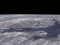
QUOTE (zeBeamer @ Sep 11 2010, 06:03 PM) GeoJPEG2000 are forthcoming. We want to make sure they're correct, and we found some strange things happening with the programs used to make the conversion. Anyway, release date has always been the 15th, if you can wait that long As for the 128ppd being too large, we did not plan on splitting those up, but that could potentially be done in the next release, if enough people think it's worthwhile. The problem is that when we eventually release a 1024ppd, we don't want to break them up 256 tiles (each equivalent to a 64ppd global). 64 "128ppd" tiles will be quite enough already! Erwan I see the new LDEM files with the "PPD" stuck in the middle, and I can open the 4, 16, and 64 JP2000 versions, but no way can I get the 128 to open in Photoshop, even with almost 1GB RAM devoted to the application and a healthy secondary HD. I get a message talking about trouble with a "file-interface module," which I have no idea how to fix. As before, I suspect I'd need a Mac Pro with 8GB of RAM to play in the bigger sandbox. Anyhow, I'm attaching a view of Copernicus from the 64 file, quick render in Terragen. - Rick
Attached thumbnail(s)
|
|
|
|
|
|
|
Nov 25 2010, 08:26 PM
Post
#43
|
|
|
Junior Member Group: Members Posts: 37 Joined: 26-January 10 From: Reading, UK Member No.: 5192 |
How are you guys processing the RDRs? I have found RDR2TAB and RDR2XYZ but they are for MAC only, has anyone found a win32 version? I have the fortran source code but no compiler.
Thanks for any help. |
|
|
|
|
Nov 25 2010, 10:11 PM
Post
#44
|
|
|
Member Group: Members Posts: 890 Joined: 18-November 08 Member No.: 4489 |
QUOTE How are you guys processing the RDRs? I have found RDR2TAB and RDR2XYZ they take way to much work at this time I use the GDR pds IMG files http://imbrium.mit.edu/DATA/LOLA_GDR/ |
|
|
|
|
Nov 26 2010, 04:45 AM
Post
#45
|
|
|
Senior Member Group: Moderator Posts: 3431 Joined: 11-August 04 From: USA Member No.: 98 |
QUOTE (Mars3D @ Nov 25 2010, 02:26 PM) How are you guys processing the RDRs? I'm using custom software to do it - on Mac, so can't really help there. Yes, most people are using the GDRs. |
|
|
|
|

|
Lo-Fi Version | Time is now: 22nd September 2024 - 04:15 AM |
|
RULES AND GUIDELINES Please read the Forum Rules and Guidelines before posting. IMAGE COPYRIGHT |
OPINIONS AND MODERATION Opinions expressed on UnmannedSpaceflight.com are those of the individual posters and do not necessarily reflect the opinions of UnmannedSpaceflight.com or The Planetary Society. The all-volunteer UnmannedSpaceflight.com moderation team is wholly independent of The Planetary Society. The Planetary Society has no influence over decisions made by the UnmannedSpaceflight.com moderators. |
SUPPORT THE FORUM Unmannedspaceflight.com is funded by the Planetary Society. Please consider supporting our work and many other projects by donating to the Society or becoming a member. |
|