Whole Earth images, Does any satellite provide regularly updated ones? |

  |
Whole Earth images, Does any satellite provide regularly updated ones? |
 Sep 16 2010, 10:39 PM Sep 16 2010, 10:39 PM
Post
#151
|
||
 Senior Member  Group: Members Posts: 3648 Joined: 1-October 05 From: Croatia Member No.: 523 |
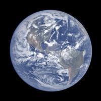
Here's a colorization of this LRO Earth image. Below is a preview at 10% resolution, 1/2 res version is available here (2.3 MB) and full res version here (8 MB).
-------------------- |
|
 |
 
|
|
|
Sep 16 2010, 11:04 PM
Post
#152
|
|
|
Senior Member Group: Members Posts: 2922 Joined: 14-February 06 From: Very close to the Pyrénées Mountains (France) Member No.: 682 |
The full version is extremely impressive! I can see clearly where I'm at the moment with some details, lake Chungara south East of Lake Titicaca.
-------------------- |
|
|
|
|
Oct 23 2010, 03:24 AM
Post
#153
|
|
|
Newbie Group: Members Posts: 2 Joined: 21-October 10 Member No.: 5499 |
The earth's image is awesome. Wow! The earth's is beautiful to look at a distant.
-------------------- Save Energy|Generate Solar Power For Homes with Homemade Solar Panels
|
|
|
|
|
Mar 31 2011, 05:32 AM
Post
#154
|
|
|
Senior Member Group: Members Posts: 1585 Joined: 14-October 05 From: Vermont Member No.: 530 |
Interesting post on gizmodo about data coming from a Russian weather satellite:
http://gizmodo.com/#!5787176/this-is-t...een-them-before |
|
|
|
|
Apr 21 2011, 07:21 PM
Post
#155
|
|
 The Poet Dude Group: Moderator Posts: 5551 Joined: 15-March 04 From: Kendal, Cumbria, UK Member No.: 60 |
Whole Earth images - but from long, long ago..
https://sites.google.com/a/upr.edu/planetar.../library/vpe-pr VERY cool 
-------------------- |
|
|
|
|
Apr 21 2011, 07:24 PM
Post
#156
|
|
 Administrator Group: Admin Posts: 5172 Joined: 4-August 05 From: Pasadena, CA, USA, Earth Member No.: 454 |
Agreed, those are awesome!
-------------------- My website - My Patreon - @elakdawalla on Twitter - Please support unmannedspaceflight.com by donating here.
|
|
|
|
|
Apr 21 2011, 07:33 PM
Post
#157
|
|
|
The Poet Dude Group: Moderator Posts: 5551 Joined: 15-March 04 From: Kendal, Cumbria, UK Member No.: 60 |
I am so going to make a gif animation of those three maps, for use in my Outreach talks!

-------------------- |
|
|
|
|
Apr 21 2011, 09:05 PM
Post
#158
|
|
 Senior Member Group: Moderator Posts: 2785 Joined: 10-November 06 From: Pasadena, CA Member No.: 1345 |
Hey Stu, check out this animation (from Early Precambrian to present):
http://en.wikipedia.org/wiki/File:Tectonic...tionGlobal2.gif -------------------- Some higher resolution images available at my photostream: http://www.flickr.com/photos/31678681@N07/
|
|
|
|
|
Apr 21 2011, 10:07 PM
Post
#159
|
|
|
Merciless Robot Group: Admin Posts: 8784 Joined: 8-December 05 From: Los Angeles Member No.: 602 |
Very cool as well, Mike! However, I think that the last image in the animation is probably of the end of the last ice age or so; the Red Sea is much larger, and it looks like the central Asian seas are still merged together.
-------------------- A few will take this knowledge and use this power of a dream realized as a force for change, an impetus for further discovery to make less ancient dreams real.
|
|
|
|
|
Apr 22 2011, 12:25 AM
Post
#160
|
|
|
Senior Member Group: Moderator Posts: 2785 Joined: 10-November 06 From: Pasadena, CA Member No.: 1345 |
Good catch! It is indeed the Neogene-Miocene period as the last step in the animated gif. The work that Stu originally referred to was done in collaboration by Dr. Ron Blakely of Northern Arizona University. (The animations in the wikipedia entry were done by Dr. Ron Blakely.)
Here is his website that has individual maps of each of the paleo-reconstructions (including Pleistocene and Present) : http://jan.ucc.nau.edu/~rcb7/mollglobe.html And a website to other detailed data products: http://cpgeosystems.com/index.html I recently got a copy of his (beautifully illustrated) book: "Ancient Landscapes of the Colorado Plateau", mentioned on his site. I highly recommend it. -------------------- Some higher resolution images available at my photostream: http://www.flickr.com/photos/31678681@N07/
|
|
|
|
|
Jun 14 2011, 02:55 AM
Post
#161
|
||
|
Senior Member Group: Moderator Posts: 2785 Joined: 10-November 06 From: Pasadena, CA Member No.: 1345 |
Animation created from simultaneous views of Earth from five geosynchronous weather satellites taken every six hours starting on March 21, 2011:
[animated GIF: click to animate] -------------------- Some higher resolution images available at my photostream: http://www.flickr.com/photos/31678681@N07/
|
|
|
|
|
|
|
Jun 14 2011, 11:20 AM
Post
#162
|
|
 Newbie Group: Members Posts: 6 Joined: 1-December 09 From: Budapest, Hungary Member No.: 5073 |
A few more images of Elektro-L, the Russian geostationary weather satellite can be found here (among others, like Resurs-DK and Meteor-M):
http://eng.ntsomz.ru/news/news_center |
|
|
|
|
Aug 13 2011, 02:26 PM
Post
#163
|
||
|
Senior Member Group: Members Posts: 3648 Joined: 1-October 05 From: Croatia Member No.: 523 |
Chandrayaan-1 view of the Earth during the solar eclipse of July 22nd, 2009 revisited. Very noisy, 4 visible channels of M3 centered at 620, 580, 540 and 500 nm were processed into this approximately natural color view. The 460 nm channel was useless. The way the M3 instrument scanned, the resolution in the vertical axis is much higher than horizontal.
-------------------- |
|
|
|
|
|
|
Aug 13 2011, 02:43 PM
Post
#164
|
|
|
Administrator Group: Admin Posts: 5172 Joined: 4-August 05 From: Pasadena, CA, USA, Earth Member No.: 454 |
Wow, really cool. There is a ghost image of Earth about three diameters to the right of the actual image -- do you know what causes that?
-------------------- My website - My Patreon - @elakdawalla on Twitter - Please support unmannedspaceflight.com by donating here.
|
|
|
|
|
Aug 13 2011, 02:53 PM
Post
#165
|
|
|
Senior Member Group: Members Posts: 3648 Joined: 1-October 05 From: Croatia Member No.: 523 |
There's a whole bunch of artifacts visible there. Don't know about that specific ghost, I would assume this is optics related. I noticed imaging spectrometers of this type (pushbroom), VIMS visual channel included have subtantial stray light leakage both in the vertical and especially horizontal direction. You can notice the hot pixel columns get brighter left and right of a bright object. I deliberately left all this crud in to make it clear the other non-removable artifacts, such as vertical discolorations on Earth's disc are in fact artifacts and not real.
I should point out this was done using the raw data, of all the M3 images there are archived this one was not provided in a calibrated form. Perhaps because it was a one-off observation. I had to do manual bias subtraction and rudimentary "I/F" conversion. The whole M3 swath actually included another Earth image higher up, vertically flipped. I presume it was taken when the s/c was slewing back and judging by Earth's rotation it was taken a couple of minutes later. I can post a flickr gif of the two, but it's nothing spectacular. -------------------- |
|
|
|
|

|
Lo-Fi Version | Time is now: 5th June 2024 - 06:03 AM |
|
RULES AND GUIDELINES Please read the Forum Rules and Guidelines before posting. IMAGE COPYRIGHT |
OPINIONS AND MODERATION Opinions expressed on UnmannedSpaceflight.com are those of the individual posters and do not necessarily reflect the opinions of UnmannedSpaceflight.com or The Planetary Society. The all-volunteer UnmannedSpaceflight.com moderation team is wholly independent of The Planetary Society. The Planetary Society has no influence over decisions made by the UnmannedSpaceflight.com moderators. |
SUPPORT THE FORUM Unmannedspaceflight.com is funded by the Planetary Society. Please consider supporting our work and many other projects by donating to the Society or becoming a member. |
|