Continuing into Glenelg, Leaving Rocknest behind, sols 102-166 (Nov 18 2012-Jan 23, 2013) |

  |
Continuing into Glenelg, Leaving Rocknest behind, sols 102-166 (Nov 18 2012-Jan 23, 2013) |
 Jan 25 2013, 09:34 PM Jan 25 2013, 09:34 PM
Post
#886
|
||
 Member  Group: Members Posts: 219 Joined: 14-November 11 From: Washington, DC Member No.: 6237 |
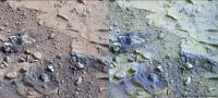
Sol164 MR632 filter image of crunched area in John Klein, next to band-stretched visible light image of the same spot.
Makes me curious... although the rock interiors and the stirred up regolith don't look all that similar in the visible light images they both appear very blue in this image. I think this indicates that they have similarly low reflectance of the NIR bands compared to the surface dust. I guess it would make sense that the subsurface sandy material has similar properties to what could be its parent rock via erosion? Anything else that can be learned (or taught to amateurs like me) from comparing these various materials appearance in different bands? |
|
 |
 
|
|
|
Jan 27 2013, 01:10 PM
Post
#887
|
||
 The Poet Dude Group: Moderator Posts: 5551 Joined: 15-March 04 From: Kendal, Cumbria, UK Member No.: 60 |
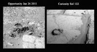
If anyone pointed this out already I apologise, but I was trawling through some old Oppy folders in preparation for a new talk, and I spotted an image that rang a bell. An intriguing feature imaged by Oppy on Jan 26 last year suddenly looked very familiar...
Anyone else see a similarity there..? -------------------- |
|
|
|
|
|
|
Jan 27 2013, 03:02 PM
Post
#888
|
|
 Member Group: Members Posts: 701 Joined: 3-December 04 From: Boulder, Colorado, USA Member No.: 117 |
QUOTE (Stu @ Jan 27 2013, 06:10 AM)  Anyone else see a similarity there..? Definitely a similarity, but it might be a superficial one- the "ring" in the Curiosity image is clearly embedded in bedrock, while the rocks in the Oppy image could be randomly-arranged loose rocks (perhaps the eroded remains of a single rock) that happen to make a ring. John |
|
|
|
|
Jan 29 2013, 04:33 AM
Post
#889
|
|
 Administrator Group: Admin Posts: 5172 Joined: 4-August 05 From: Pasadena, CA, USA, Earth Member No.: 454 |
They incremented the site counter to 6 upon arrival at John Klein on sol 166, so I deem that a good spot to break and start a new thread. Pre-166 discussion continues here, John Klein arm work continues there.
-------------------- My website - My Patreon - @elakdawalla on Twitter - Please support unmannedspaceflight.com by donating here.
|
|
|
|
|
Jan 30 2013, 06:56 AM
Post
#890
|
|
 Senior Member Group: Members Posts: 2228 Joined: 1-December 04 From: Marble Falls, Texas, USA Member No.: 116 |
This is just a late comment regarding the Snake River feature that was discussed a while ago. I don't recall anyone making this suggestion regarding its origin, but I wondered what people thought of the idea that it might be a clastic dike. The overall color seems rather similar to the surrounding sediments.
For non-geologists, a clastic dike is a fracture in rocks that has been filled by an injection of fluidized sediment trying to escape to a region of lower pressure. On Earth clastic dikes have been observed to form in areas where large amounts of sediment have been rapidly deposited, creating places where water saturated sediments have been over pressured. In this scenario we are talking about the weight of the overburden increasing the fluid pressure in buried sediments, causing the local fluid pressure to exceed the hydrostatic pressure. Hydrostatic pressure is simply the pressure in a column of water at said depth. It seems to me that the fluid in these rocks would have had multiple opportunities to have been ovepressured so many billions of years ago, when they formed. We have here a large pile of sediments filling a basin on ancient Mars. Major impacts at the time would have sent large shock waves through the crust, encouraging the de-watering of such water bearing sediments. If that wasn't enough, the slow dessication of Mars from the outside in could have also resulted in overpressured fluid at depth. ...maybe -------------------- ...Tom
I'm not a Space Fan, I'm a Space Exploration Enthusiast. |
|
|
|
|
Jan 30 2013, 08:45 AM
Post
#891
|
|
|
Senior Member Group: Members Posts: 3516 Joined: 4-November 05 From: North Wales Member No.: 542 |
That seems like an excellent suggestion to me.
|
|
|
|
|
Jan 30 2013, 04:09 PM
Post
#892
|
|
 Senior Member Group: Members Posts: 3419 Joined: 9-February 04 From: Minneapolis, MN, USA Member No.: 15 |
Quite excellent suggestion, Tom. Especially when you consider that Mars' atmosphere was losing pressure over the first billion years or so of the planet's evolution. Groundwater would become overpressured over time because of the lowering atmospheric pressure, and while our elegant equations can show the average loss of groundwater due to this increasing pressure gradient, we all know that the actual process takes place in bursts interspersed with periods of quietude.
I can imagine a situation where a groundwater reservoir is trapped by its enclosing rock beds, and some outside force (impact or other breaking or tearing force) creates a vent from the reservoir to the lower-pressured surface environment. A small vent would pull water up out of the reservoir over time, which would be pulled through cracks on the upside of the main crack(s) venting the reservoir. Thus forming clastic dikes. The concept certainly has an aura of truthfulness to it. -the other Doug -------------------- The trouble ain't that there is too many fools, but that the lightning ain't distributed right. -Mark Twain
|
|
|
|
|
Jan 30 2013, 07:56 PM
Post
#893
|
|
|
Senior Member Group: Members Posts: 3516 Joined: 4-November 05 From: North Wales Member No.: 542 |
And the idea finds itself in good company today
 : http://www.sciencedaily.com/releases/2013/...30129121941.htm : http://www.sciencedaily.com/releases/2013/...30129121941.htm
|
|
|
|
|
Jan 31 2013, 10:23 PM
Post
#894
|
|
|
Senior Member Group: Members Posts: 1045 Joined: 17-February 09 Member No.: 4605 |
QUOTE (CosmicRocker @ Jan 30 2013, 06:56 AM) ... I wondered what people thought of the idea that it might be a clastic dike. ..... Major impacts at the time would have sent large shock waves through the crust, encouraging the de-watering of such water bearing sediments. If that wasn't enough, the slow dessication of Mars from the outside in could have also resulted in overpressured fluid at depth. Parroting the other Doug's words, a quite excellent suggestion, Tom. My only reservation is with respect to the injection mechanism. Rather than a pressure driven dewatering structure would a diapir effect be an acceptable alternative hypothesis? This could correlate to those open/closed mounds we bypassed on the way in. Underlying sediment rising through a density difference. |
|
|
|
|
Jan 31 2013, 11:26 PM
Post
#895
|
|
 Member Group: Members Posts: 714 Joined: 3-January 08 Member No.: 3995 |
.
|
|
|
|
|
Feb 1 2013, 04:51 AM
Post
#896
|
|
|
Senior Member Group: Members Posts: 2228 Joined: 1-December 04 From: Marble Falls, Texas, USA Member No.: 116 |
Thanks for the votes of confidence on the hypothesis. Hopefully it won't be long before we get a data release which may shed some light on things. Now, you guys have gotten me thinking about the surface of a freezing, desiccating planet. Ablation, deflation, compaction?
................. I'm so glad somebody invented the other planets. ................. serpens: Can you give us a little more detail regarding how a diapiric process might have acted on Mars to create a clastic dike? I can imagine a diapir creating an over-pressured region, but what is the origin of your density gradient? Are you suggesting a layer of salt beneath these rocks? ...or ice? I'm not sure which mounds you are referring to. Can you post a link or two? Gladstoner: Thanks for posting that image. I think I have one somewhere, but it is probably forever lost on a 35 mm slide... -------------------- ...Tom
I'm not a Space Fan, I'm a Space Exploration Enthusiast. |
|
|
|
|
Feb 1 2013, 09:52 PM
Post
#897
|
|
|
Member Group: Members Posts: 384 Joined: 4-January 07 Member No.: 1555 |
To ablation, deflation, and compaction on a freezing, dessicating planet, don't forget to add impact (blast) effects. Regarding the rocks possibly produced, e.g., at Meridiani (MER2), Home Plate (MER1), and now Shaler (MSL), note this LPSC abstract out today:
http://www.lpi.usra.edu/meetings/lpsc2013/pdf/1004.pdf. For once, I am NOT an author. In this regard, the Shaler blast beds, if that's what they are, appear to be sitting on top of everything else (just as they are at Home Plate and Meridiani) and their origin could therefore be completely independent of that of the older "muddy"rocks beneath, such as those currently under discussion. For a more conventional (terra-centric) fluvial origin for Shaler, note this LPSC abstract: http://www.lpi.usra.edu/meetings/lpsc2013/pdf/1628.pdf. Just FYI, without discussion (please). Now back to your regular programming. - dburt |
|
|
|
|
Feb 1 2013, 10:55 PM
Post
#898
|
|
|
Senior Member Group: Members Posts: 1045 Joined: 17-February 09 Member No.: 4605 |
I wasnt thinking either ice or salt Tom. More along the lines of a watery mud/silt overlayed by a thick layer of coarser sand. In an unconsolidated soft sediment environment the density difference would allow the mud/silt to move upward with local differences in density enabling mud/silt segments to detach and rise, tending to form into spheres, breaching the surface. If rinds then formed this would later result in differential erosion leaving this:
http://mars.jpl.nasa.gov/msl-raw-images/ms...0000E2_DXXX.jpg We saw smaller examples where un-eroded domes were evident at the surface. If the surface began to dry out forming dessication cracks then towards the end of the process the rising mud/silt would fill these causing the narrow dyke under discussion. If compaction/load was the cause then I guess we would expect flame structures,. Ditto if the cause was dewatering due to shock loading where dewatering pipes and pillar structures would be evident. But in lack of crater road cuts how can we tell? Regardless of the mechanism, I think you are spot on. |
|
|
|
|
Feb 2 2013, 03:38 AM
Post
#899
|
|
|
Senior Member Group: Members Posts: 2998 Joined: 30-October 04 Member No.: 105 |
Wish list for MSL2: cat scan table for "digital thin sections".
Alien processes. Though I do favor the "dewatering via vibration" process. RE: the LPSC paper cited: is NG Barlow a colleague of yours? All in all, this LPSC is going to be very good! --Bill -------------------- |
|
|
|
|
Feb 2 2013, 03:49 AM
Post
#900
|
|
|
Senior Member Group: Members Posts: 2998 Joined: 30-October 04 Member No.: 105 |
QUOTE (ngunn @ Jan 30 2013, 02:56 PM) And the idea finds itself in good company today To cite other investigations on Mars, recall the Anatolia Features at Meridiani and the "gypsum" fracture-fills at Endeavour (MER-A) and the lineations in the Homeplate Hollow (MER- : http://www.sciencedaily.com/releases/2013/...30129121941.htm . .--Bill -------------------- |
|
|
|
|

|
Lo-Fi Version | Time is now: 5th June 2024 - 12:57 AM |
|
RULES AND GUIDELINES Please read the Forum Rules and Guidelines before posting. IMAGE COPYRIGHT |
OPINIONS AND MODERATION Opinions expressed on UnmannedSpaceflight.com are those of the individual posters and do not necessarily reflect the opinions of UnmannedSpaceflight.com or The Planetary Society. The all-volunteer UnmannedSpaceflight.com moderation team is wholly independent of The Planetary Society. The Planetary Society has no influence over decisions made by the UnmannedSpaceflight.com moderators. |
SUPPORT THE FORUM Unmannedspaceflight.com is funded by the Planetary Society. Please consider supporting our work and many other projects by donating to the Society or becoming a member. |
|