Apollo Sites from LRO |

  |
Apollo Sites from LRO |
 May 8 2012, 01:47 PM May 8 2012, 01:47 PM
Post
#376
|
|
|
Junior Member  Group: Members Posts: 62 Joined: 30-July 09 Member No.: 4887 |
Apollo Lunar Surface Journal on Apollo Flags as seen by LRO.
This link is to this page: Apollo Lunar Surface Journal Apollo Flags Link |
 |
 
|
|
May 8 2012, 11:10 PM
Post
#377
|
|
 Member Group: Members Posts: 796 Joined: 27-February 08 From: Heart of Europe Member No.: 4057 |
Interesting animated gifs!
Evidently I didn't see all LRO's images of Apollo sites, because I recognized only few frames. -------------------- |
|
|
|
|
May 10 2012, 04:52 PM
Post
#378
|
|
|
Senior Member Group: Members Posts: 1592 Joined: 14-October 05 From: Vermont Member No.: 530 |
For what it's worth, you have to take the idea that "UV light will surely destroy the nylon" with a grain of salt-- I've never seen anyone say for certain whether UV light can destroy nylon in a vacuum.
|
|
|
|
|
May 11 2012, 02:46 PM
Post
#379
|
|
|
Junior Member Group: Members Posts: 61 Joined: 20-March 10 From: Western Australia Member No.: 5275 |
Good call. Many of the corrosive forces that take place on the surface of the Earth, rely on oxidation. Degradation by UV is a form of sloww cooking.
Lets say the flags have survived? That can be a big plus for future Moon exploration. We could use 'plastic' habitats and machines and be confident that they can survive the harsh Lunar enviroment. Gotta take a closer look! |
|
|
|
|
Jul 25 2015, 08:11 AM
Post
#380
|
|
 Member Group: Members Posts: 238 Joined: 15-January 13 Member No.: 6842 |
A very cool and informative way to view Apollo sites at different times of the lunar day is to use the "flip book", like this one for Apollo 17: http://www.lroc.asu.edu/featured_sites/view_site/6
You can see the shadows from various hardware (including the flags) grow of shrink depending on sun angle. As the shadow from the flags is clearly hovering above ground level, this shows that the flags are still up on their flagpoles. -------------------- Curiosity rover panoramas: http://www.facebook.com/CuriosityRoverPanoramas
My Photosynth panoramas: http://photosynth.net/userprofilepage.aspx...;content=Synths |
|
|
|
|
May 21 2016, 12:03 AM
Post
#381
|
|||
|
Solar System Cartographer Group: Members Posts: 10227 Joined: 5-April 05 From: Canada Member No.: 227 |
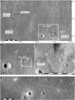
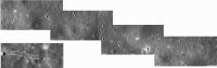
One of the puzzles about LRO imaging of Apollo sites has been the lack of evidence for the LM Ascent Stage impacts. Like many people, I have searched for them without success. But I have just observed something curious very close to the expected location of the Apollo 12 LMAS. I have attached two images. One 'zooms in' to the expected impact area and shows an ellipse where the impact was thought to have occurred. That ellipse contains a fantastic crater which would be marvellous candidate except that it clearly exists in a Lunar Orbiter image taken before Apollo. But I have just noted that on the west end of the ellipse is a curious area of small dark streaks, looking like some of the distal ejecta splotches the LRO team has reported around very recent impacts. Except -they don't form a radial pattern and only occur in a linear band oriented pretty much as the LM was travelling. My second image shows the area of this observation - just screen grabs from Quickmap at this stage.
It would be really nice if this could be traced back to some kind of surface disturbance - even if not a very obvious crater. But I don't see anything of the sort. Impossible to be sure of anything, but I thought I would point it out. It would be interesting to see if similar features occur at other LMAS locations. Phil
-------------------- ... because the Solar System ain't gonna map itself.
Also to be found posting similar content on https://mastodon.social/@PhilStooke Maps for download (free PDF: https://upload.wikimedia.org/wikipedia/comm...Cartography.pdf NOTE: everything created by me which I post on UMSF is considered to be in the public domain (NOT CC, public domain) |
||
|
|
|
||
|
May 21 2016, 08:37 AM
Post
#382
|
|
|
Merciless Robot Group: Admin Posts: 8785 Joined: 8-December 05 From: Los Angeles Member No.: 602 |
Newbie questions: With respect to the image orientation, from which direction was the ascent stage expected to come in from? I'm assuming from the right side.
Also, were they intentionally deorbited in any way, or were they completely uncontrolled? Reason I ask is that if they were just allowed to decay then a grazing impact seems possible. Maybe the hardware got widely distributed along the track instead of forming a nice neat crater given the overall fragility of the vehicle. Probably the only thing that could be expected to survive is the engine. -------------------- A few will take this knowledge and use this power of a dream realized as a force for change, an impetus for further discovery to make less ancient dreams real.
|
|
|
|
|
May 21 2016, 04:24 PM
Post
#383
|
|
|
Solar System Cartographer Group: Members Posts: 10227 Joined: 5-April 05 From: Canada Member No.: 227 |
You're a newbie?
The spacecraft approached from the east - all Apollo missions orbited east to west (the Lunar Orbiters orbited west to east). Apollo 12 was commanded to impact, but still a grazing impact. Apollo 11 and 16 were not commanded and fell at unknown locations. Apollos 12, 14, 15 and 17 were commanded to impact. None of the crashed LM ascent stages have been associated with any impact crater yet. Phil -------------------- ... because the Solar System ain't gonna map itself.
Also to be found posting similar content on https://mastodon.social/@PhilStooke Maps for download (free PDF: https://upload.wikimedia.org/wikipedia/comm...Cartography.pdf NOTE: everything created by me which I post on UMSF is considered to be in the public domain (NOT CC, public domain) |
|
|
|
|
May 21 2016, 10:55 PM
Post
#384
|
|
 Senior Member Group: Members Posts: 3419 Joined: 9-February 04 From: Minneapolis, MN, USA Member No.: 15 |
All of the LM ascent stages were grazing impacts, but all of them caused rather strong seismic signals, picked up quite clearly and distinctly even by seismometers emplaced hundreds of kilometers away. The fact that the A16 LM ascent stage impact wasn't noted on any of the seismometers I always put down to the likelihood that it impacted on the far side, with most of the Moon's bulk between it and the seismometers.
You would have to think that anything that generated such seismic signals would have created a crater, wouldn't you? It also seems to me that the dark streaks seem radial. If you ran lines back along the streaks, wouldn't that point you back to the origin point of all of them? There couldn't have been a lot of interactions that would have sent off debris on non-radial trajectories, so most of the streaks ought to point directly back to the impact point, right? -------------------- The trouble ain't that there is too many fools, but that the lightning ain't distributed right. -Mark Twain
|
|
|
|
|
May 22 2016, 09:53 PM
Post
#385
|
|
|
Solar System Cartographer Group: Members Posts: 10227 Joined: 5-April 05 From: Canada Member No.: 227 |
"If you ran lines back along the streaks, wouldn't that point you back to the origin point of all of them? There couldn't have been a lot of interactions that would have sent off debris on non-radial trajectories, so most of the streaks ought to point directly back to the impact point, right?"
If only I had thought of that! Actually - I did: "It would be really nice if this could be traced back to some kind of surface disturbance - even if not a very obvious crater. But I don't see anything of the sort." Phil -------------------- ... because the Solar System ain't gonna map itself.
Also to be found posting similar content on https://mastodon.social/@PhilStooke Maps for download (free PDF: https://upload.wikimedia.org/wikipedia/comm...Cartography.pdf NOTE: everything created by me which I post on UMSF is considered to be in the public domain (NOT CC, public domain) |
|
|
|
|
May 23 2016, 07:00 AM
Post
#386
|
|
|
Senior Member Group: Members Posts: 1592 Joined: 14-October 05 From: Vermont Member No.: 530 |
QUOTE (dvandorn @ May 21 2016, 05:55 PM)  all of them caused rather strong seismic signals Just one blip? Or a medium blip and a lot of littler blips? |
|
|
|
|
May 23 2016, 04:44 PM
Post
#387
|
|
|
Junior Member Group: Members Posts: 62 Joined: 30-July 09 Member No.: 4887 |
QUOTE (Phil Stooke @ May 21 2016, 01:03 AM) One of the puzzles about LRO imaging of Apollo sites has been the lack of evidence for the LM Ascent Stage impacts. Like many people, I have searched for them without success. ... Phil I had forgotten about those impacts. Its interesting how the chart on this link (http://history.nasa.gov/SP-4029/Apollo_18-29_LM_Lunar_Impact.htm) makes it seem that the location is _so_ precise. Also, an estimated crater diameter (29.9 ft... that's to the tenth of a foot!). One Apollo 12 report says the lunar radius at impact was 5,697,847 ft. Pretty accurate! They say -3.944 deg by -21.196 deg. Again with the accuracy! (from pg 5-34 of Apollo Mission 12, Trajectory Reconstruction and Post-flight Analysis Volume 1). Elsewhere I saw the mass at impact was supposed to be 5254 lbs. Perhaps the use of topographic maps could help see what may be going on. If the height was different than they thought maybe it would hit earlier or later. |
|
|
|
|
May 23 2016, 06:34 PM
Post
#388
|
|
|
Solar System Cartographer Group: Members Posts: 10227 Joined: 5-April 05 From: Canada Member No.: 227 |
I think you are right about topographic maps. We have this problem everywhere on the Moon. Consider the locations of the Ranger 4 and Lunar Orbiter impacts on the lunar far side. When they occurred we knew nothing about farside topography, so the calculations combined the best estimate of trajectory with a spherical moon to predict the impact location. Today we could re-do the analysis with LOLA topography to get a much better idea of the location. But as far as I know the re-analysis has never been done.
For Apollo 12 and other Earthside impacts, obviously they did have better topography to work with, but it was still quite uncertain compared with today's topography - they had not yet had even the late Apollo altimeters. So a re-analysis with LOLA topography would be really useful. The precision in those quotes is unwarranted. Incidentally, if you put those coordinates for Apollo 12 into Quickmap, the position is about 500 m south of the dark streaks I noted. Phil -------------------- ... because the Solar System ain't gonna map itself.
Also to be found posting similar content on https://mastodon.social/@PhilStooke Maps for download (free PDF: https://upload.wikimedia.org/wikipedia/comm...Cartography.pdf NOTE: everything created by me which I post on UMSF is considered to be in the public domain (NOT CC, public domain) |
|
|
|
|
May 23 2016, 07:19 PM
Post
#389
|
|||
|
Junior Member Group: Members Posts: 62 Joined: 30-July 09 Member No.: 4887 |
"APOLLO MISSION 12, TRAJECTORY RECONSTRUCTION AND POSTFLIGHT ANALYSIS VOLUME 1"
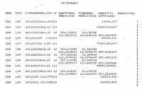
An excerpt: "The rev 34 (deorbit) trajectory for the LM was reconstructed from MSFN doppler data from RID (Madrid, 2-way), MIL, ACN (100 observations pre-burn and 159 observations post-burn), 5 SXT shaft angles, 2 SXT trunnion angles, 7 VHF ranging points, and the thrust profile of the deorbit burn obtained from IMU accelerometer data. The converged residual statistics for all of the observations used in the fit are as follows: No. OBS. Station Type Mean Sigma 86 RID MSFN .348 cps 1.404 cps 87 MIL MSFN .235 cps 1.416 cps 86 ACN MSFN .342 cps 1.356 cps 5 CSM SXT Shaft .001 deg .019 deg 2 CSM SXT Trunnion .033 deg .128 deg 7 CSM VHF Range -470 ft 506 ft The accumulated thrust velocities in IMU platform coordinates due to the deorbit burn are: Delta Vx = -188.57 ft/sec Delta Vy = 54.15 ft/sec Delta Vz = -6.21 ft/sec The time of impact is estimated to be 149:55:16.46 GET. The selenographic coordinates of the impact point are: LATITUDE = -3.944 deg LONGITUDE -21.196 deg RADIUS = 5697847 ft Selenographic Orbit Inclination = -14.531 deg Relative Velocity Magnitude = 5517.2 ft/sec Relative Flight Path Angle = 3.717 deg" Two images from the report offer a little more data. The one shows the above mentioned 7 VHF range data points from the CSM to the LM.
|
||
|
|
|
||
|
May 24 2016, 02:44 AM
Post
#390
|
|
|
Senior Member Group: Members Posts: 3419 Joined: 9-February 04 From: Minneapolis, MN, USA Member No.: 15 |
QUOTE (Phil Stooke @ May 22 2016, 04:53 PM) "If you ran lines back along the streaks, wouldn't that point you back to the origin point of all of them? There couldn't have been a lot of interactions that would have sent off debris on non-radial trajectories, so most of the streaks ought to point directly back to the impact point, right?" If only I had thought of that! Actually - I did: "It would be really nice if this could be traced back to some kind of surface disturbance - even if not a very obvious crater. But I don't see anything of the sort." Phil Of course you did. Sometimes I can sound like an idiot without even trying very hard.  Sorry, it was just the logical thing that popped into my head. I plead pain meds (had an emergency surgery a month ago, to fix something that wasn't connected back up right after those major surgeries I had two years ago... sigh...), it seems like all those little inner voices you can normally filter out keep popping out, in my posts and my conversations. Certainly no offense meant. I'm still fascinated by an impact that could generate relatively strong seismic signals and yet not seem to leave any obvious crater. Gonna have to think about that one. -the other Doug -------------------- The trouble ain't that there is too many fools, but that the lightning ain't distributed right. -Mark Twain
|
|
|
|
|

|
Lo-Fi Version | Time is now: 24th September 2024 - 10:08 AM |
|
RULES AND GUIDELINES Please read the Forum Rules and Guidelines before posting. IMAGE COPYRIGHT |
OPINIONS AND MODERATION Opinions expressed on UnmannedSpaceflight.com are those of the individual posters and do not necessarily reflect the opinions of UnmannedSpaceflight.com or The Planetary Society. The all-volunteer UnmannedSpaceflight.com moderation team is wholly independent of The Planetary Society. The Planetary Society has no influence over decisions made by the UnmannedSpaceflight.com moderators. |
SUPPORT THE FORUM Unmannedspaceflight.com is funded by the Planetary Society. Please consider supporting our work and many other projects by donating to the Society or becoming a member. |
|