Atop/Around the Greenheugh Pediment, Site 79-, sol 2695-3199, 3 Mar 2020-6 Aug 2021 |

  |
Atop/Around the Greenheugh Pediment, Site 79-, sol 2695-3199, 3 Mar 2020-6 Aug 2021 |
 Apr 16 2020, 02:50 AM Apr 16 2020, 02:50 AM
Post
#76
|
|
|
Merciless Robot  Group: Admin Posts: 8784 Joined: 8-December 05 From: Los Angeles Member No.: 602 |
Topic title edited to reflect circumstances.

-------------------- A few will take this knowledge and use this power of a dream realized as a force for change, an impetus for further discovery to make less ancient dreams real.
|
 |
 
|
|
Apr 17 2020, 03:17 PM
Post
#77
|
||
|
Senior Member Group: Members Posts: 2837 Joined: 22-April 05 From: Ridderkerk, Netherlands Member No.: 353 |
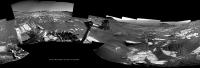
The Navcam L view on Sol 2736.
Jan van Driel
|
|
|
|
|
|
|
Apr 17 2020, 04:29 PM
Post
#78
|
||
|
Senior Member Group: Members Posts: 2837 Joined: 22-April 05 From: Ridderkerk, Netherlands Member No.: 353 |
added 2 images to complete the view.
Jan van Driel
|
|
|
|
|
|
|
Apr 22 2020, 11:19 PM
Post
#79
|
||
|
Senior Member Group: Members Posts: 1074 Joined: 21-September 07 From: Québec, Canada Member No.: 3908 |
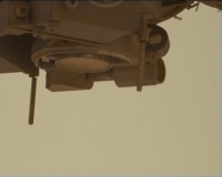
Sol 2741 long-range RMI:
|
|
|
|
|
|
|
Apr 23 2020, 07:43 AM
Post
#80
|
|
|
Member Group: Members Posts: 184 Joined: 2-March 06 Member No.: 692 |
An uncomformity.
|
|
|
|
|
Apr 24 2020, 09:32 AM
Post
#81
|
||
|
Senior Member Group: Members Posts: 2837 Joined: 22-April 05 From: Ridderkerk, Netherlands Member No.: 353 |
The MASTCam R Animation on Sol 2740.
Jan van Driel
|
|
|
|
|
|
|
Apr 25 2020, 01:10 PM
Post
#82
|
|
 Member Group: Members Posts: 810 Joined: 3-June 04 From: Brittany, France Member No.: 79 |
Curiosity rover bypassing Tower Butte on sol 2742:

-------------------- |
|
|
|
|
Apr 26 2020, 01:20 PM
Post
#83
|
||
|
Senior Member Group: Members Posts: 2837 Joined: 22-April 05 From: Ridderkerk, Netherlands Member No.: 353 |
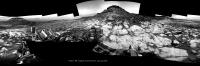
The Navcam L view on Sol 2742-2743.
Jan van Driel
|
|
|
|
|
|
|
Apr 27 2020, 01:04 PM
Post
#84
|
|
|
Member Group: Members Posts: 362 Joined: 13-April 06 From: Malta Member No.: 741 |
Was it always planned for the rover to descend off the pediment back onto the clay unit or did I miss something?
|
|
|
|
|
Apr 27 2020, 01:58 PM
Post
#85
|
||
|
Senior Member Group: Members Posts: 2837 Joined: 22-April 05 From: Ridderkerk, Netherlands Member No.: 353 |
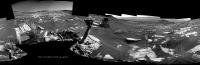
The Navcam L view on Sol 2745.
Jan van Driel
Attached thumbnail(s)
|
|
|
|
|
|
|
Apr 27 2020, 08:16 PM
Post
#86
|
||
|
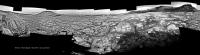
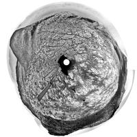
Solar System Cartographer Group: Members Posts: 10173 Joined: 5-April 05 From: Canada Member No.: 227 |
Here is Jan's panorama for sol 2745 in circular form. A nice view of the two buttes nearby.
Phil
-------------------- ... because the Solar System ain't gonna map itself.
Also to be found posting similar content on https://mastodon.social/@PhilStooke Maps for download (free PD: https://upload.wikimedia.org/wikipedia/comm...Cartography.pdf NOTE: everything created by me which I post on UMSF is considered to be in the public domain (NOT CC, public domain) |
|
|
|
|
|
|
Apr 27 2020, 10:13 PM
Post
#87
|
|
|
Senior Member Group: Members Posts: 2517 Joined: 13-September 05 Member No.: 497 |
QUOTE (Julius @ Apr 27 2020, 05:04 AM)  Was it always planned for the rover to descend off the pediment back onto the clay unit or did I miss something? AFAIK this was always the plan, but I'm not sure if it was explicitly said or just somewhat implied in the status reports. See https://mars.nasa.gov/msl/mission-updates/8...diment-for-now/ and note the use of the phrase "mini campaign". -------------------- Disclaimer: This post is based on public information only. Any opinions are my own.
|
|
|
|
|
Apr 27 2020, 10:38 PM
Post
#88
|
|
|
Solar System Cartographer Group: Members Posts: 10173 Joined: 5-April 05 From: Canada Member No.: 227 |
One of the most important targets of the entire mission is the contact between the clay unit in Glen Torridon and the sulfate hills above it, which is assumed to mark a major change in global climate from (let's call it) moist to arid. The Pediment straddles that contact, so if you stay on it you have missed the crucial exposures. They went up because it was possible at that location, so why not have a quick look at it in case a failure ends the mission before they meet it again higher up the mountain.
This LPSC abstract shows the planned path ahead, as of just a few months ago. https://www.hou.usra.edu/meetings/lpsc2020/pdf/2426.pdf Phil -------------------- ... because the Solar System ain't gonna map itself.
Also to be found posting similar content on https://mastodon.social/@PhilStooke Maps for download (free PD: https://upload.wikimedia.org/wikipedia/comm...Cartography.pdf NOTE: everything created by me which I post on UMSF is considered to be in the public domain (NOT CC, public domain) |
|
|
|
|
Apr 28 2020, 12:59 AM
Post
#89
|
|
 Senior Member Group: Members Posts: 2429 Joined: 30-January 13 From: Penang, Malaysia. Member No.: 6853 |
QUOTE (Phil Stooke @ Apr 28 2020, 06:38 AM) This LPSC abstract shows the planned path ahead, as of just a few months ago. Phil Does anyone know if the figures from this abstract are available at a higher resolution? Maybe in another document, or a large poster? I'm particularly interested in Fig1 that shows the MSAR version 9 or later It would be nice to see the detail of the proposed path around the pediment up to the sulfate hills |
|
|
|
|
Apr 28 2020, 05:55 AM
Post
#90
|
|
|
Member Group: Members Posts: 866 Joined: 15-March 05 From: Santa Cruz, CA Member No.: 196 |
One approach is to use the HiRISE browser search for Gale and zoom into the Gedis Valles area and pan and poke around through the madly overlapping needles in that haystack to find the good views like this one. some of that area was also in the 50th LPSC abstract
|
|
|
|
|

|
Lo-Fi Version | Time is now: 1st June 2024 - 08:30 PM |
|
RULES AND GUIDELINES Please read the Forum Rules and Guidelines before posting. IMAGE COPYRIGHT |
OPINIONS AND MODERATION Opinions expressed on UnmannedSpaceflight.com are those of the individual posters and do not necessarily reflect the opinions of UnmannedSpaceflight.com or The Planetary Society. The all-volunteer UnmannedSpaceflight.com moderation team is wholly independent of The Planetary Society. The Planetary Society has no influence over decisions made by the UnmannedSpaceflight.com moderators. |
SUPPORT THE FORUM Unmannedspaceflight.com is funded by the Planetary Society. Please consider supporting our work and many other projects by donating to the Society or becoming a member. |
|