Apollo Sites from LRO |

  |
Apollo Sites from LRO |
 Apr 22 2019, 01:30 PM Apr 22 2019, 01:30 PM
Post
#451
|
||
|
Solar System Cartographer  Group: Members Posts: 10227 Joined: 5-April 05 From: Canada Member No.: 227 |
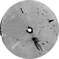
Back to Apollo 17. On the return leg of EVA 2 the astronauts stopped at Victory crater, really a V-shaped secondary crater. After dropping off an explosive charge and just prior to collecting a small sample they made a rover panorama. Cernan drove the LRV in a tight circle around the explosive charge while Schmitt took a series of images. This is the resulting panorama. The foregrounds don't match up well because the viewpoint is changing, but the background offers the only detailed view of Victory from the surface (right-hand end of the panorama).
Phil
-------------------- ... because the Solar System ain't gonna map itself.
Also to be found posting similar content on https://mastodon.social/@PhilStooke Maps for download (free PDF: https://upload.wikimedia.org/wikipedia/comm...Cartography.pdf NOTE: everything created by me which I post on UMSF is considered to be in the public domain (NOT CC, public domain) |
|
 |
 
|
|
|
Oct 21 2019, 12:12 AM
Post
#452
|
||
|
Solar System Cartographer Group: Members Posts: 10227 Joined: 5-April 05 From: Canada Member No.: 227 |
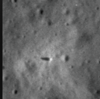
Too many other things happening at the moment to move quickly on Apollo 17, but here is where I am at the moment. This is Station 7 on North Massif. The Station 7 panorama projected, taking slope into account. I am mapping EVA 3 with a goal of making the Apollo 17 EVAs my LPSC poster topic.
Phil
-------------------- ... because the Solar System ain't gonna map itself.
Also to be found posting similar content on https://mastodon.social/@PhilStooke Maps for download (free PDF: https://upload.wikimedia.org/wikipedia/comm...Cartography.pdf NOTE: everything created by me which I post on UMSF is considered to be in the public domain (NOT CC, public domain) |
|
|
|
|
|
|
Oct 21 2019, 06:48 AM
Post
#453
|
|
|
Member Group: Members Posts: 184 Joined: 2-March 06 Member No.: 692 |
I can never get over how bold this adventure was. Looking forward to your poster!
|
|
|
|
|
Oct 10 2020, 08:37 AM
Post
#454
|
||
|
Junior Member Group: Members Posts: 38 Joined: 7-October 20 Member No.: 8895 |
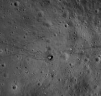
Apollo 17th Challenger in one piece with both ascent and descent stages.
This was taken from Apollo17 CSM after Challenger had landed on lunar surface (4 hrs after it's landing) Was enhanced from this image - http://wms.lroc.asu.edu/apollo/view?camera...ame=AS17-P-2314
|
|
|
|
|
|
|
Oct 23 2020, 10:48 PM
Post
#455
|
||
|
Solar System Cartographer Group: Members Posts: 10227 Joined: 5-April 05 From: Canada Member No.: 227 |
A nice picture, Shan. It's interesting to compare it with an LRO image (in this case M168000580R). The resolution of the LRO image is significantly better (not all are this good, of course).
Phil
-------------------- ... because the Solar System ain't gonna map itself.
Also to be found posting similar content on https://mastodon.social/@PhilStooke Maps for download (free PDF: https://upload.wikimedia.org/wikipedia/comm...Cartography.pdf NOTE: everything created by me which I post on UMSF is considered to be in the public domain (NOT CC, public domain) |
|
|
|
|
|
|
Oct 24 2020, 05:31 PM
Post
#456
|
||
|
Junior Member Group: Members Posts: 38 Joined: 7-October 20 Member No.: 8895 |
QUOTE (Phil Stooke @ Oct 24 2020, 04:18 AM)  A nice picture, Shan. It's interesting to compare it with an LRO image (in this case M168000580R). The resolution of the LRO image is significantly better (not all are this good, of course). Phil
Thanks Phil.. My idea was just to see what would have been the view from command module when the 2 astronauts were walking on the Moon.. And the above one I posted was 4 hrs after the landing & the 2 astronauts were in the process of taking out the LRV & that's the reason you don't see a lot of disturbance.. |
|
|
|
|
|
|
Oct 24 2020, 06:44 PM
Post
#457
|
|
|
Solar System Cartographer Group: Members Posts: 10227 Joined: 5-April 05 From: Canada Member No.: 227 |
Yes, that before-after comparison is interesting as well. I was looking more at the visibility of small craters. People sometimes talk about the Apollo panoramic camera images as if they are about the same resolution as the LRO NAC images, and the best ones are comparable, but generally they are not as good as LRO.
Phil -------------------- ... because the Solar System ain't gonna map itself.
Also to be found posting similar content on https://mastodon.social/@PhilStooke Maps for download (free PDF: https://upload.wikimedia.org/wikipedia/comm...Cartography.pdf NOTE: everything created by me which I post on UMSF is considered to be in the public domain (NOT CC, public domain) |
|
|
|
|
Jul 16 2021, 09:18 PM
Post
#458
|
||
 Member Group: Members Posts: 349 Joined: 20-June 07 From: Slovenia Member No.: 2461 |
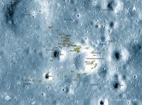
LROC website recently updated traverse data for Apollo 11, 12 and 14. I could not resist turning it into my usual traverse map style. I liked the results, especially for Apollo 12, so I wanted to share it with all of you. Note separate tracks for commander (Conrad, orange) and lunar module pilot (Bean, green). Will post A11 and A14 in near feature. |
|
|
|
|
|
|
Jul 16 2021, 09:36 PM
Post
#459
|
|
|
Solar System Cartographer Group: Members Posts: 10227 Joined: 5-April 05 From: Canada Member No.: 227 |
Apollo 15 will be coming to their site soon.
Phil -------------------- ... because the Solar System ain't gonna map itself.
Also to be found posting similar content on https://mastodon.social/@PhilStooke Maps for download (free PDF: https://upload.wikimedia.org/wikipedia/comm...Cartography.pdf NOTE: everything created by me which I post on UMSF is considered to be in the public domain (NOT CC, public domain) |
|
|
|
|
Aug 3 2021, 11:51 PM
Post
#460
|
|
|
Solar System Cartographer Group: Members Posts: 10227 Joined: 5-April 05 From: Canada Member No.: 227 |
Apollo 15, new website with a traverse map you can follow step by step.
Phil http://lroc.sese.asu.edu/posts/1198 -------------------- ... because the Solar System ain't gonna map itself.
Also to be found posting similar content on https://mastodon.social/@PhilStooke Maps for download (free PDF: https://upload.wikimedia.org/wikipedia/comm...Cartography.pdf NOTE: everything created by me which I post on UMSF is considered to be in the public domain (NOT CC, public domain) |
|
|
|
|
Aug 4 2021, 07:08 AM
Post
#461
|
|
|
Member Group: Members Posts: 184 Joined: 2-March 06 Member No.: 692 |
I was at the cape to see this mission launched. I'll never forget the sound; my chest being hit by punches and the ground shaking. What a grand time to be alive.
|
|
|
|
|
Aug 4 2021, 01:24 PM
Post
#462
|
||
|
Member Group: Members Posts: 349 Joined: 20-June 07 From: Slovenia Member No.: 2461 |
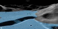
The view of Apollo 15's traverses from the other side of the Hadley's rille. The view is really spectacular. I can only hope they will also update Apollos 16/17 in the future. |
|
|
|
|
|
|
Oct 6 2021, 08:21 PM
Post
#463
|
|
|
Senior Member Group: Members Posts: 2922 Joined: 14-February 06 From: Very close to the Pyrénées Mountains (France) Member No.: 682 |
Discovered this article (in French) that says that Eagles 2nd stage could still be in lunar orbit : https://blogs.futura-sciences.com/feldmann/...orbite-lunaire/
I put it here because, if not true, I the crash site could have been spotted by LRO. Somebody has a clue ? Thanks -------------------- |
|
|
|
|
Oct 7 2021, 07:23 AM
Post
#464
|
|
|
Solar System Cartographer Group: Members Posts: 10227 Joined: 5-April 05 From: Canada Member No.: 227 |
https://arxiv.org/pdf/2105.10088
This is the actual link to the preprint - it has now been published. The conclusion is that the LM Ascent Stage is in a stable orbit that has not impacted on the Moon yet. Phil -------------------- ... because the Solar System ain't gonna map itself.
Also to be found posting similar content on https://mastodon.social/@PhilStooke Maps for download (free PDF: https://upload.wikimedia.org/wikipedia/comm...Cartography.pdf NOTE: everything created by me which I post on UMSF is considered to be in the public domain (NOT CC, public domain) |
|
|
|
|
Mar 22 2022, 08:36 PM
Post
#465
|
|
|
Solar System Cartographer Group: Members Posts: 10227 Joined: 5-April 05 From: Canada Member No.: 227 |
This link:
https://snoopy.rogertwank.net/2022/03/orion...-of-impact.html is to a blog post by Jim Meador about the Apollo 16 lunar module ascent stage. It suggests an impact which was actually detected in ALSEP seismic data, but unfortunately the impact has not yet been located in LRO images. Phil -------------------- ... because the Solar System ain't gonna map itself.
Also to be found posting similar content on https://mastodon.social/@PhilStooke Maps for download (free PDF: https://upload.wikimedia.org/wikipedia/comm...Cartography.pdf NOTE: everything created by me which I post on UMSF is considered to be in the public domain (NOT CC, public domain) |
|
|
|
|

|
Lo-Fi Version | Time is now: 25th September 2024 - 11:01 AM |
|
RULES AND GUIDELINES Please read the Forum Rules and Guidelines before posting. IMAGE COPYRIGHT |
OPINIONS AND MODERATION Opinions expressed on UnmannedSpaceflight.com are those of the individual posters and do not necessarily reflect the opinions of UnmannedSpaceflight.com or The Planetary Society. The all-volunteer UnmannedSpaceflight.com moderation team is wholly independent of The Planetary Society. The Planetary Society has no influence over decisions made by the UnmannedSpaceflight.com moderators. |
SUPPORT THE FORUM Unmannedspaceflight.com is funded by the Planetary Society. Please consider supporting our work and many other projects by donating to the Society or becoming a member. |
|