Radar And Mariner 10, Best possible mapping, pre-Messenger |

  |
Radar And Mariner 10, Best possible mapping, pre-Messenger |
 Dec 9 2006, 06:37 PM Dec 9 2006, 06:37 PM
Post
#46
|
||
 Member  Group: Members Posts: 106 Joined: 26-September 05 Member No.: 508 |
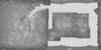
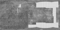
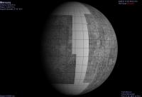
While reading this thread I realized I made the cylindrical map at http://www.lpl.arizona.edu/~rhill/alpo/mer...f/messenger.pdf, so here is my version of Phil's map.
Attached thumbnail(s)
|
|
 |
 
|
|
|
Dec 9 2006, 08:10 PM
Post
#47
|
|
 Senior Member Group: Members Posts: 3419 Joined: 9-February 04 From: Minneapolis, MN, USA Member No.: 15 |
Mucho, mucho gracias for the maps, Phil and Tayfun. To borrow a phrase... fascinating!
-the other Doug -------------------- The trouble ain't that there is too many fools, but that the lightning ain't distributed right. -Mark Twain
|
|
|
|
|
Apr 8 2007, 06:18 PM
Post
#48
|
|||
|
Solar System Cartographer Group: Members Posts: 10227 Joined: 5-April 05 From: Canada Member No.: 227 |
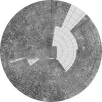
I have updated my composite map of Mercury, adding a few extra bits from remaining radar images from the paper cited earlier. Wherever possible I have merged at least two overlapping images with different radar equators to reduce the north-south ambiguity. This is probably as good as it's going to get before Messenger arrives, unless new radar images suddenly appear.
Phil
This is the northern hemisphere:
Phil -------------------- ... because the Solar System ain't gonna map itself.
Also to be found posting similar content on https://mastodon.social/@PhilStooke Maps for download (free PDF: https://upload.wikimedia.org/wikipedia/comm...Cartography.pdf NOTE: everything created by me which I post on UMSF is considered to be in the public domain (NOT CC, public domain) |
||
|
|
|
||
|
Apr 8 2007, 06:19 PM
Post
#49
|
||
|
Solar System Cartographer Group: Members Posts: 10227 Joined: 5-April 05 From: Canada Member No.: 227 |
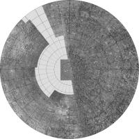
... and the southern hemisphere:
Phil -------------------- ... because the Solar System ain't gonna map itself.
Also to be found posting similar content on https://mastodon.social/@PhilStooke Maps for download (free PDF: https://upload.wikimedia.org/wikipedia/comm...Cartography.pdf NOTE: everything created by me which I post on UMSF is considered to be in the public domain (NOT CC, public domain) |
|
|
|
|
|
|
Apr 8 2007, 07:34 PM
Post
#50
|
||
 Senior Member Group: Moderator Posts: 3241 Joined: 11-February 04 From: Tucson, AZ Member No.: 23 |
Using the above map, I ran through the first MESSENGER flyby in Celestia:
-------------------- &@^^!% Jim! I'm a geologist, not a physicist!
The Gish Bar Times - A Blog all about Jupiter's Moon Io |
|
|
|
|
|
|
Apr 8 2007, 07:48 PM
Post
#51
|
|
 Senior Member Group: Members Posts: 3648 Joined: 1-October 05 From: Croatia Member No.: 523 |
Nice view VP. One thing I always wondered about visualization programs like Celestia is what kind of map projections they assume as textures. I always thought cylindric texture maps were required, but the vertical spacing of latitude lines in your view seems to be shrinking at the poles. Is this normal or is it suggesting a spherical projection maybe?
EDIT: On second thought, latitude lines shrinking is logical when properly mapped. I'd also expect cylindrical maps to behave the same so my non-extitent expertise in maps leads me to believe Phil's map is not cylindric, correct? -------------------- |
|
|
|
|
Apr 8 2007, 08:30 PM
Post
#52
|
|
|
Solar System Cartographer Group: Members Posts: 10227 Joined: 5-April 05 From: Canada Member No.: 227 |
That is really cool, VP, thanks.
ugordan, I think you're just seeing the foreshortening one would expect near the limbs, north and south. My map was simple cylindrical, equal spacing of meridians and parallels. THere are other clindrical projections - Mercator, where spacing increases towards the poles to preserve conformality (shape), and perspective cylindrical where they get close towards the poles to preserve area. Every planetary scientist should take a course in map projections! Phil -------------------- ... because the Solar System ain't gonna map itself.
Also to be found posting similar content on https://mastodon.social/@PhilStooke Maps for download (free PDF: https://upload.wikimedia.org/wikipedia/comm...Cartography.pdf NOTE: everything created by me which I post on UMSF is considered to be in the public domain (NOT CC, public domain) |
|
|
|
|
Apr 8 2007, 08:39 PM
Post
#53
|
|
|
Senior Member Group: Members Posts: 3648 Joined: 1-October 05 From: Croatia Member No.: 523 |
I see, Phil. I was under the impression that in 3D graphics, by "cylindrical" that which you describe as perspective cylindrical is implied, whereas in "spherical" map your simple cylindrical map was assumed.
I never could figure out the terminology. Then again, I don't call myself a planetary scientist so you'll have to forgive me. 
-------------------- |
|
|
|
|
Apr 9 2007, 03:16 AM
Post
#54
|
|
|
Solar System Cartographer Group: Members Posts: 10227 Joined: 5-April 05 From: Canada Member No.: 227 |
I don't mean you! But I encounter so many scientists who use maps all the time and don't understand them at all... Some terrible things are done in the name of cartography, even in the best journals. Perhaps the most common is referring to any cylindrical projection as Mercator.
Phil -------------------- ... because the Solar System ain't gonna map itself.
Also to be found posting similar content on https://mastodon.social/@PhilStooke Maps for download (free PDF: https://upload.wikimedia.org/wikipedia/comm...Cartography.pdf NOTE: everything created by me which I post on UMSF is considered to be in the public domain (NOT CC, public domain) |
|
|
|
|
Apr 9 2007, 03:51 PM
Post
#55
|
|
 Senior Member Group: Members Posts: 1281 Joined: 18-December 04 From: San Diego, CA Member No.: 124 |
QUOTE (Phil Stooke @ Apr 8 2007, 08:16 PM)  Some terrible things are done in the name of cartography Would this be the cynical projection?  One of the things I truly love about this forum (among many others) is how much I learn and how much threads like this inspire me to educate myself even more. I stole my one of my wife's GIS manuals for a little light night reading and what do you know, it's online as well: ESRI's Understanding Map Projections (2 MB PDF file) Beginner level, but I found it helpful.... I trust that the system works for Mars as well as Earth, though Eros, Itokawa et al might require different coordinate systems? Phil? This page has a good set of references for the cartographically challenged: Harvard GIS Resources And of course, what enthusiast autodidact post would be complete without mentioning the golden oldies: Remote Sensing Tutorial and JPL's Basics of Spaceflight -------------------- Lyford Rome
"Zis is not nuts, zis is super-nuts!" Mathematician Richard Courant on viewing an Orion test |
|
|
|
|
Apr 9 2007, 07:02 PM
Post
#56
|
|
 Interplanetary Dumpster Diver Group: Admin Posts: 4404 Joined: 17-February 04 From: Powell, TN Member No.: 33 |
All this is well and good, Phil, but let me ask you a more sophisticated question. When you get a map out, whether it be cylindrical, mercator, or whatever, can you fold it back up properly?

-------------------- |
|
|
|
|
Apr 9 2007, 07:27 PM
Post
#57
|
|
|
Solar System Cartographer Group: Members Posts: 10227 Joined: 5-April 05 From: Canada Member No.: 227 |
Yes, Ted, I use them to make cootie-catchers... or like this:
http://www.ssc.uwo.ca/geography/spacemap/psg.jpg and http://www.ssc.uwo.ca/geography/spacemap/png.jpg which really do fold up! Phil -------------------- ... because the Solar System ain't gonna map itself.
Also to be found posting similar content on https://mastodon.social/@PhilStooke Maps for download (free PDF: https://upload.wikimedia.org/wikipedia/comm...Cartography.pdf NOTE: everything created by me which I post on UMSF is considered to be in the public domain (NOT CC, public domain) |
|
|
|
|
Apr 9 2007, 08:34 PM
Post
#58
|
|
 Senior Member Group: Members Posts: 2530 Joined: 20-April 05 Member No.: 321 |
[...]
|
|
|
|
|
Apr 10 2007, 06:05 PM
Post
#59
|
|
|
Member Group: Members Posts: 172 Joined: 17-March 06 Member No.: 709 |
The significance of all of this effort to squeeze out interpretations of Mercury's
surface from fuzzy Radar or Earth-based telescopes lies in our future efforts to image Extra-Solar Terrestrial Planets. When the Planet Imager flies (someday) after TPF, the images of those worlds will be astonishing, but they will still be only fuzzy views, much as we see Mercury today from Earth-based telescopes. However, by then, we will have had additional experience in interpreting those images because of this present effort. It will be very revealing to see what Messenger tells us, within a few months, about these present estimates of what Mercury's "Far Side" will look like. Another Phil |
|
|
|
|
Apr 10 2007, 06:09 PM
Post
#60
|
|
|
Solar System Cartographer Group: Members Posts: 10227 Joined: 5-April 05 From: Canada Member No.: 227 |
I will go on record saying that I don't believe in Skinakas.
Phil -------------------- ... because the Solar System ain't gonna map itself.
Also to be found posting similar content on https://mastodon.social/@PhilStooke Maps for download (free PDF: https://upload.wikimedia.org/wikipedia/comm...Cartography.pdf NOTE: everything created by me which I post on UMSF is considered to be in the public domain (NOT CC, public domain) |
|
|
|
|

|
Lo-Fi Version | Time is now: 25th September 2024 - 10:43 AM |
|
RULES AND GUIDELINES Please read the Forum Rules and Guidelines before posting. IMAGE COPYRIGHT |
OPINIONS AND MODERATION Opinions expressed on UnmannedSpaceflight.com are those of the individual posters and do not necessarily reflect the opinions of UnmannedSpaceflight.com or The Planetary Society. The all-volunteer UnmannedSpaceflight.com moderation team is wholly independent of The Planetary Society. The Planetary Society has no influence over decisions made by the UnmannedSpaceflight.com moderators. |
SUPPORT THE FORUM Unmannedspaceflight.com is funded by the Planetary Society. Please consider supporting our work and many other projects by donating to the Society or becoming a member. |
|