Updated Titan Map |

  |
Updated Titan Map |
 Jun 22 2007, 07:20 PM Jun 22 2007, 07:20 PM
Post
#91
|
|
 Senior Member  Group: Moderator Posts: 2785 Joined: 10-November 06 From: Pasadena, CA Member No.: 1345 |
Apologies! I meant "That's a really good point, DOUG".
(With all this new information, the connection between the two hemispheres of Juramike's brain finally snapped. Juramike could never again place the name of an object with it's shape. For the rest of his natural life, Juramike referred to any bowl-like object as "crater" ) 
-------------------- Some higher resolution images available at my photostream: http://www.flickr.com/photos/31678681@N07/
|
 |
 
|
|
Jun 22 2007, 10:20 PM
Post
#92
|
|
 Senior Member Group: Members Posts: 1669 Joined: 5-March 05 From: Boulder, CO Member No.: 184 |
Hi again,
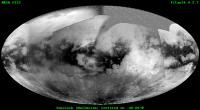
I've made a few more map updates and increased the size to 4K. This is also now posted on my regular web site at the following URL: http://laps.fsl.noaa.gov/albers/sos/sos.html#TITAN Interesting to see what looks like those long rivers flowing toward the seas of the north pole. -------------------- Steve [ my home page and planetary maps page ]
|
|
|
|
|
Jun 23 2007, 05:05 AM
Post
#93
|
||
 Senior Member Group: Members Posts: 1887 Joined: 20-November 04 From: Iowa Member No.: 110 |
QUOTE (David @ Jun 21 2007, 07:04 PM)  Very nice! But it gets me thinking again about the global distributions of different terrains and climates on Titan. The overall picture seems clear: Titan is a semi-desert moon, wet at the poles, very dry around the equator, with an equatorial belt of sand-seas in (it seems) lower terrain. Which raises the following questions for me: 1) Why is the equatorial belt so irregular in shape? Just chance variations in elevation? 2) What constrains the desert belt to north and south? Or to put it another way, what's going on in the temperate zone in terrains that would be deserts if they were equatorial? Looking at the global view I see three different units: large areas of bright terrain, the dark 'sand seas' forming an incomplete belt around the crater, and below 30 degrees south a gray area. The gray area appears to have been overlooked in these discussions. Anyone have an idea about why it is it different that the bright terrain with a similar latitude in the northern hemisphere?
|
|
|
|
|
|
|
Jun 23 2007, 04:32 PM
Post
#94
|
|
|
Member Group: Members Posts: 813 Joined: 29-December 05 From: NE Oh, USA Member No.: 627 |
Beautiful work ....
Agree that Titan seems to be a desert world but we have to be careful not to carry that analogy too far. Remember that Huygens detected a lot of methane coming out of the ice/hdrocarbon regolith (smurst?) after it impacted. I am REALLY looking forward to better views of the southern pole. We need to understand how the the 7 year summer at the south pole has affected the methane cycle and the geochemistry and geophysics in that region as well. More FUN coming up juramike!!!!!!!! Craig |
|
|
|
|
Jun 23 2007, 07:23 PM
Post
#95
|
|
|
Solar System Cartographer Group: Members Posts: 10226 Joined: 5-April 05 From: Canada Member No.: 227 |
stevesliva said:
"That's nice! Although a mercator projection centered at the equator distorts exactly what is interesting at Titan... " I want to comment on this because I have encountered this elsewhere. The most fundamental cartographic product - and the hardest to make - is the initial global mosaic itself. Once you have it, it can be reprojected into any other form of map with appropriate software. I will post a polar view of Steve's new map later to demonstrate. Don't think of the simple cylindrical map as an end in itself, it's an image database which can be turned into any other map projection, or wrapped around a sphere, or animated... etc. And frankly the simple cylindrical is just about the easiest of those things to make the other products from. I encountered this with my new Eros mosaic - why make an old-fashioned flat map? Why not project it onto a 3-D shape model and animate it? - but where do you think the mosaic to project onto the model comes from in the first place? (oh, and yes, it's not Mercator! It's Simple Cylindrical, where a degree is represented by a specified number of pixels in both E-W or N-S directions. In Mercator the N-S spacing varies away from the equator.) Phil -------------------- ... because the Solar System ain't gonna map itself.
Also to be found posting similar content on https://mastodon.social/@PhilStooke Maps for download (free PDF: https://upload.wikimedia.org/wikipedia/comm...Cartography.pdf NOTE: everything created by me which I post on UMSF is considered to be in the public domain (NOT CC, public domain) |
|
|
|
|
Jun 23 2007, 08:44 PM
Post
#96
|
|
|
Senior Member Group: Members Posts: 3516 Joined: 4-November 05 From: North Wales Member No.: 542 |
I can't wait for that polar version. I've been hoping someone would provide a south polar map of Titan for ages. I even posted a request on CICLOPS. So far I've only seen it in small PDF format used as a base for the flyby groundtracks.
|
|
|
|
|
Jun 23 2007, 09:15 PM
Post
#97
|
|||
|
Solar System Cartographer Group: Members Posts: 10226 Joined: 5-April 05 From: Canada Member No.: 227 |
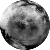
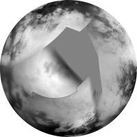
southern hemisphere:
Northern hemisphere:
Phil -------------------- ... because the Solar System ain't gonna map itself.
Also to be found posting similar content on https://mastodon.social/@PhilStooke Maps for download (free PDF: https://upload.wikimedia.org/wikipedia/comm...Cartography.pdf NOTE: everything created by me which I post on UMSF is considered to be in the public domain (NOT CC, public domain) |
||
|
|
|
||
|
Jun 23 2007, 09:16 PM
Post
#98
|
|
|
Senior Member Group: Members Posts: 3516 Joined: 4-November 05 From: North Wales Member No.: 542 |
Hallelujah!
|
|
|
|
|
Jun 24 2007, 12:40 AM
Post
#99
|
|
 Member Group: Members Posts: 809 Joined: 11-March 04 Member No.: 56 |
Beautiful, just beautiful. Now that we've seen the radar of the northern region, it's a little easier to interpret the dark markings at the south pole, although it now becomes a matter of wonder why the 'bean-shaped' lake is, not just a lake, but one with such smooth and nicely curved boundaries, unlike both the northern lakes and the other lakes in its vicinity.
I wonder if the "gray" areas in the temperate zones might be -- I'm not sure of a proper terminology that doesn't imply vegetation, but anyway -- swamp, or wetland -- shallow lacustrine regions that are intermittently (seasonally?) dry, or at any rate more like perpetually damp, methanelogged land, than like lakes, thus perhaps being an intermediate term between the polar lakes and the equatorial deserts, which (as suggested above) might be concealing a fair bit of subterranean moisture as well. |
|
|
|
|
Jun 24 2007, 06:03 AM
Post
#100
|
|
|
Senior Member Group: Members Posts: 1887 Joined: 20-November 04 From: Iowa Member No.: 110 |
QUOTE (David @ Jun 23 2007, 07:40 PM) I wonder if the "gray" areas in the temperate zones might be -- I'm not sure of a proper terminology that doesn't imply vegetation, but anyway -- swamp, or wetland -- shallow lacustrine regions that are intermittently (seasonally?) dry, or at any rate more like perpetually damp, methanelogged land, than like lakes, thus perhaps being an intermediate term between the polar lakes and the equatorial deserts, which (as suggested above) might be concealing a fair bit of subterranean moisture as well. Maybe they aren't perpetually damp. It could be a seasonal change. I'll stick my neck out and make a wild prediction: after the equinox the gray area in the southern hemisphere will brighten and a new gray area will form in the northern hemisphere. Remember, you heard it here first. |
|
|
|
|
Jun 24 2007, 10:12 AM
Post
#101
|
|
 Member Group: Members Posts: 221 Joined: 25-March 05 Member No.: 217 |
This is my first post on a Titan thread.
The Bean shaped lake looks like it is sitting in a volcanic caldera. I know it's only a 2d map on which deapth is very hard to infer, the area around the lake seems to be sloping away from it. Roy 
|
|
|
|
|
Jun 25 2007, 12:42 PM
Post
#102
|
||||
 Lord Of The Uranian Rings Group: Members Posts: 798 Joined: 18-July 05 From: Plymouth, UK Member No.: 437 |
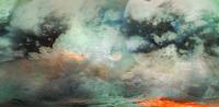
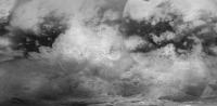
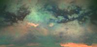
I'm not sure how useful this will be, but here's my attempt at combining the ISS and VIMS mosiacs of Titan:
The original ISS image (thanks Steve!):
The original VIMS from the JPL Photojournal (latitude and longitude lines removed):
Ian. -------------------- |
|||
|
|
|
|||
|
Jun 25 2007, 12:49 PM
Post
#103
|
|
|
Senior Member Group: Members Posts: 3516 Joined: 4-November 05 From: North Wales Member No.: 542 |
QUOTE (David @ Jun 24 2007, 01:40 AM) it now becomes a matter of wonder why the 'bean-shaped' lake is, not just a lake, but one with such smooth and nicely curved boundaries, unlike both the northern lakes and the other lakes in its vicinity. I think the bean-shaped Ontario Lacus does in fact resemble the individual lobate extremities of the large northern lake as seen by ISS, both in size and apparent roundness. |
|
|
|
|
Jun 25 2007, 02:41 PM
Post
#104
|
||
|
Senior Member Group: Moderator Posts: 2785 Joined: 10-November 06 From: Pasadena, CA Member No.: 1345 |
Dear Steve, Alan, and Phil,
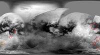
Wow! That's an awesome combination (of effort and images)! Based on this combination of ISS and VIMS images, I speculatively identified additional "circular objects of interest" beyond those in this post. Here are the newly tentatively identified "craterforms" drawn on the mosaic made by Steve (Circles drawn outside the tentative diameter of the craterform for clarity):
What is also really cool about the combo of ISS and VIMS data is the huge amount of dark blue ice sand in the outer dark halo of Minrva. This would help support that connection between the dark blue ice sand halo and Minrva. Wow! -Mike -------------------- Some higher resolution images available at my photostream: http://www.flickr.com/photos/31678681@N07/
|
|
|
|
|
|
|
Jun 25 2007, 02:56 PM
Post
#105
|
|
|
Member Group: Members Posts: 688 Joined: 20-April 05 From: Sweden Member No.: 273 |
QUOTE (David @ Jun 24 2007, 02:40 AM) I wonder if the "gray" areas in the temperate zones might be -- I'm not sure of a proper terminology that doesn't imply vegetation, but anyway -- swamp, or wetland -- shallow lacustrine regions that are intermittently (seasonally?) dry, or at any rate more like perpetually damp, methanelogged land, than like lakes, thus perhaps being an intermediate term between the polar lakes and the equatorial deserts, which (as suggested above) might be concealing a fair bit of subterranean moisture as well. The word you are looking for is "playa" tty |
|
|
|
|

|
Lo-Fi Version | Time is now: 21st September 2024 - 01:36 PM |
|
RULES AND GUIDELINES Please read the Forum Rules and Guidelines before posting. IMAGE COPYRIGHT |
OPINIONS AND MODERATION Opinions expressed on UnmannedSpaceflight.com are those of the individual posters and do not necessarily reflect the opinions of UnmannedSpaceflight.com or The Planetary Society. The all-volunteer UnmannedSpaceflight.com moderation team is wholly independent of The Planetary Society. The Planetary Society has no influence over decisions made by the UnmannedSpaceflight.com moderators. |
SUPPORT THE FORUM Unmannedspaceflight.com is funded by the Planetary Society. Please consider supporting our work and many other projects by donating to the Society or becoming a member. |
|