Atop/Around the Greenheugh Pediment, Site 79-, sol 2695-3199, 3 Mar 2020-6 Aug 2021 |

  |
Atop/Around the Greenheugh Pediment, Site 79-, sol 2695-3199, 3 Mar 2020-6 Aug 2021 |
 Apr 10 2020, 10:47 AM Apr 10 2020, 10:47 AM
Post
#61
|
|
 Senior Member  Group: Members Posts: 1619 Joined: 12-February 06 From: Bergerac - FR Member No.: 678 |
Quoting myself because this panorama is finally over. I missed one frame to complete it, and this frame was available tonight. So
QUOTE (Ant103 @ Mar 13 2020, 06:17 PM)  Sol 2700 loooooooooooooooooooooooooooooooooooong Mastcam100 mosaic showing a hell of details there. 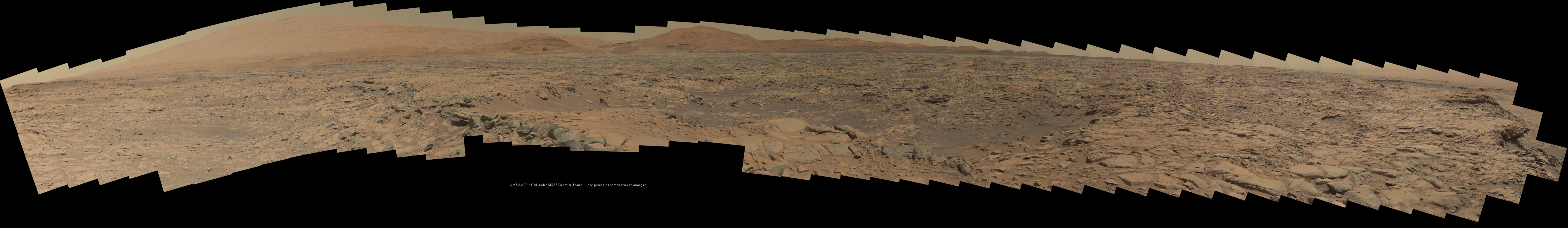 -------------------- |
 |
 
|
|
Apr 11 2020, 12:09 AM
Post
#62
|
|
|
Junior Member Group: Members Posts: 95 Joined: 11-January 07 From: Amsterdam Member No.: 1584 |
new navcams! and why not view them in the latest version of my navcam viewer?
https://captainvideo.nl/rob/navcamdiary.html press tab or the topright circle for a sol list press h for other options stay safe, all of you! -------------------- |
|
|
|
|
Apr 11 2020, 12:59 AM
Post
#63
|
||
|
Senior Member Group: Members Posts: 1074 Joined: 21-September 07 From: Québec, Canada Member No.: 3908 |
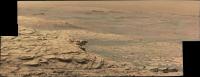
Sol 2729 long-range RMI mosaic:
|
|
|
|
|
|
|
Apr 11 2020, 01:50 AM
Post
#64
|
||
 Member Group: Members Posts: 684 Joined: 24-July 15 Member No.: 7619 |
QUOTE (charborob @ Apr 9 2020, 04:45 PM) A second long-range RMI mosaic from sol 2728: [attachment=45782:sol_2728_rmi_1.jpg] Do we have another "spoon" of suspended rock in that RMI? Like what we saw around Sol 1070-1089?
Attached thumbnail(s)
|
|
|
|
|
|
|
Apr 11 2020, 12:06 PM
Post
#65
|
|
 Member Group: Members Posts: 809 Joined: 3-June 04 From: Brittany, France Member No.: 79 |
-------------------- |
|
|
|
|
Apr 11 2020, 01:11 PM
Post
#66
|
||
|
Senior Member Group: Members Posts: 2824 Joined: 22-April 05 From: Ridderkerk, Netherlands Member No.: 353 |
The Navcam L view on Sol 2729.
Jan van Driel
|
|
|
|
|
|
|
Apr 11 2020, 06:29 PM
Post
#67
|
||
|
Solar System Cartographer Group: Members Posts: 10159 Joined: 5-April 05 From: Canada Member No.: 227 |
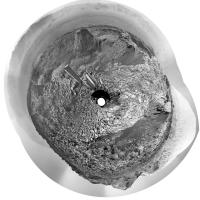
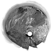
Thanks, Jan. Here is a circular view of it showing how we have moved away from the edge of that depression. The recent updates have indicated we will drive off the pediment and resume the previous path around its edge to the east, then up into the hills.
Phil
-------------------- ... because the Solar System ain't gonna map itself.
Also to be found posting similar content on https://mastodon.social/@PhilStooke Maps for download (free PD: https://upload.wikimedia.org/wikipedia/comm...Cartography.pdf NOTE: everything created by me which I post on UMSF is considered to be in the public domain (NOT CC, public domain) |
|
|
|
|
|
|
Apr 13 2020, 01:58 PM
Post
#68
|
||
|
Senior Member Group: Members Posts: 2824 Joined: 22-April 05 From: Ridderkerk, Netherlands Member No.: 353 |
The Mastcam L view on Sol 2729.
Jan van Driel
|
|
|
|
|
|
|
Apr 13 2020, 06:03 PM
Post
#69
|
||
|
Senior Member Group: Members Posts: 2824 Joined: 22-April 05 From: Ridderkerk, Netherlands Member No.: 353 |
The Navcam L view on Sol 2732.
Jan van Driel
|
|
|
|
|
|
|
Apr 14 2020, 03:33 PM
Post
#70
|
|
|
Member Group: Members Posts: 809 Joined: 3-June 04 From: Brittany, France Member No.: 79 |
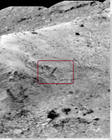
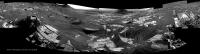
My take on the MastCam Right mosaic of sol 2729, with 5 extra Matt Damon added to give a scale
 The furthest one is at ~580m from Curiosity rover. 
-------------------- |
|
|
|
|
Apr 14 2020, 08:35 PM
Post
#71
|
||
|
Solar System Cartographer Group: Members Posts: 10159 Joined: 5-April 05 From: Canada Member No.: 227 |
Don't jump, Matt! There's still hope for a sequel!
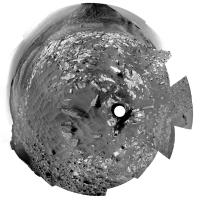
Also, here is Jan's new panorama in circular form. We have moved right to the edge of the pediment again at the same place we climbed it earlier. The tracks are visible just below us. Phil
-------------------- ... because the Solar System ain't gonna map itself.
Also to be found posting similar content on https://mastodon.social/@PhilStooke Maps for download (free PD: https://upload.wikimedia.org/wikipedia/comm...Cartography.pdf NOTE: everything created by me which I post on UMSF is considered to be in the public domain (NOT CC, public domain) |
|
|
|
|
|
|
Apr 14 2020, 10:09 PM
Post
#72
|
|
|
Senior Member Group: Members Posts: 1043 Joined: 17-February 09 Member No.: 4605 |
Found Wally. Thanks for the humour neo.
|
|
|
|
|
Apr 15 2020, 12:22 AM
Post
#73
|
|
|
Member Group: Members Posts: 866 Joined: 15-March 05 From: Santa Cruz, CA Member No.: 196 |
Thanks neo56 for the great image treatment, i inspected jvandiel's stitch of the same sequence yesterday and was frustrated trying to get a handle on the scale of things, and since i tend to overestimate the scale of things in the near-scope pancams, i now see im overcompensating for the larger scale sequences, i so misunderestimated that protruding part of the rock to be only about the size of Mark Watney's boot, off by over 3x..
|
|
|
|
|
Apr 15 2020, 06:43 PM
Post
#74
|
||
|
Senior Member Group: Members Posts: 2824 Joined: 22-April 05 From: Ridderkerk, Netherlands Member No.: 353 |
The Navcam L view on Sol 2734.
Jan van Driel
|
|
|
|
|
|
|
Apr 15 2020, 08:16 PM
Post
#75
|
||
|
Solar System Cartographer Group: Members Posts: 10159 Joined: 5-April 05 From: Canada Member No.: 227 |
Right off the pediment! We ended up just about at the sol 2658 location - get those brakes checked, Curiosity! The map may be delayed a day or two because people won't leave the Moon alone.
Jan's panorama in circular form. This thread might have to be renamed 'Around the Greenheugh Pediment' because that's where we will be going now. Phil
-------------------- ... because the Solar System ain't gonna map itself.
Also to be found posting similar content on https://mastodon.social/@PhilStooke Maps for download (free PD: https://upload.wikimedia.org/wikipedia/comm...Cartography.pdf NOTE: everything created by me which I post on UMSF is considered to be in the public domain (NOT CC, public domain) |
|
|
|
|
|
|

|
Lo-Fi Version | Time is now: 9th May 2024 - 03:44 AM |
|
RULES AND GUIDELINES Please read the Forum Rules and Guidelines before posting. IMAGE COPYRIGHT |
OPINIONS AND MODERATION Opinions expressed on UnmannedSpaceflight.com are those of the individual posters and do not necessarily reflect the opinions of UnmannedSpaceflight.com or The Planetary Society. The all-volunteer UnmannedSpaceflight.com moderation team is wholly independent of The Planetary Society. The Planetary Society has no influence over decisions made by the UnmannedSpaceflight.com moderators. |
SUPPORT THE FORUM Unmannedspaceflight.com is funded by the Planetary Society. Please consider supporting our work and many other projects by donating to the Society or becoming a member. |
|