The Top of Vera Rubin Ridge Part 1, Site 66-67, sol 1812-1943, 11 Sep 2017-23 Jan 2018 |

  |
The Top of Vera Rubin Ridge Part 1, Site 66-67, sol 1812-1943, 11 Sep 2017-23 Jan 2018 |
 Nov 21 2017, 12:53 AM Nov 21 2017, 12:53 AM
Post
#166
|
|
|
Member  Group: Members Posts: 180 Joined: 31-January 05 From: Brittany (France) Member No.: 164 |
QUOTE (neo56 @ Nov 20 2017, 08:56 AM)  Mosaic of two debayered MC100 photos, showing nice details on the distant hills. Superbe image merci ! -------------------- Erwann |
 |
 
|
|
Nov 21 2017, 08:57 AM
Post
#167
|
||
 Senior Member Group: Members Posts: 2428 Joined: 30-January 13 From: Penang, Malaysia. Member No.: 6853 |
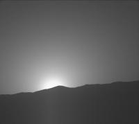
Some rather nice L&R Mastcam images acquired just before sunset on Sol 1880 The mission update refers to these as to get a better idea of the aerosols - dust and water ice
Sadly they are Bayer encoded and jpeg'ed, so beyond the range of my rather basic skill-set. Hopefully someone can do them the justice they deserve and possible acquire another fine animated Martian sunset.
|
|
|
|
|
|
|
Nov 23 2017, 12:58 AM
Post
#168
|
||
|
Senior Member Group: Members Posts: 2428 Joined: 30-January 13 From: Penang, Malaysia. Member No.: 6853 |
A small set of pre-dawn RMI's looking for Frost on sol 1883
One unusual image in the set of four! Maybe some sort of over exposed or a calibration image? I have not encountered one like this before... Any ideas? 
|
|
|
|
|
|
|
Nov 23 2017, 01:36 AM
Post
#169
|
||
 Senior Member Group: Members Posts: 4246 Joined: 17-January 05 Member No.: 152 |
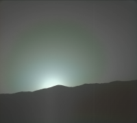
Underexposed, by the look of it.
Here's a quick-and-dirty stab at deBayering that sunset pic:
I've done some heavy Gaussian blurring of the hue and saturation channels. We can't trust the colours here, due to the heavy colour banding/quantization due to the jpegging of the Bayer. In particular I don't buy the grey outer sky regions. But, as always, it's worth it since the raw pds images will be stunning... |
|
|
|
|
|
|
Nov 23 2017, 09:32 AM
Post
#170
|
||
 Senior Member Group: Members Posts: 1084 Joined: 19-February 05 From: Close to Meudon Observatory in France Member No.: 172 |
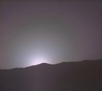
QUOTE (fredk @ Nov 23 2017, 02:36 AM) Underexposed, by the look of it. Here's a quick-and-dirty stab at deBayering that sunset pic: We can't trust the colours here, due to the heavy colour banding/quantization due to the jpegging of the Bayer. In particular I don't buy the grey outer sky regions. But, as always, it's worth it since the raw pds images will be stunning... Dear Fredk, thanks a lot for saving us time for this debayering. Here are the approximate (real) colors I found on your nice image, after using my database and a quick processing. Enjoy
|
|
|
|
|
|
|
Nov 26 2017, 01:02 AM
Post
#171
|
||
|
Senior Member Group: Members Posts: 2428 Joined: 30-January 13 From: Penang, Malaysia. Member No.: 6853 |
Ryan Anderson 'Advocated for ChemCam to use its RMI to take a closer look at an interesting geologic contact on Mt. Sharp during Sol 1885' in the current Mission Update.
Here's my roughly assembled mosaic of the raw RMI's using MS ICE:
|
|
|
|
|
|
|
Nov 26 2017, 12:25 PM
Post
#172
|
|
 Senior Member Group: Members Posts: 1619 Joined: 12-February 06 From: Bergerac - FR Member No.: 678 |
My take on this picture
-------------------- |
|
|
|
|
Nov 27 2017, 08:00 AM
Post
#173
|
||
|
Senior Member Group: Members Posts: 2428 Joined: 30-January 13 From: Penang, Malaysia. Member No.: 6853 |
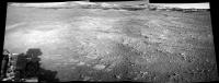
1887 drive, no details yet, but here are the 3 available L-NavCams frames featuring the horizon assembled in MS-ICE, the distant rounded Mesa's and Buttes look really inviting
|
|
|
|
|
|
| Guest_avisolo_* |
Nov 27 2017, 10:17 AM
Post
#174
|
|
Guests |
My take:)

|
|
|
|
|
Nov 27 2017, 12:09 PM
Post
#175
|
|
|
Senior Member Group: Members Posts: 1619 Joined: 12-February 06 From: Bergerac - FR Member No.: 678 |
I played a little with tosol images. So I can make a little Postcard of this nice point of view
-------------------- |
|
|
|
|
Nov 27 2017, 07:01 PM
Post
#176
|
||
|
Solar System Cartographer Group: Members Posts: 10153 Joined: 5-April 05 From: Canada Member No.: 227 |
Nice postcard! These are the reprojected Hazcam images I used to estimate our current position, about 10 m south of the Thanksgiving stop.
Phil
-------------------- ... because the Solar System ain't gonna map itself.
Also to be found posting similar content on https://mastodon.social/@PhilStooke Maps for download (free PD: https://upload.wikimedia.org/wikipedia/comm...Cartography.pdf NOTE: everything created by me which I post on UMSF is considered to be in the public domain (NOT CC, public domain) |
|
|
|
|
|
|
Nov 27 2017, 11:46 PM
Post
#177
|
|
|
Senior Member Group: Members Posts: 1619 Joined: 12-February 06 From: Bergerac - FR Member No.: 678 |
Thanks
Maybe it can be handle to have the full panoramic now all the images are downlinked ^^ 
-------------------- |
|
|
|
|
Nov 28 2017, 12:13 AM
Post
#178
|
||
|
Solar System Cartographer Group: Members Posts: 10153 Joined: 5-April 05 From: Canada Member No.: 227 |
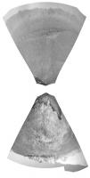
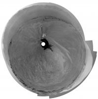
I thought we had moved about 10 m south, but Midnight Planets says 26 m. I'll have to think about that... but Damia's full panorama will be useful. More to follow.
EDIT - sure enough, the full pan tells a different story. Here is a circular projection of that panorama (Thanks, Damia):
I was looking at the white drift to the southeast - I misidentified it on the HiRISE image. Map will be updated momentarily - no, actually, permanently! Phil -------------------- ... because the Solar System ain't gonna map itself.
Also to be found posting similar content on https://mastodon.social/@PhilStooke Maps for download (free PD: https://upload.wikimedia.org/wikipedia/comm...Cartography.pdf NOTE: everything created by me which I post on UMSF is considered to be in the public domain (NOT CC, public domain) |
|
|
|
|
|
|
Nov 28 2017, 10:24 AM
Post
#179
|
||
|
Senior Member Group: Members Posts: 2428 Joined: 30-January 13 From: Penang, Malaysia. Member No.: 6853 |
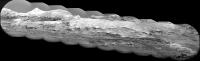
Really stunning terrain captured in this telephoto RMI mosaic of a distant mesa on Mt sharp that Ryan Anderson at USGS/JPL has been monitoring for changes.
Sol 1888, roughly assembled in MS ICE, full size 5655x1704 Link to the Raw images NASA/JPL-CalTech/MSSS/LANL
|
|
|
|
|
|
|
Nov 28 2017, 08:26 PM
Post
#180
|
||
|
Member Group: Members Posts: 122 Joined: 19-June 07 Member No.: 2455 |
QUOTE (PaulH51 @ Nov 28 2017, 03:24 AM) Really stunning terrain captured in this telephoto RMI mosaic of a distant mesa on Mt sharp that Ryan Anderson at USGS/JPL has been monitoring for changes. Sol 1888, roughly assembled in MS ICE, full size 5655x1704 Link to the Raw images NASA/JPL-CalTech/MSSS/LANL
Amazing photo. Oh the nuts are going to go crazy seeing that next to the last image from the right side of this pan with the strange rock that looks like a black shark fin. Can we say Curiosity has now officially jumped the shark? Laughing. |
|
|
|
|
|
|

|
Lo-Fi Version | Time is now: 27th April 2024 - 03:27 AM |
|
RULES AND GUIDELINES Please read the Forum Rules and Guidelines before posting. IMAGE COPYRIGHT |
OPINIONS AND MODERATION Opinions expressed on UnmannedSpaceflight.com are those of the individual posters and do not necessarily reflect the opinions of UnmannedSpaceflight.com or The Planetary Society. The all-volunteer UnmannedSpaceflight.com moderation team is wholly independent of The Planetary Society. The Planetary Society has no influence over decisions made by the UnmannedSpaceflight.com moderators. |
SUPPORT THE FORUM Unmannedspaceflight.com is funded by the Planetary Society. Please consider supporting our work and many other projects by donating to the Society or becoming a member. |
|