Atop/Around the Greenheugh Pediment, Site 79-, sol 2695-3199, 3 Mar 2020-6 Aug 2021 |

  |
Atop/Around the Greenheugh Pediment, Site 79-, sol 2695-3199, 3 Mar 2020-6 Aug 2021 |
 Jan 19 2021, 11:51 PM Jan 19 2021, 11:51 PM
Post
#451
|
|
|
Solar System Cartographer  Group: Members Posts: 10154 Joined: 5-April 05 From: Canada Member No.: 227 |
Yes - might be out a couple of meters but no more.
Looking ahead just 10 days: the beginning of Mars Year 36. Phil -------------------- ... because the Solar System ain't gonna map itself.
Also to be found posting similar content on https://mastodon.social/@PhilStooke Maps for download (free PD: https://upload.wikimedia.org/wikipedia/comm...Cartography.pdf NOTE: everything created by me which I post on UMSF is considered to be in the public domain (NOT CC, public domain) |
 |
 
|
|
Jan 20 2021, 03:02 AM
Post
#452
|
|
 Senior Member Group: Members Posts: 2428 Joined: 30-January 13 From: Penang, Malaysia. Member No.: 6853 |
QUOTE (fredk @ Jan 20 2021, 07:36 AM)  I'm not sure how the positions reported in spice/json files are calculated, but I thought at least in the old days they were usually out somewhat due to wheel slippage etc, so they'd only be expected to get you in the ballpark? Edit: according to Phil, they're very good! I'm still trying to digest the amount of information in Spice, I have a very long way to go. Thanks for all the links and tips guys  I believe you are right re the long term drift in SPICE data, the two sample positions I posted were probably accurate because the end of drive location on sol 3000 became site 85 and is likely the start of a new local level frame (LL), and I'm guessing that's why 3000 and 3005 are accurate as they are relatively close to the LL frame (more on that later). This link opens a Spice kernel directory, sorting the files in date order. In my limited experience, there are usually 4 new files with the UTC date of the drive. I've only got to grips with two so far and that's maybe all I need for now. The file 'msl_surf_rover_runout.bsp' provides computed distance from the landing site (in meters) of the LL frame and the new location in that frame, it even provides the distance from the origin of that frame (in meters) to the new location (point to point). However those distances w.r.t. the landing site do not match Phil's larger scale maps that show distance from the landing site, the SPICE distances are much longer. so I'm treating the SPICE distances as 'suspect' for the time being, until I can understand why they are different if something other than 'drift' The file 'msl_surf_rover_loc_runout.bsp' however provides location values in Planetocentric longitude and latitude. I used those values to identify the locations for 3000 and 3005 on the interactive map as the longitude and latitude of the cursor are reflected at the bottom right of the map. I was hoping to be a little more scientific, but it seems to have worked this time. 'Beginners Luck'? Note all four files are overwritten after each drive, the two files referenced above contain the recent drive data only. I suspect that the complete record is contained in the other two files due to their file size, but I'm not looking for historic data so all is good. I used a text editor to read the files, there's probably a recommended program but a text editor worked for me. The main reason I wanted to try SPICE was to find the elevation after every drive, yes it is reported, but as the distances w.r.t to the landing site don't match Phil's. and the elevation appears to be much higher than the elevations we used to get on the old 'traverse maps'. Anyway to cut this short I wont be using that elevation from SPICE until I can understand why it does not roughly align with the old maps that had elevation annotated on the 1 meter contour lines. |
|
|
|
|
Jan 20 2021, 04:57 AM
Post
#453
|
|
|
Solar System Cartographer Group: Members Posts: 10154 Joined: 5-April 05 From: Canada Member No.: 227 |
Don't rely on my distances from the landing site, because the various error sources are not being systematically corrected in my maps. Can you tell me what figures you get for sol 3005?
Phil -------------------- ... because the Solar System ain't gonna map itself.
Also to be found posting similar content on https://mastodon.social/@PhilStooke Maps for download (free PD: https://upload.wikimedia.org/wikipedia/comm...Cartography.pdf NOTE: everything created by me which I post on UMSF is considered to be in the public domain (NOT CC, public domain) |
|
|
|
|
Jan 20 2021, 06:40 AM
Post
#454
|
|
|
Senior Member Group: Members Posts: 2428 Joined: 30-January 13 From: Penang, Malaysia. Member No.: 6853 |
[quote name='Phil Stooke' date='Jan 20 2021, 12:57 PM' post='249278']
Don't rely on my distances from the landing site, because the various error sources are not being systematically corrected in my maps. Can you tell me what figures you get for sol 3005? Phil Here you go... Sol 3005 data - directly from file 'msl_surf_rover_runout.bsp (dated 19 Jan 2021) -8588.606 m (assuming this is South of landing site) -2639.857 m (assuming this is West of landing site) -472.771 m (assuming this is Elevation above landing site) It also goes on to give the following rover position relative to site 85 (in meters) as:- -11.116 m (assuming this is south of site 85 - Sol 3000) 76.153 m (assuming this is East of site 85 - Sol 3000) -2.044 m (assuming this is the change in elevation with site 85 - Sol 3000) Hope that helps |
|
|
|
|
Jan 20 2021, 10:23 AM
Post
#455
|
|
|
Senior Member Group: Members Posts: 2428 Joined: 30-January 13 From: Penang, Malaysia. Member No.: 6853 |
An extremely interesting paper about Curiosity's wheels and what tests were conducted in the Mars Yard...
'Rimmed Wheel Performance on the Mars Science Laboratory Scarecrow Rover' PDF |
|
|
|
|
Jan 20 2021, 12:02 PM
Post
#456
|
||
|
Senior Member Group: Members Posts: 2822 Joined: 22-April 05 From: Ridderkerk, Netherlands Member No.: 353 |
The NAVcam L view on Sol 3005.
Jan van Driel
|
|
|
|
|
|
|
Jan 20 2021, 12:54 PM
Post
#457
|
||
|
Junior Member Group: Members Posts: 95 Joined: 11-January 07 From: Amsterdam Member No.: 1584 |
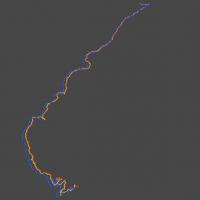
QUOTE (PaulH51 @ Jan 20 2021, 07:40 AM) Sol 3005 data - directly from file 'msl_surf_rover_runout.bsp (dated 19 Jan 2021) -8588.606 m (assuming this is South of landing site) -2639.857 m (assuming this is West of landing site) -472.771 m (assuming this is Elevation above landing site) I get the exact same values from the telemetry kernels ('msl_surf_rover_tlm.bsp and 'msl_surf_rover_runout.bsp) , which Marslife.org is using. The other two (loc) kernels give values that better match with the positions given by NASA's 'Where is curiosity?' map. Here is a quick comparison made in Blender that shows the differences between telemetry (blue) and position (red) kernels. The yellow line is the localized csv from PDS.
-------------------- |
|
|
|
|
|
|
Jan 20 2021, 01:05 PM
Post
#458
|
||
|
Senior Member Group: Members Posts: 2428 Joined: 30-January 13 From: Penang, Malaysia. Member No.: 6853 |
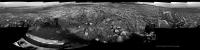
Sol 3005: L-MastCam - Drive direction mosaic. Closing in on the Sulfate bearing unit.
(Raw images assembled in MS-ICE, no additional processing)
|
|
|
|
|
|
|
Jan 20 2021, 06:31 PM
Post
#459
|
|
 Senior Member Group: Members Posts: 4246 Joined: 17-January 05 Member No.: 152 |
QUOTE (phase4 @ Jan 20 2021, 01:54 PM) I get the exact same values from the telemetry kernels ('msl_surf_rover_tlm.bsp and 'msl_surf_rover_runout.bsp) , which Marslife.org is using. The other two (loc) kernels give values that better match with the positions given by NASA's 'Where is curiosity?' map. Thanks for plotting those. The v2 json files match the offsets from the site origin in the tlm spice files. On the other hand, the landing-relative x,y in locations.xml don't agree with tlm spice - instead they give x=-8523.42644874959, y=-2480.898619588952. This is NE of the tlm location and judging from your plot may correspond to the loc spice file positions (red curve). Presumably the PDS values are more accurate, so we should use spice loc or locations.xml rather than spice tlm? This probably only really matters for landing-relative coordinates, and sol-sol offsets are probably very similar for both. |
|
|
|
|
Jan 21 2021, 12:04 AM
Post
#460
|
|
|
Senior Member Group: Members Posts: 2428 Joined: 30-January 13 From: Penang, Malaysia. Member No.: 6853 |
QUOTE (Phil Stooke @ Jan 20 2021, 03:14 AM) That puts us just about on the boundary with the next quadrangle. I don't know its name yet. Phil Here is the new quadrangle name "Nontron" LINK |
|
|
|
|
Jan 21 2021, 04:50 PM
Post
#461
|
|
 Member Group: Members Posts: 809 Joined: 3-June 04 From: Brittany, France Member No.: 79 |
QUOTE (PaulH51 @ Jan 21 2021, 01:04 AM) Here is the new quadrangle name "Nontron" LINK Finally, french names (with weird pronunciations) 
-------------------- |
|
|
|
|
Jan 21 2021, 05:30 PM
Post
#462
|
|
|
Senior Member Group: Members Posts: 1074 Joined: 21-September 07 From: Québec, Canada Member No.: 3908 |
French pronunciation here
|
|
|
|
|
Jan 21 2021, 10:36 PM
Post
#463
|
||
|
Solar System Cartographer Group: Members Posts: 10154 Joined: 5-April 05 From: Canada Member No.: 227 |
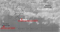
The coordinate discussion is very interesting. Here is my current overview map with the SPICE and locations.xml positions for sol 3005 added.
My map locations are plotted relative to the base map, not to coordinates, so any error in my maps is in the registration between the base map and the grid. Errors can arise from a variety of things including a slightly incorrect scaling, differences in map projection (specifically central longitude) between individual HiRISE ortho-images, and updates to HiRISE registration with Martian coordinates over time, if any, all propagating from the landing to today. My map grids can be used to measure local positions and distances but not positions relative to the landing site if precision is required. But you can also see that there are two choices for any correction you might want to make, so it's not really clear which correction to make. Anyway, I will not be changing my maps, but this gives me something to add to the intro to my next atlas. Just to make it clear, the SPICE and XML positions are not saying 'Curiosity is in the Sands of Forvie' where those red squares are placed. They are saying 'the whole map including the base image and the traverse should be shifted over here'. Phil -------------------- ... because the Solar System ain't gonna map itself.
Also to be found posting similar content on https://mastodon.social/@PhilStooke Maps for download (free PD: https://upload.wikimedia.org/wikipedia/comm...Cartography.pdf NOTE: everything created by me which I post on UMSF is considered to be in the public domain (NOT CC, public domain) |
|
|
|
|
|
|
Jan 21 2021, 11:07 PM
Post
#464
|
|
|
Senior Member Group: Members Posts: 2428 Joined: 30-January 13 From: Penang, Malaysia. Member No.: 6853 |
QUOTE (Phil Stooke @ Jan 22 2021, 06:36 AM) The coordinate discussion is very interesting... Thanks for the clarification Phil I guess this throws some light on the issues that Google Earth experienced when they used to plot Curiosity's path on Mars, it was always offset. I particularly recall seeing the rover smack in the middle of Namib dune, thankfully Fernando came to my rescue for using Google Earth. |
|
|
|
|
Jan 21 2021, 11:10 PM
Post
#465
|
|
|
Senior Member Group: Members Posts: 2511 Joined: 13-September 05 Member No.: 497 |
QUOTE (fredk @ Jan 20 2021, 10:31 AM) Presumably the PDS values are more accurate... See https://pds-imaging.jpl.nasa.gov/data/msl/M...CES_PDS_SIS.PDF for an extensive (61 pages!) discussion of how localization is done. Presumably if you overlaid the localization data on the map data, all from that volume, it would be close? I've never tried it. -------------------- Disclaimer: This post is based on public information only. Any opinions are my own.
|
|
|
|
|

|
Lo-Fi Version | Time is now: 2nd May 2024 - 02:15 AM |
|
RULES AND GUIDELINES Please read the Forum Rules and Guidelines before posting. IMAGE COPYRIGHT |
OPINIONS AND MODERATION Opinions expressed on UnmannedSpaceflight.com are those of the individual posters and do not necessarily reflect the opinions of UnmannedSpaceflight.com or The Planetary Society. The all-volunteer UnmannedSpaceflight.com moderation team is wholly independent of The Planetary Society. The Planetary Society has no influence over decisions made by the UnmannedSpaceflight.com moderators. |
SUPPORT THE FORUM Unmannedspaceflight.com is funded by the Planetary Society. Please consider supporting our work and many other projects by donating to the Society or becoming a member. |
|