Continuing into Glenelg, Leaving Rocknest behind, sols 102-166 (Nov 18 2012-Jan 23, 2013) |

  |
Continuing into Glenelg, Leaving Rocknest behind, sols 102-166 (Nov 18 2012-Jan 23, 2013) |
 Jan 4 2013, 06:44 PM Jan 4 2013, 06:44 PM
Post
#511
|
|
 Member  Group: Members Posts: 408 Joined: 3-August 05 Member No.: 453 |
QUOTE (Phil Stooke @ Jan 2 2013, 12:10 PM)  One approach - paste one image over another. Invert the shading of the top one (make it a negative of itself). Make the top one 50% transparent. If no change the result is a flat grey. And change including shadows will show up light or dark. Major contrast stretch might help. Did that for sols 120-146; still nothing obvious or indeed anything even vaguely possible that persisted for more than one frame. I tested the algorithm below with some dummy +1/-1% brightness "dust devil" data which did then show up quite easily: CODE convert a.JPG -colorspace Gray \( b.JPG -colorspace Gray -negate \) \ -compose Plus -composite -modulate 50 -blur 9 -auto-level out.jpg Airbag PS No idea why the code box above is so big. |
 |
 
|
|
Jan 4 2013, 09:57 PM
Post
#512
|
|
 Senior Member Group: Moderator Posts: 3431 Joined: 11-August 04 From: USA Member No.: 98 |
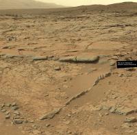
And we have a name: "Snake River". http://www.jpl.nasa.gov/news/news.php?release=2013-003
|
|
|
|
|
Jan 4 2013, 10:42 PM
Post
#513
|
|
|
Member Group: Members Posts: 384 Joined: 4-January 07 Member No.: 1555 |
QUOTE (Gerald @ Jan 3 2013, 04:26 PM) ...Fluvial or aeolian origin may still be options. Fluvial may be more likely than lacustrine. But I think, the impact hypotheses will become less likely. For non-geologists, I point out that MSL is exploring a thick sequence of layered rocks, presumably formed over a long period of time by a variety of processes. Each layer (even a thin layer) could have been formed by a process distinct from whatever formed the layers above and below it, and owing to, say, erosion and reworking, any given layer might have formed by a combination of processes. Given the impact- and volcanism-dominated history of early Mars, one would certainly expect to find layers formed by distant impacts (e.g., blast beds) or volcanoes (e.g., ash beds) inter-layered with rocks formed by other processes. -dburt |
|
|
|
|
Jan 4 2013, 11:14 PM
Post
#514
|
|
|
Senior Member Group: Members Posts: 3516 Joined: 4-November 05 From: North Wales Member No.: 542 |
Apologies for not being fully up to speed but a one word answer would help me here. Does your scenario for early Mars include or exclude the possibility of a lake of water in Gale crater?
|
|
|
|
|
Jan 4 2013, 11:14 PM
Post
#515
|
|||
 Member Group: Members Posts: 215 Joined: 23-October 12 From: Russia Member No.: 6725 |
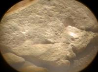
Colored ChemCam on Sol 147 and location of shots in Snake River
Attached thumbnail(s)
-------------------- My blog on Patreon
|
||
|
|
|
||
|
Jan 5 2013, 12:23 AM
Post
#516
|
|
 Senior Member Group: Members Posts: 1619 Joined: 12-February 06 From: Bergerac - FR Member No.: 678 |
Sol 147 Navcam pan. Get ready for some drilling ?
-------------------- |
|
|
|
|
Jan 5 2013, 01:11 AM
Post
#517
|
|
|
Senior Member Group: Members Posts: 2998 Joined: 30-October 04 Member No.: 105 |
QUOTE (DonBurt) Each layer (even a thin layer) could have been formed by a process distinct from whatever formed the layers above and below it, and owing to, say, erosion and reworking, any given layer might have formed by a combination of processes. Absolutely. On Mars, the stratigraphy is exceedingly complex and most depositional, weathering and erosional processes, although familiar, are quite alien in their details.QUOTE (ngunn) a one word answer would help me here... Maybe. --Bill -------------------- |
|
|
|
|
Jan 5 2013, 02:01 AM
Post
#518
|
|
|
Member Group: Members Posts: 384 Joined: 4-January 07 Member No.: 1555 |
QUOTE (ngunn @ Jan 4 2013, 04:14 PM) ...a one word answer would help me here. Does your scenario for early Mars include or exclude the possibility of a lake of water in Gale crater? Sorry, to the extent that this was addressed to me, no opinion and no particular scenario. As a geologist, I merely try to interpret the rocks as they are imaged. So far MSL has imaged no rocks that look like lake beds, but the mission is just beginning. Bill Harris just summarized this matter far more succinctly than I ever could. -dburt |
|
|
|
|
Jan 5 2013, 03:19 AM
Post
#519
|
||
|
Solar System Cartographer Group: Members Posts: 10159 Joined: 5-April 05 From: Canada Member No.: 227 |
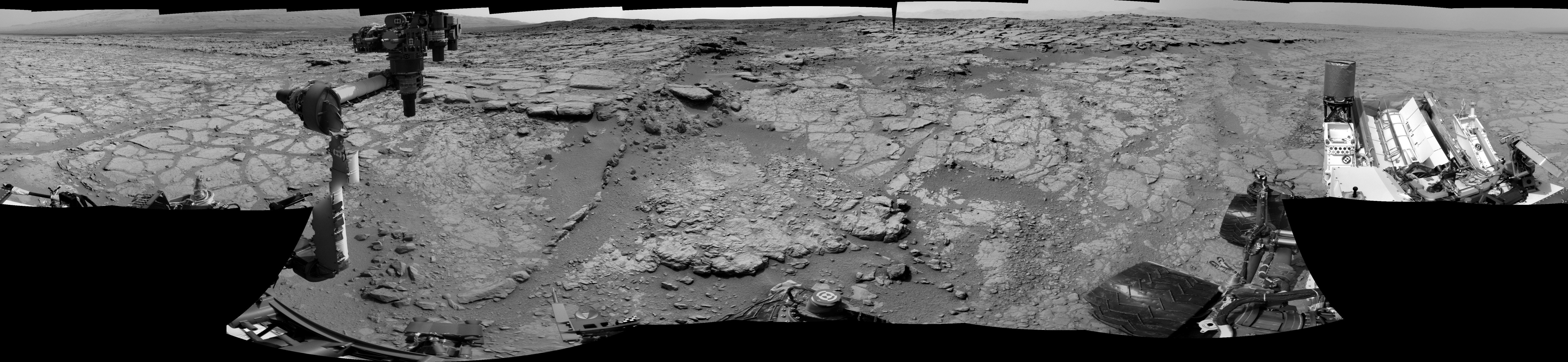
At last! I'm back home after my holiday travels - and/or travails - so i can get back to work on Mars. Here is Ant103's new pan in circular format. I will be updating the route map when I get back to my office, where I can call it 'work'.
Phil
PS - I really like the color chemcam images. -------------------- ... because the Solar System ain't gonna map itself.
Also to be found posting similar content on https://mastodon.social/@PhilStooke Maps for download (free PD: https://upload.wikimedia.org/wikipedia/comm...Cartography.pdf NOTE: everything created by me which I post on UMSF is considered to be in the public domain (NOT CC, public domain) |
|
|
|
|
|
|
Jan 5 2013, 09:06 AM
Post
#520
|
|
|
Senior Member Group: Members Posts: 3516 Joined: 4-November 05 From: North Wales Member No.: 542 |
QUOTE (Bill Harris @ Jan 5 2013, 01:11 AM) Maybe. QUOTE (dburt @ Jan 5 2013, 02:01 AM) no opinion and no particular scenario. Thanks both. |
|
|
|
|
Jan 5 2013, 11:19 PM
Post
#521
|
||
|
Member Group: Members Posts: 408 Joined: 3-August 05 Member No.: 453 |
Sols 137-141 MastCam 100 pano now almost complete with some full-size stragglers arriving today. Just two more!
Airbag |
|
|
|
|
|
|
Jan 6 2013, 04:48 AM
Post
#522
|
|
|
Member Group: Members Posts: 408 Joined: 3-August 05 Member No.: 453 |
...and the sol 137 MastCam34 360 degree pano's last two full-size images arrived today; this updated QT pano starts off pointing at the current Sol 147 view:
 MSL_sol_137_ML_QT_pano_v2.mov ( 947.26K )
Number of downloads: 404
MSL_sol_137_ML_QT_pano_v2.mov ( 947.26K )
Number of downloads: 404Airbag |
|
|
|
|
Jan 6 2013, 05:17 AM
Post
#523
|
||
|
Member Group: Members Posts: 408 Joined: 3-August 05 Member No.: 453 |
...and for traditionalists, the sol 137 MastCam34 (pano) view of this same current sol 147 area in color and high res (shame that that one image is still missing...):
Airbag |
|
|
|
|
|
|
Jan 6 2013, 06:27 AM
Post
#524
|
|
|
Junior Member Group: Members Posts: 87 Joined: 17-May 08 Member No.: 4114 |
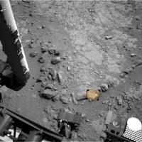
Impressive tail on this rock from sol 138 http://mars.jpl.nasa.gov/msl-raw-images/ms...6000E2_DXXX.jpg

|
|
|
|
|
Jan 6 2013, 12:55 PM
Post
#525
|
|
 Member Group: Members Posts: 691 Joined: 21-December 07 From: Clatskanie, Oregon Member No.: 3988 |
As Airbag said, the Sol-137 Left Mastcam is now complete.
 My version has been reduced 25 percent because Flickr fails to upload the full version. Grr 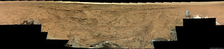 EDIT: Added some sky 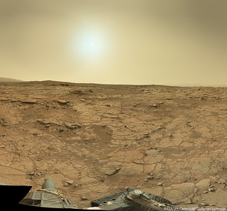
|
|
|
|
|

|
Lo-Fi Version | Time is now: 7th May 2024 - 01:55 AM |
|
RULES AND GUIDELINES Please read the Forum Rules and Guidelines before posting. IMAGE COPYRIGHT |
OPINIONS AND MODERATION Opinions expressed on UnmannedSpaceflight.com are those of the individual posters and do not necessarily reflect the opinions of UnmannedSpaceflight.com or The Planetary Society. The all-volunteer UnmannedSpaceflight.com moderation team is wholly independent of The Planetary Society. The Planetary Society has no influence over decisions made by the UnmannedSpaceflight.com moderators. |
SUPPORT THE FORUM Unmannedspaceflight.com is funded by the Planetary Society. Please consider supporting our work and many other projects by donating to the Society or becoming a member. |
|