LADEE |

  |
LADEE |
 Feb 1 2014, 11:08 AM Feb 1 2014, 11:08 AM
Post
#31
|
|
 Member  Group: Members Posts: 547 Joined: 1-May 06 From: Scotland (Ecosse, Escocia) Member No.: 759 |
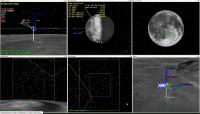
LRO photographed LADEE passing underneath it. They also managed to reconstruct a better image from the blur, showing features on the spacecraft. Very nice...
Ladee from LRO |
 |
 
|
|
Apr 2 2014, 03:39 AM
Post
#32
|
|
|
Senior Member Group: Members Posts: 2082 Joined: 13-February 10 From: Ontario Member No.: 5221 |
Teleconference this Thursday about the extended science and EOM.
http://www.nasa.gov/ames/nasa-to-host-medi...ed-moon-impact/ |
|
|
|
|
Apr 15 2014, 11:28 PM
Post
#33
|
|
|
Solar System Cartographer Group: Members Posts: 10153 Joined: 5-April 05 From: Canada Member No.: 227 |
LADEE tweeted that it survived the eclipse.
Phil -------------------- ... because the Solar System ain't gonna map itself.
Also to be found posting similar content on https://mastodon.social/@PhilStooke Maps for download (free PD: https://upload.wikimedia.org/wikipedia/comm...Cartography.pdf NOTE: everything created by me which I post on UMSF is considered to be in the public domain (NOT CC, public domain) |
|
|
|
|
Apr 15 2014, 11:38 PM
Post
#34
|
|
|
Founder Group: Chairman Posts: 14432 Joined: 8-February 04 Member No.: 1 |
There's a great display that will autonomously flick between realtime telemetry driven and predicted trajectory
http://ladeestk.sci.gsfc.nasa.gov/preview.cgi |
|
|
|
|
Apr 16 2014, 01:31 PM
Post
#35
|
||
 Senior Member Group: Members Posts: 2492 Joined: 15-January 05 From: center Italy Member No.: 150 |
QUOTE (djellison @ Apr 15 2014, 11:38 PM)  There's a great display that will autonomously flick between realtime telemetry driven and predicted trajectory Cool indeed! Until this morning (08 UT) periaxis was a mere 5.19 km above nominal surface:
Now connection appear impossible for me (timeout expiring), do someone knows more recen informations? NOTE: I was able to re-connect few minutes ago, exactly near the new periaxis! at 15:35 it was 5.29km (slightly increased) -------------------- I always think before posting! - Marco -
|
|
|
|
|
|
|
Apr 18 2014, 09:54 AM
Post
#36
|
|
|
Junior Member Group: Members Posts: 39 Joined: 26-March 09 From: Cornwall Member No.: 4697 |
It's down, no details from NASA yet but someone's tweeted Sundman crater.
|
|
|
|
|
Apr 18 2014, 01:01 PM
Post
#37
|
|
|
Solar System Cartographer Group: Members Posts: 10153 Joined: 5-April 05 From: Canada Member No.: 227 |
Yes, Thursday evening California time, Friday morning UT. Sundman crater is just north of Orientale, near Einstein crater and only just on the far side. Details were from Astrogator.
Phil -------------------- ... because the Solar System ain't gonna map itself.
Also to be found posting similar content on https://mastodon.social/@PhilStooke Maps for download (free PD: https://upload.wikimedia.org/wikipedia/comm...Cartography.pdf NOTE: everything created by me which I post on UMSF is considered to be in the public domain (NOT CC, public domain) |
|
|
|
|
Sep 18 2014, 07:20 PM
Post
#38
|
|
|
Solar System Cartographer Group: Members Posts: 10153 Joined: 5-April 05 From: Canada Member No.: 227 |
I added LADEE (extreme right edge) and Chang'E 3 to my fake olde-time lunar map with landing and impact sites:
http://publish.uwo.ca/~pjstooke/vehiculum.jpg Phil -------------------- ... because the Solar System ain't gonna map itself.
Also to be found posting similar content on https://mastodon.social/@PhilStooke Maps for download (free PD: https://upload.wikimedia.org/wikipedia/comm...Cartography.pdf NOTE: everything created by me which I post on UMSF is considered to be in the public domain (NOT CC, public domain) |
|
|
|
|
Oct 28 2014, 08:20 PM
Post
#39
|
||
|
Solar System Cartographer Group: Members Posts: 10153 Joined: 5-April 05 From: Canada Member No.: 227 |
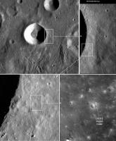
LADEE imaged by LROC.
http://lroc.sese.asu.edu/posts/822 Here's a finder image to locate the site. Phil
-------------------- ... because the Solar System ain't gonna map itself.
Also to be found posting similar content on https://mastodon.social/@PhilStooke Maps for download (free PD: https://upload.wikimedia.org/wikipedia/comm...Cartography.pdf NOTE: everything created by me which I post on UMSF is considered to be in the public domain (NOT CC, public domain) |
|
|
|
|
|
|
Jun 18 2015, 06:24 PM
Post
#40
|
|
|
Senior Member Group: Members Posts: 2082 Joined: 13-February 10 From: Ontario Member No.: 5221 |
Looks like an old mystery may have been solved: http://www.nature.com/nature/journal/v522/...ature14479.html
|
|
|
|
|
Jul 7 2015, 09:46 AM
Post
#41
|
|
 Newbie Group: Members Posts: 1 Joined: 6-July 15 Member No.: 7557 |
QUOTE (Explorer1 @ Jun 18 2015, 07:24 PM) Looks like an old mystery may have been solved: http://www.nature.com/nature/journal/v522/...ature14479.html interesting but i don't think so... is there any additional source? -------------------- |
|
|
|
|
Jul 7 2015, 12:01 PM
Post
#42
|
|
|
Solar System Cartographer Group: Members Posts: 10153 Joined: 5-April 05 From: Canada Member No.: 227 |
It's Nature... it is an additional source all by itself.
Perhaps you would care to explain the reason for your scepticism. It all seems pretty reasonable to me. Phil -------------------- ... because the Solar System ain't gonna map itself.
Also to be found posting similar content on https://mastodon.social/@PhilStooke Maps for download (free PD: https://upload.wikimedia.org/wikipedia/comm...Cartography.pdf NOTE: everything created by me which I post on UMSF is considered to be in the public domain (NOT CC, public domain) |
|
|
|
|
Jan 15 2016, 08:20 AM
Post
#43
|
|
 Senior Member Group: Members Posts: 1729 Joined: 3-August 06 From: 43° 35' 53" N 1° 26' 35" E Member No.: 1004 |
one new paper on LADEE results in today's Science (and it appears to be in open access!):
How surface composition and meteoroid impacts mediate sodium and potassium in the lunar exosphere QUOTE Despite being trace constituents of the lunar exosphere, sodium and potassium are the most readily observed species due to their bright line emission. Measurements of these species by the Ultraviolet and Visible Spectrometer (UVS) on the Lunar Atmosphere and Dust Environment Explorer (LADEE) have revealed unambiguous temporal and spatial variations indicative of a strong role for meteoroid bombardment and surface composition in determining the composition and local time dependence of the Moons exosphere. Observations show distinct lunar day (monthly) cycles for both species as well as an annual cycle for sodium. The first continuous measurements for potassium show a more repeatable variation across lunations and an enhancement over KREEP (Potassium Rare Earth Elements and Phosphorus) surface regions, revealing a strong dependence on surface composition. see also the perspective article (also in open access): Sampling the Moon's atmosphere QUOTE In H. G. Wells' 1901 science fiction classic The First Men in the Moon, two protagonists, English businessman Mr. Bedford and the eccentric physicist Dr. Cavor, knock back a special enervating concoction designed to expand their lungs, followed by the requisite fortifying brandy, before venturing onto the Moon's surface to breathe the rarefied lunar atmosphere. Even more tenuous than Wells' imagined environment, the lunar exosphere is an atmosphere so thin that atoms never collide, bounded on one side by the lunar surface and extending thousands of kilometers out into space. This low-density envelope results from a balance among the influx of material from the Sun, outgassing from the Moon's interior, delivery from meteoritic bombardment, and the loss of material to space as well as recycling in the lunar surface (see the figure). The precise formula for the formation of the lunar exosphere is unknown, but recent data from orbital spacecraft are being used to delineate the relative contributions from different processes. On page 249 of this issue, Colaprete et al. (1) report measurements of sodium and potassium (Na and K) in the lunar exosphere based on observations from the Ultraviolet and Visible Spectrometer (UVS) aboard NASA's Lunar Atmosphere and Dust Environment Explorer (LADEE), which acquired continuous dayside and nightside measurements of exospheric Na and K over multiple lunar orbits.
|
|
|
|
|
Aug 29 2016, 02:36 PM
Post
#44
|
||
|
Solar System Cartographer Group: Members Posts: 10153 Joined: 5-April 05 From: Canada Member No.: 227 |
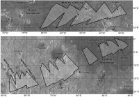
Looking back at this thread, I didn't see any mention of the LADEE star tracker images. I have found three short GIF sequences shot by the star trackers:
http://www.nasa.gov/ames/ladee-star-tracke...canelli-craters https://www.nasa.gov/ames/ladee-project-scientist-update/ http://www.americaspace.com/?p=59288 If anybody knows of others, please post them! The first two show the surface illuminated by Earthshine. One has locations identified, the other doesn't. I have located them on these maps. Phil
-------------------- ... because the Solar System ain't gonna map itself.
Also to be found posting similar content on https://mastodon.social/@PhilStooke Maps for download (free PD: https://upload.wikimedia.org/wikipedia/comm...Cartography.pdf NOTE: everything created by me which I post on UMSF is considered to be in the public domain (NOT CC, public domain) |
|
|
|
|
|
|

|
Lo-Fi Version | Time is now: 28th April 2024 - 12:22 PM |
|
RULES AND GUIDELINES Please read the Forum Rules and Guidelines before posting. IMAGE COPYRIGHT |
OPINIONS AND MODERATION Opinions expressed on UnmannedSpaceflight.com are those of the individual posters and do not necessarily reflect the opinions of UnmannedSpaceflight.com or The Planetary Society. The all-volunteer UnmannedSpaceflight.com moderation team is wholly independent of The Planetary Society. The Planetary Society has no influence over decisions made by the UnmannedSpaceflight.com moderators. |
SUPPORT THE FORUM Unmannedspaceflight.com is funded by the Planetary Society. Please consider supporting our work and many other projects by donating to the Society or becoming a member. |
|