Apollo Sites from LRO |

  |
Apollo Sites from LRO |
 Jul 17 2009, 02:52 PM Jul 17 2009, 02:52 PM
Post
#1
|
||||
|
Founder  Group: Chairman Posts: 14432 Joined: 8-February 04 Member No.: 1 |
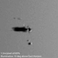
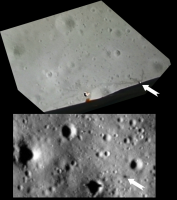
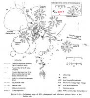
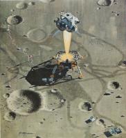
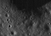
Thought this deserved a new thread- we can't talk about EVERY LRO target in the one thread
 I made a mistake in this one - I didn't include the thruster plume guards. My MER/MPF simulation for HiRISE seemed to come out about right - so fingers crossed that this will be there or there abouts as well. Still in a comissioning phase, something of a slant angle - I'd expect approx 1.5m/pixel if it's at the 120km figure mentioned earlier.
Attached thumbnail(s)
|
|||
 |
 
|
|||
|
Jul 17 2009, 04:10 PM
Post
#2
|
|
|
Solar System Cartographer Group: Members Posts: 10164 Joined: 5-April 05 From: Canada Member No.: 227 |
-------------------- ... because the Solar System ain't gonna map itself.
Also to be found posting similar content on https://mastodon.social/@PhilStooke Maps for download (free PD: https://upload.wikimedia.org/wikipedia/comm...Cartography.pdf NOTE: everything created by me which I post on UMSF is considered to be in the public domain (NOT CC, public domain) |
|
|
|
|
Jul 17 2009, 04:21 PM
Post
#3
|
|
 Senior Member Group: Members Posts: 1729 Joined: 3-August 06 From: 43° 35' 53" N 1° 26' 35" E Member No.: 1004 |
LRO Sees Apollo Landing Sites
I had been expecting something better... |
|
|
|
|
Jul 17 2009, 04:23 PM
Post
#4
|
|
|
Solar System Cartographer Group: Members Posts: 10164 Joined: 5-April 05 From: Canada Member No.: 227 |
And more:
http://www.nasa.gov/mission_pages/LRO/mult...pollosites.html (same as above) - remember the instrument's still being calibrated and the final orbit will be half the height, or even less. Phil -------------------- ... because the Solar System ain't gonna map itself.
Also to be found posting similar content on https://mastodon.social/@PhilStooke Maps for download (free PD: https://upload.wikimedia.org/wikipedia/comm...Cartography.pdf NOTE: everything created by me which I post on UMSF is considered to be in the public domain (NOT CC, public domain) |
|
|
|
|
Jul 17 2009, 04:26 PM
Post
#5
|
|
 Junior Member Group: Members Posts: 87 Joined: 9-November 07 Member No.: 3958 |
Are those LRV tracks from Apollo 17? They look about right for one of the EVAs, headed east and then curving north around the crater, but I can't put my mouse on a large-enough scale traverse map to be sure that's the right place.
|
|
|
|
|
Jul 17 2009, 04:27 PM
Post
#6
|
|
 The Poet Dude Group: Moderator Posts: 5551 Joined: 15-March 04 From: Kendal, Cumbria, UK Member No.: 60 |
Expected better? Sorry there are no individual footprints to be seen for you...!
 These are AMAZING pictures when you think of what they represent. Better will follow. Let's enjoy these for now! :-) -------------------- |
|
|
|
|
Jul 17 2009, 04:29 PM
Post
#7
|
|
 Newbie Group: Members Posts: 4 Joined: 24-June 09 Member No.: 4837 |
Hello everybody!
Finally the images arrived! Do you think we could expect any greater resolution, maybe through the lroc image browser? -------------------- |
|
|
|
|
Jul 17 2009, 04:30 PM
Post
#8
|
|
|
Senior Member Group: Members Posts: 1729 Joined: 3-August 06 From: 43° 35' 53" N 1° 26' 35" E Member No.: 1004 |
QUOTE (Stu @ Jul 17 2009, 06:27 PM)  Better will follow. Let's enjoy these for now! :-) yes of course! I just expected to see for example rovers and instruments... |
|
|
|
|
Jul 17 2009, 04:39 PM
Post
#9
|
||
|
Junior Member Group: Members Posts: 41 Joined: 12-April 06 Member No.: 738 |
Wow, this is so cool!
I don't know, I suspect the LRV of Apollo 17 should be a bit less south, it was finally parked about 154 meters east of the LM. My guess yet:
Attached thumbnail(s)
|
|
|
|
|
|
|
Jul 17 2009, 04:43 PM
Post
#10
|
||
|
Founder Group: Chairman Posts: 14432 Joined: 8-February 04 Member No.: 1 |
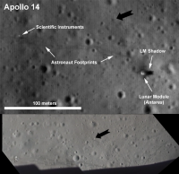
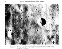
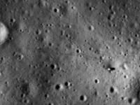
I was expecting a bit better. You can see the seismometer's western solar array just about. It's not map-projected, and calibration hasn't kicked in to fix that interlacing-look to the pictures.
MUCH better is to come - that's for sure. This is roughly with the same illumination.
Attached thumbnail(s)
|
|
|
|
|
|
|
Jul 17 2009, 04:45 PM
Post
#11
|
|
|
Founder Group: Chairman Posts: 14432 Joined: 8-February 04 Member No.: 1 |
QUOTE (Tubo @ Jul 17 2009, 05:29 PM) Do you think we could expect any greater resolution, maybe through the lroc image browser? No. These thumbnails are at full resolution. We have to wait for the spacecraft to get into its final orbit before we go from these 1.2-ish m/pixel images to 50cm/pixel. |
|
|
|
|
Jul 17 2009, 04:46 PM
Post
#12
|
||
|
Solar System Cartographer Group: Members Posts: 10164 Joined: 5-April 05 From: Canada Member No.: 227 |
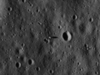
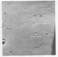
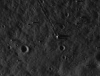
Apollo 15 - certainly see the tracks all around ALSEP.
Phil
-------------------- ... because the Solar System ain't gonna map itself.
Also to be found posting similar content on https://mastodon.social/@PhilStooke Maps for download (free PD: https://upload.wikimedia.org/wikipedia/comm...Cartography.pdf NOTE: everything created by me which I post on UMSF is considered to be in the public domain (NOT CC, public domain) |
|
|
|
|
|
|
Jul 17 2009, 04:48 PM
Post
#13
|
|
|
Solar System Cartographer Group: Members Posts: 10164 Joined: 5-April 05 From: Canada Member No.: 227 |
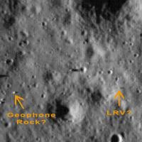
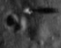
Fordprefect - no, Geophone rock is casting the shadow just above left of your rock.
Phil -------------------- ... because the Solar System ain't gonna map itself.
Also to be found posting similar content on https://mastodon.social/@PhilStooke Maps for download (free PD: https://upload.wikimedia.org/wikipedia/comm...Cartography.pdf NOTE: everything created by me which I post on UMSF is considered to be in the public domain (NOT CC, public domain) |
|
|
|
|
Jul 17 2009, 04:55 PM
Post
#14
|
|
|
Merciless Robot Group: Admin Posts: 8784 Joined: 8-December 05 From: Los Angeles Member No.: 602 |
It'll get better, but for now I'm really happy just to see these old friends from my youth again.
I'm only disappointed that they haven't snapped A12 & Surveyor 3 yet, but apparently that's gonna happen in a few weeks. -------------------- A few will take this knowledge and use this power of a dream realized as a force for change, an impetus for further discovery to make less ancient dreams real.
|
|
|
|
|
Jul 17 2009, 04:57 PM
Post
#15
|
||
|
Solar System Cartographer Group: Members Posts: 10164 Joined: 5-April 05 From: Canada Member No.: 227 |
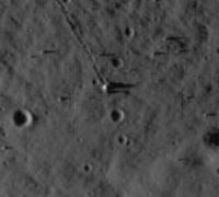
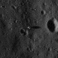
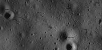
Here's Apollo 17, first quick look.
Phil
The LRV location is a bit vague... is it possible it's the object with a shadow just above my 'LRV' text? -------------------- ... because the Solar System ain't gonna map itself.
Also to be found posting similar content on https://mastodon.social/@PhilStooke Maps for download (free PD: https://upload.wikimedia.org/wikipedia/comm...Cartography.pdf NOTE: everything created by me which I post on UMSF is considered to be in the public domain (NOT CC, public domain) |
|
|
|
|
|
|
Jul 17 2009, 05:06 PM
Post
#16
|
||
 Lord Of The Uranian Rings Group: Members Posts: 798 Joined: 18-July 05 From: Plymouth, UK Member No.: 437 |
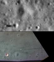
LRO view of Apollo 15 compared to mosaic made from ascent footage - the white arrow points to a piece of the descent stage insulation that was blown off during liftoff.
-------------------- |
|
|
|
|
|
|
Jul 17 2009, 05:08 PM
Post
#17
|
|
|
Newbie Group: Members Posts: 4 Joined: 24-June 09 Member No.: 4837 |
So far it seems that the Apollo 14 Landing site shot has got the greatest resolution, aren't the MET tracks the ones visible?
-------------------- |
|
|
|
|
Jul 17 2009, 05:10 PM
Post
#18
|
|
|
Founder Group: Chairman Posts: 14432 Joined: 8-February 04 Member No.: 1 |
A combination of shuffling astronauts and dragged met.
|
|
|
|
|
Jul 17 2009, 05:11 PM
Post
#19
|
||
|
Solar System Cartographer Group: Members Posts: 10164 Joined: 5-April 05 From: Canada Member No.: 227 |
Now you can zoomify the whole images at the LROC site - here's the Apollo 17 Station 6 boulder:
(Zoomify uses a compressed image so there are artifacts) Phil -------------------- ... because the Solar System ain't gonna map itself.
Also to be found posting similar content on https://mastodon.social/@PhilStooke Maps for download (free PD: https://upload.wikimedia.org/wikipedia/comm...Cartography.pdf NOTE: everything created by me which I post on UMSF is considered to be in the public domain (NOT CC, public domain) |
|
|
|
|
|
|
Jul 17 2009, 05:11 PM
Post
#20
|
|
 Member Group: Members Posts: 150 Joined: 3-June 08 From: McLean, VA Member No.: 4177 |
YeeHAHHH!!
Great stuff! I make out the '11 site LM at about 200 pixels, some of the others, slightly less. You can clearly see the nozzle shadow going to the bulk of the stage with the plume deflectors very light. I'm trying to convince myself I see the flag - more to study. And they almost got all the sites! Really look forward to the best stuff to come - oh, yah... and all the new places to land and explore. |
|
|
|
|
Jul 17 2009, 05:16 PM
Post
#21
|
|
|
Solar System Cartographer Group: Members Posts: 10164 Joined: 5-April 05 From: Canada Member No.: 227 |
The north end of the Apollo 11 image came within about 6 km of the Surveyor 5 site - so close...
(PS - how am I supposed to get any work done?) Phil -------------------- ... because the Solar System ain't gonna map itself.
Also to be found posting similar content on https://mastodon.social/@PhilStooke Maps for download (free PD: https://upload.wikimedia.org/wikipedia/comm...Cartography.pdf NOTE: everything created by me which I post on UMSF is considered to be in the public domain (NOT CC, public domain) |
|
|
|
|
Jul 17 2009, 05:20 PM
Post
#22
|
||
|
Lord Of The Uranian Rings Group: Members Posts: 798 Joined: 18-July 05 From: Plymouth, UK Member No.: 437 |
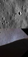
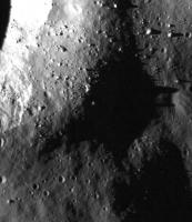
Apollo 17 ascent and LRO comparision:
-------------------- |
|
|
|
|
|
|
Jul 17 2009, 05:22 PM
Post
#23
|
||
|
Junior Member Group: Members Posts: 41 Joined: 12-April 06 Member No.: 738 |
Yes Phil, I concur with the Geophone rock shadow!
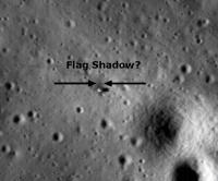
I know this is a wild guess for the Apollo 14 image, but could this be the...
Attached thumbnail(s)
|
|
|
|
|
|
|
Jul 17 2009, 05:38 PM
Post
#24
|
||
|
Lord Of The Uranian Rings Group: Members Posts: 798 Joined: 18-July 05 From: Plymouth, UK Member No.: 437 |
Apollo 11 ascent and LRO comparison:
-------------------- |
|
|
|
|
|
|
Jul 17 2009, 05:43 PM
Post
#25
|
|
|
Member Group: Members Posts: 813 Joined: 29-December 05 From: NE Oh, USA Member No.: 627 |
QUOTE (Tubo @ Jul 17 2009, 12:08 PM) So far it seems that the Apollo 14 Landing site shot has got the greatest resolution, aren't the MET tracks the ones visible? Luv It! Craig |
|
|
|
|
Jul 17 2009, 05:57 PM
Post
#26
|
||
|
Lord Of The Uranian Rings Group: Members Posts: 798 Joined: 18-July 05 From: Plymouth, UK Member No.: 437 |
Apollo 16 ascent footage frame / LRO comparison:
Curiously, the LRV itself isn't visible, although the shadow it casts towards the east certainly is. -------------------- |
|
|
|
|
|
|
Jul 17 2009, 05:57 PM
Post
#27
|
|
|
Member Group: Members Posts: 150 Joined: 3-June 08 From: McLean, VA Member No.: 4177 |
QUOTE (FordPrefect) I know this is a wild guess for the Apollo 14 image, but could this be the... Flag shadow?Or maybe the big S-band deployable antenna... |
|
|
|
|
Jul 17 2009, 06:05 PM
Post
#28
|
|
 Senior Member Group: Members Posts: 1465 Joined: 9-February 04 From: Columbus OH USA Member No.: 13 |
Wow. LRO has really come out of the gate hitting on all cylinders. Very evocative shots.
-------------------- |
|
|
|
|
Jul 17 2009, 06:05 PM
Post
#29
|
|
|
Newbie Group: Members Posts: 4 Joined: 24-June 09 Member No.: 4837 |
QUOTE Or maybe the big S-band deployable antenna... I would go for the antenna too, even though it wouldn't cast a so distinct shadow... Do you think the nylon of the flag would survive 40 years up there? -------------------- |
|
|
|
|
Jul 17 2009, 06:06 PM
Post
#30
|
||
|
Lord Of The Uranian Rings Group: Members Posts: 798 Joined: 18-July 05 From: Plymouth, UK Member No.: 437 |
Apollo 14 ascent / LRO comparison - the black arrow in both images is pointing toward Turtle Rock:
-------------------- |
|
|
|
|
|
|
Jul 17 2009, 06:26 PM
Post
#31
|
||
|
Lord Of The Uranian Rings Group: Members Posts: 798 Joined: 18-July 05 From: Plymouth, UK Member No.: 437 |
Apollo 11 descent footage frame compared to LRO view. Both have been oriented so that west is 'up':
-------------------- |
|
|
|
|
|
|
Jul 17 2009, 06:31 PM
Post
#32
|
||
|
Lord Of The Uranian Rings Group: Members Posts: 798 Joined: 18-July 05 From: Plymouth, UK Member No.: 437 |
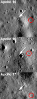
Probable locations of LRVs (definite in the case of Apollo 16):
-------------------- |
|
|
|
|
|
|
Jul 17 2009, 07:05 PM
Post
#33
|
|
|
Member Group: Members Posts: 150 Joined: 3-June 08 From: McLean, VA Member No.: 4177 |
The main NASA LRO site has larger views centered around the landing sites:
http://www.nasa.gov/mission_pages/LRO/mult...pollosites.html This one, from '11: http://www.nasa.gov/images/content/369440m...pollo11_lrg.jpg ...really shows West crater and those big boulders Armstrong decided against landing next to. |
|
|
|
|
Jul 17 2009, 07:06 PM
Post
#34
|
|
|
Junior Member Group: Members Posts: 41 Joined: 12-April 06 Member No.: 738 |
QUOTE (Paul Fjeld @ Jul 17 2009, 07:57 PM) Or maybe the big S-band deployable antenna... QUOTE (Tubo @ Jul 17 2009, 08:05 PM) I would go for the antenna too, even though it wouldn't cast a so distinct shadow... Do you think the nylon of the flag would survive 40 years up there? Maybe. One should remember though that the S-Band antenna blew over during the hot-fire jets check shortly prior lift-off. MET shadow? |
|
|
|
|
Jul 17 2009, 07:09 PM
Post
#35
|
|
|
Member Group: Members Posts: 150 Joined: 3-June 08 From: McLean, VA Member No.: 4177 |
Even on its side, its bigger than the MET...
QUOTE (Ian R) Probable locations of LRVs (definite in the case of Apollo 16): I think you nailed 'em. |
|
|
|
|
Jul 17 2009, 07:16 PM
Post
#36
|
|
|
Newbie Group: Members Posts: 4 Joined: 24-June 09 Member No.: 4837 |
QUOTE (FordPrefect @ Jul 17 2009, 08:06 PM) Maybe. One should remember though that the S-Band antenna blew over during the hot-fire jets check shortly prior lift-off. MET shadow? Yes, let's wait for higher res images. Guys, I'm so excited with these yet! -------------------- |
|
|
|
|
Jul 17 2009, 07:46 PM
Post
#37
|
|
|
Member Group: Members Posts: 150 Joined: 3-June 08 From: McLean, VA Member No.: 4177 |
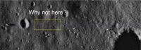
Anybody else having trouble finding the landing sites from the Zoomify big pictures on the LROC site? Man! I keep scrolling, hunting, but I can't find anything yet. Maybe I'm too excited. I'm using the larger scale maps from Lunar Orbiter for context, putting the image in Lat/Long focus around the published location for the site, and still no use... I thought I had a good eye! If anybody can give me a rough location on the big strip for Apollo 14, I would be much obliged.
|
|
|
|
|
Jul 17 2009, 07:51 PM
Post
#38
|
|
|
Solar System Cartographer Group: Members Posts: 10164 Joined: 5-April 05 From: Canada Member No.: 227 |
Look on the extreme right side - Triplet crater only just makes it onto the image.
Phil -------------------- ... because the Solar System ain't gonna map itself.
Also to be found posting similar content on https://mastodon.social/@PhilStooke Maps for download (free PD: https://upload.wikimedia.org/wikipedia/comm...Cartography.pdf NOTE: everything created by me which I post on UMSF is considered to be in the public domain (NOT CC, public domain) |
|
|
|
|
Jul 17 2009, 08:18 PM
Post
#39
|
|
|
Member Group: Members Posts: 150 Joined: 3-June 08 From: McLean, VA Member No.: 4177 |
Thanks! Maybe an eighth of the image height above the center.
I was scanning for Cone crater and Triplet but, of course, no Cone crater. We'll have to look for the later shots to see exactly where Al and Ed ended up before turning back down the mountain without that view... |
|
|
|
|
Jul 17 2009, 08:19 PM
Post
#40
|
|
|
Senior Member Group: Members Posts: 1465 Joined: 9-February 04 From: Columbus OH USA Member No.: 13 |
QUOTE (Ian R @ Jul 17 2009, 02:31 PM) Probable locations of LRVs (definite in the case of Apollo 16): I see a lot of parking tickets under the wiper. -------------------- |
|
|
|
|
Jul 17 2009, 08:36 PM
Post
#41
|
|
|
Member Group: Members Posts: 813 Joined: 29-December 05 From: NE Oh, USA Member No.: 627 |
QUOTE (Paul Fjeld @ Jul 17 2009, 03:18 PM) Thanks! Maybe an eighth of the image height above the center. I was scanning for Cone crater and Triplet but, of course, no Cone crater. We'll have to look for the later shots to see exactly where Al and Ed ended up before turning back down the mountain without that view... Yeah... I finally found it. Not easy. What clued me in was a comment from the teleconference that Cone Crater was out of view on the image track to the east. So I scrolled up the right side of the image until I saw Triplet. Interesting that we can see the tracks from EVA 1 but I see nothing to the east for EVA 2. I assume the lighting might have something to do with it, or it is because EVA 1 was more scuffed up and traveled? Can't wait for the highr res including the Cone crater traverse. Craig |
|
|
|
|
Jul 17 2009, 08:39 PM
Post
#42
|
|
|
Member Group: Members Posts: 813 Joined: 29-December 05 From: NE Oh, USA Member No.: 627 |
Ok... I just submitted post #41 and now I think I do see a very faint track to the east on the Apollo 14 image.
Craig |
|
|
|
|
Jul 17 2009, 09:59 PM
Post
#43
|
|
 Senior Member Group: Members Posts: 2492 Joined: 15-January 05 From: center Italy Member No.: 150 |
Sirs, I am speechless, first due to these LRO images (and perfect timing of release) and second for the great identification effort you're doing...
Is like to see man on the moon for the second time! 
-------------------- I always think before posting! - Marco -
|
|
|
|
|
Jul 17 2009, 11:21 PM
Post
#44
|
|
 Senior Member Group: Members Posts: 3419 Joined: 9-February 04 From: Minneapolis, MN, USA Member No.: 15 |
Seems strange to see the sites with sun from the west, though. Never saw these sites in afternoon sun before!
I am *really* looking forward to the pics that will come down from the science orbit! -the other Doug -------------------- The trouble ain't that there is too many fools, but that the lightning ain't distributed right. -Mark Twain
|
|
|
|
|
Jul 17 2009, 11:51 PM
Post
#45
|
||
|
Member Group: Members Posts: 808 Joined: 10-October 06 From: Maynard Mass USA Member No.: 1241 |
Here is an attempt to enhance the immediate Apollo 11 site from LROC
The striping of the camera system is apparent; just pushing noise around at this altitude and with no calibration
Cheers -------------------- CLA CLL
|
|
|
|
|
|
|
Jul 18 2009, 12:26 AM
Post
#46
|
||
|
Senior Member Group: Members Posts: 1074 Joined: 21-September 07 From: Québec, Canada Member No.: 3908 |
Here's an interesting view: a crop of the Apollo 16 image showing North Ray crater and House Rock (in the center of the image). For me, one of the highlights of the whole Apollo expeditions.
Attached thumbnail(s)
|
|
|
|
|
|
|
Jul 18 2009, 12:47 AM
Post
#47
|
|
|
Senior Member Group: Members Posts: 1465 Joined: 9-February 04 From: Columbus OH USA Member No.: 13 |
Maybe they'll wait until they get even closer to look in earnest, but one of the science goals of reimaging the sites also photographed at close range by the Apollo cameras is to look for evidence of fresh impacts, to get a handle on how often they occur & quantify the risk to a moon base.
-------------------- |
|
|
|
|
Jul 18 2009, 12:52 AM
Post
#48
|
|
 Senior Member Group: Admin Posts: 4763 Joined: 15-March 05 From: Glendale, AZ Member No.: 197 |
QUOTE (jmknapp @ Jul 17 2009, 04:47 PM) one of the science goals of reimaging the sites also photographed at close range by the Apollo cameras is to look for evidence of fresh impacts, Imagine the reaction after all this talk about historical preservation, if we finally got a look at the A11 site and it was occupied by a large fresh new crater and nothing else. Fortunately that didn't happen (yet). -------------------- If Occam had heard my theory, things would be very different now.
|
|
|
|
|
Jul 18 2009, 12:58 AM
Post
#49
|
|
|
Merciless Robot Group: Admin Posts: 8784 Joined: 8-December 05 From: Los Angeles Member No.: 602 |
One of my nightmares, too.
Fortunately, I'm optimistic that the meter-thick transparent artificial diamond dome over the entire site will be completed on schedule by the fourth quarter of fiscal year 2329... EDIT: It is my sad duty to report the passing today of legendary newsman Walter Cronkite, who was iconic to US viewers as the face of TV coverage for the Apollo 11 flight. How bitterly ironic. 
-------------------- A few will take this knowledge and use this power of a dream realized as a force for change, an impetus for further discovery to make less ancient dreams real.
|
|
|
|
|
Jul 18 2009, 01:02 AM
Post
#50
|
||
|
Member Group: Members Posts: 104 Joined: 1-June 08 Member No.: 4172 |
Another attempt on the A11 image, using GIMP's Destripe filter and two runs of the NEDI upscaling algorithm:
|
|
|
|
|
|
|
Jul 18 2009, 01:07 AM
Post
#51
|
|
|
Senior Member Group: Members Posts: 1465 Joined: 9-February 04 From: Columbus OH USA Member No.: 13 |
QUOTE (nprev @ Jul 17 2009, 08:58 PM) EDIT: It is also my sad duty to report the passing today of legendary newsman Walter Cronkite, who was iconic to US viewers as the face of TV coverage for the Apollo 11 flight. How bitterly ironic. Well, I can say I heard it first on UMSF. <taking off glasses> -------------------- |
|
|
|
|
Jul 18 2009, 01:08 AM
Post
#52
|
||
|
Member Group: Members Posts: 150 Joined: 3-June 08 From: McLean, VA Member No.: 4177 |
One of LRO's goals is to characterize possible future unmanned and manned landing sites - what constitutes a hazard and where are you pretty much guaranteed to drop something in comfortably. Looking at the Apollo 11 approach, I wonder if such a characterization would not include the area before Baby West. It's clear that Armstrong looked there and changed his mind to overfly the last crater (not a small risk in itself), but I can't see anything at this rez which should hurt a landing. We need the higher resolution from the lower orbits of course, but I wonder what this will do to landing zone criteria or if it will just start silly debates and Monday morning (40 years later) quarterbacking, which I am endeavoring not to do here.
Attached thumbnail(s)
|
|
|
|
|
|
|
Jul 18 2009, 01:23 AM
Post
#53
|
|
|
Member Group: Members Posts: 150 Joined: 3-June 08 From: McLean, VA Member No.: 4177 |
QUOTE (charborob) Here's an interesting view: a crop of the Apollo 16 image showing North Ray crater and House Rock ... That is stupendous! I think that when all of the sites are shot and processed to their best, it will be a very great pleasure to put on a DVD and watch the EVAs with these images on hand. Perhaps someone will generate a really fine quality 3d environment from them and we can even, one day, walk along with those explorers. |
|
|
|
|
Jul 18 2009, 01:31 AM
Post
#54
|
|
|
Senior Member Group: Members Posts: 3419 Joined: 9-February 04 From: Minneapolis, MN, USA Member No.: 15 |
Paul, I think I see a higher population of boulders in the relatively clear area you've outlined than in the area where the LM is located. And seeing as there are fewer boulders visible on the rim and ramparts of West in the LROC image than can be seen on the descent film, I'd imagine that the actual boulder population short of Little West was the determinant in Neil's choice to continue on downrange.
IIRC, you can see the boulder population throughout that area short of Little West in the descent film, and it seems to me that it was the natural outlying fan of ejecta from West. I can certainly understand if Neil, seeing the boulder field thin out, would want to overfly the ejecta field entirely. -the other Doug -------------------- The trouble ain't that there is too many fools, but that the lightning ain't distributed right. -Mark Twain
|
|
|
|
|
Jul 18 2009, 01:39 AM
Post
#55
|
|
|
Member Group: Members Posts: 150 Joined: 3-June 08 From: McLean, VA Member No.: 4177 |
Very good point. So it will be interesting when the highest resolution images come down of that area before Little West to see if those boulders are visible. If not, then how do you characterize a safe landing site from these images?
I've seen a paper somewhere (wish I could remember) describing a system with LIDAR images that are scanned and analyzed automatically for safe zones - perhaps you put in some smarts that adds a buffer to ejecta blankets (call the routine ArmstrongSmarts)? |
|
|
|
|
Jul 18 2009, 01:54 AM
Post
#56
|
|
|
Member Group: Members Posts: 808 Joined: 10-October 06 From: Maynard Mass USA Member No.: 1241 |
Jekbradury...awesome de-stripe-ing!!
-------------------- CLA CLL
|
|
|
|
|
Jul 18 2009, 01:55 AM
Post
#57
|
|
|
Senior Member Group: Members Posts: 1583 Joined: 14-October 05 From: Vermont Member No.: 530 |
QUOTE (nprev @ Jul 17 2009, 12:55 PM) It'll get better, but for now I'm really happy just to see these old friends from my youth again. On this day, of all days, Walter Cronkite dies... crazy! |
|
|
|
|
Jul 18 2009, 02:03 AM
Post
#58
|
|
 Junior Member Group: Members Posts: 55 Joined: 1-May 06 From: Cincinnati, Ohio Member No.: 758 |
Armstrong's said something like that the auto-targeting was taking them into a boulder strewn crater. And a pilot's adage "When in doubt, land long." He did land long, and that worked just fine, thank you very much. If Eagle had been a robot, she would have gone down in that crater, likely to no good end...
Also rememebr that at that point in their descent (you'd have to overlay the ground track under the altitude and velocity profile) they were not in a hover and still had some horizontal velocity to shed. So old Neil put the descent engine thrust more vertical and flew Eagle to a better spot. I guess he was right! :-) These are fantastic photos and I am enjoying this side discussion very much. Rob |
|
|
|
|
Jul 18 2009, 02:09 AM
Post
#59
|
|
|
Member Group: Members Posts: 150 Joined: 3-June 08 From: McLean, VA Member No.: 4177 |
No question he was right! My interest is in how LRO data will characterize an area we know a person would not consider good - are half-meter boulders okay? Armstrong thought not, even though he had already gone past the serious danger of the big West's boulder field and had shed most of his forward velocity by the time he arrived near Little West.
|
|
|
|
|
Jul 18 2009, 02:11 AM
Post
#60
|
|||
|
Junior Member Group: Members Posts: 55 Joined: 1-May 06 From: Cincinnati, Ohio Member No.: 758 |
I found these scans on the Apollo Surface Journal...
Attached thumbnail(s)
|
||
|
|
|
||
|
Jul 18 2009, 02:14 AM
Post
#61
|
||
|
Junior Member Group: Members Posts: 55 Joined: 1-May 06 From: Cincinnati, Ohio Member No.: 758 |
This one is a vertical view from the Eagle during rendezvous. Note the CM below and the "estimated" landing point.
Attached thumbnail(s)
|
|
|
|
|
|
|
Jul 18 2009, 08:51 AM
Post
#62
|
|
|
Member Group: Members Posts: 233 Joined: 21-April 05 Member No.: 328 |
Belleraphon1, even before reading your posts re the Apollo 14 landing site, I was pretty sure I saw tracks wandering off to the east/north east. And this is exactly in the direction of Cone Crater! BTW, I am not as up on my Apollo history as I should be, but the edge of Cone Crater is about 1 km from the landing site. That's pretty nervy, walking that distance from the [relative] security of the LEM!
robspace54, i's a very useful diagram you've dug up, of the various camera angles etc. around the Apollo 11 landing site. |
|
|
|
|
Jul 18 2009, 12:41 PM
Post
#63
|
|
 Member Group: Members Posts: 753 Joined: 23-October 04 From: Greensboro, NC USA Member No.: 103 |
QUOTE (jekbradbury @ Jul 17 2009, 08:02 PM) Another attempt on the A11 image, using GIMP's Destripe filter and two runs of the NEDI upscaling algorithm: Does anyone else see a black dot in the approximate location the flag was? Can't tell if it's a small crater, a processing artifact, or if something is actually casting a shadow. I know that the LMP said the flag blew over - I just think this is an interesting coincidence. -------------------- Jonathan Ward
Manning the LCC at http://www.apollolaunchcontrol.com |
|
|
|
|
Jul 18 2009, 01:26 PM
Post
#64
|
||
|
Junior Member Group: Members Posts: 55 Joined: 1-May 06 From: Cincinnati, Ohio Member No.: 758 |
QUOTE (glennwsmith @ Jul 18 2009, 03:51 AM) Belleraphon1, even before reading your posts re the Apollo 14 landing site, I was pretty sure I saw tracks wandering off to the east/north east. And this is exactly in the direction of Cone Crater! BTW, I am not as up on my Apollo history as I should be, but the edge of Cone Crater is about 1 km from the landing site. That's pretty nervy, walking that distance from the [relative] security of the LEM! robspace54, i's a very useful diagram you've dug up, of the various camera angles etc. around the Apollo 11 landing site. As for nervy, think about where they were and what they were doing! I can also see that black dot, but based on the "map" it looks too close to the descent stage. BUT... if you look almost due south about 3 "LMs" away the EASEP seismometer is visible. It is a rectangular looking blob, long axis north-south, with a shadow to the east. I also "see" the LRRR just meters north of the seismometer. Rob
Attached thumbnail(s)
|
|
|
|
|
|
|
Jul 18 2009, 01:52 PM
Post
#65
|
||
|
Junior Member Group: Members Posts: 55 Joined: 1-May 06 From: Cincinnati, Ohio Member No.: 758 |
ADMIN EDIT
Looks like Pierre Mion got it right! Rob
Attached thumbnail(s)
|
|
|
|
|
|
|
Jul 18 2009, 04:30 PM
Post
#66
|
||
|
Member Group: Members Posts: 104 Joined: 1-June 08 Member No.: 4172 |
Here's the Apollo 14 landing site, with the same processing:
|
|
|
|
|
|
|
Jul 18 2009, 04:40 PM
Post
#67
|
|
|
Member Group: Members Posts: 753 Joined: 23-October 04 From: Greensboro, NC USA Member No.: 103 |
This processing technique "doubles" some of the small craters, does it? I assume it's due to the compression? Or is it just my imagination too? Both this and the A11 site look like they have rabbit or deer prints across them.
-------------------- Jonathan Ward
Manning the LCC at http://www.apollolaunchcontrol.com |
|
|
|
|
Jul 18 2009, 04:41 PM
Post
#68
|
||
|
Solar System Cartographer Group: Members Posts: 10164 Joined: 5-April 05 From: Canada Member No.: 227 |
A bit more on Apollo 14:
The tracks from Station A to Station B are very clear, even the little loop they did at Station B around a little crater. Tracks from LM to A are visible too. I can't see the return tracks from Station G around North Triplet at all. (no crater doubling here - it's all in how you deal with the stripes!) Phil -------------------- ... because the Solar System ain't gonna map itself.
Also to be found posting similar content on https://mastodon.social/@PhilStooke Maps for download (free PD: https://upload.wikimedia.org/wikipedia/comm...Cartography.pdf NOTE: everything created by me which I post on UMSF is considered to be in the public domain (NOT CC, public domain) |
|
|
|
|
|
|
Jul 18 2009, 04:52 PM
Post
#69
|
|
|
Member Group: Members Posts: 813 Joined: 29-December 05 From: NE Oh, USA Member No.: 627 |
QUOTE (robspace54 @ Jul 18 2009, 08:26 AM) As for nervy, think about where they were and what they were doing! I can also see that black dot, but based on the "map" it looks too close to the descent stage. BUT... if you look almost due south about 3 "LMs" away the EASEP seismometer is visible. It is a rectangular looking blob, long axis north-south, with a shadow to the east. I also "see" the LRRR just meters north of the seismometer. Rob glennwsmith and robspace54.... yeah that is why Apollo 14 is one of my favorite missions. They were really extending their EVA reach, given no Rover. Any yeah, I am pretty confidant now those are the tracks going NE. They follow the mission plot pretty well. Cannot wait to see Cone Crater. Listen to the transcipts here http://history.nasa.gov/alsj/a14/a14.html |
|
|
|
|
Jul 18 2009, 05:25 PM
Post
#70
|
|
|
Member Group: Members Posts: 150 Joined: 3-June 08 From: McLean, VA Member No.: 4177 |
QUOTE (Phil Stooke) The tracks from Station A to Station B are very clear, even the little loop they did at Station B around a little crater. Tracks from LM to A are visible too. I can't see the return tracks from Station G around North Triplet at all. Amazing processing! It almost seems dead certain that all of the site images will have clear EVA trails when LRO is done. Rob, you've convinced me about the '11 seismometer. (I've gotta get back to work!) |
|
|
|
|
Jul 18 2009, 06:04 PM
Post
#71
|
|
 Senior Member Group: Members Posts: 1281 Joined: 18-December 04 From: San Diego, CA Member No.: 124 |
Can't wait for Apollo 12 and the images of an actual unmanned spacecraft
BTW, this thread is phenomenal. I am in awe at how fast board members update the imagery with the dialog- moving at the speed of thought! -------------------- Lyford Rome
"Zis is not nuts, zis is super-nuts!" Mathematician Richard Courant on viewing an Orion test |
|
|
|
|
Jul 18 2009, 08:19 PM
Post
#72
|
||
|
Solar System Cartographer Group: Members Posts: 10164 Joined: 5-April 05 From: Canada Member No.: 227 |
This is Apollo 17 station 6, the big split boulder. If you compare it with my first view of it (page 2 of this thread), this is much better. This is from the raw TIFF file, which is much better to work with than the zoomify version. Thanks, Mark Robinson, for letting us have this so soon.
Phil
PS - there's a fantastic mountaintop south of the valley at this site with a huge cluster of boulders on it. -------------------- ... because the Solar System ain't gonna map itself.
Also to be found posting similar content on https://mastodon.social/@PhilStooke Maps for download (free PD: https://upload.wikimedia.org/wikipedia/comm...Cartography.pdf NOTE: everything created by me which I post on UMSF is considered to be in the public domain (NOT CC, public domain) |
|
|
|
|
|
|
Jul 18 2009, 09:11 PM
Post
#73
|
||
|
Solar System Cartographer Group: Members Posts: 10164 Joined: 5-April 05 From: Canada Member No.: 227 |
This is Apollo 17 station 5 on the edge of Camelot crater. It's the place where the famous images of an astronaut in a dramatic boulder field were taken. The rocks are visible along the rim, but no tracks I can make out.
Phil
-------------------- ... because the Solar System ain't gonna map itself.
Also to be found posting similar content on https://mastodon.social/@PhilStooke Maps for download (free PD: https://upload.wikimedia.org/wikipedia/comm...Cartography.pdf NOTE: everything created by me which I post on UMSF is considered to be in the public domain (NOT CC, public domain) |
|
|
|
|
|
|
Jul 18 2009, 09:48 PM
Post
#74
|
|
|
The Poet Dude Group: Moderator Posts: 5551 Joined: 15-March 04 From: Kendal, Cumbria, UK Member No.: 60 |
QUOTE (Phil Stooke @ Jul 18 2009, 10:11 PM) It's the place where the famous images of an astronaut in a dramatic boulder field were taken. This one..? http://www.lpod.org/wp-content/uploads/2007/12/Ap17-pan.jpg -------------------- |
|
|
|
|
Jul 18 2009, 09:56 PM
Post
#75
|
|
|
Solar System Cartographer Group: Members Posts: 10164 Joined: 5-April 05 From: Canada Member No.: 227 |
Yes, that one. Pretty nice, huh?
Phil -------------------- ... because the Solar System ain't gonna map itself.
Also to be found posting similar content on https://mastodon.social/@PhilStooke Maps for download (free PD: https://upload.wikimedia.org/wikipedia/comm...Cartography.pdf NOTE: everything created by me which I post on UMSF is considered to be in the public domain (NOT CC, public domain) |
|
|
|
|
Jul 18 2009, 10:35 PM
Post
#76
|
|
|
The Poet Dude Group: Moderator Posts: 5551 Joined: 15-March 04 From: Kendal, Cumbria, UK Member No.: 60 |
QUOTE (Phil Stooke @ Jul 18 2009, 10:56 PM) Yes, that one. Pretty nice, huh? One of my personal fave images, actually. Showed it in my talk last night, and it always impresses people. I think it's the contrast between the fragile-looking, puffy spacesuit and the OMG They Look Sharp! pointy rocks in the foreground... ;-) -------------------- |
|
|
|
|
Jul 19 2009, 11:01 AM
Post
#77
|
|
 Member Group: Members Posts: 107 Joined: 29-January 09 Member No.: 4589 |
QUOTE (belleraphon1 @ Jul 18 2009, 05:52 PM) glennwsmith and robspace54.... yeah that is why Apollo 14 is one of my favorite missions. They were really extending their EVA reach, given no Rover. Any yeah, I am pretty confidant now those are the tracks going NE. They follow the mission plot pretty well. Cannot wait to see Cone Crater. Listen to the transcipts here http://history.nasa.gov/alsj/a14/a14.html New Scientist has a nice gallery feature ("What if the Eagle had landed on Earth") showing the area covered during the respective moonlandings superimposed on a map of central London. The Apollo 14 map is here -------------------- Protein structures and Mars fun - http://www.flickr.com/photos/nick960/
|
|
|
|
|
Jul 19 2009, 11:49 AM
Post
#78
|
|
|
Senior Member Group: Members Posts: 2920 Joined: 14-February 06 From: Very close to the Pyrénées Mountains (France) Member No.: 682 |
I like it. Anyway, what would be nice will be to put the LM at Victoria near Duck's bay entrance and do the same for the 6 landings.
This will put it more in a UMSF perspective.
-------------------- |
|
|
|
|
Jul 19 2009, 12:07 PM
Post
#79
|
|
|
Junior Member Group: Members Posts: 53 Joined: 15-July 09 Member No.: 4867 |
Very nice job guys, the images are really great !
|
|
|
|
|
Jul 19 2009, 12:18 PM
Post
#80
|
|
|
The Poet Dude Group: Moderator Posts: 5551 Joined: 15-March 04 From: Kendal, Cumbria, UK Member No.: 60 |
Stunning image processing work guys, I'm in awe of your skills, as usual...!
Thanks to everyone who gave me permission to use their work in my CS blog post about these fantastic images from LRO... Apollo Revisited. -------------------- |
|
|
|
| Guest_Zvezdichko_* |
Jul 19 2009, 02:07 PM
Post
#81
|
|
Guests |
|
|
|
|
|
Jul 19 2009, 06:17 PM
Post
#82
|
|
|
The Poet Dude Group: Moderator Posts: 5551 Joined: 15-March 04 From: Kendal, Cumbria, UK Member No.: 60 |
QUOTE (Zvezdichko @ Jul 19 2009, 03:07 PM) Broken link Aaggghhh! Apologies anyone who tried to access that; glitch meant that Wordpress didn't accept the change from Private to Public status of the post. Working now at http://cumbriansky.wordpress.com/2009/07/18/apollo-revisited -------------------- |
|
|
|
|
Jul 19 2009, 06:26 PM
Post
#83
|
|
|
Merciless Robot Group: Admin Posts: 8784 Joined: 8-December 05 From: Los Angeles Member No.: 602 |
Working fine now, Stu. Excellent post!
-------------------- A few will take this knowledge and use this power of a dream realized as a force for change, an impetus for further discovery to make less ancient dreams real.
|
|
|
|
|
Jul 19 2009, 06:36 PM
Post
#84
|
|
|
Senior Member Group: Members Posts: 3419 Joined: 9-February 04 From: Minneapolis, MN, USA Member No.: 15 |
I know it has a lot to do with a variety of factors, including sun angle and such, but I'm impressed that the MET tracks in the Fra Mauro images are more visible than LRV tracks are in the Hadley, Descartes and Taurus-Littrow images.
Perhaps the tracks at Fra Mauro are more visible because they are accompanied by a track of footprints (which are more visible in the J-mission site images than are areas where you would only find LRV tracks). But I'm a little surprised that LRV tracks, when unaccompanied by footprint tracks, are far less visible than I would have expected. -the other Doug -------------------- The trouble ain't that there is too many fools, but that the lightning ain't distributed right. -Mark Twain
|
|
|
|
|
Jul 19 2009, 06:41 PM
Post
#85
|
|
|
Senior Member Group: Members Posts: 3419 Joined: 9-February 04 From: Minneapolis, MN, USA Member No.: 15 |
BTW -- my roommate seemed a little disappointed with the Fra Mauro image.
"Where's the golf ball?" is what he said to me. -the other Doug -------------------- The trouble ain't that there is too many fools, but that the lightning ain't distributed right. -Mark Twain
|
|
|
|
|
Jul 19 2009, 08:21 PM
Post
#86
|
|
|
Member Group: Members Posts: 156 Joined: 22-May 09 From: Ireland Member No.: 4792 |
|
|
|
|
|
Jul 19 2009, 10:01 PM
Post
#87
|
|
 Member Group: Members Posts: 550 Joined: 1-May 06 From: Scotland (Ecosse, Escocia) Member No.: 759 |
At the beginning of this thread there is some discussion about the visiblity of the flags. Doubtless this will be re-visited when higher-res images of the sites become available. If still upright, we'd perhaps be looking for a shadow, or if fallen over (as at the Apollo 11 site), we'd expect to see a bright rectangular object.
HOWEVER, in the opinion of the guy whose company made the flags out of nylon and sold them to NASA for $5.50 each.... they will have gone brittle, disintegrated and turned to "ashes". I suppose here might be a stain left, but maybe not even that. Air & Space mag Finding Apollo |
|
|
|
|
Jul 19 2009, 10:34 PM
Post
#88
|
|
|
Senior Member Group: Members Posts: 2517 Joined: 13-September 05 Member No.: 497 |
QUOTE (kenny @ Jul 19 2009, 03:01 PM) HOWEVER, in the opinion of the guy whose company made the flags out of nylon...[/url] With all due respect, it's not like this guy is a materials scientist or anything -- I doubt he has much idea of what vacuum exposure and temperature extremes will do to nylon (and I don't either, but I suspect the lunar environment is more benign than one might think -- most degradation of nylon on LDEF was from atomic oxygen, which is totally absent on the Moon.) We use nylon tie-wraps on instrument cables routinely. Fading of the flag from UV exposure seems almost inevitable, though. -------------------- Disclaimer: This post is based on public information only. Any opinions are my own.
|
|
|
|
|
Jul 20 2009, 12:02 AM
Post
#89
|
||
|
The Poet Dude Group: Moderator Posts: 5551 Joined: 15-March 04 From: Kendal, Cumbria, UK Member No.: 60 |
Sorry, but you can forget looking for the flag...
-------------------- |
|
|
|
|
|
|
Jul 20 2009, 12:13 AM
Post
#90
|
|
|
Merciless Robot Group: Admin Posts: 8784 Joined: 8-December 05 From: Los Angeles Member No.: 602 |
<shaking fist> @$%# LUNAR RODENT!!!
-------------------- A few will take this knowledge and use this power of a dream realized as a force for change, an impetus for further discovery to make less ancient dreams real.
|
|
|
|
|
Jul 20 2009, 12:59 AM
Post
#91
|
|
|
Senior Member Group: Members Posts: 3419 Joined: 9-February 04 From: Minneapolis, MN, USA Member No.: 15 |
Which reminds me -- I would have to imagine that the LROC images will be good enough that we'll be able to make out the enormous mousetrap built by the lost Apollo crew at Sinus Medii, right?
 -the other Rod Serling -------------------- The trouble ain't that there is too many fools, but that the lightning ain't distributed right. -Mark Twain
|
|
|
|
|
Jul 20 2009, 10:16 AM
Post
#92
|
|
|
The Poet Dude Group: Moderator Posts: 5551 Joined: 15-March 04 From: Kendal, Cumbria, UK Member No.: 60 |
Some very interesting stuff on this forum's LRO thread. Can't read French but the analysis of the LRO pics is fascinating...
http://www.forum-conquete-spatiale.fr/la-l...r-lro-t8404.htm -------------------- |
|
|
|
|
Jul 20 2009, 12:04 PM
Post
#93
|
|
|
Senior Member Group: Members Posts: 1465 Joined: 9-February 04 From: Columbus OH USA Member No.: 13 |
QUOTE (Stu @ Jul 20 2009, 06:16 AM) Some very interesting stuff on this forum's LRO thread. Can't read French but the analysis of the LRO pics is fascinating... http://www.forum-conquete-spatiale.fr/la-l...r-lro-t8404.htm Babelfish does a pretty good translation job though: Le Forum de la Conquête Spatiale -------------------- |
|
|
|
|
Jul 20 2009, 12:15 PM
Post
#94
|
|
|
Senior Member Group: Members Posts: 2920 Joined: 14-February 06 From: Very close to the Pyrénées Mountains (France) Member No.: 682 |
QUOTE (Stu @ Jul 20 2009, 12:16 PM) Some very interesting stuff on this forum's LRO thread. Can't read French but the analysis of the LRO pics is fascinating... This is easy French actually. Putting the mouse on the world you are looking for translation is enough. I can help with Rocher=Rock and Ombre=Shadow the rest in the pictures is evident. I agree it's fascinating...and link has been already posted here (post#79 by lightning) -------------------- |
|
|
|
|
Jul 20 2009, 12:21 PM
Post
#95
|
|
|
Senior Member Group: Members Posts: 2920 Joined: 14-February 06 From: Very close to the Pyrénées Mountains (France) Member No.: 682 |
QUOTE (jmknapp @ Jul 20 2009, 02:04 PM) Babelfish does a pretty good translation job though: OK, you're right... except Maintenant which means "NOW" and not Maintaining
-------------------- |
|
|
|
|
Jul 20 2009, 01:05 PM
Post
#96
|
|
|
Member Group: Members Posts: 150 Joined: 3-June 08 From: McLean, VA Member No.: 4177 |
Some really good analysis "a la française."
Ariane 68 complains that his sister (he's not so sure now she really is his sister), about the LRO pics and the landings, is certain "c'est du pipo" (as he bangs his head against a brick wall). I don't know what pipo means, but I think the Hoaxers are certainly "du pipo." And how come we don't have a head-banging-a-brick-wall emoticon? |
|
|
|
|
Jul 20 2009, 01:32 PM
Post
#97
|
|
|
The Poet Dude Group: Moderator Posts: 5551 Joined: 15-March 04 From: Kendal, Cumbria, UK Member No.: 60 |
QUOTE (Paul Fjeld @ Jul 20 2009, 02:05 PM) And how come we don't have a head-banging-a-brick-wall emoticon? Because it would get used so much here that there's a very real possibility we might break the internet. -------------------- |
|
|
|
|
Jul 20 2009, 05:35 PM
Post
#98
|
|
|
Senior Member Group: Members Posts: 1465 Joined: 9-February 04 From: Columbus OH USA Member No.: 13 |
QUOTE (Paul Fjeld @ Jul 20 2009, 09:05 AM) And how come we don't have a head-banging-a-brick-wall emoticon? C'est une petite étape pour un homme, un saut géant pour l'humanité. 
-------------------- |
|
|
|
|
Jul 20 2009, 05:48 PM
Post
#99
|
|
|
Solar System Cartographer Group: Members Posts: 10164 Joined: 5-April 05 From: Canada Member No.: 227 |
Thanks! You've done your good deed for the day...
Phil -------------------- ... because the Solar System ain't gonna map itself.
Also to be found posting similar content on https://mastodon.social/@PhilStooke Maps for download (free PD: https://upload.wikimedia.org/wikipedia/comm...Cartography.pdf NOTE: everything created by me which I post on UMSF is considered to be in the public domain (NOT CC, public domain) |
|
|
|
|
Jul 20 2009, 05:53 PM
Post
#100
|
|
 Member Group: Members Posts: 259 Joined: 23-January 05 From: Seattle, WA Member No.: 156 |
QUOTE (dvandorn @ Jul 19 2009, 07:36 PM) I know it has a lot to do with a variety of factors, including sun angle and such, but I'm impressed that the MET tracks in the Fra Mauro images are more visible than LRV tracks are in the Hadley, Descartes and Taurus-Littrow images. Perhaps the tracks at Fra Mauro are more visible because they are accompanied by a track of footprints (which are more visible in the J-mission site images than are areas where you would only find LRV tracks). But I'm a little surprised that LRV tracks, when unaccompanied by footprint tracks, are far less visible than I would have expected. -the other Doug I wonder if the LRV obscures its own tracks as it goes, by scattering a layer of regolith over the freshly laid tracks. Presumably this would be less of a factor with footprints, MET tracks, Lunokhod tracks, and MER tracks, because of a slower rate of travel. |
|
|
|
|

|
Lo-Fi Version | Time is now: 22nd May 2024 - 11:00 AM |
|
RULES AND GUIDELINES Please read the Forum Rules and Guidelines before posting. IMAGE COPYRIGHT |
OPINIONS AND MODERATION Opinions expressed on UnmannedSpaceflight.com are those of the individual posters and do not necessarily reflect the opinions of UnmannedSpaceflight.com or The Planetary Society. The all-volunteer UnmannedSpaceflight.com moderation team is wholly independent of The Planetary Society. The Planetary Society has no influence over decisions made by the UnmannedSpaceflight.com moderators. |
SUPPORT THE FORUM Unmannedspaceflight.com is funded by the Planetary Society. Please consider supporting our work and many other projects by donating to the Society or becoming a member. |
|