MESSENGER orbital mission PDS data |

  |
MESSENGER orbital mission PDS data |
 Sep 20 2011, 05:05 PM Sep 20 2011, 05:05 PM
Post
#16
|
|
 Member  Group: Members Posts: 214 Joined: 30-December 05 Member No.: 628 |
Is it safe to assume that the dark "bullseye" crater marks the exact position of pole?
I've heard it called the coldest place in the solar system, but I don't know if that is still operative. It's hard to believe that such a dense metallic body as Mercury is such a poor conductor of heat, both from the interior and from the sun-exposed surfaces. |
 |
 
|
|
Sep 20 2011, 05:20 PM
Post
#17
|
|
|
Solar System Cartographer Group: Members Posts: 10228 Joined: 5-April 05 From: Canada Member No.: 227 |
Yes, it's the polar crater called Chao Meng-Fu. The amount of heat available to conduct from the interior would be very small. And of course the core may be large and metallic but the surface is rocky, not metallic. The dusty regolith would be a good insulator, not conducting heat sideways from sunlit areas. And any heat that did get in there is soon radiated away into space. Still, this might not be colder than the coldest lunar shadows, which are now referred to in the same way.
http://planetarynames.wr.usgs.gov/images/H-15.pdf Link to a PDF file of names of craters in this area, 1.5 MB. Phil -------------------- ... because the Solar System ain't gonna map itself.
Also to be found posting similar content on https://mastodon.social/@PhilStooke Maps for download (free PDF: https://upload.wikimedia.org/wikipedia/comm...Cartography.pdf NOTE: everything created by me which I post on UMSF is considered to be in the public domain (NOT CC, public domain) |
|
|
|
|
Sep 25 2011, 07:55 PM
Post
#18
|
|||
|
Solar System Cartographer Group: Members Posts: 10228 Joined: 5-April 05 From: Canada Member No.: 227 |
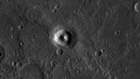
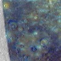
There's lots to see by browsing around that global map, even at this stage. Here is an unusual crater:
It looks like an impact crater with a very large central peak. But it falls at the edge of pre-orbital color coverage:
(top left) - where it coincides with an orange patch. In the false color composites made by the MESSENGER team this signifies pyroclastics. And the odd crater has no raised rim. Is it really just an extra-large explosive volcanism pit? Or one that completely surrounds the central peak of a regular crater? (some pits do curve part way around the floors of other craters). The big basin in the color image is Beethoven. Phil -------------------- ... because the Solar System ain't gonna map itself.
Also to be found posting similar content on https://mastodon.social/@PhilStooke Maps for download (free PDF: https://upload.wikimedia.org/wikipedia/comm...Cartography.pdf NOTE: everything created by me which I post on UMSF is considered to be in the public domain (NOT CC, public domain) |
||
|
|
|
||
|
Sep 29 2011, 03:45 PM
Post
#19
|
|
 Administrator Group: Admin Posts: 5172 Joined: 4-August 05 From: Pasadena, CA, USA, Earth Member No.: 454 |
I just realized I hadn't started this thread in the proper subforum, so I moved it into the MESSENGER subforum.
-------------------- My website - My Patreon - @elakdawalla on Twitter - Please support unmannedspaceflight.com by donating here.
|
|
|
|
|
Sep 29 2011, 08:45 PM
Post
#20
|
|
 Director of Galilean Photography Group: Members Posts: 896 Joined: 15-July 04 From: Austin, TX Member No.: 93 |
Phil,
That to me looks like a Mt. St. Helens-style volcano that blew its top and is regenerating itself. Can't see why that couldn't happen elsewhere in the Solar System. -------------------- Space Enthusiast Richard Hendricks
-- "The engineers, as usual, made a tremendous fuss. Again as usual, they did the job in half the time they had dismissed as being absolutely impossible." --Rescue Party, Arthur C Clarke Mother Nature is the final inspector of all quality. |
|
|
|
|
Oct 8 2011, 05:57 PM
Post
#21
|
|
 Senior Member Group: Members Posts: 1669 Joined: 5-March 05 From: Boulder, CO Member No.: 184 |
QUOTE (Phil Stooke @ Sep 19 2011, 09:38 PM)  Recent south pole images have filled in the whole polar gap in earlier maps. Here's a new mosaic. Hi Steve! You might like this... Phil [attachment=25567:southern...led_post.jpg] Greetings Phil (and tanjent), Yes, very nice to see this south polar mosaic. It is being included in a series of ongoing revisions to my map as can be seen here: http://laps.noaa.gov/albers/sos/sos.html#MERCURY I am showing the South Pole to be just inside the rim of Chao Meng-Fu. Steve -------------------- Steve [ my home page and planetary maps page ]
|
|
|
|
|
Oct 25 2012, 09:08 PM
Post
#22
|
|
|
Newbie Group: Members Posts: 9 Joined: 17-March 10 Member No.: 5271 |
Have they released any good topographic data yet?
|
|
|
|
|
Oct 25 2012, 09:24 PM
Post
#23
|
|
|
Founder Group: Chairman Posts: 14434 Joined: 8-February 04 Member No.: 1 |
Lots - http://geo.pds.nasa.gov/missions/messenger/mla.htm - just not a gridded data set yet.
|
|
|
|
|
Oct 25 2012, 09:46 PM
Post
#24
|
|
|
Solar System Cartographer Group: Members Posts: 10228 Joined: 5-April 05 From: Canada Member No.: 227 |
It's worth pointing out that the Mercury Laser Altimeter data will only cover the northern hemisphere because of the shape of MESSENGER's orbit. The topography of the whole planet will be done with stereo imaging, at higher resolution but less accurate vertical control. The laser data will then improve the vertical accuracy in the northern hemisphere. The southern hemisphere will get a bit of additional vertical accuracy from limb profiles (including from the early fly-bys) and occultations. The final result will be a good data set but not all from the one instrument.
Phil -------------------- ... because the Solar System ain't gonna map itself.
Also to be found posting similar content on https://mastodon.social/@PhilStooke Maps for download (free PDF: https://upload.wikimedia.org/wikipedia/comm...Cartography.pdf NOTE: everything created by me which I post on UMSF is considered to be in the public domain (NOT CC, public domain) |
|
|
|
|
Oct 26 2012, 01:20 PM
Post
#25
|
|
|
Newbie Group: Members Posts: 9 Joined: 17-March 10 Member No.: 5271 |
Yeah, I've seen that data. So basically it's going to be a wait before we get good topographical data for the whole globe.
|
|
|
|
|
Mar 13 2013, 09:41 PM
Post
#26
|
||
 Member Group: Members Posts: 568 Joined: 20-April 05 From: Silesia Member No.: 299 |
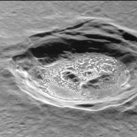
MESSENGER MDIS Release #9 is now available. (2012 day 86 - 2012 day 261)
http://pdsimg.jpl.nasa.gov/index.html Lots of wonderful images like this:
And specific software for quick viewing of this data set:  MessengerViewer.zip ( 277.73K )
Number of downloads: 1729
MessengerViewer.zip ( 277.73K )
Number of downloads: 1729Enjoy. -------------------- Free software for planetary science (including Cassini Image Viewer).
http://members.tripod.com/petermasek/marinerall.html |
|
|
|
|
|
|
Mar 13 2013, 10:52 PM
Post
#27
|
|
|
Merciless Robot Group: Admin Posts: 8785 Joined: 8-December 05 From: Los Angeles Member No.: 602 |
That pic is a jaw-dropper, Peter!
-------------------- A few will take this knowledge and use this power of a dream realized as a force for change, an impetus for further discovery to make less ancient dreams real.
|
|
|
|
|
Mar 14 2013, 05:22 AM
Post
#28
|
|
|
Senior Member Group: Members Posts: 2106 Joined: 13-February 10 From: Ontario Member No.: 5221 |
Absolutely bizarre. And probably the best views we'll get in a long time. Any news about extending the mission past the 17th?
Edit: see http://messenger.jhuapl.edu/gallery/scienc...p;image_id=1115 for reasons for the mission to continue: 100% coverage is just the start.... |
|
|
|
|
Mar 8 2014, 12:08 PM
Post
#29
|
||||
|
Member Group: Members Posts: 568 Joined: 20-April 05 From: Silesia Member No.: 299 |
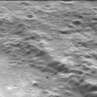
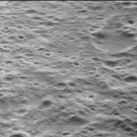
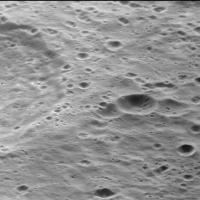
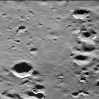
Images from Messenger's narrow angle camera are better and better every batch. If you want to see the surface of Mercury as seen from an airplane window, you can download the latest batch (days 2013-79 to 2013-260) from http://pdsimg.jpl.nasa.gov/index.html, rotate the images 90 degrees to the right, and go on a wonderful journey.
A few randomly selected images (day 2013-189).
-------------------- Free software for planetary science (including Cassini Image Viewer).
http://members.tripod.com/petermasek/marinerall.html |
|||
|
|
|
|||
|
Mar 8 2014, 02:38 PM
Post
#30
|
|||||
|
Member Group: Members Posts: 568 Joined: 20-April 05 From: Silesia Member No.: 299 |
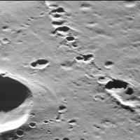
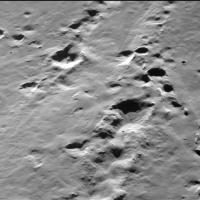
Unique close-up look at the chains of secondary craters. Some look partly buried, it is difficult to say whether immediately after they are created, or later.
Congratulations to the Messenger team for their great job. -------------------- Free software for planetary science (including Cassini Image Viewer).
http://members.tripod.com/petermasek/marinerall.html |
||||
|
|
|
||||
|

|
Lo-Fi Version | Time is now: 25th September 2024 - 05:39 PM |
|
RULES AND GUIDELINES Please read the Forum Rules and Guidelines before posting. IMAGE COPYRIGHT |
OPINIONS AND MODERATION Opinions expressed on UnmannedSpaceflight.com are those of the individual posters and do not necessarily reflect the opinions of UnmannedSpaceflight.com or The Planetary Society. The all-volunteer UnmannedSpaceflight.com moderation team is wholly independent of The Planetary Society. The Planetary Society has no influence over decisions made by the UnmannedSpaceflight.com moderators. |
SUPPORT THE FORUM Unmannedspaceflight.com is funded by the Planetary Society. Please consider supporting our work and many other projects by donating to the Society or becoming a member. |
|