The Top of Vera Rubin Ridge Part 1, Site 66-67, sol 1812-1943, 11 Sep 2017-23 Jan 2018 |

  |
The Top of Vera Rubin Ridge Part 1, Site 66-67, sol 1812-1943, 11 Sep 2017-23 Jan 2018 |
 Nov 15 2017, 12:04 AM Nov 15 2017, 12:04 AM
Post
#151
|
||||
|
Member  Group: Members Posts: 866 Joined: 15-March 05 From: Santa Cruz, CA Member No.: 196 |
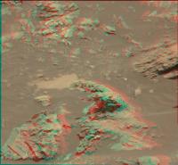
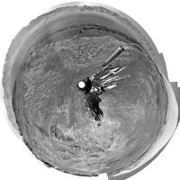
Tafoni-esque weathering due to differential cementation? nice example of a bedrock remnant here in stereo (anaglyph/cross/parellel) from sol1870 M34/m100 pair (debayered via G'MIC in GIMP).
|
|||
 |
 
|
|||
|
Nov 15 2017, 06:49 PM
Post
#152
|
|
|
Member Group: Members Posts: 146 Joined: 31-October 08 Member No.: 4473 |
Are the sediments Curiosity is among still nearly level on the average, or are they dipping towards the rim?
|
|
|
|
|
Nov 16 2017, 10:11 AM
Post
#153
|
||
 Senior Member Group: Members Posts: 2428 Joined: 30-January 13 From: Penang, Malaysia. Member No.: 6853 |
Sol 1876 RMI mosaic (MS ICE), possibly the dark-toned pebble dubbed "Middleton" referenced in the latest mission update
|
|
|
|
|
|
|
Nov 17 2017, 02:18 AM
Post
#154
|
|
|
Senior Member Group: Members Posts: 2428 Joined: 30-January 13 From: Penang, Malaysia. Member No.: 6853 |
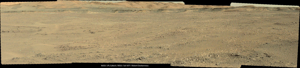
Curiosity completes another drive on sol 1877, its last drive before Thanksgiving. We don't have the post drive images yet, but Midnight Planets is reporting it as ~20.2m Southwest (-143º)
|
|
|
|
|
Nov 17 2017, 11:02 PM
Post
#155
|
||
|
Senior Member Group: Members Posts: 2820 Joined: 22-April 05 From: Ridderkerk, Netherlands Member No.: 353 |
The Navcam L view on Sol 1877.
Jan van Driel
|
|
|
|
|
|
|
Nov 18 2017, 08:02 AM
Post
#156
|
||
|
Senior Member Group: Members Posts: 2428 Joined: 30-January 13 From: Penang, Malaysia. Member No.: 6853 |
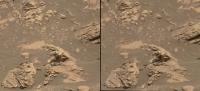
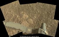
Nice NavCam Pan Jan
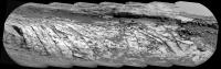
 Here's the Arm Workspace for Sol 1877 L-Mastcam MS ICE / Raw Really nice facets on the sections of exposed bedrock? I guess there is a proper name for that sort of erosional feature, but they look cool whatever they're called
|
|
|
|
|
|
|
Nov 18 2017, 06:29 PM
Post
#157
|
|
|
Senior Member Group: Members Posts: 1074 Joined: 21-September 07 From: Québec, Canada Member No.: 3908 |
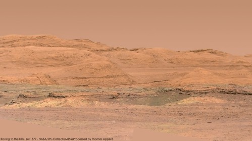
Sol 1877 Lmastcam view:
|
|
|
|
|
Nov 18 2017, 06:39 PM
Post
#158
|
|||
|
Solar System Cartographer Group: Members Posts: 10151 Joined: 5-April 05 From: Canada Member No.: 227 |
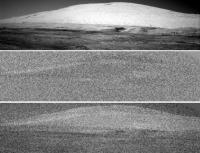
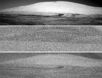
On sol 1878 a set of images were taken by the Right Navcam looking at the mountain to search for changes (dust devils etc.) No dust devils are obvious in them but there is an interesting change.
There are 5 images in the set. Images 4 and 5 show a significant change, a band crossing the mountain:
In this image the top is the raw Navcam (5th image). The middle is a VERY extreme contrast stretch of the difference between 4 and 5, showing a white band. The white is not significant - it would be dark if I did the comparison the other way round, so it only serves to identify an area of change. The bottom overlays the difference on the raw image to show where the difference is. Doing the same with images 3 and 4 gives this:
The white band has moved - in time order it moves from the top of the ridge down towards the rover. There are possibly other subtle changes in the middle distance. Images 1 and 2, and 2 and 3, also show extremely subtle changes which might be real. The change might be on or near the surface - a puff of dust picked up by wind - or it might be caused by moving cloud shadows. Phil -------------------- ... because the Solar System ain't gonna map itself.
Also to be found posting similar content on https://mastodon.social/@PhilStooke Maps for download (free PD: https://upload.wikimedia.org/wikipedia/comm...Cartography.pdf NOTE: everything created by me which I post on UMSF is considered to be in the public domain (NOT CC, public domain) |
||
|
|
|
||
|
Nov 18 2017, 06:55 PM
Post
#159
|
||
|
Solar System Cartographer Group: Members Posts: 10151 Joined: 5-April 05 From: Canada Member No.: 227 |
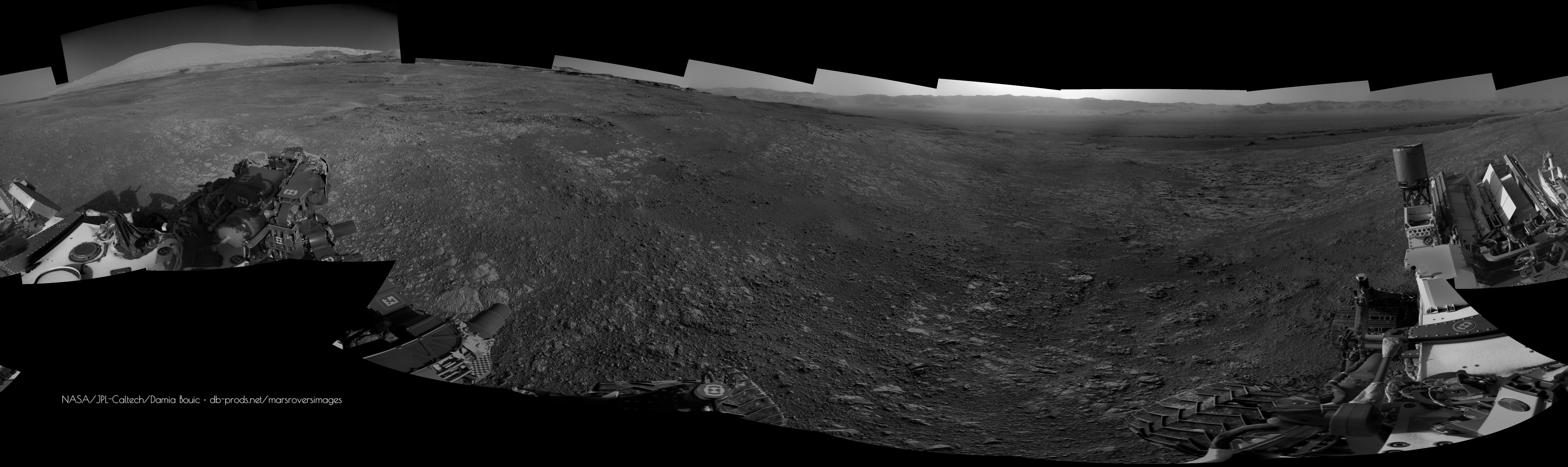
And Jan's sol 1877 panorama in circular form. Interesting that the top of the ridge here has a gravelly surface, quite different from the bare fractured rock on the lower terraces. In HiRISE it looks very bland.
Phil
-------------------- ... because the Solar System ain't gonna map itself.
Also to be found posting similar content on https://mastodon.social/@PhilStooke Maps for download (free PD: https://upload.wikimedia.org/wikipedia/comm...Cartography.pdf NOTE: everything created by me which I post on UMSF is considered to be in the public domain (NOT CC, public domain) |
|
|
|
|
|
|
Nov 18 2017, 10:56 PM
Post
#160
|
||
 Senior Member Group: Members Posts: 4246 Joined: 17-January 05 Member No.: 152 |
QUOTE (Phil Stooke @ Nov 18 2017, 07:39 PM)  The white band has moved - in time order it moves from the top of the ridge down towards the rover. I've noticed similar things before. Here's an example from 1787 (which I never posted back then) where you can clearly see dark/light bands moving up the slopes:
I agree broad gusts or cloud shadows are likely to blame. |
|
|
|
|
|
|
Nov 18 2017, 11:13 PM
Post
#161
|
|||
|
Senior Member Group: Members Posts: 2428 Joined: 30-January 13 From: Penang, Malaysia. Member No.: 6853 |
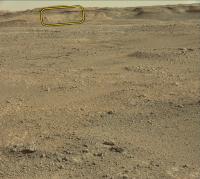
Rough and ready stitch of a set of 10 sol 1979 RMI's that feature a distant target seen on this mast cam frame from charborob's 1877 mosaic.
The images are unprocessed except for stitching.
|
||
|
|
|
||
|
Nov 18 2017, 11:14 PM
Post
#162
|
|
|
Senior Member Group: Members Posts: 2428 Joined: 30-January 13 From: Penang, Malaysia. Member No.: 6853 |
QUOTE (fredk @ Nov 19 2017, 06:56 AM) I agree broad gusts or cloud shadows are likely to blame. Well spotted guys
|
|
|
|
|
Nov 19 2017, 11:02 AM
Post
#163
|
|
 Senior Member Group: Members Posts: 1619 Joined: 12-February 06 From: Bergerac - FR Member No.: 678 |
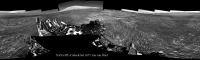
Sol 1877 Navcam panorama. The softness of late afternoons landscapes
-------------------- |
|
|
|
|
Nov 19 2017, 11:47 AM
Post
#164
|
||
|
Senior Member Group: Members Posts: 2428 Joined: 30-January 13 From: Penang, Malaysia. Member No.: 6853 |
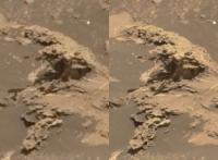
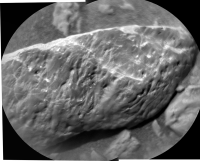
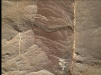
Interface of two rock types? or alteration zone (groundwater from the larger fracture?)
Raw Sol 1879 MAHLI (1879MH0002990010702448C00_DXXX) Many more fine examples of dark and light toned targets examined by the MAHLI here
|
|
|
|
|
|
|
Nov 20 2017, 07:56 AM
Post
#165
|
|
 Member Group: Members Posts: 809 Joined: 3-June 04 From: Brittany, France Member No.: 79 |
Mosaic of two debayered MC100 photos, showing nice details on the distant hills.
-------------------- |
|
|
|
|

|
Lo-Fi Version | Time is now: 26th April 2024 - 04:29 PM |
|
RULES AND GUIDELINES Please read the Forum Rules and Guidelines before posting. IMAGE COPYRIGHT |
OPINIONS AND MODERATION Opinions expressed on UnmannedSpaceflight.com are those of the individual posters and do not necessarily reflect the opinions of UnmannedSpaceflight.com or The Planetary Society. The all-volunteer UnmannedSpaceflight.com moderation team is wholly independent of The Planetary Society. The Planetary Society has no influence over decisions made by the UnmannedSpaceflight.com moderators. |
SUPPORT THE FORUM Unmannedspaceflight.com is funded by the Planetary Society. Please consider supporting our work and many other projects by donating to the Society or becoming a member. |
|