Enceladus 3d |

 Unmanned Spaceflight.com > Outer Solar System > Saturn > Cassini Huygens > Cassini's ongoing mission and raw images
Enceladus 3d |
 Jul 22 2005, 05:53 PM Jul 22 2005, 05:53 PM
Post
#1
|
||||
|
Junior Member  Group: Members Posts: 61 Joined: 5-June 05 From: 46.283N 11.433E :)) Member No.: 401 |
Hi,
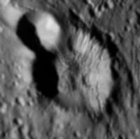
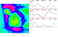
I'm always been a lurker here.  This is a great forum! Thanx to all! This is a great forum! Thanx to all!  I've written a small script in Python that extract the elevation map from an image with lights and shadows. It's a technic called "shape from shading" or photoclinometry. I've applied a simplified algorythm that works only with particular conditions. For example light must come exactly from left to right. It works well only with no patterned images and output images are affected by a boring striped pattern.  Btw, I've worked on an Enceladus crater an this is the result. 3D rendering is by GRASS software. In attachments there are the image of the crater, the 3D image and a map with profiles. ale
|
|||
 |
 
|
|||
 malgar Enceladus 3d Jul 22 2005, 05:53 PM
 malgar I was forgetting a BIG thanx to slinted that had f... Jul 22 2005, 06:03 PM JRehling QUOTE (malgar @ Jul 22 2005, 10:53 AM)Hi,
I... Jul 22 2005, 06:28 PM
malgar I was forgetting a BIG thanx to slinted that had f... Jul 22 2005, 06:03 PM JRehling QUOTE (malgar @ Jul 22 2005, 10:53 AM)Hi,
I... Jul 22 2005, 06:28 PM
 malgar QUOTE (JRehling @ Jul 22 2005, 08:28 PM)produ... Jul 22 2005, 07:47 PM Bjorn Jonsson This is absolutely fantastic, I'm especially i... Jul 22 2005, 08:19 PM malgar QUOTE (Bjorn Jonsson @ Jul 22 2005, 10:19 PM)... Jul 22 2005, 08:46 PM JRehling QUOTE (malgar @ Jul 22 2005, 12:47 PM)Like th... Jul 24 2005, 02:46 AM DrShank Hi guys,
nice work! Ive finally posted severa... Mar 27 2008, 02:07 PM ugordan QUOTE (DrShank @ Mar 27 2008, 03:07 PM) I... Mar 27 2008, 02:30 PM DrShank QUOTE (ugordan @ Mar 27 2008, 09:30 AM) N... Mar 27 2008, 02:41 PM elakdawalla Neato, Paul! Would you happen to have anaglyp... Mar 27 2008, 04:14 PM DrShank QUOTE (elakdawalla @ Mar 27 2008, 10:14 A... Mar 27 2008, 04:33 PM DrShank QUOTE (elakdawalla @ Mar 27 2008, 10:14 A... Mar 27 2008, 04:42 PM Bjorn Jonsson This looks fantastic. If it's not asking too m... Mar 27 2008, 11:50 PM
malgar QUOTE (JRehling @ Jul 22 2005, 08:28 PM)produ... Jul 22 2005, 07:47 PM Bjorn Jonsson This is absolutely fantastic, I'm especially i... Jul 22 2005, 08:19 PM malgar QUOTE (Bjorn Jonsson @ Jul 22 2005, 10:19 PM)... Jul 22 2005, 08:46 PM JRehling QUOTE (malgar @ Jul 22 2005, 12:47 PM)Like th... Jul 24 2005, 02:46 AM DrShank Hi guys,
nice work! Ive finally posted severa... Mar 27 2008, 02:07 PM ugordan QUOTE (DrShank @ Mar 27 2008, 03:07 PM) I... Mar 27 2008, 02:30 PM DrShank QUOTE (ugordan @ Mar 27 2008, 09:30 AM) N... Mar 27 2008, 02:41 PM elakdawalla Neato, Paul! Would you happen to have anaglyp... Mar 27 2008, 04:14 PM DrShank QUOTE (elakdawalla @ Mar 27 2008, 10:14 A... Mar 27 2008, 04:33 PM DrShank QUOTE (elakdawalla @ Mar 27 2008, 10:14 A... Mar 27 2008, 04:42 PM Bjorn Jonsson This looks fantastic. If it's not asking too m... Mar 27 2008, 11:50 PM  |

|
Lo-Fi Version | Time is now: 19th May 2024 - 03:14 PM |
|
RULES AND GUIDELINES Please read the Forum Rules and Guidelines before posting. IMAGE COPYRIGHT |
OPINIONS AND MODERATION Opinions expressed on UnmannedSpaceflight.com are those of the individual posters and do not necessarily reflect the opinions of UnmannedSpaceflight.com or The Planetary Society. The all-volunteer UnmannedSpaceflight.com moderation team is wholly independent of The Planetary Society. The Planetary Society has no influence over decisions made by the UnmannedSpaceflight.com moderators. |
SUPPORT THE FORUM Unmannedspaceflight.com is funded by the Planetary Society. Please consider supporting our work and many other projects by donating to the Society or becoming a member. |
|