Updated Titan Map |

  |
Updated Titan Map |
 Jul 16 2018, 05:54 PM Jul 16 2018, 05:54 PM
Post
#241
|
|
 Member  Group: Members Posts: 120 Joined: 26-May 15 From: Rome - Italy Member No.: 7482 |
QUOTE (Ian R @ Jul 15 2018, 08:38 AM)  And this one might be of interest to Daniele  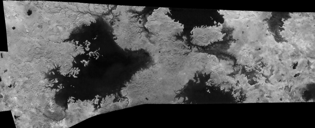 Titan: Ligeia Mare and environs (T-28, T-29, T-25, T-104) [attachment=43208:Ligeia_2018.jpg] You are fantastic Ian R. If I had time I would do every possible lake of Titano .. probably I'll do Ontario Lacus or Kraken MAre. |
 |
 
|
|
Jul 16 2018, 06:16 PM
Post
#242
|
|
 Member Group: Members Posts: 655 Joined: 22-January 06 Member No.: 655 |
At the risk of not actually adding anything to the discussion, I concur. These are fabulously clear views - congratulations to all for the hard work.
|
|
|
|
|
Jul 16 2018, 06:35 PM
Post
#243
|
|
 Director of Galilean Photography Group: Members Posts: 896 Joined: 15-July 04 From: Austin, TX Member No.: 93 |
Amazing work Ian, looks like we are flying over it! Ligeia looks to my like a Gryphon or large bird.
-------------------- Space Enthusiast Richard Hendricks
-- "The engineers, as usual, made a tremendous fuss. Again as usual, they did the job in half the time they had dismissed as being absolutely impossible." --Rescue Party, Arthur C Clarke Mother Nature is the final inspector of all quality. |
|
|
|
|
Jul 20 2018, 04:19 AM
Post
#244
|
|
|
Newbie Group: Members Posts: 3 Joined: 6-August 15 Member No.: 7707 |
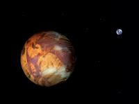
Seeing Titan with Infrared Eyes
https://photojournal.jpl.nasa.gov/catalog/PIA21923 Is it possible we will get a map version of this? |
|
|
|
|
Jul 20 2018, 04:09 PM
Post
#245
|
|
|
Solar System Cartographer Group: Members Posts: 10151 Joined: 5-April 05 From: Canada Member No.: 227 |
You have to have it as a map before it can be rendered as a spherical view. Eventually it will be released.
Phil -------------------- ... because the Solar System ain't gonna map itself.
Also to be found posting similar content on https://mastodon.social/@PhilStooke Maps for download (free PD: https://upload.wikimedia.org/wikipedia/comm...Cartography.pdf NOTE: everything created by me which I post on UMSF is considered to be in the public domain (NOT CC, public domain) |
|
|
|
|
Mar 25 2019, 07:52 PM
Post
#246
|
|
|
Solar System Cartographer Group: Members Posts: 10151 Joined: 5-April 05 From: Canada Member No.: 227 |
Mind-boggling experience follws:
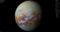
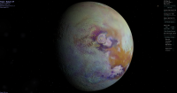
https://data.caltech.edu/records/1173 A merged VIMS-ISS map of Titan. It is similar to the map projected into globes above. Phil -------------------- ... because the Solar System ain't gonna map itself.
Also to be found posting similar content on https://mastodon.social/@PhilStooke Maps for download (free PD: https://upload.wikimedia.org/wikipedia/comm...Cartography.pdf NOTE: everything created by me which I post on UMSF is considered to be in the public domain (NOT CC, public domain) |
|
|
|
|
Mar 25 2019, 08:36 PM
Post
#247
|
|
 Senior Member Group: Members Posts: 2530 Joined: 20-April 05 Member No.: 321 |
That is really nice! Minimizes the seams and artifacts about as well as one could ask for given uneven coverage in the original data. Among other things, I really appreciate the way that Xanadu stands apart from the bright (but not AS bright) terrain to its south and east.
|
|
|
|
|
Mar 26 2019, 07:55 PM
Post
#248
|
|
|
Senior Member Group: Members Posts: 3516 Joined: 4-November 05 From: North Wales Member No.: 542 |
A splendid map indeed. I hope somebody decides to manufacture globes based on that.
|
|
|
|
|
Mar 27 2019, 02:20 AM
Post
#249
|
|||
|
Member Group: Members Posts: 890 Joined: 18-November 08 Member No.: 4489 |
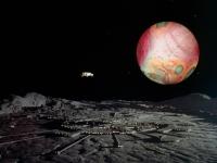
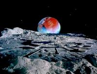
not a real globe but a screenshot
|
||
|
|
|
||
|
Mar 27 2019, 08:13 AM
Post
#250
|
|
|
Senior Member Group: Members Posts: 3516 Joined: 4-November 05 From: North Wales Member No.: 542 |
Very nice. Where do you get the relief information to generate the shading in those views?
|
|
|
|
|
Mar 27 2019, 02:17 PM
Post
#251
|
|
|
Member Group: Members Posts: 890 Joined: 18-November 08 Member No.: 4489 |
the height data from the SAR footprints closely match the black and white imaging data on a large scale
and seeing as there is no shadowing in the images i used that map( not the new colored map above) as a base to make a normal map there is a tool for celestia that correctly maps the normals to a sphere ( called "nms" ) but more on that is for the image processing forum |
|
|
|
|
Mar 27 2019, 08:47 PM
Post
#252
|
|
|
Senior Member Group: Members Posts: 3516 Joined: 4-November 05 From: North Wales Member No.: 542 |
That's as much explanation as I was hoping for, much appreciated. The results are beautiful and entirely plausible.
|
|
|
|
|
Mar 28 2019, 07:36 AM
Post
#253
|
||||
 Senior Member Group: Members Posts: 1084 Joined: 19-February 05 From: Close to Meudon Observatory in France Member No.: 172 |
Thanks a lot JohnVV.
Your renderings are very nice indeed and make Titan looks like a planet taken from our sci-fi TV series of the 60's or 70's (Star Trek and Space : 1999)
|
|||
|
|
|
|||
|
Feb 6 2020, 01:08 PM
Post
#254
|
||
 Junior Member Group: Members Posts: 43 Joined: 14-December 12 Member No.: 6784 |
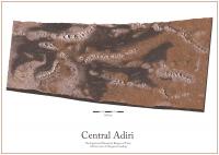
I have made an impressionist map of a segment of the T8 radar swath including several of the mountains ridges of central Adiri. The topography is greatly exaggerated for illustrative purposes.
https://www.astro.rug.nl/~oberg/central_adiri.jpg I used the following sources to help inform the illustration: - Jason Perry's Titan RADAR SAR Swath's website - Ian Regan's ISS global map - Lopes et al. 2019 "A global geomorphologic map of Saturns moon Titan" - Radebaugh et al. 2007 "Mountains on Titan Observed by Cassini Radar" - Liu et al. 2015 "The tectonics of Titan: Global structural mapping from Cassini RADAR" Please let me know if anything goes too far beyond artistic liberties and could stand to be corrected. - Nick Oberg
Attached thumbnail(s)
|
|
|
|
|
|
|
Feb 6 2020, 05:35 PM
Post
#255
|
|
|
Solar System Cartographer Group: Members Posts: 10151 Joined: 5-April 05 From: Canada Member No.: 227 |
That's a beautiful piece of work. I hope we will see more!
Phil -------------------- ... because the Solar System ain't gonna map itself.
Also to be found posting similar content on https://mastodon.social/@PhilStooke Maps for download (free PD: https://upload.wikimedia.org/wikipedia/comm...Cartography.pdf NOTE: everything created by me which I post on UMSF is considered to be in the public domain (NOT CC, public domain) |
|
|
|
|

|
Lo-Fi Version | Time is now: 26th April 2024 - 03:42 AM |
|
RULES AND GUIDELINES Please read the Forum Rules and Guidelines before posting. IMAGE COPYRIGHT |
OPINIONS AND MODERATION Opinions expressed on UnmannedSpaceflight.com are those of the individual posters and do not necessarily reflect the opinions of UnmannedSpaceflight.com or The Planetary Society. The all-volunteer UnmannedSpaceflight.com moderation team is wholly independent of The Planetary Society. The Planetary Society has no influence over decisions made by the UnmannedSpaceflight.com moderators. |
SUPPORT THE FORUM Unmannedspaceflight.com is funded by the Planetary Society. Please consider supporting our work and many other projects by donating to the Society or becoming a member. |
|