Atop/Around the Greenheugh Pediment, Site 79-, sol 2695-3199, 3 Mar 2020-6 Aug 2021 |

Atop/Around the Greenheugh Pediment, Site 79-, sol 2695-3199, 3 Mar 2020-6 Aug 2021 |
 Mar 6 2020, 04:33 PM Mar 6 2020, 04:33 PM
Post
#1
|
||
 Senior Member  Group: Members Posts: 2428 Joined: 30-January 13 From: Penang, Malaysia. Member No.: 6853 |
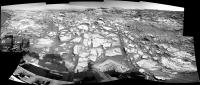
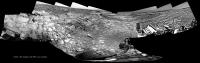
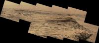
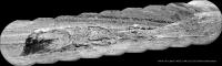
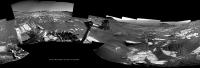
Sol 2695: Just a short drive / climb, but a very welcome one to get all 6 wheels off the slope and onto the top of the pediment
 Roughly stitched L-NavCam partial pan using MS-ICE with the available images. I'm sure the full 360 will be memorable... BTW: maybe a good time for a new thread? (Traversing the Greenheugh Pediment?)
|
|
 |
 
|
|
 |
|
Mar 7 2020, 03:32 AM
Post
#2
|
|
|
Member Group: Members Posts: 923 Joined: 10-November 15 Member No.: 7837 |
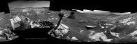
Some context shots with a roughly scaled Curiosity perched on the edge of Greenheugh...
  ...grabbed from my 1.8 billion pixel Traverse map. -------------------- |
|
|
|
|
Mar 7 2020, 05:53 AM
Post
#3
|
|
|
Merciless Robot Group: Admin Posts: 8784 Joined: 8-December 05 From: Los Angeles Member No.: 602 |
Stunning, Sean.
 Re new thread: Yeah, possibly. That's Emily's call, though; she's been most carefully curating the journey of MSL here.
-------------------- A few will take this knowledge and use this power of a dream realized as a force for change, an impetus for further discovery to make less ancient dreams real.
|
|
|
|
|
Mar 7 2020, 10:01 AM
Post
#4
|
||
|
Senior Member Group: Members Posts: 2830 Joined: 22-April 05 From: Ridderkerk, Netherlands Member No.: 353 |
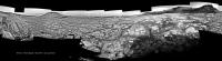
The Navcam L view on Sol 2695.
Jan van Driel
|
|
|
|
|
|
|
Mar 7 2020, 06:07 PM
Post
#5
|
||
 Member Group: Members Posts: 684 Joined: 24-July 15 Member No.: 7619 |
QUOTE (Sean @ Mar 7 2020, 04:32 AM)  Some context shots with a roughly scaled Curiosity perched on the edge of Greenheugh... I feel like Lawrence of Arabia fumbling for his binoculars after his guide Tafas shouts "Bedu" - WHERE?
Attached thumbnail(s)
|
|
|
|
|
|
|
Mar 7 2020, 06:46 PM
Post
#6
|
|
|
Member Group: Members Posts: 362 Joined: 13-April 06 From: Malta Member No.: 741 |
Greenheugh pediment looks like its going to be a rough traverse for the rover. What does the pediment represent?
|
|
|
|
|
Mar 7 2020, 10:21 PM
Post
#7
|
||
|
Senior Member Group: Members Posts: 2428 Joined: 30-January 13 From: Penang, Malaysia. Member No.: 6853 |
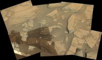
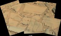
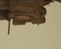
2695 Arm workspace L-MastCam (raw MS-ICE)
|
|
|
|
|
|
|
Mar 8 2020, 12:52 AM
Post
#8
|
||
|
Solar System Cartographer Group: Members Posts: 10163 Joined: 5-April 05 From: Canada Member No.: 227 |
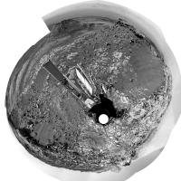
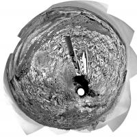
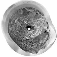
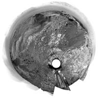
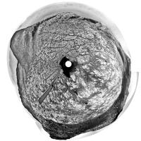
Jan's sol 2695 panorama in circular form.
Phil
-------------------- ... because the Solar System ain't gonna map itself.
Also to be found posting similar content on https://mastodon.social/@PhilStooke Maps for download (free PD: https://upload.wikimedia.org/wikipedia/comm...Cartography.pdf NOTE: everything created by me which I post on UMSF is considered to be in the public domain (NOT CC, public domain) |
|
|
|
|
|
|
Mar 8 2020, 01:11 AM
Post
#9
|
|
|
Solar System Cartographer Group: Members Posts: 10163 Joined: 5-April 05 From: Canada Member No.: 227 |
Julius: "Greenheugh pediment looks like its going to be a rough traverse for the rover. What does the pediment represent?"
Not sure, but you might find this LPSC abstract interesting: https://www.hou.usra.edu/meetings/lpsc2020/pdf/2337.pdf Originally the pediment was interpreted as an alluvial fan, sediment swept down Gediz Vallis by flowing water, but that's not the prevailing view at the moment. Phil -------------------- ... because the Solar System ain't gonna map itself.
Also to be found posting similar content on https://mastodon.social/@PhilStooke Maps for download (free PD: https://upload.wikimedia.org/wikipedia/comm...Cartography.pdf NOTE: everything created by me which I post on UMSF is considered to be in the public domain (NOT CC, public domain) |
|
|
|
|
Mar 8 2020, 05:26 AM
Post
#10
|
|
|
Junior Member Group: Members Posts: 23 Joined: 28-September 17 From: Huntsville, Alabama Member No.: 8258 |
Here's an abstract from 2019 showing in Fig. 4 a projection from the Greenheugh to the Stimson.
https://www.hou.usra.edu/meetings/ninthmars2019/pdf/6296.pdf |
|
|
|
|
Mar 8 2020, 06:17 AM
Post
#11
|
|
|
Member Group: Members Posts: 362 Joined: 13-April 06 From: Malta Member No.: 741 |
Thanks Phil, pbanholzer.appreciated.
|
|
|
|
|
Mar 8 2020, 01:27 PM
Post
#12
|
||
|
Senior Member Group: Members Posts: 1074 Joined: 21-September 07 From: Québec, Canada Member No.: 3908 |
Sol 2695 Lmastcam:
|
|
|
|
|
|
|
Mar 8 2020, 01:32 PM
Post
#13
|
|
|
Senior Member Group: Members Posts: 1074 Joined: 21-September 07 From: Québec, Canada Member No.: 3908 |
How do you pronounce "Greenheugh"? (Not evident for a French speaker.)
|
|
|
|
|
Mar 8 2020, 05:28 PM
Post
#14
|
|
 Senior Member Group: Members Posts: 2173 Joined: 28-December 04 From: Florida, USA Member No.: 132 |
Not evident for an English speaker either!
|
|
|
|
|
Mar 8 2020, 05:54 PM
Post
#15
|
|
|
Founder Group: Chairman Posts: 14432 Joined: 8-February 04 Member No.: 1 |
Everyone Ive heard say it says Green Hue.
|
|
|
|
|
Mar 9 2020, 09:24 AM
Post
#16
|
|
|
Senior Member Group: Members Posts: 2428 Joined: 30-January 13 From: Penang, Malaysia. Member No.: 6853 |
QUOTE (djellison @ Mar 9 2020, 01:54 AM) Everyone Ive heard say it says Green Hue. Concur - Ashwin also uses Green Hue in this recent video https://youtu.be/o12KsNmoMhQ?t=87 |
|
|
|
|
Mar 9 2020, 01:35 PM
Post
#17
|
|
|
Member Group: Members Posts: 923 Joined: 10-November 15 Member No.: 7837 |
Better angle on Greenheugh...
 ...Curi at sol 2695 position. -------------------- |
|
|
|
|
Mar 9 2020, 02:15 PM
Post
#18
|
|
 Member Group: Members Posts: 810 Joined: 3-June 04 From: Brittany, France Member No.: 79 |
Panorama taken with MC Right on sol 2696 merged with two MC Left pictures:

-------------------- |
|
|
|
|
Mar 9 2020, 03:33 PM
Post
#19
|
||
|
Senior Member Group: Members Posts: 2830 Joined: 22-April 05 From: Ridderkerk, Netherlands Member No.: 353 |
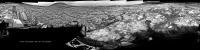
The Navcam L view on Sol 2698.
The rest of the images will be added later. Jan van Driel
|
|
|
|
|
|
|
Mar 10 2020, 12:45 AM
Post
#20
|
||
|
Senior Member Group: Members Posts: 2830 Joined: 22-April 05 From: Ridderkerk, Netherlands Member No.: 353 |
and the Complete Sol 2698 Navcam L view.
Jan van Driel
|
|
|
|
|
|
|
Mar 10 2020, 10:53 AM
Post
#21
|
|
 Senior Member Group: Members Posts: 1619 Joined: 12-February 06 From: Bergerac - FR Member No.: 678 |
Sol 2596 Mastcam100 panoramic.
-------------------- |
|
|
|
|
Mar 10 2020, 10:45 PM
Post
#22
|
||
|
Senior Member Group: Members Posts: 2428 Joined: 30-January 13 From: Penang, Malaysia. Member No.: 6853 |
Really enjoying the expertly de-bayered panoramas posted here. Many thanks...
Here's the raw L-MastCam 2698 arm workspace assembled in MS-ICE
|
|
|
|
|
|
|
Mar 10 2020, 11:42 PM
Post
#23
|
||
|
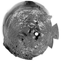
Solar System Cartographer Group: Members Posts: 10163 Joined: 5-April 05 From: Canada Member No.: 227 |
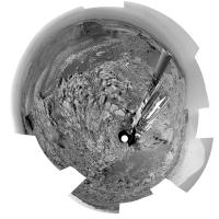
Here is Jan's sol 2698 panorama in circular form. It shows the rugged landscape quite well. This looks like wheel-busting terrain to me.
Phil
-------------------- ... because the Solar System ain't gonna map itself.
Also to be found posting similar content on https://mastodon.social/@PhilStooke Maps for download (free PD: https://upload.wikimedia.org/wikipedia/comm...Cartography.pdf NOTE: everything created by me which I post on UMSF is considered to be in the public domain (NOT CC, public domain) |
|
|
|
|
|
|
Mar 11 2020, 04:42 PM
Post
#24
|
|
 Administrator Group: Admin Posts: 5172 Joined: 4-August 05 From: Pasadena, CA, USA, Earth Member No.: 454 |
Hi folks, new rocks, new thread! Here's a link to the spot in the Route Map thread where Phil et al. documented this moment.
-------------------- My website - My Patreon - @elakdawalla on Twitter - Please support unmannedspaceflight.com by donating here.
|
|
|
|
|
Mar 11 2020, 10:32 PM
Post
#25
|
||
|
Senior Member Group: Members Posts: 2428 Joined: 30-January 13 From: Penang, Malaysia. Member No.: 6853 |
Partial end-of-drive R-Navcam pan from sol 2700 (Site/drive 79-588) hopefully to assist in pinpointing the location while we wait for the remaining frames.
The plan stated they were driving west looking for a drill site... This location appears to tick some of the drill site boxes
|
|
|
|
|
|
|
Mar 12 2020, 12:03 AM
Post
#26
|
|
 Member Group: Members Posts: 214 Joined: 30-December 05 Member No.: 628 |
QUOTE (Ant103 @ Mar 10 2020, 06:53 PM) Sol 2596 Mastcam100 panoramic. Ant, are those images available for download? Am having some trouble figuring out how. Sorry. |
|
|
|
|
Mar 12 2020, 09:04 AM
Post
#27
|
|
|
Senior Member Group: Members Posts: 1619 Joined: 12-February 06 From: Bergerac - FR Member No.: 678 |
@tanjent : which images ? The panoramic ? If that's the case, just follow the link by clicking the picture, you would find a gallery with the image, and links bellow.
Edit : Sol 2700 Navcam panoramic. 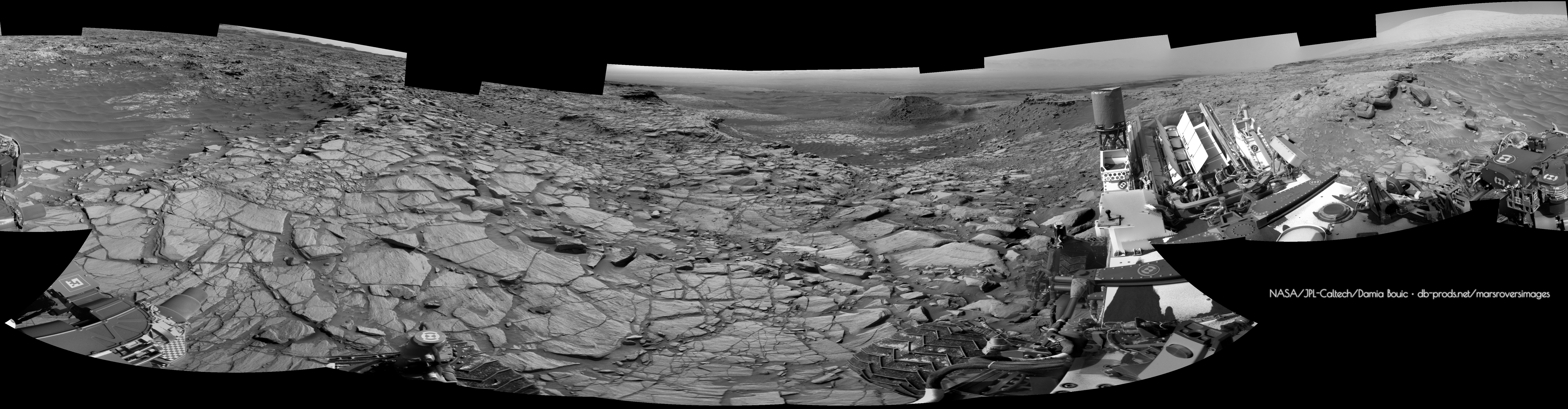
-------------------- |
|
|
|
|
Mar 12 2020, 07:49 PM
Post
#28
|
||
|
Senior Member Group: Members Posts: 2428 Joined: 30-January 13 From: Penang, Malaysia. Member No.: 6853 |
Sol 2699 R-MastCam partial pan of just 30 frames, assembled in MS-ICE, reduced to 5000px wide, debayered, but without further processing
|
|
|
|
|
|
|
Mar 12 2020, 08:37 PM
Post
#29
|
||
|
Solar System Cartographer Group: Members Posts: 10163 Joined: 5-April 05 From: Canada Member No.: 227 |
This is Damia's panorama in circular form - giving a good location for a map update. Thanks, Damia!
Phil
-------------------- ... because the Solar System ain't gonna map itself.
Also to be found posting similar content on https://mastodon.social/@PhilStooke Maps for download (free PD: https://upload.wikimedia.org/wikipedia/comm...Cartography.pdf NOTE: everything created by me which I post on UMSF is considered to be in the public domain (NOT CC, public domain) |
|
|
|
|
|
|
Mar 13 2020, 05:51 AM
Post
#30
|
|
|
Member Group: Members Posts: 184 Joined: 2-March 06 Member No.: 692 |
This is caprock so it might be hard to drill. I hope we get one!
|
|
|
|
|
Mar 13 2020, 06:47 AM
Post
#31
|
||
|
Senior Member Group: Members Posts: 2428 Joined: 30-January 13 From: Penang, Malaysia. Member No.: 6853 |
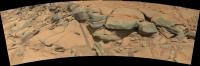
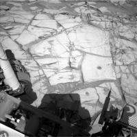
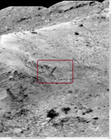
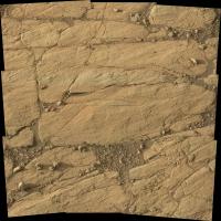
QUOTE (monty python @ Mar 13 2020, 01:51 PM) This is caprock so it might be hard to drill. I hope we get one! It would be nice to see them drill / sample one of those darker (capping) rocks, but because of the Feed Extended Drilling) they would need to find a really stable candidate... However, the first potential drill site candidate appears to be in the lighter toned bedrocks seen in the arm workspace on sol 2700. Attached is a mosaic of the L-MastCam images of that workspace, I believe the candidate is the Trapezoid shaped block in the upper right of the mosaic.
|
|
|
|
|
|
|
Mar 13 2020, 11:15 AM
Post
#32
|
||
|
Senior Member Group: Members Posts: 2428 Joined: 30-January 13 From: Penang, Malaysia. Member No.: 6853 |
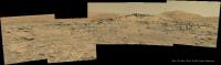
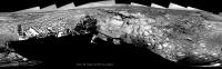
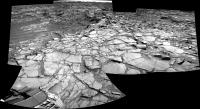
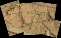
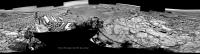
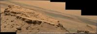
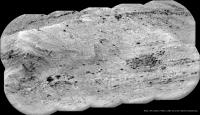
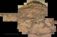
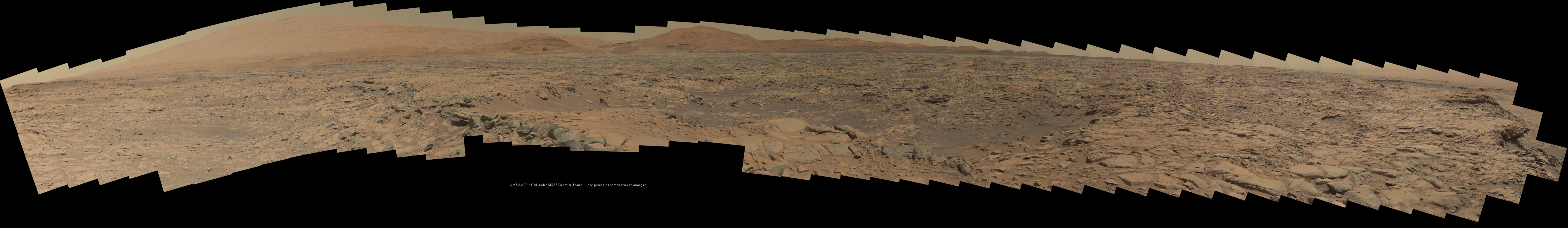
Looking towards the edge of the Greenheugh Pediment and some rather nice strata seen in this R-Mastcam partial pan from sol 2700, debayered in GIMP and stitched using MS-ICE, no additional processing, so apologies for the green hue as I can't find a way of removing it.
|
|
|
|
|
|
|
Mar 13 2020, 01:56 PM
Post
#33
|
||
|
Senior Member Group: Members Posts: 2830 Joined: 22-April 05 From: Ridderkerk, Netherlands Member No.: 353 |
The Navcam L view on Sol 2700.
Jan van Driel
|
|
|
|
|
|
|
Mar 13 2020, 04:17 PM
Post
#34
|
|
|
Senior Member Group: Members Posts: 1619 Joined: 12-February 06 From: Bergerac - FR Member No.: 678 |
Sol 2700 loooooooooooooooooooooooooooooooooooong Mastcam100 mosaic showing a hell of details there.
-------------------- |
|
|
|
|
Mar 14 2020, 03:00 PM
Post
#35
|
||
|
Senior Member Group: Members Posts: 2830 Joined: 22-April 05 From: Ridderkerk, Netherlands Member No.: 353 |
The Navcam L view on Sol 2702.
Jan van Driel
|
|
|
|
|
|
|
Mar 15 2020, 03:34 AM
Post
#36
|
||
|
Senior Member Group: Members Posts: 2428 Joined: 30-January 13 From: Penang, Malaysia. Member No.: 6853 |
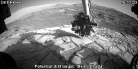
Sol 2703 animated GIF showing the pre-drill (load test) of the potential drill target: 'Beinn Fhada'
Reduced to 800x400px
|
|
|
|
|
|
|
Mar 15 2020, 02:56 PM
Post
#37
|
||
|
Senior Member Group: Members Posts: 2830 Joined: 22-April 05 From: Ridderkerk, Netherlands Member No.: 353 |
The Navcam L view on Sol 2702-2703.
Added 5 images taken on Sol 2703. Jan van Driel
|
|
|
|
|
|
|
Mar 16 2020, 02:46 AM
Post
#38
|
||
|
Solar System Cartographer Group: Members Posts: 10163 Joined: 5-April 05 From: Canada Member No.: 227 |
Jan's newest panorama in circular format:
Phil -------------------- ... because the Solar System ain't gonna map itself.
Also to be found posting similar content on https://mastodon.social/@PhilStooke Maps for download (free PD: https://upload.wikimedia.org/wikipedia/comm...Cartography.pdf NOTE: everything created by me which I post on UMSF is considered to be in the public domain (NOT CC, public domain) |
|
|
|
|
|
|
Mar 17 2020, 03:46 PM
Post
#39
|
||
|
Senior Member Group: Members Posts: 2830 Joined: 22-April 05 From: Ridderkerk, Netherlands Member No.: 353 |
The Mastcam L view on Sol 2699.
Jan van Driel
|
|
|
|
|
|
|
Mar 18 2020, 11:15 AM
Post
#40
|
||
|
Senior Member Group: Members Posts: 2830 Joined: 22-April 05 From: Ridderkerk, Netherlands Member No.: 353 |
The Mastcam L view on Sol 2700.
Jan van Driel
|
|
|
|
|
|
|
Mar 23 2020, 01:15 PM
Post
#41
|
||
|
Senior Member Group: Members Posts: 2428 Joined: 30-January 13 From: Penang, Malaysia. Member No.: 6853 |
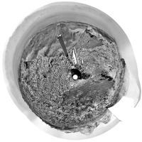
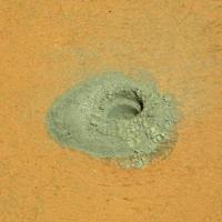
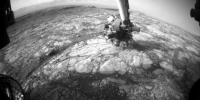
Edinburgh drill hole on sol 2711, judging by the HazCam images acquired during drilling and the tailings shown in this L-NavCam frame there should be a good chance of a viable sample in the sleeve
|
|
|
|
|
|
|
Mar 24 2020, 06:32 PM
Post
#42
|
||
|
Solar System Cartographer Group: Members Posts: 10163 Joined: 5-April 05 From: Canada Member No.: 227 |
Yes, the hole looks good!
Phil -------------------- ... because the Solar System ain't gonna map itself.
Also to be found posting similar content on https://mastodon.social/@PhilStooke Maps for download (free PD: https://upload.wikimedia.org/wikipedia/comm...Cartography.pdf NOTE: everything created by me which I post on UMSF is considered to be in the public domain (NOT CC, public domain) |
|
|
|
|
|
|
Mar 25 2020, 09:57 AM
Post
#43
|
||
|
Senior Member Group: Members Posts: 2830 Joined: 22-April 05 From: Ridderkerk, Netherlands Member No.: 353 |
Partial view of the Mastcam L view on Sol 2711.
Jan van Driel
|
|
|
|
|
|
|
Mar 25 2020, 06:51 PM
Post
#44
|
|||
|
Member Group: Members Posts: 866 Joined: 15-March 05 From: Santa Cruz, CA Member No.: 196 |
Thank you for that nicely debayered and stitched pano of the sol2711 mastcam set. Its quite a view and am especially intrigued by highly eroded sections especially as seen in the snippet of the pano below, representing this pair of snapshots, looking closer a sinuous curve of apparent eroded pediment boundary appears sharply shadowed appearing in the exposure as if it were some sort of slack cable draped over the landscape. I keep losing my bearing as to where we are so have no idea if Curi is heading towards that particular area or onward elsewhere..
|
||
|
|
|
||
|
Mar 25 2020, 08:27 PM
Post
#45
|
|
 Senior Member Group: Members Posts: 4247 Joined: 17-January 05 Member No.: 152 |
We had this MR view of that feature, though with a bit different lighting:
https://mars.nasa.gov/msl-raw-images/msss/0...167C00_DXXX.jpg |
|
|
|
|
Mar 26 2020, 01:06 PM
Post
#46
|
||
|
Senior Member Group: Members Posts: 2428 Joined: 30-January 13 From: Penang, Malaysia. Member No.: 6853 |
Sol 2713 GIF: Sample drop for 'portion characterisation' in this cropped L-MastCam of the powdered rock from the 'Edinburgh' drill site.
|
|
|
|
|
|
|
Mar 27 2020, 11:38 AM
Post
#47
|
||
|
Senior Member Group: Members Posts: 2428 Joined: 30-January 13 From: Penang, Malaysia. Member No.: 6853 |
A long distance 10 frame ChemCam-RMI mosaic of what I believe is a face of Gediz Vallis Ridge, images acquired on sol 2715. Roughly assembled in MS-ICE and annotated, but otherwise unprocessed.
|
|
|
|
|
|
|
Mar 27 2020, 12:11 PM
Post
#48
|
||
|
Senior Member Group: Members Posts: 2428 Joined: 30-January 13 From: Penang, Malaysia. Member No.: 6853 |
Another long distance ChemCam-RMI Mosaic, possibly a basal section of the Gediz Vallis Ridge a little closer to the rover?
Once again from sol 2715, roughly assembled in MS-ICE without additional processing
|
|
|
|
|
|
|
Mar 28 2020, 11:06 AM
Post
#49
|
|
|
Senior Member Group: Members Posts: 1619 Joined: 12-February 06 From: Bergerac - FR Member No.: 678 |
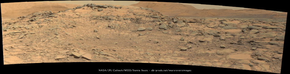
Sol 2711 Mastcam34 panoramic. This is such a beautiful place
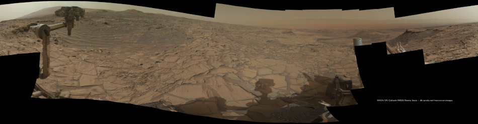 Postcard version : 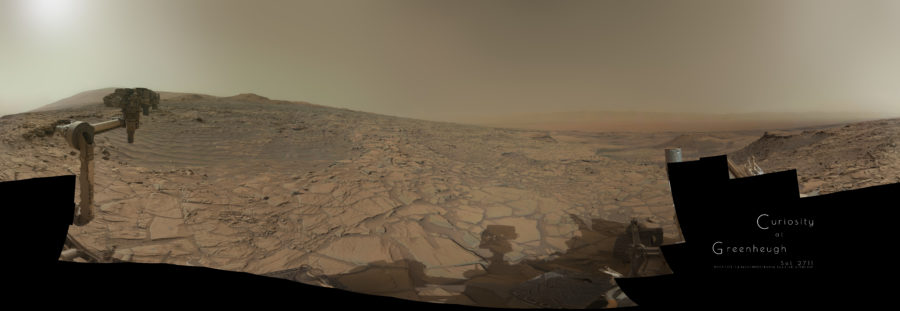
-------------------- |
|
|
|
|
Mar 31 2020, 07:39 AM
Post
#50
|
||
|
Senior Member Group: Members Posts: 2428 Joined: 30-January 13 From: Penang, Malaysia. Member No.: 6853 |
Lovely work Damia, looking forward to seeing more of your excellent panoramas!
Meanwhile, another long distance RMI mosaic across the pediment, this time wider view (19 frames from sol 2719) It was roughly assembled in MS-ICE without additional processing.
|
|
|
|
|
|
|
Mar 31 2020, 08:16 PM
Post
#51
|
|
|
Member Group: Members Posts: 866 Joined: 15-March 05 From: Santa Cruz, CA Member No.: 196 |
Indeed a very lovely view, the composition gives a feeling almost of a Martian sort of tropical, taking in a relatively balmy afternoon as wavelets of sand gently lap up against the near shore and relax sipping a perchlorate cocktail under the instrument cluster standing in as mock parasol, take a glance over near to the right a bit into the distance many barchan dune islands poke above the surface as the seas of sand grow rougher dissappearing into the murky distance, in splendid isolation I will be to remain here for some while..
|
|
|
|
|
Apr 1 2020, 08:02 AM
Post
#52
|
|
 Member Group: Members Posts: 146 Joined: 22-November 14 From: Bormida (SV) - Italy Member No.: 7348 |
Another version of sol 2711 panorama (de-bayer)

-------------------- |
|
|
|
|
Apr 6 2020, 07:48 AM
Post
#53
|
||
|
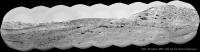
Senior Member Group: Members Posts: 2428 Joined: 30-January 13 From: Penang, Malaysia. Member No.: 6853 |
Yet another long range ChemCam RMI mosaic checking the distant terrain, this one appears to focus on the hills beyond the Greenheugh Pediment. Images from Sol 2725, composed of 12 frames assembled in MS-ICE without further processing. Note, there appears to be 14 images in this sequence, but one processed frame has not made it to the server as of the time of this post.
|
|
|
|
|
|
|
Apr 6 2020, 08:09 AM
Post
#54
|
|
|
Senior Member Group: Members Posts: 1044 Joined: 17-February 09 Member No.: 4605 |
I may be a tad bidirectionally challenged, but isn't that the marker bed?
|
|
|
|
|
Apr 6 2020, 11:30 AM
Post
#55
|
||
|
Senior Member Group: Members Posts: 2428 Joined: 30-January 13 From: Penang, Malaysia. Member No.: 6853 |
QUOTE (serpens @ Apr 6 2020, 04:09 PM) I may be a tad bidirectionally challenged, but isn't that the marker bed? I'm not sure, but I'm guessing you are referring to the 'marker bed' described in this? link Here's where I think the terrain is, I've added a box to a mosaic assemble by Neville Thomson showing the other long range RMIs from atop the pediment link
Edit: We now have the mission update that covers this sol: QUOTE On the second sol Curiosity will take a ChemCam long distance RMI mosaic of the pediment capping unit to assess the stratigraphy and sedimentary structures exposed on the flank of Gediz Vallis.
|
|
|
|
|
|
|
Apr 6 2020, 04:12 PM
Post
#56
|
|||
|
Senior Member Group: Members Posts: 1074 Joined: 21-September 07 From: Québec, Canada Member No.: 3908 |
Two long-distance RMI panoramas taken on sol 2723:
|
||
|
|
|
||
|
Apr 7 2020, 09:30 AM
Post
#57
|
||
|
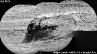
Senior Member Group: Members Posts: 2428 Joined: 30-January 13 From: Penang, Malaysia. Member No.: 6853 |
QUOTE (atomoid @ Mar 26 2020, 02:51 AM) ...especially intrigued by highly eroded sections especially as seen in the snippet of the pano below, representingt... looking closer a sinuous curve of apparent eroded pediment boundary appears sharply shadowed appearing in the exposure as if it were some sort of slack cable draped over the landscape. I keep losing my bearing as to where we are so have no idea if Curi is heading towards that particular area or onward elsewhere.. Here's a little more detail in this telephoto ChemCam-RMI from Sol 2726, roughly assembled in MS-ICE, some data drop out in one frame. No additional processing except the stitch and adding the text.
|
|
|
|
|
|
|
Apr 9 2020, 01:24 PM
Post
#58
|
||
|
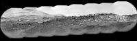
Senior Member Group: Members Posts: 2428 Joined: 30-January 13 From: Penang, Malaysia. Member No.: 6853 |
Yet another long range RMI mosaic, I can't recall so many of these being acquired from one location.
This one is from Sol 2728, assembled in MS-ICE
|
|
|
|
|
|
|
Apr 9 2020, 03:34 PM
Post
#59
|
|||
|
Senior Member Group: Members Posts: 1074 Joined: 21-September 07 From: Québec, Canada Member No.: 3908 |
Two long-range RMI mosaics taken on sol 2726:
|
||
|
|
|
||
|
Apr 9 2020, 03:45 PM
Post
#60
|
||
|
Senior Member Group: Members Posts: 1074 Joined: 21-September 07 From: Québec, Canada Member No.: 3908 |
A second long-range RMI mosaic from sol 2728:
|
|
|
|
|
|
|
Apr 10 2020, 10:47 AM
Post
#61
|
|
|
Senior Member Group: Members Posts: 1619 Joined: 12-February 06 From: Bergerac - FR Member No.: 678 |
Quoting myself because this panorama is finally over. I missed one frame to complete it, and this frame was available tonight. So
QUOTE (Ant103 @ Mar 13 2020, 06:17 PM) Sol 2700 loooooooooooooooooooooooooooooooooooong Mastcam100 mosaic showing a hell of details there. -------------------- |
|
|
|
|
Apr 11 2020, 12:09 AM
Post
#62
|
|
|
Junior Member Group: Members Posts: 95 Joined: 11-January 07 From: Amsterdam Member No.: 1584 |
new navcams! and why not view them in the latest version of my navcam viewer?
https://captainvideo.nl/rob/navcamdiary.html press tab or the topright circle for a sol list press h for other options stay safe, all of you! -------------------- |
|
|
|
|
Apr 11 2020, 12:59 AM
Post
#63
|
||
|
Senior Member Group: Members Posts: 1074 Joined: 21-September 07 From: Québec, Canada Member No.: 3908 |
Sol 2729 long-range RMI mosaic:
|
|
|
|
|
|
|
Apr 11 2020, 01:50 AM
Post
#64
|
|||
|
Member Group: Members Posts: 684 Joined: 24-July 15 Member No.: 7619 |
QUOTE (charborob @ Apr 9 2020, 04:45 PM) A second long-range RMI mosaic from sol 2728:
Do we have another "spoon" of suspended rock in that RMI? Like what we saw around Sol 1070-1089?
Attached thumbnail(s)
|
||
|
|
|
||
|
Apr 11 2020, 12:06 PM
Post
#65
|
|
|
Member Group: Members Posts: 810 Joined: 3-June 04 From: Brittany, France Member No.: 79 |
-------------------- |
|
|
|
|
Apr 11 2020, 01:11 PM
Post
#66
|
||
|
Senior Member Group: Members Posts: 2830 Joined: 22-April 05 From: Ridderkerk, Netherlands Member No.: 353 |
The Navcam L view on Sol 2729.
Jan van Driel
|
|
|
|
|
|
|
Apr 11 2020, 06:29 PM
Post
#67
|
||
|
Solar System Cartographer Group: Members Posts: 10163 Joined: 5-April 05 From: Canada Member No.: 227 |
Thanks, Jan. Here is a circular view of it showing how we have moved away from the edge of that depression. The recent updates have indicated we will drive off the pediment and resume the previous path around its edge to the east, then up into the hills.
Phil
-------------------- ... because the Solar System ain't gonna map itself.
Also to be found posting similar content on https://mastodon.social/@PhilStooke Maps for download (free PD: https://upload.wikimedia.org/wikipedia/comm...Cartography.pdf NOTE: everything created by me which I post on UMSF is considered to be in the public domain (NOT CC, public domain) |
|
|
|
|
|
|
Apr 13 2020, 01:58 PM
Post
#68
|
||
|
Senior Member Group: Members Posts: 2830 Joined: 22-April 05 From: Ridderkerk, Netherlands Member No.: 353 |
The Mastcam L view on Sol 2729.
Jan van Driel
|
|
|
|
|
|
|
Apr 13 2020, 06:03 PM
Post
#69
|
||
|
Senior Member Group: Members Posts: 2830 Joined: 22-April 05 From: Ridderkerk, Netherlands Member No.: 353 |
The Navcam L view on Sol 2732.
Jan van Driel
|
|
|
|
|
|
|
Apr 14 2020, 03:33 PM
Post
#70
|
|
|
Member Group: Members Posts: 810 Joined: 3-June 04 From: Brittany, France Member No.: 79 |
My take on the MastCam Right mosaic of sol 2729, with 5 extra Matt Damon added to give a scale
 The furthest one is at ~580m from Curiosity rover. 
-------------------- |
|
|
|
|
Apr 14 2020, 08:35 PM
Post
#71
|
||
|
Solar System Cartographer Group: Members Posts: 10163 Joined: 5-April 05 From: Canada Member No.: 227 |
Don't jump, Matt! There's still hope for a sequel!
Also, here is Jan's new panorama in circular form. We have moved right to the edge of the pediment again at the same place we climbed it earlier. The tracks are visible just below us. Phil
-------------------- ... because the Solar System ain't gonna map itself.
Also to be found posting similar content on https://mastodon.social/@PhilStooke Maps for download (free PD: https://upload.wikimedia.org/wikipedia/comm...Cartography.pdf NOTE: everything created by me which I post on UMSF is considered to be in the public domain (NOT CC, public domain) |
|
|
|
|
|
|
Apr 14 2020, 10:09 PM
Post
#72
|
|
|
Senior Member Group: Members Posts: 1044 Joined: 17-February 09 Member No.: 4605 |
Found Wally. Thanks for the humour neo.
|
|
|
|
|
Apr 15 2020, 12:22 AM
Post
#73
|
|
|
Member Group: Members Posts: 866 Joined: 15-March 05 From: Santa Cruz, CA Member No.: 196 |
Thanks neo56 for the great image treatment, i inspected jvandiel's stitch of the same sequence yesterday and was frustrated trying to get a handle on the scale of things, and since i tend to overestimate the scale of things in the near-scope pancams, i now see im overcompensating for the larger scale sequences, i so misunderestimated that protruding part of the rock to be only about the size of Mark Watney's boot, off by over 3x..
|
|
|
|
|
Apr 15 2020, 06:43 PM
Post
#74
|
||
|
Senior Member Group: Members Posts: 2830 Joined: 22-April 05 From: Ridderkerk, Netherlands Member No.: 353 |
The Navcam L view on Sol 2734.
Jan van Driel
|
|
|
|
|
|
|
Apr 15 2020, 08:16 PM
Post
#75
|
||
|
Solar System Cartographer Group: Members Posts: 10163 Joined: 5-April 05 From: Canada Member No.: 227 |
Right off the pediment! We ended up just about at the sol 2658 location - get those brakes checked, Curiosity! The map may be delayed a day or two because people won't leave the Moon alone.
Jan's panorama in circular form. This thread might have to be renamed 'Around the Greenheugh Pediment' because that's where we will be going now. Phil
-------------------- ... because the Solar System ain't gonna map itself.
Also to be found posting similar content on https://mastodon.social/@PhilStooke Maps for download (free PD: https://upload.wikimedia.org/wikipedia/comm...Cartography.pdf NOTE: everything created by me which I post on UMSF is considered to be in the public domain (NOT CC, public domain) |
|
|
|
|
|
|
Apr 16 2020, 02:50 AM
Post
#76
|
|
|
Merciless Robot Group: Admin Posts: 8784 Joined: 8-December 05 From: Los Angeles Member No.: 602 |
Topic title edited to reflect circumstances.
-------------------- A few will take this knowledge and use this power of a dream realized as a force for change, an impetus for further discovery to make less ancient dreams real.
|
|
|
|
|
Apr 17 2020, 03:17 PM
Post
#77
|
||
|
Senior Member Group: Members Posts: 2830 Joined: 22-April 05 From: Ridderkerk, Netherlands Member No.: 353 |
The Navcam L view on Sol 2736.
Jan van Driel
|
|
|
|
|
|
|
Apr 17 2020, 04:29 PM
Post
#78
|
||
|
Senior Member Group: Members Posts: 2830 Joined: 22-April 05 From: Ridderkerk, Netherlands Member No.: 353 |
added 2 images to complete the view.
Jan van Driel
|
|
|
|
|
|
|
Apr 22 2020, 11:19 PM
Post
#79
|
||
|
Senior Member Group: Members Posts: 1074 Joined: 21-September 07 From: Québec, Canada Member No.: 3908 |
Sol 2741 long-range RMI:
|
|
|
|
|
|
|
Apr 23 2020, 07:43 AM
Post
#80
|
|
|
Member Group: Members Posts: 184 Joined: 2-March 06 Member No.: 692 |
An uncomformity.
|
|
|
|
|
Apr 24 2020, 09:32 AM
Post
#81
|
||
|
Senior Member Group: Members Posts: 2830 Joined: 22-April 05 From: Ridderkerk, Netherlands Member No.: 353 |
The MASTCam R Animation on Sol 2740.
Jan van Driel
|
|
|
|
|
|
|
Apr 25 2020, 01:10 PM
Post
#82
|
|
|
Member Group: Members Posts: 810 Joined: 3-June 04 From: Brittany, France Member No.: 79 |
Curiosity rover bypassing Tower Butte on sol 2742:

-------------------- |
|
|
|
|
Apr 26 2020, 01:20 PM
Post
#83
|
||
|
Senior Member Group: Members Posts: 2830 Joined: 22-April 05 From: Ridderkerk, Netherlands Member No.: 353 |
The Navcam L view on Sol 2742-2743.
Jan van Driel
|
|
|
|
|
|
|
Apr 27 2020, 01:04 PM
Post
#84
|
|
|
Member Group: Members Posts: 362 Joined: 13-April 06 From: Malta Member No.: 741 |
Was it always planned for the rover to descend off the pediment back onto the clay unit or did I miss something?
|
|
|
|
|
Apr 27 2020, 01:58 PM
Post
#85
|
||
|
Senior Member Group: Members Posts: 2830 Joined: 22-April 05 From: Ridderkerk, Netherlands Member No.: 353 |
The Navcam L view on Sol 2745.
Jan van Driel
Attached thumbnail(s)
|
|
|
|
|
|
|
Apr 27 2020, 08:16 PM
Post
#86
|
||
|
Solar System Cartographer Group: Members Posts: 10163 Joined: 5-April 05 From: Canada Member No.: 227 |
Here is Jan's panorama for sol 2745 in circular form. A nice view of the two buttes nearby.
Phil
-------------------- ... because the Solar System ain't gonna map itself.
Also to be found posting similar content on https://mastodon.social/@PhilStooke Maps for download (free PD: https://upload.wikimedia.org/wikipedia/comm...Cartography.pdf NOTE: everything created by me which I post on UMSF is considered to be in the public domain (NOT CC, public domain) |
|
|
|
|
|
|
Apr 27 2020, 10:13 PM
Post
#87
|
|
|
Senior Member Group: Members Posts: 2517 Joined: 13-September 05 Member No.: 497 |
QUOTE (Julius @ Apr 27 2020, 05:04 AM) Was it always planned for the rover to descend off the pediment back onto the clay unit or did I miss something? AFAIK this was always the plan, but I'm not sure if it was explicitly said or just somewhat implied in the status reports. See https://mars.nasa.gov/msl/mission-updates/8...diment-for-now/ and note the use of the phrase "mini campaign". -------------------- Disclaimer: This post is based on public information only. Any opinions are my own.
|
|
|
|
|
Apr 27 2020, 10:38 PM
Post
#88
|
|
|
Solar System Cartographer Group: Members Posts: 10163 Joined: 5-April 05 From: Canada Member No.: 227 |
One of the most important targets of the entire mission is the contact between the clay unit in Glen Torridon and the sulfate hills above it, which is assumed to mark a major change in global climate from (let's call it) moist to arid. The Pediment straddles that contact, so if you stay on it you have missed the crucial exposures. They went up because it was possible at that location, so why not have a quick look at it in case a failure ends the mission before they meet it again higher up the mountain.
This LPSC abstract shows the planned path ahead, as of just a few months ago. https://www.hou.usra.edu/meetings/lpsc2020/pdf/2426.pdf Phil -------------------- ... because the Solar System ain't gonna map itself.
Also to be found posting similar content on https://mastodon.social/@PhilStooke Maps for download (free PD: https://upload.wikimedia.org/wikipedia/comm...Cartography.pdf NOTE: everything created by me which I post on UMSF is considered to be in the public domain (NOT CC, public domain) |
|
|
|
|
Apr 28 2020, 12:59 AM
Post
#89
|
|
|
Senior Member Group: Members Posts: 2428 Joined: 30-January 13 From: Penang, Malaysia. Member No.: 6853 |
QUOTE (Phil Stooke @ Apr 28 2020, 06:38 AM) This LPSC abstract shows the planned path ahead, as of just a few months ago. Phil Does anyone know if the figures from this abstract are available at a higher resolution? Maybe in another document, or a large poster? I'm particularly interested in Fig1 that shows the MSAR version 9 or later It would be nice to see the detail of the proposed path around the pediment up to the sulfate hills |
|
|
|
|
Apr 28 2020, 05:55 AM
Post
#90
|
|
|
Member Group: Members Posts: 866 Joined: 15-March 05 From: Santa Cruz, CA Member No.: 196 |
One approach is to use the HiRISE browser search for Gale and zoom into the Gedis Valles area and pan and poke around through the madly overlapping needles in that haystack to find the good views like this one. some of that area was also in the 50th LPSC abstract
|
|
|
|
|
Apr 28 2020, 06:29 AM
Post
#91
|
|
|
Solar System Cartographer Group: Members Posts: 10163 Joined: 5-April 05 From: Canada Member No.: 227 |
Paul:
"It would be nice to see the detail of the proposed path around the pediment up to the sulfate hills" That image will stand quite a lot of enlargement. I don't know a better source yet. Phil -------------------- ... because the Solar System ain't gonna map itself.
Also to be found posting similar content on https://mastodon.social/@PhilStooke Maps for download (free PD: https://upload.wikimedia.org/wikipedia/comm...Cartography.pdf NOTE: everything created by me which I post on UMSF is considered to be in the public domain (NOT CC, public domain) |
|
|
|
|
Apr 28 2020, 07:29 AM
Post
#92
|
|
|
Senior Member Group: Members Posts: 2428 Joined: 30-January 13 From: Penang, Malaysia. Member No.: 6853 |
QUOTE (atomoid @ Apr 28 2020, 01:55 PM) One approach is to use the HiRISE browser search for Gale and zoom into the Gedis Valles area and pan and poke around through the madly overlapping needles in that haystack to find the good views like this one. some of that area was also in the 50th LPSC abstract Cheers, I'll give that a go
|
|
|
|
|
Apr 30 2020, 07:58 AM
Post
#93
|
|
|
Member Group: Members Posts: 810 Joined: 3-June 04 From: Brittany, France Member No.: 79 |
Anaglyph of NavCam pictures of Tower Butte on sol 2742:

-------------------- |
|
|
|
|
Apr 30 2020, 08:41 AM
Post
#94
|
||
|
Senior Member Group: Members Posts: 2830 Joined: 22-April 05 From: Ridderkerk, Netherlands Member No.: 353 |
The NAVcam L view on Sol 2747.
Jan van Driel
|
|
|
|
|
|
|
May 1 2020, 10:24 AM
Post
#95
|
||
|
Senior Member Group: Members Posts: 2428 Joined: 30-January 13 From: Penang, Malaysia. Member No.: 6853 |
9 R-MastCam frames, possibly featuring 'Glasgow'. Images from sol 2747, roughly assembled into a simple mosaic using MS-ICE (no additional processing)
|
|
|
|
|
|
|
May 1 2020, 08:09 PM
Post
#96
|
||
|
Senior Member Group: Members Posts: 2830 Joined: 22-April 05 From: Ridderkerk, Netherlands Member No.: 353 |
The NAVcam R view on Sol 2749.
Jan van Driel
|
|
|
|
|
|
|
May 3 2020, 07:54 AM
Post
#97
|
||
|
Senior Member Group: Members Posts: 2428 Joined: 30-January 13 From: Penang, Malaysia. Member No.: 6853 |
Front hazcam GIF of the planned drill press at the Glasgow drill site (Sol 2749)
|
|
|
|
|
|
|
May 3 2020, 03:13 PM
Post
#98
|
||
|
Senior Member Group: Members Posts: 2830 Joined: 22-April 05 From: Ridderkerk, Netherlands Member No.: 353 |
The MASTcam L view on Sol 2744.
Jan van Driel
|
|
|
|
|
|
|
May 5 2020, 01:20 PM
Post
#99
|
||
|
Senior Member Group: Members Posts: 2830 Joined: 22-April 05 From: Ridderkerk, Netherlands Member No.: 353 |
The Mastcam L view on Sol 2751.
Jan van Driel
|
|
|
|
|
|
|
May 6 2020, 08:27 PM
Post
#100
|
|
|
Solar System Cartographer Group: Members Posts: 10163 Joined: 5-April 05 From: Canada Member No.: 227 |
A successful drill, by the look of the Hazcams. I won't post an image as much better ones will be coming soon.
Phil -------------------- ... because the Solar System ain't gonna map itself.
Also to be found posting similar content on https://mastodon.social/@PhilStooke Maps for download (free PD: https://upload.wikimedia.org/wikipedia/comm...Cartography.pdf NOTE: everything created by me which I post on UMSF is considered to be in the public domain (NOT CC, public domain) |
|
|
|
 |

|
Lo-Fi Version | Time is now: 18th May 2024 - 09:17 AM |
|
RULES AND GUIDELINES Please read the Forum Rules and Guidelines before posting. IMAGE COPYRIGHT |
OPINIONS AND MODERATION Opinions expressed on UnmannedSpaceflight.com are those of the individual posters and do not necessarily reflect the opinions of UnmannedSpaceflight.com or The Planetary Society. The all-volunteer UnmannedSpaceflight.com moderation team is wholly independent of The Planetary Society. The Planetary Society has no influence over decisions made by the UnmannedSpaceflight.com moderators. |
SUPPORT THE FORUM Unmannedspaceflight.com is funded by the Planetary Society. Please consider supporting our work and many other projects by donating to the Society or becoming a member. |
|