Voyager 2 imaging of Triton |

Voyager 2 imaging of Triton |
 Mar 7 2006, 04:15 PM Mar 7 2006, 04:15 PM
Post
#1
|
|
 Member  Group: Members Posts: 159 Joined: 4-March 06 Member No.: 694 |
I was just wondering if someone has "super enhanced" the Voyager 2 images of Neptune's largest moon Triton and made them available to the public? I've read about and seen it done on Voyager images of Saturn's moons. Considering there won't be an orbiter going to Neptune being launched for a long time, this could be very worth while idea.
-------------------- I call heaven and earth to witness against you this day, that I have set before thee life and death, the blessing and the curse; therefore choose life, that thou mayest live, thou and thy seed.
- Opening line from episode 13 of "Cosmos" |
 |
 
|
 |
|
Mar 7 2006, 04:21 PM
Post
#2
|
|
 Interplanetary Dumpster Diver Group: Admin Posts: 4404 Joined: 17-February 04 From: Powell, TN Member No.: 33 |
QUOTE (angel1801 @ Mar 7 2006, 04:15 PM)  I was just wondering if someone has "super enhanced" the Voyager 2 images of Neptune's largest moon Triton and made them available to the public? I've read about and seen it done on Voyager images of Saturn's moons. Considering there won't be an orbiter going to Neptune being launched for a long time, this could be very worth while idea. I have been doing some work on Triton, slowly. Malmer had a really good Trition image as well. It is one of the best Voyager data sets in terms of coverage, but has some problems with smear and spacecraft motion. -------------------- |
|
|
|
|
Mar 7 2006, 11:26 PM
Post
#3
|
|
|
Senior Member Group: Members Posts: 1276 Joined: 25-November 04 Member No.: 114 |
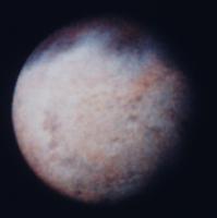
Here are some of my favs... global views
http://astrogeology.usgs.gov/Projects/Brow...ifs/triton2.gif http://nssdc.gsfc.nasa.gov/imgcat/hires/vg2_1138639.gif And best of all |
|
|
|
|
Mar 8 2006, 09:31 AM
Post
#4
|
|
 Member Group: Members Posts: 106 Joined: 26-September 05 Member No.: 508 |
QUOTE (Decepticon @ Mar 8 2006, 01:26 AM) Here are some of my favs... global views And best of all Thanks Decepticon 
|
|
|
|
|
Mar 8 2006, 11:11 PM
Post
#5
|
|||
 Member Group: Members Posts: 288 Joined: 28-September 05 From: Orion arm Member No.: 516 |
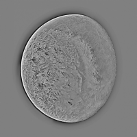
QUOTE (Decepticon @ Mar 8 2006, 12:26 AM) Here are some of my favs... global views http://astrogeology.usgs.gov/Projects/Brow...ifs/triton2.gif http://nssdc.gsfc.nasa.gov/imgcat/hires/vg2_1138639.gif And best of all Lovely... Beautiful...  But were has this orange hue gone?
The orange, turquoise and violet colors were the most astonishing and impressive features, when I first saw the images in 1989: 'Wow, so far away from sun and then these colors.' Actually images from less distance didn't show them in this color strenght any more... Why? False color imaging? What are the natural colors of Triton? Bye. |
||
|
|
|
||
|
Mar 9 2006, 02:41 AM
Post
#6
|
|
|
Interplanetary Dumpster Diver Group: Admin Posts: 4404 Joined: 17-February 04 From: Powell, TN Member No.: 33 |
Looks to me like like it is a color balance issue. And, remember that since it is Voyager data, there is no red, so the color will be shifted with either Green or Orange substituted for red.
-------------------- |
|
|
|
|
Jan 10 2010, 05:32 PM
Post
#7
|
|
 Member Group: Members Posts: 796 Joined: 27-February 08 From: Heart of Europe Member No.: 4057 |
Result from cooperation with Ted Stryk. Triton animation from four Ted Stryk's processed images (from Voyager 2 WAC camera). Framerate is one frame per 2 seconds. Images are magnified 2x. Time from 1989-08-25T08:15:09.000 to 1989-08-25T08:39:09.000.
Download link is lower. Old animation with wrong colors was deleted. -------------------- |
|
|
|
|
Jan 10 2010, 08:59 PM
Post
#8
|
|||
|
Junior Member Group: Members Posts: 52 Joined: 16-November 06 Member No.: 1364 |
Two Triton color composites:
|
||
|
|
|
||
|
Jan 11 2010, 11:02 AM
Post
#9
|
|
|
Member Group: Members Posts: 796 Joined: 27-February 08 From: Heart of Europe Member No.: 4057 |
Very nice images Stefan! Especially second one. One of the best Triton crescent images which I ever seen. But try remove color noise from image (speckles in image). Best way is perhaps manually removal. Than this image will be perfect.
I send improved version of Triton animation. Past version had wrong colors (problems with colorspace in encoder).
Attached File(s)
-------------------- |
|
|
|
|
Jan 11 2010, 03:49 PM
Post
#10
|
||
|
Junior Member Group: Members Posts: 52 Joined: 16-November 06 Member No.: 1364 |
Thanks, perhaps I'll find time to improve it.
Another color composite:
|
|
|
|
|
|
|
Jan 11 2010, 06:39 PM
Post
#11
|
|
|
Interplanetary Dumpster Diver Group: Admin Posts: 4404 Joined: 17-February 04 From: Powell, TN Member No.: 33 |
QUOTE (machi @ Jan 11 2010, 11:02 AM) I send improved version of Triton animation. Past version had wrong colors (problems with colorspace in encoder). Excellent work animating this! -------------------- |
|
|
|
|
Oct 16 2010, 01:30 AM
Post
#12
|
|||||
 Lord Of The Uranian Rings Group: Members Posts: 798 Joined: 18-July 05 From: Plymouth, UK Member No.: 437 |
I've often wondered which Voyager picture Candy Hansen used in the following video to demonstrate how tectonic activity may have altered Triton's surface:
http://www.youtube.com/watch?v=yy2iscggebI Well, I've found it -- it's a crop of image c1139623.png:
The cropped region:
In the video linked above, Ms. Hansen disects the image twice, moving the resultant pieces to reveal an ancient and degraded impact feature: Cut One:
Cut Two:
-------------------- |
||||
|
|
|
||||
|
Oct 16 2010, 04:35 PM
Post
#13
|
|
 Member Group: Members Posts: 207 Joined: 6-March 07 From: houston, texas Member No.: 1828 |
i had forgotten about this idea long ago. interesting but the difficulty has been that any number of cuts and rearrangements can be made on this surface and none are truly unique or diagnostic. this terrain is not easy to work on but it is comprised of lots of adjacent closed and partly open circular features of similar size, a characteristic of diapirism (think salt domes or convection) not impact craters.
-------------------- Dr. Paul Schenk, Lunar and Planetary Institute, Houston TX
http://stereomoons.blogspot.com; http://www.youtube.com/galsat400; http://www.lpi.usra.edu/science/schenk/ |
|
|
|
|
Oct 16 2010, 04:55 PM
Post
#14
|
|
|
Solar System Cartographer Group: Members Posts: 10162 Joined: 5-April 05 From: Canada Member No.: 227 |
I agree. It was an interesting idea, but different cuts and moves might create different apparent craters.
Phil -------------------- ... because the Solar System ain't gonna map itself.
Also to be found posting similar content on https://mastodon.social/@PhilStooke Maps for download (free PD: https://upload.wikimedia.org/wikipedia/comm...Cartography.pdf NOTE: everything created by me which I post on UMSF is considered to be in the public domain (NOT CC, public domain) |
|
|
|
|
Oct 19 2010, 04:16 PM
Post
#15
|
|||
|
Interplanetary Dumpster Diver Group: Admin Posts: 4404 Joined: 17-February 04 From: Powell, TN Member No.: 33 |
I played around with it when I was working on the images for this post and noticed the fact that multiple alignments seemed to work. http://planetimages.blogspot.com/2009/08/m...ton-images.html
By the way, here is my version of the last set before Triton filled the frame:
And the high-pass version:
-------------------- |
||
|
|
|
||
|
May 27 2011, 05:16 PM
Post
#16
|
||
|
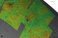
Member Group: Members Posts: 796 Joined: 27-February 08 From: Heart of Europe Member No.: 4057 |
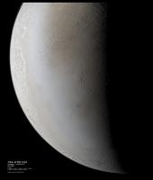
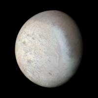
A long time ago, nearby a planet far far away ...
Triton hi-res mosaic from Voyager 2 spacecraft. Color is from wide angle camera images (color from violet, green and synthetic image). True resolution of images is between 0.7 to 1.05 km/pix (BW images) and 3.5 km/pix for color images. One version is with backround WAC image and other is without it and rotated by 90 degrees (so south is approx. down).
Attached thumbnail(s)
-------------------- |
|
|
|
|
|
|
May 27 2011, 05:18 PM
Post
#17
|
||
|
Member Group: Members Posts: 796 Joined: 27-February 08 From: Heart of Europe Member No.: 4057 |
Second image:
Attached thumbnail(s)
-------------------- |
|
|
|
|
|
|
May 27 2011, 05:47 PM
Post
#18
|
|
 Administrator Group: Admin Posts: 5172 Joined: 4-August 05 From: Pasadena, CA, USA, Earth Member No.: 454 |
Those are beautiful as usual, machi. Do you see any correlation between color and morphology?
-------------------- My website - My Patreon - @elakdawalla on Twitter - Please support unmannedspaceflight.com by donating here.
|
|
|
|
|
May 27 2011, 06:19 PM
Post
#19
|
|
|
Member Group: Members Posts: 796 Joined: 27-February 08 From: Heart of Europe Member No.: 4057 |
Rather not. It looks that most of color differences are caused by deposits from atmosphere (brown-orange are methane ices? and bright blueish are nitrogen ices).
During processing, I found only one darker spot in rough terrain (cantaloupe? terrain), which can be directly matched with some type of morphologic unit. Then bright ice deposits line the border of south polar ice cap and southern terrain is full of curvy units, which are more brownish (so presumably they contain more methane ices, geysers occurs in these regio). This terrain have not significant topography. But more interesting terrain is near terminator. I see terrain which looks like hybrid between Martian and Europaean terrain. Some regions looks like chaos terrain on Mars, some even with glimpse of outflow. -------------------- |
|
|
|
|
May 27 2011, 07:47 PM
Post
#20
|
|
 Senior Member Group: Members Posts: 3648 Joined: 1-October 05 From: Croatia Member No.: 523 |
Awesome work, these are keepers. Love the colors, too.
-------------------- |
|
|
|
|
May 27 2011, 09:31 PM
Post
#21
|
|
 Member Group: Members Posts: 700 Joined: 3-December 04 From: Boulder, Colorado, USA Member No.: 117 |
I also love the colors- they ring truer, somehow, than other versions that I've seen. I also love the almost seamless blending of the NAC and WAC images. Nice job!
John |
|
|
|
|
May 28 2011, 02:30 AM
Post
#22
|
|
|
Interplanetary Dumpster Diver Group: Admin Posts: 4404 Joined: 17-February 04 From: Powell, TN Member No.: 33 |
Spectacular! Wow, I never thought of merging the WA images with the earlier high-res images. I just used it to place the highest resolution shots. http://planetimages.blogspot.com/2009/08/m...ton-images.html I reprojected them into earlier images http://planetimages.blogspot.com/2009/08/s...rs-since-i.html
I am in awe. -------------------- |
|
|
|
|
May 28 2011, 02:35 AM
Post
#23
|
|
|
Member Group: Members Posts: 207 Joined: 6-March 07 From: houston, texas Member No.: 1828 |
i still wonder what the rest of Triton looks like . . .
-------------------- Dr. Paul Schenk, Lunar and Planetary Institute, Houston TX
http://stereomoons.blogspot.com; http://www.youtube.com/galsat400; http://www.lpi.usra.edu/science/schenk/ |
|
|
|
|
Feb 19 2012, 05:49 PM
Post
#24
|
||
 Senior Member Group: Members Posts: 1637 Joined: 5-March 05 From: Boulder, CO Member No.: 184 |
Greetings,
Thought I'd post here an updated version of the feature overlays on my Triton map. I'll have to consider adjusting the color based on the above images.
Steve -------------------- Steve [ my home page and planetary maps page ]
|
|
|
|
|
|
|
Feb 1 2014, 07:10 PM
Post
#25
|
|
|
Junior Member Group: Members Posts: 52 Joined: 16-November 06 Member No.: 1364 |
|
|
|
|
|
Feb 2 2014, 12:57 AM
Post
#26
|
|
|
Member Group: Members Posts: 890 Joined: 18-November 08 Member No.: 4489 |
that is voy2 PDS image "c1140138.imq"
http://pds-imaging.jpl.nasa.gov/data/voyager/vg_0011/triton/ http://pds-imaging.jpl.nasa.gov/data/voyag...xx/c1140138.imq |
|
|
|
|
Feb 2 2014, 01:37 PM
Post
#27
|
|||
|
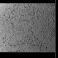
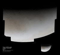
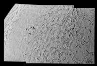
Junior Member Group: Members Posts: 52 Joined: 16-November 06 Member No.: 1364 |
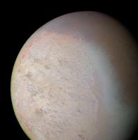
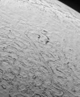
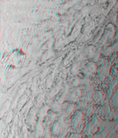
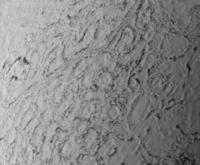
I am always fascinated by this image (C1139627), because it shows the surface of Triton as if you would see it from an airplane window. So far, I've only seen it stretched (for example here). Here it is with the full dynamic range, so you can see the atmosphere and details in the dark terrain. I've also made a stereo image.
|
||
|
|
|
||
|
Feb 2 2014, 02:53 PM
Post
#28
|
|
|
Member Group: Members Posts: 700 Joined: 3-December 04 From: Boulder, Colorado, USA Member No.: 117 |
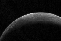
Yes, it's a beauty! It's also rather poignant, because it's the last high-resolution, close-up, image taken in the entire Voyager mission. After that, all we had were ever-diminishing crescent views of Triton and Neptune.
John |
|
|
|
|
Feb 2 2014, 04:28 PM
Post
#29
|
|
|
Member Group: Members Posts: 241 Joined: 16-May 06 From: Geneva, Switzerland Member No.: 773 |
I agree ! This is my favourite image of the Voyager 2 Neptune encounter. Flying over this frigid ice landscape... a dream ! It inspired me a lot to write my novels. It's a pity that we will not get again such images of Triton for a while. But I expect something similar with New Horizons about Pluto/Charon very soon...
Marc. |
|
|
|
|
Feb 2 2014, 07:39 PM
Post
#30
|
|
|
Solar System Cartographer Group: Members Posts: 10162 Joined: 5-April 05 From: Canada Member No.: 227 |
You might like to look back at this thread as well.
Phil http://www.unmannedspaceflight.com/index.p...mp;#entry138447 -------------------- ... because the Solar System ain't gonna map itself.
Also to be found posting similar content on https://mastodon.social/@PhilStooke Maps for download (free PD: https://upload.wikimedia.org/wikipedia/comm...Cartography.pdf NOTE: everything created by me which I post on UMSF is considered to be in the public domain (NOT CC, public domain) |
|
|
|
|
Feb 3 2014, 10:31 AM
Post
#31
|
|
|
Member Group: Members Posts: 102 Joined: 8-August 12 Member No.: 6511 |
We're not seeing any better images of Triton for at least 20 years, right? No currently planned missions to Neptune by anyone, and (if my BOTE calculation is correct) even the Watt won't be able to approach Voyager's levels of resolution.
Truly, this outer planets work is a game for the patient. Doug M. |
|
|
|
|
Feb 3 2014, 10:38 AM
Post
#32
|
|
|
Interplanetary Dumpster Diver Group: Admin Posts: 4404 Joined: 17-February 04 From: Powell, TN Member No.: 33 |
What is the WATT?
-------------------- |
|
|
|
|
Feb 3 2014, 01:41 PM
Post
#33
|
|
 Senior Member Group: Members Posts: 2173 Joined: 28-December 04 From: Florida, USA Member No.: 132 |
QUOTE (tedstryk @ Feb 3 2014, 05:38 AM) What is the WATT? James Watt space telescope? |
|
|
|
|
Feb 3 2014, 01:45 PM
Post
#34
|
|
|
Member Group: Members Posts: 241 Joined: 16-May 06 From: Geneva, Switzerland Member No.: 773 |
Do you mean James Webb space telescope ?
|
|
|
|
|
Feb 3 2014, 02:09 PM
Post
#35
|
|
|
Senior Member Group: Members Posts: 2173 Joined: 28-December 04 From: Florida, USA Member No.: 132 |
Woops! Don't worry mister Watt, some day they'll name something after you.

|
|
|
|
|
Feb 3 2014, 04:24 PM
Post
#36
|
|
|
Interplanetary Dumpster Diver Group: Admin Posts: 4404 Joined: 17-February 04 From: Powell, TN Member No.: 33 |
The JWST is an infrared telescope. It won't have the spatial resolution to even match Hubble.
-------------------- |
|
|
|
|
Feb 3 2014, 07:05 PM
Post
#37
|
|
|
Member Group: Members Posts: 890 Joined: 18-November 08 Member No.: 4489 |
so basically
it is reprocessing the old data with NEW software on new machines that have more than a 8086 and 32 meg ram voy2isis, voycal, isis2raw( 32bit raw), adjust min/max and gama ( 0.6) , inpaint missing data ( "resynthesizer" )  gmic pde ( wavelet ) to smooth the noise 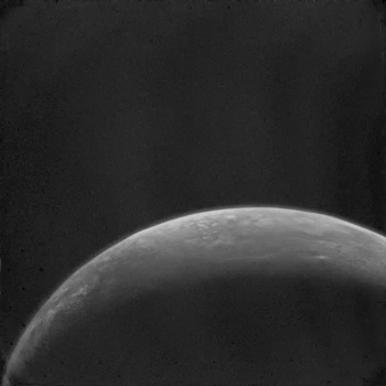 the straight imq to png , then the orig AFTER adjust min/max and gama  
|
|
|
|
|
Feb 4 2014, 01:40 AM
Post
#38
|
|
|
Member Group: Members Posts: 124 Joined: 20-April 05 Member No.: 291 |
Hmmm... in the post Hubble era, will any scope be able to do high resolution observation of outer solar system objects with comparable or better resolution? Perhaps the Thity Meter Telescope or one of the other monsters being built on the ground? Or one of the donated NRO scopes?
|
|
|
|
|
Feb 4 2014, 01:44 AM
Post
#39
|
|
|
Founder Group: Chairman Posts: 14432 Joined: 8-February 04 Member No.: 1 |
Pre or post Hubble....physics is physics.....the laws of optics still apply. The short answer is no. The long answer is in the physics described here : http://www.telescope-optics.net/telescope_resolution.htm
|
|
|
|
|
Feb 4 2014, 01:48 AM
Post
#40
|
|
|
Member Group: Members Posts: 124 Joined: 20-April 05 Member No.: 291 |
Sorry - wasn't clear. I wasn't asking if we could get Voyager level resolution, I already understood that was impossible - I was wondering what telescopes now or in planning for the next 10 years had _Hubble_ comparable resolution for outer-system objects.
|
|
|
|
|
Feb 4 2014, 02:42 AM
Post
#41
|
|
|
Member Group: Members Posts: 890 Joined: 18-November 08 Member No.: 4489 |
a BUNCH of new spacecraft will need to be sent out to the outer solar system
one for each planet and some for just the major moons [ADMIN EDIT] |
|
|
|
|
Feb 4 2014, 04:26 AM
Post
#42
|
|
|
Solar System Cartographer Group: Members Posts: 10162 Joined: 5-April 05 From: Canada Member No.: 227 |
Telescopes on the ground as good as Hubble - you bet. The advantage of Hubble being above the atmosphere has to a great degree been overcome with larger optics and adaptive optics on the ground. Look in this thread:
http://www.unmannedspaceflight.com/index.p...mp;#entry193614 for examples of Uranus from Keck. Hubble can still compete in wavelengths that don't reach the ground. Phil (PS now I want to see Keck image Ceres!) -------------------- ... because the Solar System ain't gonna map itself.
Also to be found posting similar content on https://mastodon.social/@PhilStooke Maps for download (free PD: https://upload.wikimedia.org/wikipedia/comm...Cartography.pdf NOTE: everything created by me which I post on UMSF is considered to be in the public domain (NOT CC, public domain) |
|
|
|
|
Feb 4 2014, 09:00 AM
Post
#43
|
|
|
Member Group: Members Posts: 102 Joined: 8-August 12 Member No.: 6511 |
Daaah, the Webb not the Watt. Excuse me.
A new generation of ground-based Extremely Large Telescopes will come online in the next decade. Both the Thirty Meter Telescope (Hawaii) and the European Extremely Large Telescope (Chile) are currently scheduled for first light in 2022. That's almost certainly optimistic -- but Magellan (Chile) is currently on schedule for first light in 2020. Ten years from now we should have two and maybe three ready to go. And all three of these things have apertures measured in tens of meters and surfaces measured in hundreds of square meters. (And price tags measured in eight or nine figures.) How well they'd image a moon of Neptune is beyond my limited physics, though. Anyone? Doug M. |
|
|
|
|
Feb 4 2014, 09:04 AM
Post
#44
|
||
|
Junior Member Group: Members Posts: 52 Joined: 16-November 06 Member No.: 1364 |
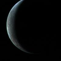
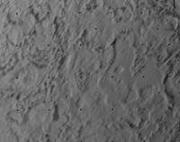
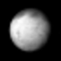
QUOTE (john_s @ Feb 2 2014, 03:53 PM) Yes, it's a beauty! It's also rather poignant, because it's the last high-resolution, close-up, image taken in the entire Voyager mission. After that, all we had were ever-diminishing crescent views of Triton and Neptune. Actually, there was one more! This one:
I used it as the "right eye" in my anaglyph. It is not as exciting as the other one, and also more blurry. |
|
|
|
|
|
|
Feb 4 2014, 07:04 PM
Post
#45
|
||
|
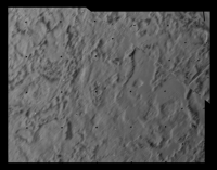
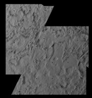
Interplanetary Dumpster Diver Group: Admin Posts: 4404 Joined: 17-February 04 From: Powell, TN Member No.: 33 |
This shows how the images fit together.
Attached thumbnail(s)
-------------------- |
|
|
|
|
|
|
Feb 4 2014, 07:31 PM
Post
#46
|
|
|
Member Group: Members Posts: 102 Joined: 8-August 12 Member No.: 6511 |
Gorgeous. Makes you wonder if Pluto will have similar "cantelope" terrain? Some other sort of geologically active surface? Or just ancient craters on ice?
Whatever is there, we should (eventually, weeks and months after flyby) get good pictures of it -- NASA says that New Horizons will give us "images with resolution as high as 25 m/pixel, 4-color global dayside maps at 0.7 km/pixel, hyper-spectral near infrared maps at 7 km/pixel globally and 0.6 km/pixel for selected areas". The late Argo proposal for a mission to Neptune -- a flyby with a subsequent visit to a Kuiper Belt Object -- would have been basically New Horizon with a somewhat different instrument suite and 2010s technology. It would have flown as close as 200 km (!) to Triton, which would have allowed resolutions down in the tens-of-meters range. Argo depended on a Jupiter-Saturn flyby, though -- a planetary alignment that will go away for a long time in 2020. So, probably not. Doug M. |
|
|
|
|
Feb 4 2014, 09:55 PM
Post
#47
|
|
|
Member Group: Members Posts: 700 Joined: 3-December 04 From: Boulder, Colorado, USA Member No.: 117 |
Couple comments:
1) I thought the crisp horizon shot of the canteloupe terrain was taken after that blurrier overlapping image, but maybe I'm mis-remembering. I guess I'm biased in favor of the horizon shot, because it's sharper, but also because I wrote the original press release caption for it, back in 1989  . .2) I'm not sure where the 25 m/pixel number came from for the best New Horizons resolution on Pluto- the best resolution will actually be about 90 meters/pixel (much better than that best Voyager Triton image). John |
|
|
|
|
Feb 5 2014, 08:58 AM
Post
#48
|
|
|
Member Group: Members Posts: 102 Joined: 8-August 12 Member No.: 6511 |
QUOTE (john_s @ Feb 4 2014, 11:55 PM) 2) I'm not sure where the 25 m/pixel number came from for the best New Horizons resolution on Pluto- the best resolution will actually be about 90 meters/pixel (much better than that best Voyager Triton image). John, that figure comes from this NASA page. The quote is from the 'Mission Profile' section: "Flyby of Pluto will occur nominally on 14 July 2015. The encounter period begins 6 months prior to closest approach. Long range imaging will include 40 km mapping of Pluto and Charon 3.2 days out. This is half the rotation period of Pluto-Charon and will allow imaging of the side of both bodies which will be facing away from the spacecraft at closest approach. New Horizons will fly within 10000 km of Pluto at a relative velocity of 11 km/s at closest approach and will come as close as 27,000 km to Charon. During the flyby the instruments should be able to obtain images with resolution as high as 25 m/pixel, 4-color global dayside maps at 0.7 km/pixel, hyper-spectral near infrared maps at 7 km/pixel globally and 0.6 km/pixel for selected areas, characterization of the atmosphere, and radio science results. Because of the limited power available, the instruments will be duty cycled during encounter." Doug M. |
|
|
|
|
Feb 5 2014, 10:59 AM
Post
#49
|
|
|
Junior Member Group: Members Posts: 52 Joined: 16-November 06 Member No.: 1364 |
QUOTE (john_s @ Feb 4 2014, 10:55 PM) 1) I thought the crisp horizon shot of the canteloupe terrain was taken after that blurrier overlapping image, but maybe I'm mis-remembering. I guess I'm biased in favor of the horizon shot, because it's sharper, but also because I wrote the original press release caption for it, back in 1989 .That's fascinating, John, you must have been so excited at the time! Do you remember what you wrote? |
|
|
|
|
Feb 5 2014, 11:43 AM
Post
#50
|
|
|
Interplanetary Dumpster Diver Group: Admin Posts: 4404 Joined: 17-February 04 From: Powell, TN Member No.: 33 |
John, is this the original caption? I'm assuming it is referring to true resolution, as the resolution in km/pixel is better than that.
-------------------- |
|
|
|
|
Feb 5 2014, 08:51 PM
Post
#51
|
|
|
Member Group: Members Posts: 700 Joined: 3-December 04 From: Boulder, Colorado, USA Member No.: 117 |
Yes, and yes. I was a post-doc at the time, working with imaging team member Dave Morrison. I felt very lucky to be there- and even luckier to have also been at the Saturn and Uranus flybys, as a grad student.
That NSSDC quote is just plain wrong- the math doesn't work, given the resolution of the LORRI camera (5 microradians) and the stated encounter distance (10,000 km). Probably not worth fixing at this point, though John |
|
|
|
|
Feb 6 2014, 12:15 AM
Post
#52
|
|||
|
Member Group: Members Posts: 796 Joined: 27-February 08 From: Heart of Europe Member No.: 4057 |
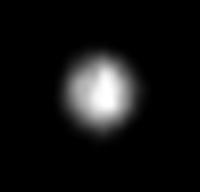
QUOTE (dtolman @ Feb 4 2014, 02:48 AM) Sorry - wasn't clear. I wasn't asking if we could get Voyager level resolution, I already understood that was impossible - I was wondering what telescopes now or in planning for the next 10 years had _Hubble_ comparable resolution for outer-system objects. As Phil already said, some telescopes are already better than HST in infrared. For now best images are from Keck II and Gemini. Keck II is even comparable in absolute terms to HST, if atmospheric conditions are good. Best resolution is then around 0.03 arcsec. This is equivalent to 4 resolution elements across Triton disc or ~650 km at Neptune distance. HST has same resolution in wavelength near UV/visible border. New instrument - GPI on Gemini has similar resolution. In near future (this year?) SPHERE will be available on VLT (ESO) with peak resolution around 0.02 arcsec (6 elements across Triton's disc). QUOTE (Doug M. @ Feb 4 2014, 10:00 AM) Daaah, the Webb not the Watt. Excuse me. A new generation of ground-based Extremely Large Telescopes will come online in the next decade. Both the Thirty Meter Telescope (Hawaii) and the European Extremely Large Telescope (Chile) are currently scheduled for first light in 2022. ... How well they'd image a moon of Neptune is beyond my limited physics, though. Anyone? Doug M. TMT has planned resolution better than 0.01 arcsec with IRIS camera (0.008?). This is better than 200 km at Neptune and ~10-15 resolution elements for Triton disc at best. E-ELT will be even better. It's exoplanetary imager EPICS has planned resolution up to 5 miliarcsec. With this resolution numbers are 110 km and 25 resolution elements for Triton. But those are results for optimal conditions. Ground telescopes are dependent on good atmospheric conditions and powerful systems of adaptive optics. And adaptive optics needs for optimal operation bright point sources of light. Bright stars are best for this but such stars are available only for small areas of sky. Modern telescopes with adaptive optics are equipped with lasers which can produce artificial stars in atmosphere. With this lasers, telescopes are not so limited in their choice of targets on the sky, but results are always worse than in case with bright natural star. This is example how Triton might look from E-ELT EPICS under optimal conditions and how it looks now from HST (FOC camera) (both images are magnified):
Attached thumbnail(s)
-------------------- |
||
|
|
|
||
|
Feb 6 2014, 09:20 PM
Post
#53
|
|
|
Member Group: Members Posts: 241 Joined: 16-May 06 From: Geneva, Switzerland Member No.: 773 |
Even if there will be no mission to Neptune and Triton for a while, I think there might be still some discoveries to be made by using new image processing techniques of old Voyager pictures. I'm convinced that these images still hide some secrets. And we have some very talented people here. So keep going on processing them !
Best regards. Marc. |
|
|
|
|
Aug 22 2014, 02:23 PM
Post
#54
|
|
 Member Group: Members Posts: 495 Joined: 12-February 12 Member No.: 6336 |
I have always thought Triton to be among the very most interesting moons. So all happy to find this new Triton map presented.
|
|
|
|
|
Aug 22 2014, 06:18 PM
Post
#55
|
|
|
Senior Member Group: Members Posts: 1637 Joined: 5-March 05 From: Boulder, CO Member No.: 184 |
Yes, nice details can be seen on this map (from Dr. Shank). I wonder if the greenish cast in some areas would actually look that way to the human eye?
-------------------- Steve [ my home page and planetary maps page ]
|
|
|
|
|
Aug 22 2014, 07:27 PM
Post
#56
|
|
|
Member Group: Members Posts: 241 Joined: 16-May 06 From: Geneva, Switzerland Member No.: 773 |
Paul Schenk is a magician to turn old pictures in new ones. I really dream about an Atlas of the Ice Giants Moons (Uranus and Neptune) like the Atlas of the Galilean satellites. Of course, there is not as much stuff as for the Galilean satellites and only their southern hemispheres have benn covered, but probably enough to do something great with processed Voyager 2 pictures.
Regards Marc. |
|
|
|
|
Aug 22 2014, 09:48 PM
Post
#57
|
|
|
Member Group: Members Posts: 495 Joined: 12-February 12 Member No.: 6336 |
QUOTE (scalbers @ Aug 22 2014, 08:18 PM) Yes, nice details can be seen on this map (from Dr. Shank). I wonder if the greenish cast in some areas would actually look that way to the human eye? I feel quite certain the colours of that map are enhanced, but it is ok since it help us see details - just like the crisscrossing bands of Europa would be hard to see without such processing. I expect that Triton would appear rather grey to the human eye, and that not just because of the fainter light at that distance from the Sun. |
|
|
|
|
Aug 23 2014, 04:19 PM
Post
#58
|
||
|
Senior Member Group: Members Posts: 3648 Joined: 1-October 05 From: Croatia Member No.: 523 |
QUOTE (scalbers @ Aug 22 2014, 08:18 PM) I wonder if the greenish cast in some areas would actually look that way to the human eye? In my experience, calibration with Voyagers is an issue. Compared to Galileo and Cassini images of Jupiter and Saturn targets, it seems to me the relative filter brightnesses are off for all cameras. Green channel typically ends up being too bright compared to other filters which, along with the O/G/B filter combination, can lead to greenish results. A while back I attempted to use Saturn targets like Mimas, Enceladus, Dione and Iapetus to figure out better correction factors, with mixed results. Here's how a quick-n-dirty Triton O/G/B image turned out using those factors and also corrected for OGB -> sRGB filter wavelengths using linear interpolation:
Source images: C1138639, C1138651, C1138703 -------------------- |
|
|
|
|
|
|
Aug 23 2014, 08:05 PM
Post
#59
|
||
|
Interplanetary Dumpster Diver Group: Admin Posts: 4404 Joined: 17-February 04 From: Powell, TN Member No.: 33 |
This was my result with that dataset. I will say that not only is Voyager calibration an issue, but there was an entropy issue that seemed to get worse throughout the mission which made compensating for different exposure lengths difficult.
-------------------- |
|
|
|
|
|
|
Aug 23 2014, 09:26 PM
Post
#60
|
|
|
Member Group: Members Posts: 207 Joined: 6-March 07 From: houston, texas Member No.: 1828 |
hi guys,
thanks for the nice words. more new maps in a few weeks! i also have the Triton high-res mosaic, which is almost done. Ive updated the blog but wanted to point out that the map format is perfect for dropping into google earth or similar thing. also the contrast is stretch a little bit but the color is not differentially enhanced. the contrast stretch brings out some of the color differences a little bit more. can't wait to put the pluto map next to it next year. p -------------------- Dr. Paul Schenk, Lunar and Planetary Institute, Houston TX
http://stereomoons.blogspot.com; http://www.youtube.com/galsat400; http://www.lpi.usra.edu/science/schenk/ |
|
|
|
|
Aug 23 2014, 09:34 PM
Post
#61
|
||
|
Member Group: Members Posts: 207 Joined: 6-March 07 From: houston, texas Member No.: 1828 |
QUOTE (ugordan @ Aug 23 2014, 11:19 AM) In my experience, calibration with Voyagers is an issue. Compared to Galileo and Cassini images of Jupiter and Saturn targets, it seems to me the relative filter brightnesses are off for all cameras. Green channel typically ends up being too bright compared to other filters which, along with the O/G/B filter combination, can lead to greenish results. A while back I attempted to use Saturn targets like Mimas, Enceladus, Dione and Iapetus to figure out better correction factors, with mixed results. Here's how a quick-n-dirty Triton O/G/B image turned out using those factors and also corrected for OGB -> sRGB filter wavelengths using linear interpolation:
Source images: C1138639, C1138651, C1138703 that is interesting to hear. I wondered about that but we have no other reliable color data for Triton for comparison. perhaps you can send me some of your estimates for how far off the colors might be. in the meantime, i can look at some saturn data. a difficulty s that the cassini and voyager filters are not identical. -------------------- Dr. Paul Schenk, Lunar and Planetary Institute, Houston TX
http://stereomoons.blogspot.com; http://www.youtube.com/galsat400; http://www.lpi.usra.edu/science/schenk/ |
|
|
|
|
|
|
Aug 24 2014, 05:03 PM
Post
#62
|
|
 IMG to PNG GOD Group: Moderator Posts: 2250 Joined: 19-February 04 From: Near fire and ice Member No.: 38 |
I have the same experience as Ted and Gordan, I always need to use various correction/fudge factors to get correct color when doing color composites from the Voyager images. As Gordan mentioned, the green channel is usually too bright. I usually use the calibrated and geometrically corrected images available at the PDS Planetary Rings Node but I get similar results if I start with the raw (*.IMQ) images and calibrate them myself.
I haven't done any systematic analysis to see if this problem varies as a function of time, exposure, gain etc. but I suspect that at least time (or mission phase) is significant. For many targets I can use the global spectrum to check the color but this is especially difficult for Triton since its color varies with time. For Neptune I can use its spectrum plus HST images to check the color and determine the correction factors - using the same processing parameters for Triton might work to get correct color. |
|
|
|
|
Aug 25 2014, 12:17 PM
Post
#63
|
|
|
Member Group: Members Posts: 495 Joined: 12-February 12 Member No.: 6336 |
QUOTE (DrShank @ Aug 23 2014, 11:26 PM) ....can't wait to put the pluto map next to it next year. Oh hello there Dr Shank. =) Yes I really would like to see a comparison between those two also to see if they show any signs of having a common origin. I always have considered Triton to have been captured by Neptune even when the ejection hypothesis were the more popular one. A little bit OT for this thread yet some expect Charon to show an interesting surface as well I am a bit pessimistic about that idea, but then again our own moon have recently been found to have a molten core even found today despite the fact it got bound rotation so it might be best never to say never to tidal heating. =) |
|
|
|
|
Aug 26 2014, 01:54 PM
Post
#64
|
|
|
Solar System Cartographer Group: Members Posts: 10162 Joined: 5-April 05 From: Canada Member No.: 227 |
Fantastic new map of Triton, Paul, thanks! It is nice to see the post-encounter crescent images incorporated into it.
Phil -------------------- ... because the Solar System ain't gonna map itself.
Also to be found posting similar content on https://mastodon.social/@PhilStooke Maps for download (free PD: https://upload.wikimedia.org/wikipedia/comm...Cartography.pdf NOTE: everything created by me which I post on UMSF is considered to be in the public domain (NOT CC, public domain) |
|
|
|
|
Aug 29 2014, 02:54 PM
Post
#65
|
|
|
Junior Member Group: Members Posts: 64 Joined: 17-December 12 From: Portugal Member No.: 6792 |
QUOTE (Bjorn Jonsson @ Aug 24 2014, 05:03 PM) I haven't done any systematic analysis to see if this problem varies as a function of time, exposure, gain etc. but I suspect that at least time (or mission phase) is significant. Back at the time I was playing with Voyager images I also noticed that. My guess is that the filter's response changed with time. So it's dependent on mission time, craft and camera. If there are any images of stars taken during the mission (I guess so) perhaps they can be used to infer calibration. "White" satellites (if we have some spectra for them) would also work on distant images that show more than one (for different brightness), so that you could linearize the filters response. Just my 2 cents... -------------------- www.astrosurf.com/nunes
|
|
|
|
|
Aug 1 2018, 09:59 AM
Post
#66
|
|
|
Member Group: Members Posts: 241 Joined: 16-May 06 From: Geneva, Switzerland Member No.: 773 |
Finally a "serious" geological map of Triton:
Triton map "To-date, no peer-reviewed, broad-scale, detailed geologic map exists to characterize, classify, and identify geologic surface units and features on Triton. Mapping of Pluto and Charon is in progress, but as no comparable geologic map of Triton exists, a direct comparison between these two KBOs cannot be performed at a fundamental level. Furthermore, as Triton serves as a bridge between KBOs and icy satellites, characterization of its terrains is important for advancing comparative planetological studies." Can't wait to see the final result. I expect some interesting discoveries, almost 30 years after the voyager II flyby. Best regards, Marc. |
|
|
|
|
Aug 6 2018, 05:14 PM
Post
#67
|
|
|
Member Group: Members Posts: 241 Joined: 16-May 06 From: Geneva, Switzerland Member No.: 773 |
2018 paper with Voyager II Triton images:
Planetary and Space Science Volume 160, 1 October 2018, Pages 19-25 Heat flow in Triton: Implications for heat sources powering recent geologic activity Alvaro Martin-Herrero, Ignacio Romeo, JavierRuiz New analysis of Voyager images reveals that the Raz fossae troughs system continues north of Leviathan patera and Cipango planum and enables to calculate that the surface heat flows values are much higher than those estimated in previous studies. This troughs system reminds me the North-South global ridge/troughs sytem recently discovered on Pluto. I'm convinced that some new great discoderies can be made by reprocessing the almost 30 years old Voyager images, even if a new mission to the Neptunian system is absolutely necessary. Regards, Marc. |
|
|
|
|
Sep 2 2021, 02:12 AM
Post
#68
|
|
|
Merciless Robot Group: Admin Posts: 8784 Joined: 8-December 05 From: Los Angeles Member No.: 602 |
Resurrecting a dormant thread, there's a new paper out concerning Triton's topography. Prime author is Paul Schenk, coauthors include frequent Forum participant & NH PI Alan Stern and Forum moderator Ted Stryk, featuring Ted's image wizardry. Enjoy!
-------------------- A few will take this knowledge and use this power of a dream realized as a force for change, an impetus for further discovery to make less ancient dreams real.
|
|
|
|
|
Sep 2 2021, 07:28 AM
Post
#69
|
|
|
Senior Member Group: Members Posts: 2920 Joined: 14-February 06 From: Very close to the Pyrénées Mountains (France) Member No.: 682 |
As a personal story, I was with TPS for Planetfest 89 at the time of Neptune flyby. We waited late to see the very first Tritons pictures. When they came, around 4 am, I was already back in my hotel and discovered them on TV when I woke up. At that time, I was allowed to enter JPLs reception and check TV screens and get a feeling of the place. We had scientist, no less than Ed Stone himself, giving the last news and picture at the TPS event.
Youre not only resurrecting a thread Nick, but also good memories. At that time, we hopped VII would survive for another 35 years, were close to it. Both Voyagers were launched the year I started working and I retired 5 years ago. -------------------- |
|
|
|
|
Sep 19 2021, 06:29 PM
Post
#70
|
|
 Member Group: Members Posts: 127 Joined: 15-April 21 Member No.: 9009 |
QUOTE (nprev @ Sep 2 2021, 03:12 AM) Resurrecting a dormant thread, there's a new paper out concerning Triton's topography. Prime author is Paul Schenk, coauthors include frequent Forum participant & NH PI Alan Stern and Forum moderator Ted Stryk, featuring Ted's image wizardry. Enjoy! SWEEET! i think i can compile a DEM map out of some of the higher res figures |
|
|
|
|
Sep 19 2021, 07:43 PM
Post
#71
|
||
|
Member Group: Members Posts: 127 Joined: 15-April 21 Member No.: 9009 |
i compiled most of the stuff into the below
|
|
|
|
|
|
|
Nov 7 2021, 02:49 PM
Post
#72
|
|
|
Member Group: Members Posts: 127 Joined: 15-April 21 Member No.: 9009 |
QUOTE (machi @ May 27 2011, 06:18 PM) Second image: i increased brightness (messing with curves) , looking for neptuneshine, and i found this stuff beyond the terminator, is it atmospheric haze lit terrain , neptuneshine, or plain old noise?  i also seen it in the other pic too when i messed with curves 
|
|
|
|
|
Nov 7 2021, 04:23 PM
Post
#73
|
|
|
Member Group: Members Posts: 910 Joined: 4-September 06 From: Boston Member No.: 1102 |
It is not clear to me what what areas you refer to as recovered in your posts. Maybe you could post three image, the original image unmodified, your clean modified image, and the area of interest (ie newly recovered area) circled or specifically delineated. The cloud of dots past the teminator in the image above seem to me to be noise, but maybe that is not the area you are describing.
-------------------- |
|
|
|
|
Nov 7 2021, 04:46 PM
Post
#74
|
|
 Senior Member Group: Members Posts: 2530 Joined: 20-April 05 Member No.: 321 |
By no means is doing this with images that someone has already processed for another purpose the best way to proceed. Whatever artifacts they may have introduced at very low values (0, 1, 2) is part of what you're trying to make something of now. There are multiple obvious artifacts and there's no accounting therefore for what is artifact and what isn't.
Never with work like this should you begin with an image that someone posted after performing undocumented processing to the original. |
|
|
|
|
Nov 7 2021, 07:24 PM
Post
#75
|
|
|
Member Group: Members Posts: 127 Joined: 15-April 21 Member No.: 9009 |
QUOTE (Floyd @ Nov 7 2021, 04:23 PM) It is not clear to me what what areas you refer to as recovered in your posts. Maybe you could post three image, the original image unmodified, your clean modified image, and the area of interest (ie newly recovered area) circled or specifically delineated. The cloud of dots past the teminator in the image above seem to me to be noise, but maybe that is not the area you are describing. yeah, the cloud of dots beyond the teminator is what i am talking about, bummer its just noise |
|
|
|
|
Nov 7 2021, 07:30 PM
Post
#76
|
|
|
Member Group: Members Posts: 127 Joined: 15-April 21 Member No.: 9009 |
QUOTE (JRehling @ Nov 7 2021, 04:46 PM) By no means is doing this with images that someone has already processed for another purpose the best way to proceed. Whatever artifacts they may have introduced at very low values (0, 1, 2) is part of what you're trying to make something of now. There are multiple obvious artifacts and there's no accounting therefore for what is artifact and what isn't. Never with work like this should you begin with an image that someone posted after performing undocumented processing to the original. all the images on USGS PILOT are low resolution, and are full of jpeg artifacts, witch destroys any detail from potential neptuneshine or atmospheric haze lit terrain (same goes for PDS Image Atlas) so where can i go to get original unprocessed images that doesn't have jpeg artifacts and is a good resolution |
|
|
|
|
Nov 7 2021, 07:38 PM
Post
#77
|
|
|
Senior Member Group: Members Posts: 2517 Joined: 13-September 05 Member No.: 497 |
QUOTE (TrappistPlanets @ Nov 7 2021, 11:30 AM) so where can i go to get original unprocessed images that doesn't have jpeg artifacts and is a good resolution https://pds-imaging.jpl.nasa.gov/volumes/voyager.html has the raw images in PDS format. -------------------- Disclaimer: This post is based on public information only. Any opinions are my own.
|
|
|
|
|
Nov 7 2021, 07:48 PM
Post
#78
|
|
|
Senior Member Group: Members Posts: 2530 Joined: 20-April 05 Member No.: 321 |
QUOTE (TrappistPlanets @ Nov 7 2021, 12:30 PM) so where can i go to get original unprocessed images that doesn't have jpeg artifacts and is a good resolution This thread itself, if you go back to the beginning, is full of information useful to the topic at hand, including a link to: http://www.unmannedspaceflight.com/index.p...mp;#entry138447 which has more links to more information. In general, this board is incredibly informative if you focus on the text as well as the images. Photoshopping the images you find is never going to be as informative as reading and following up on all of the discussion, which has already spoken to some of your questions. If you find something interesting in the nth post of a thread, consider reading posts #1- (n-1) in that thread. |
|
|
|
|
Nov 7 2021, 10:51 PM
Post
#79
|
|
|
Member Group: Members Posts: 127 Joined: 15-April 21 Member No.: 9009 |
QUOTE (mcaplinger @ Nov 7 2021, 07:38 PM) https://pds-imaging.jpl.nasa.gov/volumes/voyager.html has the raw images in PDS format. where do i find the triton images though, and can gimp open that format, i use GIMP not PS |
|
|
|
|
Nov 7 2021, 11:12 PM
Post
#80
|
|
|
Founder Group: Chairman Posts: 14432 Joined: 8-February 04 Member No.: 1 |
QUOTE (TrappistPlanets @ Nov 7 2021, 03:51 PM) where do i find the triton images though, and can gimp open that format, i use GIMP not PS You are going to have to do some of this work yourself. Google is your friend. The PDS is thoroughly documented. There are many tools available to process the products it has. The PDS has search tools. http://bjj.mmedia.is/utils/img2png/ is what you will probably want to turn PDS published data into something GIMP can open. |
|
|
|
|
Nov 8 2021, 01:39 AM
Post
#81
|
|
|
Senior Member Group: Members Posts: 2517 Joined: 13-September 05 Member No.: 497 |
QUOTE (TrappistPlanets @ Nov 7 2021, 02:51 PM) where do i find the triton images though... Maybe in the triton subdirectories? The image names that when into the mosaics are shown at the bottom of the mosaics. Honestly you have this a lot easier than I did in 1981 when I saw my first Voyager data on 6250 bpi magnetic tapes. -------------------- Disclaimer: This post is based on public information only. Any opinions are my own.
|
|
|
|
|
Nov 8 2021, 02:24 AM
Post
#82
|
||
|
Member Group: Members Posts: 890 Joined: 18-November 08 Member No.: 4489 |
use PILOT
it is a search tool
you will need to open the *.imq files ( voyager are NOT the default img files ) then remove the reasue dots |
|
|
|
|
|
|
Nov 9 2021, 11:55 AM
Post
#83
|
||
|
Member Group: Members Posts: 127 Joined: 15-April 21 Member No.: 9009 |
QUOTE (JohnVV @ Nov 8 2021, 02:24 AM) use PILOT it is a search tool
you will need to open the *.imq files ( voyager are NOT the default img files ) then remove the reasue dots how do i open the imq files in gimp? |
|
|
|
|
|
|
Nov 9 2021, 02:40 PM
Post
#84
|
|
|
Member Group: Members Posts: 890 Joined: 18-November 08 Member No.: 4489 |
i think that " img2png" can open Voyager pds images
however i use ISIS4 on them |
|
|
|
|
Nov 9 2021, 09:51 PM
Post
#85
|
|
|
Member Group: Members Posts: 127 Joined: 15-April 21 Member No.: 9009 |
QUOTE (JohnVV @ Nov 9 2021, 03:40 PM) i think that " img2png" can open Voyager pds images however i use ISIS4 on them i am trying to find a 32 bit program of img2png, but i can't seem to find one, although google said "IMG2PNG is now a 64 bit program (earlier versions were 32 bit). This was a necessary change to make it possible to convert extremely large images, in particular 46080x23040 pixel LRO DEMs" where can i find the previous versions that are 32 bit so i can try the program on triton |
|
|
|
|
Nov 10 2021, 12:34 AM
Post
#86
|
|
|
Member Group: Members Posts: 408 Joined: 18-September 17 Member No.: 8250 |
QUOTE (TrappistPlanets @ Nov 9 2021, 01:51 PM) ... where can i find the previous versions that are 32 bit so i can try the program on triton You could take a look at the old version from the Internet Archive http://web.archive.org/web/20190430175504/.../utils/img2png/ |
|
|
|
|
Jun 20 2022, 01:20 PM
Post
#87
|
||
 Member Group: Members Posts: 349 Joined: 20-June 07 From: Slovenia Member No.: 2461 |
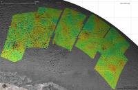
Recently data from the article by Schenk et al. 2021 became available here.
I played around with stereo DEM data to create this maps, one showing the whole extent, the other close up of Kibu Patera area with contours. There are a lot of (sublimation?) holes visible in the terrain, that were not so obvious in photo only renderings. I guess this elevation dataset is all that will be available for a very long time...
|
|
|
|
|
|
|
Jun 20 2022, 01:22 PM
Post
#88
|
||
|
Member Group: Members Posts: 349 Joined: 20-June 07 From: Slovenia Member No.: 2461 |
Kibu Patera close-up map. |
|
|
|
|
|
 |

|
Lo-Fi Version | Time is now: 17th May 2024 - 11:26 AM |
|
RULES AND GUIDELINES Please read the Forum Rules and Guidelines before posting. IMAGE COPYRIGHT |
OPINIONS AND MODERATION Opinions expressed on UnmannedSpaceflight.com are those of the individual posters and do not necessarily reflect the opinions of UnmannedSpaceflight.com or The Planetary Society. The all-volunteer UnmannedSpaceflight.com moderation team is wholly independent of The Planetary Society. The Planetary Society has no influence over decisions made by the UnmannedSpaceflight.com moderators. |
SUPPORT THE FORUM Unmannedspaceflight.com is funded by the Planetary Society. Please consider supporting our work and many other projects by donating to the Society or becoming a member. |
|