Crossing the Dunes at Murray Buttes, Sites 54-62, Sols 1353-1659, May 28 2016-Apr 6 2017 |

  |
Crossing the Dunes at Murray Buttes, Sites 54-62, Sols 1353-1659, May 28 2016-Apr 6 2017 |
 May 27 2016, 11:01 AM May 27 2016, 11:01 AM
Post
#1
|
||
 Senior Member  Group: Members Posts: 2431 Joined: 30-January 13 From: Penang, Malaysia. Member No.: 6853 |
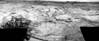
Midnight Planets has reported Curiosity's movement of ~46.3m WSW (-116º) on Sol 1353.
Only 7 L-NavCams were available for this rough & ready stitch in MS ICE, the raws are a little overexposed, but they may assist in pinpointing the location. I cropped the stitch a little to get it under the upload limit. I'll post the full resolution 360 on an image host as the images become available, unless someone beats me to it 
|
|
 |
 
|
|
|
May 28 2016, 03:49 AM
Post
#2
|
||
|
Senior Member Group: Members Posts: 2431 Joined: 30-January 13 From: Penang, Malaysia. Member No.: 6853 |
Curiosity Mission Update by Ryan Anderson, dated 27 May 2016 - Sol 1355-1357: Coordinating with MRO
QUOTE Our drive went well and Curiosity is now sitting on a nice patch of the Murray formation, putting us in a good position for a very busy holiday weekend! On Sol 1355, ChemCam has observations of the targets Auchas, Kaisosi, Inamagando, and Horingbaai. Mastcam will document those targets and then do some multispectral observations of the targets Kunjas and Navachab, plus a mosaic of the contact between the Murray and Stimson units. Navcam will round out the science block with some atmospheric observations. Sol 1356 was an unusual one, with a bunch of small science blocks spread throughout the day. These were to enable a series of measurements leading up to a coordinated set of observations in the afternoon between the instruments on the rover on the Mars Reconnaissance Orbiter. (Yes, this means a new HiRISE image of Curiosity is coming soon!) First thing in the morning on Sol 1356, Mastcam and Navcam have a photometry observation. This is repeated a few hours later along with a multispectral Mastcam observation of the target Inamagando. A few hours later, the photometry observation is repeated again (the idea is to see how the brightness changes as the sun angle changes) and ChemCam has a passive sky observation. Finally, there is another photometry observation, a Mastcam sky survey observation, and Mastcam sky flats. These are followed by a long-distance ChemCam RMI image that I managed to squeeze into the plan. I am hoping that the similar time of day (and therefore similar lighting) will make it easier to compare the HiRISE and RMI images. After the RMI, Sol 1356 will wrap up with one final photometry observation. On Sol 1357 we will drive again, followed by standard post-drive imaging. This plan will take us through the long weekend, so our next planning day will be on Tuesday.
|
|
|
|
|
|
|
May 29 2016, 03:38 AM
Post
#3
|
|
|
Senior Member Group: Members Posts: 2431 Joined: 30-January 13 From: Penang, Malaysia. Member No.: 6853 |
|
|
|
|
|
May 29 2016, 04:07 AM
Post
#4
|
||
|
Senior Member Group: Members Posts: 2431 Joined: 30-January 13 From: Penang, Malaysia. Member No.: 6853 |
R-NavCam Sol 1353 Pano, complete with some data-drop-out and stitching errors, but may help users to understand the terrain until a better version comes along.
Preview (500 pxl)
Imgur 8192x1854 pixels. |
|
|
|
|
|
|
May 30 2016, 05:53 AM
Post
#5
|
||
|
Solar System Cartographer Group: Members Posts: 10226 Joined: 5-April 05 From: Canada Member No.: 227 |
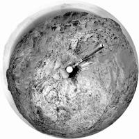
Here is Paul's full panorama from sol 1353 in circular form. It shows the tracks did follow the rock outcrops as I guessed in my map. Looks like we have a good run to the south now.
Phil
-------------------- ... because the Solar System ain't gonna map itself.
Also to be found posting similar content on https://mastodon.social/@PhilStooke Maps for download (free PDF: https://upload.wikimedia.org/wikipedia/comm...Cartography.pdf NOTE: everything created by me which I post on UMSF is considered to be in the public domain (NOT CC, public domain) |
|
|
|
|
|
|
May 31 2016, 01:04 AM
Post
#6
|
||
|
Senior Member Group: Members Posts: 2431 Joined: 30-January 13 From: Penang, Malaysia. Member No.: 6853 |
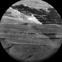
Sol 1356: Long-Distance ChemCam-RMI mosaic, centered on SSE - Mt Sharp. Quickly assembled in MS ICE using the 9 available Enhanced Data Product frames. Shows more of the detail of the extensive layering in the lower reaches of the mountain.
Width reduced to 2500 pxls
|
|
|
|
|
|
|
May 31 2016, 02:20 AM
Post
#7
|
||
 Member Group: Members Posts: 684 Joined: 24-July 15 Member No.: 7619 |
QUOTE (PaulH51 @ May 31 2016, 02:04 AM)  Sol 1356: Long-Distance ChemCam-RMI mosaic, centered on SSE - Mt Sharp. Quickly assembled in MS ICE using the 9 available Enhanced Data Product frames. Shows more of the detail of the extensive layering in the lower reaches of the mountain. Width reduced to 2500 pxls
Wow, just wow. Literally a picture worth a thousand words. |
|
|
|
|
|
|
May 31 2016, 03:24 PM
Post
#8
|
|
 Administrator Group: Admin Posts: 5172 Joined: 4-August 05 From: Pasadena, CA, USA, Earth Member No.: 454 |
New thread time! Now that Curiosity's wheels are back on Murray, we'll stick with this thread for a while. Here's a 3D route map giving some context for where we need to go next. It'll be roughly 2 km of driving with sand dunes on our left and the Murray Buttes on our right. I'm not sure if there are plans to do much in the way of science stops along that traverse; I guess it depends on how different the Murray is here compared to its appearance at Pahrump hills.
-------------------- My website - My Patreon - @elakdawalla on Twitter - Please support unmannedspaceflight.com by donating here.
|
|
|
|
|
May 31 2016, 11:16 PM
Post
#9
|
|
|
Senior Member Group: Members Posts: 2431 Joined: 30-January 13 From: Penang, Malaysia. Member No.: 6853 |
Another drive on sol 1357: ~7 meters West followed by a short bump to the North, see Midnight Planets
Hopefully we'll get enough of the end-of-drive NavCams to assemble the pano soon. |
|
|
|
|
Jun 1 2016, 11:04 PM
Post
#10
|
||
|
Senior Member Group: Members Posts: 2431 Joined: 30-January 13 From: Penang, Malaysia. Member No.: 6853 |
Curiosity Mission Update by Ryan anderson, dated 31 May 2016 - Sol 1358: A Simple Plan
QUOTE Our activities over the weekend went well, and after a couple of complicated multi-sol plans we get to do a nice simple one-sol plan today! The Sol 1358 plan starts with ChemCam observations of the targets Otiiha, Otjihase, Otjikoto, and Otjimbingwe to assess variations in the bedrock chemistry. Mastcam will document those targets, and then we will dump out our remaining Okoruso sample. APXS then has an overnight observation of the target Oudam. I was on downlink for ChemCam today, so while everyone was putting together the plan for today, I was busy analyzing the tons of great data that we got down over the long weekend!
|
|
|
|
|
|
|
Jun 2 2016, 01:25 AM
Post
#11
|
||
|
Senior Member Group: Members Posts: 2431 Joined: 30-January 13 From: Penang, Malaysia. Member No.: 6853 |
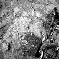
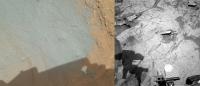
Sol 1358: The Okoruso drill sample dumped from CHIMRA (MAHLI & NavCam for context)
|
|
|
|
|
|
|
Jun 2 2016, 02:18 PM
Post
#12
|
|
|
Administrator Group: Admin Posts: 5172 Joined: 4-August 05 From: Pasadena, CA, USA, Earth Member No.: 454 |
It's fascinating how dark the dump pile looks in Navcam. Navcams have red/IR filters on them (600-800nm), so the (relatively) blue tailings pile looks a lot darker to Navcam than it does to Mastcam/MAHLI.
-------------------- My website - My Patreon - @elakdawalla on Twitter - Please support unmannedspaceflight.com by donating here.
|
|
|
|
|
Jun 2 2016, 11:01 PM
Post
#13
|
|
|
Senior Member Group: Members Posts: 2431 Joined: 30-January 13 From: Penang, Malaysia. Member No.: 6853 |
QUOTE (elakdawalla @ Jun 2 2016, 10:18 PM) It's fascinating how dark the dump pile looks in Navcam. When I shared that image elsewhere I had to add an arrow to point out the dump pile on the NavCam context image due to apparent colour differences And the latest from USGS:- Curiosity Mission Update by Ken Herkenhoff, dated 02 Jun 2016 - Sol 1360: Preparing to drill QUOTE Arm work continues to go well, so preparation for drilling and sample analysis is the focus of the Sol 1360 plan. First, CheMin will dump the Lubango and Okoruso drill samples out of their cells. Then ChemCam and Mastcam will observe a bright vein named "Charlottenfelder" and a bedrock target called "Chameis Bay" before arm activities resume. MAHLI will take close-up images of the Oudam drill target and a single image of the "footprint" that APXS likely made on the Okoruso dump pile yesterday. Overnight, CheMin will analyze an empty cell to provide a baseline measurement before receiving the new drill sample. Early the next morning, before handover to the next plan, observations of the Sun and sky will measure dust in the atmosphere over the rover and search for clouds and dust devils. The Right Mastcam will take a 10-image mosaic of the "Otjizonjati" outcrop northwest of the rover when it is well-illuminated by the morning sun. Finally, the RMI will acquire a 5-image mosaic of part of Aeolis Mons (Mount Sharp) toward the south. |
|
|
|
|
Jun 2 2016, 11:04 PM
Post
#14
|
|
|
Administrator Group: Admin Posts: 5172 Joined: 4-August 05 From: Pasadena, CA, USA, Earth Member No.: 454 |
I didn't expect them to drill again so soon. In hindsight, it makes sense; I guess they want to see if the Murray here is any different than it was on the other side of the plateau.
Also, I didn't know they could keep two different samples in CheMin at the same time! -------------------- My website - My Patreon - @elakdawalla on Twitter - Please support unmannedspaceflight.com by donating here.
|
|
|
|
|
Jun 3 2016, 01:04 AM
Post
#15
|
|
|
Senior Member Group: Members Posts: 2431 Joined: 30-January 13 From: Penang, Malaysia. Member No.: 6853 |
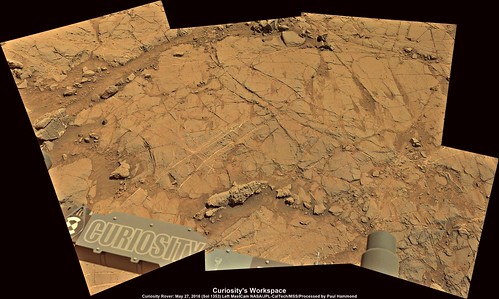
QUOTE (elakdawalla @ Jun 3 2016, 07:04 AM) I didn't expect them to drill again so soon. They have already completed the load tests and the overnight APXS, I guess we will know soon if they were acceptable. R-MastCam Mosaic featuring the drill target (center of the mosaic) assembled in MS ICE 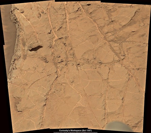 Flickr 1024x904 Flickr 3772x3330 |
|
|
|
|

|
Lo-Fi Version | Time is now: 20th September 2024 - 01:14 AM |
|
RULES AND GUIDELINES Please read the Forum Rules and Guidelines before posting. IMAGE COPYRIGHT |
OPINIONS AND MODERATION Opinions expressed on UnmannedSpaceflight.com are those of the individual posters and do not necessarily reflect the opinions of UnmannedSpaceflight.com or The Planetary Society. The all-volunteer UnmannedSpaceflight.com moderation team is wholly independent of The Planetary Society. The Planetary Society has no influence over decisions made by the UnmannedSpaceflight.com moderators. |
SUPPORT THE FORUM Unmannedspaceflight.com is funded by the Planetary Society. Please consider supporting our work and many other projects by donating to the Society or becoming a member. |
|