What is the theory on formation of this landform? |

  |
What is the theory on formation of this landform? |
 Feb 23 2011, 10:21 PM Feb 23 2011, 10:21 PM
Post
#1
|
||
|
Junior Member  Group: Members Posts: 91 Joined: 21-August 06 Member No.: 1063 |
Hi,
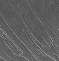
Can someone give me the current theory on how these landforms were made? I attached pic. They look like maybe carved out of ground rock from a side shooting lava blob but I dont know. These ones were found south of maxwell but I have seen them sometimes other spots. I might think they are splatters of hot rock that carved out of the flat local area but I am really guessing. Whats the official theory? thanks
Attached thumbnail(s)
|
|
 |
 
|
|
|
Feb 23 2011, 10:40 PM
Post
#2
|
|
|
Founder Group: Chairman Posts: 14432 Joined: 8-February 04 Member No.: 1 |
What's the source image.
|
|
|
|
|
Feb 23 2011, 11:14 PM
Post
#3
|
|
|
Solar System Cartographer Group: Members Posts: 10170 Joined: 5-April 05 From: Canada Member No.: 227 |
One possibility: Not splatters of rock on the surface, but more likely lava flowing under a hardened crust - the flows cover the surface, they begin to cool and harden, and the lava continues to flow under its card crust. Then in some places as the lava drains out the crust collapses into the voids.
Another possibility - extensive lava flows. Then a system of parallel fractures form, possibly over dykes (volcanic intrusions, lava pushing into the fractures). As the fractures open or the lava drains away (suggesting flows downhill from here) the surface collapses into the open fractures, creating pits and chains of coalescing pits, very much like those seen around Alba Patera on Mars - which might be a Martian version of a Venusian corona. But it would be good to see more of the scene, to get geological context. These features are common on Venus, not just found here. Phil -------------------- ... because the Solar System ain't gonna map itself.
Also to be found posting similar content on https://mastodon.social/@PhilStooke Maps for download (free PD: https://upload.wikimedia.org/wikipedia/comm...Cartography.pdf NOTE: everything created by me which I post on UMSF is considered to be in the public domain (NOT CC, public domain) |
|
|
|
|
Feb 23 2011, 11:17 PM
Post
#4
|
|
|
Junior Member Group: Members Posts: 91 Joined: 21-August 06 Member No.: 1063 |
fl63n358.img on cd mg_1115 directory fl66n348
|
|
|
|
|
Feb 23 2011, 11:21 PM
Post
#5
|
|
|
Senior Member Group: Members Posts: 3516 Joined: 4-November 05 From: North Wales Member No.: 542 |
QUOTE (ncc1701d @ Feb 23 2011, 10:21 PM)  how these landforms were made? No idea if there is an official theory, but I enjoy random questions like this. My first guess would be collapsed lava tubes. Flow rate and therefore diameter would depend on the local gradient. Where the gradient reduced enough the flows would widen and stop. Does the local gradient decrease from top left to bottom right across your image? If not I'm hopelessly wrong (which is very likely in any case). |
|
|
|
|
Feb 23 2011, 11:31 PM
Post
#6
|
||
|
Junior Member Group: Members Posts: 91 Joined: 21-August 06 Member No.: 1063 |
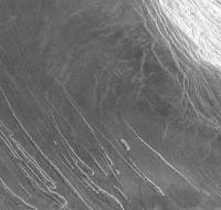
I like the pit theory you talking about. The shape furthest right in new image I attached leads me to believe your parallel fracture drainage pit concept. Its is not thin on first half and wide on the other.
and I guess the others look thin on one end and thick on the opposite is becuase of them forming going down hill if I understand you right. Any comparable structure like that happen on earth? perphaps even on a smaller scale if not large?
Attached thumbnail(s)
|
|
|
|
|
|
|
Feb 24 2011, 02:24 AM
Post
#7
|
|
|
Member Group: Members Posts: 890 Joined: 18-November 08 Member No.: 4489 |
from the image "fl63n358.img"
CODE MAP_RESOLUTION = 1408.131<PIXEL/DEGREE> MAP_SCALE = 0.075 <KM/PIXEL> [attachment=23922:fl63n358crop.png] so from the measurements right to left 60 px = 4.5 Km 37px = 2.775 Km and 76px= 5.7 Km so they are fairly large also this is a "left look" radar so they are valleys ( not mounds) collapsed lava tube ? |
|
|
|
|
Feb 24 2011, 02:35 AM
Post
#8
|
|
|
Founder Group: Chairman Posts: 14432 Joined: 8-February 04 Member No.: 1 |
The discontinuations look like classic collapsing lava tubes.
|
|
|
|
|
Feb 24 2011, 03:34 AM
Post
#9
|
|
|
Junior Member Group: Members Posts: 91 Joined: 21-August 06 Member No.: 1063 |
would "classic" collapsed lava tubes be so rounded around the edges? I dont know.
I am just looking at pics of colapsed lavatubes on earth they dont seem so rounded but I am looking at ground level. When I look at these or others I see on Venus they seem so lava or fluid like in their shapes. Any satellite photos of colapsed tubes on earth to compare? |
|
|
|
|
Feb 24 2011, 03:49 AM
Post
#10
|
|
|
Member Group: Members Posts: 890 Joined: 18-November 08 Member No.: 4489 |
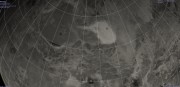
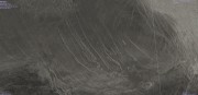
some context images
|
|
|
|
|

|
Lo-Fi Version | Time is now: 28th May 2024 - 03:20 PM |
|
RULES AND GUIDELINES Please read the Forum Rules and Guidelines before posting. IMAGE COPYRIGHT |
OPINIONS AND MODERATION Opinions expressed on UnmannedSpaceflight.com are those of the individual posters and do not necessarily reflect the opinions of UnmannedSpaceflight.com or The Planetary Society. The all-volunteer UnmannedSpaceflight.com moderation team is wholly independent of The Planetary Society. The Planetary Society has no influence over decisions made by the UnmannedSpaceflight.com moderators. |
SUPPORT THE FORUM Unmannedspaceflight.com is funded by the Planetary Society. Please consider supporting our work and many other projects by donating to the Society or becoming a member. |
|