Mission: Hayabusa 2 |

  |
Mission: Hayabusa 2 |
 Oct 29 2018, 08:35 AM Oct 29 2018, 08:35 AM
Post
#646
|
|
 Senior Member  Group: Members Posts: 1729 Joined: 3-August 06 From: 43° 35' 53" N 1° 26' 35" E Member No.: 1004 |
are you sure that the descent was unscheduled? or was it just unnannounced?
|
 |
 
|
| Guest_mcmcmc_* |
Oct 29 2018, 10:43 AM
Post
#647
|
|
Guests |
QUOTE (Paolo @ Oct 29 2018, 09:35 AM)  are you sure that the descent was unscheduled? or was it just unnannounced? It's not in the public schedule nor in the twitter feed; of course I don't know about private schedules. |
|
|
|
|
Oct 29 2018, 02:38 PM
Post
#648
|
|
|
Junior Member Group: Members Posts: 22 Joined: 15-November 14 Member No.: 7320 |
Not sure if that was posted before, but there is a very nice Space Science Review Issue about Hayabusa2 from July 2017. It wasn't free at the time I looked at it, but not no longer behind a pay wall. It's a lot of information, several very detailed papers about all the instruments and components. I especially enjoyed the papers about the impactor opration and the deployable camera.
Must read! https://link.springer.com/journal/11214/208/1/page/1 Edit: hmm, following the link I posted and not the the google link that brought me there, it seems the issue is still behind the paywall. :-( The google link somewhat brought me behind the wall and I can access all the papers. Which is this one: https://link.springer.com/article/10.1007/s11214-017-0338-8 and then click on the issue link to go back to the overview. |
|
|
|
| Guest_mcmcmc_* |
Oct 29 2018, 07:26 PM
Post
#649
|
|
Guests |
QUOTE (Paolo @ Oct 29 2018, 09:35 AM) are you sure that the descent was unscheduled? or was it just unnannounced? New mission now confirmed by twitter , but telemetries are still not regular: https://twitter.com/haya2_jaxa/status/1056838918694297602 "Tomorrow" in Japan already started at 15:00 UTC. Last recorded altitude was 11332m, descending at 4 cm/s at 07:14 UTC Earth time (but uploaded to web at 17:30); 12 hours elapsed, which should mean 1728m lower, hence lower than 10000m. Target is 5000m. Unfortunately my telemetry logger was not working for several hours due to a bug. 
|
|
|
|
| Guest_mcmcmc_* |
Oct 29 2018, 07:31 PM
Post
#650
|
|
Guests |
This version of my chart is still in beta but already quite usable: you can't yet select the data period, but you can change vertical scale and reference dates (telemetries use three dates: onboard, received and uploaded (to web) ).
https://programmi.000webhostapp.com/hayabus...dates-5000.html |
|
|
|
|
Oct 30 2018, 12:28 AM
Post
#651
|
|
|
Newbie Group: Members Posts: 14 Joined: 30-September 14 Member No.: 7269 |
https://twitter.com/haya2e_jaxa/status/1057065930927140864
HAYABUSA2@JAXA @haya2e_jaxa [BOX-C] Touchdown rehearsal, TD1-R3, is just over but we are beginning BOX-C operations. The spacecraft will perform low altitude observations at ~5km from today (October 30). After this, we plan to further lower the altitude for images near the touchdown candidate site, L08. 9:25 - 2018年10月30日 |
|
|
|
|
Oct 30 2018, 08:47 AM
Post
#652
|
|
|
Newbie Group: Members Posts: 14 Joined: 30-September 14 Member No.: 7269 |
http://www.hayabusa2.jaxa.jp/topics/20181030_TD1R3_CAMH/
Image taken with a small monitor camera (cam-h) in touchdown 1 rehearsal 3 (TD1-R3). The photograph was taken from the altitude of about 21m, which began to rise on October 25, 2018 (JST) every second. The rising speed is about 52cm/s. (Image credit: JAXA) 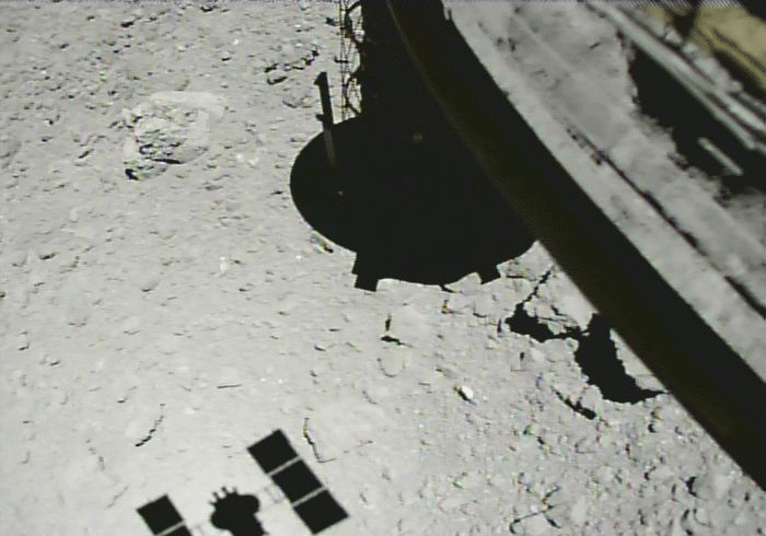 |
|
|
|
|
Oct 30 2018, 12:05 PM
Post
#653
|
|
|
Senior Member Group: Members Posts: 2082 Joined: 13-February 10 From: Ontario Member No.: 5221 |
Jaw-dropping! Thanks for finding this, brightening up my morning Yoichi!
According to the English twitter, another target marker was dropped off and tracked autonomously. |
|
|
|
|
Oct 31 2018, 01:46 AM
Post
#654
|
|
|
Newbie Group: Members Posts: 14 Joined: 30-September 14 Member No.: 7269 |
QUOTE (yoichi @ Oct 30 2018, 05:47 PM) http://www.hayabusa2.jaxa.jp/topics/20181030_TD1R3_CAMH/ Image taken with a small monitor camera (cam-h) in touchdown 1 rehearsal 3 (TD1-R3). The photograph was taken from the altitude of about 21m, which began to rise on October 25, 2018 (JST) every second. The rising speed is about 52cm/s. (Image credit: JAXA) press release in english http://www.hayabusa2.jaxa.jp/en/topics/20181030e_TD1R3_CAMH/ |
|
|
|
|
Nov 1 2018, 05:33 PM
Post
#655
|
||
|
Solar System Cartographer Group: Members Posts: 10153 Joined: 5-April 05 From: Canada Member No.: 227 |
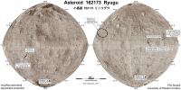
Another map update to include dropping the second target marker.
Any corrections or additions including feature names are very welcome. Phil
-------------------- ... because the Solar System ain't gonna map itself.
Also to be found posting similar content on https://mastodon.social/@PhilStooke Maps for download (free PD: https://upload.wikimedia.org/wikipedia/comm...Cartography.pdf NOTE: everything created by me which I post on UMSF is considered to be in the public domain (NOT CC, public domain) |
|
|
|
|
|
| Guest_mcmcmc_* |
Nov 1 2018, 05:54 PM
Post
#656
|
|
Guests |
During past hours Hayabusa silently performed a low altitude mission, going down to 2300 m; now it's rising since 15 hours and it has reached 7400m altitude, and it's still rising at 20 cm/s.
 No info about it on twitter and official site. |
|
|
|
| Guest_mcmcmc_* |
Nov 1 2018, 05:59 PM
Post
#657
|
||
|
Guests |
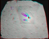
These images attempt showing the paths followed by H2 during TD1-R1A (right long blue path, ONC-W camera) and TD1-R3 (left short blue path, horn camera).
They are the result of the 3d reconstruction of landing site using 3DF Zephyr free, which also shows (but unfortunately does not export) calculated position of cameras. This is the 3d reconstruction of the landing site: https://sketchfab.com/models/95adee20ea9145...1064df8418b99c7 I don't get why they decided to land so close to a house-tall boulder.
Attached thumbnail(s)
|
||
|
|
|
||
| Guest_mcmcmc_* |
Nov 1 2018, 06:37 PM
Post
#658
|
|
Guests |
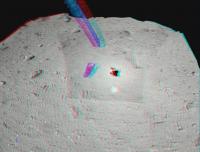
Although not very scientific because I don't have all the needed tools and skills to perform a precise job, this model is interesting because it gives a sense of scale of the landing site:
https://sketchfab.com/models/f66ecf2b03b545...969b4d5aa81d99c |
|
|
|
|
Nov 1 2018, 07:15 PM
Post
#659
|
|
|
Member Group: Members Posts: 156 Joined: 22-May 09 From: Ireland Member No.: 4792 |
QUOTE (mcmcmc @ Nov 1 2018, 06:59 PM) These images attempt showing the paths followed by H2 during TD1-R1A (right long blue path, ONC-W camera) and TD1-R3 (left short blue path, horn camera). They are the result of the 3d reconstruction of landing site using 3DF Zephyr free, which also shows (but unfortunately does not export) calculated position of cameras. This is the 3d reconstruction of the landing site: https://sketchfab.com/models/95adee20ea9145...1064df8418b99c7 I don't get why they decided to land so close to a house-tall boulder. |
|
|
|
| Guest_mcmcmc_* |
Nov 3 2018, 08:33 PM
Post
#660
|
|
Guests |
Mistery revealed (about low altitude mission of previous days): they were looking for the target maker, which is confirmed to be visible from 2.4 km away:
https://twitter.com/haya2_jaxa/status/1058612614924652544 |
|
|
|
|

|
Lo-Fi Version | Time is now: 28th April 2024 - 08:17 PM |
|
RULES AND GUIDELINES Please read the Forum Rules and Guidelines before posting. IMAGE COPYRIGHT |
OPINIONS AND MODERATION Opinions expressed on UnmannedSpaceflight.com are those of the individual posters and do not necessarily reflect the opinions of UnmannedSpaceflight.com or The Planetary Society. The all-volunteer UnmannedSpaceflight.com moderation team is wholly independent of The Planetary Society. The Planetary Society has no influence over decisions made by the UnmannedSpaceflight.com moderators. |
SUPPORT THE FORUM Unmannedspaceflight.com is funded by the Planetary Society. Please consider supporting our work and many other projects by donating to the Society or becoming a member. |
|