Updated Titan Map |

  |
Updated Titan Map |
 Oct 18 2007, 05:59 PM Oct 18 2007, 05:59 PM
Post
#136
|
|
 Member  Group: Members Posts: 809 Joined: 11-March 04 Member No.: 56 |
QUOTE (rlorenz @ Oct 18 2007, 05:00 PM)  I think Phil is picking up on my possibly unfair skepticism : if it's not Scottish, it's crap. Same for RADAR. Ralphocentric view is - orientation of features is contrary to expectation , could it be an artifact? If so, it is then an ISS artifact. If it is real, it would be very interesting. Well, the more northerly of that set of ISS images overlaps with a radar swath, so you could compare them. I'm having no luck finding a more detailed version of that swath, though -- I expect that won't be a problem for you. 
|
 |
 
|
|
Oct 18 2007, 07:17 PM
Post
#137
|
||
 Senior Member Group: Moderator Posts: 2785 Joined: 10-November 06 From: Pasadena, CA Member No.: 1345 |
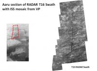
QUOTE (David @ Oct 18 2007, 01:59 PM) Well, the more northerly of that set of ISS images overlaps with a radar swath, so you could compare them. I'm having no luck finding a more detailed version of that swath, though -- I expect that won't be a problem for you. The more northerly set of images is part of the T16 RADAR Swath (the leftmost section) which has been released as PIA09112 (available here). The right end of this swath is the section that drops down into Aaru basin. Here is a graphic which shows where T16 ends up in relation to the ISS "verticle lines".
There is a "secret swath" that passes much closer to the Playboy peninsula and also overlaps with some of the Ta RADAR swath. Unfortunately, this has not yet been released. [I'm drooling with anticipation since this might've come close to a cool-o interesting multi-ring feature]. -Mike -------------------- Some higher resolution images available at my photostream: http://www.flickr.com/photos/31678681@N07/
|
|
|
|
|
|
|
Oct 18 2007, 07:24 PM
Post
#138
|
|
|
Solar System Cartographer Group: Members Posts: 10153 Joined: 5-April 05 From: Canada Member No.: 227 |
Duh - sorry, Ralph. I thought you were making a joke about the n-s trending straight lines at the top of the map... reprojected grid lines. I should never have doubted you. I never will again... well, not very often.
Phil -------------------- ... because the Solar System ain't gonna map itself.
Also to be found posting similar content on https://mastodon.social/@PhilStooke Maps for download (free PD: https://upload.wikimedia.org/wikipedia/comm...Cartography.pdf NOTE: everything created by me which I post on UMSF is considered to be in the public domain (NOT CC, public domain) |
|
|
|
|
Oct 18 2007, 07:53 PM
Post
#139
|
|
|
Member Group: Members Posts: 809 Joined: 11-March 04 Member No.: 56 |
QUOTE (Juramike @ Oct 18 2007, 07:17 PM) The more northerly set of images is part of the T16 RADAR Swath (the leftmost section) which has been released as PIA09112 (available here). The right end of this swath is the section that drops down into Aaru basin. Here is a graphic which shows where T16 ends up in relation to the ISS "verticle lines". Thanks, Mike! That certainly does make it look like the seeming N-S dune field is artifactual -- there are real dunes in there, but they're going W-E. I'll certainly look forward to further radar swaths in this region. |
|
|
|
|
Oct 18 2007, 11:46 PM
Post
#140
|
||
 Senior Member Group: Moderator Posts: 3233 Joined: 11-February 04 From: Tucson, AZ Member No.: 23 |
Ralph, those are artifacts. The original CB3 images (or MT1 images, I can't recall at the moment) were taken in 8-bit mode in that area, so you see some effects from the dithering. And regarding the implication that if it isn't RADAR, it's cr@p, I'm telling!!!
 BTW, here is the updated map with all RADAR SAR swaths in the PDS at the moment (including all the HiSAR stuff).
Attached thumbnail(s)
-------------------- &@^^!% Jim! I'm a geologist, not a physicist!
The Gish Bar Times - A Blog all about Jupiter's Moon Io |
|
|
|
|
|
|
Oct 19 2007, 12:07 AM
Post
#141
|
|
|
Member Group: Members Posts: 813 Joined: 29-December 05 From: NE Oh, USA Member No.: 627 |
VP...
Right now, you rule, man!!!!! Even if I am more partial to the detail in the SAR... Craig |
|
|
|
|
Oct 19 2007, 02:31 PM
Post
#142
|
|
|
Senior Member Group: Moderator Posts: 2785 Joined: 10-November 06 From: Pasadena, CA Member No.: 1345 |
OK, I've [almost] given up.
Does anyone have any idea where the T19 Distant targeted look fits in? I've been struggling to fit this in and just haven't been able make it work. -Mike -------------------- Some higher resolution images available at my photostream: http://www.flickr.com/photos/31678681@N07/
|
|
|
|
|
Oct 19 2007, 04:07 PM
Post
#143
|
|
 Member Group: Members Posts: 610 Joined: 23-February 07 From: Occasionally in Columbia, MD Member No.: 1764 |
QUOTE (volcanopele @ Oct 18 2007, 07:46 PM) Ralph, those are artifacts. The original CB3 images (or MT1 images, I can't recall at the moment) were taken in 8-bit mode in that area, so you see some effects from the dithering. And regarding the implication that if it isn't RADAR, it's cr@p, I'm telling!!! Thanks VP - I figured that was the case. I guess a partial retraction is in order - IF you take out the artifacts, and IF you somehow know whether a dark splot is a sand sea or a methane lake, THEN the imaging is really pretty interesting ..... |
|
|
|
|
Oct 19 2007, 04:26 PM
Post
#144
|
|
|
Senior Member Group: Moderator Posts: 3233 Joined: 11-February 04 From: Tucson, AZ Member No.: 23 |
QUOTE (rlorenz @ Oct 19 2007, 09:07 AM) IF you somehow know whether a dark splot is a sand sea or a methane lake, THEN the imaging is really pretty interesting ..... That's what my divining rod is for. -------------------- &@^^!% Jim! I'm a geologist, not a physicist!
The Gish Bar Times - A Blog all about Jupiter's Moon Io |
|
|
|
|
Oct 19 2007, 05:01 PM
Post
#145
|
||
|
Senior Member Group: Moderator Posts: 2785 Joined: 10-November 06 From: Pasadena, CA Member No.: 1345 |
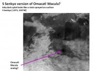
Speaking of dark splots...the new mosaic shows a really nice dark splot down in S Senkyo basin.
Could this be an artifact or a Senkyo version of Omacatl Macula? (It seemed to be present on the older maps as well, the newer mosaic brings out the contrast). -Mike [EDIT: Feature indicated]:
-------------------- Some higher resolution images available at my photostream: http://www.flickr.com/photos/31678681@N07/
|
|
|
|
|
|
|
Oct 19 2007, 06:20 PM
Post
#146
|
|
|
Senior Member Group: Moderator Posts: 3233 Joined: 11-February 04 From: Tucson, AZ Member No.: 23 |
That little spot is one of my favorite little areas. Not sure what it is. It isn't an artifact, it has been seen in a number of mosaics covering this region. One possibility is that it could be a buried impact crater. In this area, it would appear we have bright material partly covered in dunes, but we have this circular feature that is much darker than the surrounding terrain. Perhaps this is an impact crater that has been subsequently filled in with sediment, then covered in dunes. Another possibility is that it is similar to Omacatl, a cryovolcano with an ashfall deposit, but this really doesn't have the same, parabolic shape that Omacatl and Elpis have.
-------------------- &@^^!% Jim! I'm a geologist, not a physicist!
The Gish Bar Times - A Blog all about Jupiter's Moon Io |
|
|
|
|
Oct 19 2007, 06:54 PM
Post
#147
|
|
|
Senior Member Group: Moderator Posts: 2785 Joined: 10-November 06 From: Pasadena, CA Member No.: 1345 |
The parabolic inky black shape of Omacatl and Elpis Macula(e?) would be due to the prevailing winds causing the cryoashfall drift.
But the wind strength varies as Titan moves around in it's orbit, if the General Circulation Models are correct. So...maybe the S Senkyo splot [name needed here] was a single-shot deal done during a calm-wind period. That would give it a nice regular circular diffusion to the fallout pattern rather than a downwind parabola. Any chance this feature was imaged in the "secret unreleased RADAR swath"? -Mike -------------------- Some higher resolution images available at my photostream: http://www.flickr.com/photos/31678681@N07/
|
|
|
|
|
Oct 19 2007, 07:14 PM
Post
#148
|
|
|
Senior Member Group: Moderator Posts: 3233 Joined: 11-February 04 From: Tucson, AZ Member No.: 23 |
I doubt that. Winds can vary, but I doubt there would dead calm for the duration or an eruption or eruptions, particularly at the altitude of the top of the eruption column.
Okay, I'll bite. What secret, unreleased SAR swath? T23? -------------------- &@^^!% Jim! I'm a geologist, not a physicist!
The Gish Bar Times - A Blog all about Jupiter's Moon Io |
|
|
|
|
Oct 20 2007, 01:15 AM
Post
#149
|
|
|
Senior Member Group: Moderator Posts: 2785 Joined: 10-November 06 From: Pasadena, CA Member No.: 1345 |
Yup. T23 (Jan 13, 2007) RADAR Swath.
I'm hoping they release it soon..... The few images they've released (Ganesa Macula, half-crater image) are teasingly cool-o.... -Mike -------------------- Some higher resolution images available at my photostream: http://www.flickr.com/photos/31678681@N07/
|
|
|
|
|
Oct 27 2007, 06:19 PM
Post
#150
|
|
 Senior Member Group: Members Posts: 1887 Joined: 20-November 04 From: Iowa Member No.: 110 |
Some new images of Titan were taken on October 22. They cover the lowest resolution area on the latest Titan maps.
http://saturn.jpl.nasa.gov/multimedia/imag...iImageID=130136 |
|
|
|
|

|
Lo-Fi Version | Time is now: 27th April 2024 - 10:02 AM |
|
RULES AND GUIDELINES Please read the Forum Rules and Guidelines before posting. IMAGE COPYRIGHT |
OPINIONS AND MODERATION Opinions expressed on UnmannedSpaceflight.com are those of the individual posters and do not necessarily reflect the opinions of UnmannedSpaceflight.com or The Planetary Society. The all-volunteer UnmannedSpaceflight.com moderation team is wholly independent of The Planetary Society. The Planetary Society has no influence over decisions made by the UnmannedSpaceflight.com moderators. |
SUPPORT THE FORUM Unmannedspaceflight.com is funded by the Planetary Society. Please consider supporting our work and many other projects by donating to the Society or becoming a member. |
|