Continuing into Glenelg, Leaving Rocknest behind, sols 102-166 (Nov 18 2012-Jan 23, 2013) |

  |
Continuing into Glenelg, Leaving Rocknest behind, sols 102-166 (Nov 18 2012-Jan 23, 2013) |
 Nov 26 2012, 11:03 PM Nov 26 2012, 11:03 PM
Post
#61
|
|
 Administrator  Group: Admin Posts: 5172 Joined: 4-August 05 From: Pasadena, CA, USA, Earth Member No.: 454 |
According to the caption of a version of the Rocknest mastcam pan released by the mission today, the site that Curiosity drove to after Rocknest (where the sol 107 panorama was taken) is called "Point Lake."
-------------------- My website - My Patreon - @elakdawalla on Twitter - Please support unmannedspaceflight.com by donating here.
|
 |
 
|
|
Nov 26 2012, 11:10 PM
Post
#62
|
|
 Member Group: Members Posts: 161 Joined: 12-August 12 From: Hillsborough, NJ Member No.: 6546 |
Well, this Point Lake it awesome.
 Do you know if that dune that is all the way to the left is named? It's actually 3 or more if I'm not mistaken. -------------------- |
|
|
|
|
Nov 26 2012, 11:24 PM
Post
#63
|
|
|
Senior Member Group: Members Posts: 3516 Joined: 4-November 05 From: North Wales Member No.: 542 |
QUOTE (Don1 @ Nov 26 2012, 08:51 AM)  I think that Glenelg may be just what it looks like. A dried up lake bed with a fairly obvious shoreline. There are two things to explain - a remarkably clean and empty basin, and the fact that this is just the lowest part of the high thermal inertia unit (HTI). I suggest HTI indicates exposure of ancient rocks long predating the fan. Something exposed and maybe eroded those ancient rocks. That process was able to operate on a slope and wasn't confined to the Glenelg basin. That's the first puzzle. The second is the basin itself. What created it and what may have occupied it? Whatever it was it's gone. The basin has distinct margins to the right of our view, but to the left it rises into the rest of the HTI unit without any obvious 'shoreline'. |
|
|
|
|
Nov 26 2012, 11:32 PM
Post
#64
|
|
|
Member Group: Members Posts: 362 Joined: 13-April 06 From: Malta Member No.: 741 |
I suppose that the Glenelg bedrock composition would have been identified by CRISM on MRO??!
|
|
|
|
|
Nov 27 2012, 05:14 AM
Post
#65
|
|
|
Junior Member Group: Members Posts: 94 Joined: 11-August 12 Member No.: 6536 |
QUOTE (ngunn @ Nov 26 2012, 03:24 PM) There are two things to explain - a remarkably clean and empty basin, and the fact that this is just the lowest part of the high thermal inertia unit (HTI). I think that the crater floor is partly filled with several alluvial fans, and that the 'basin' is simply the space that is left between the alluvial fans. There may also be some material which came down from Mt Sharp to form the unit to the right. I think the basin is clean because the surface is young compared to the rest of the Martian surface. The older, rockier more cratered surfaces are buried beneath material left behind when the last lake evaporated. When Mars really dried out, the sediments dessicated and cracked into polygons. Like dry lakes in the Mojave, it may only have been wet for short periods. The rock composition at Glenelg was not identified by CRISM, other than that it had high thermal inertia. Hopefully Curiosity will teach MRO to recognise a new type of material. |
|
|
|
|
Nov 27 2012, 06:20 AM
Post
#66
|
|
|
Administrator Group: Admin Posts: 5172 Joined: 4-August 05 From: Pasadena, CA, USA, Earth Member No.: 454 |
Before you go off the deep end arm-waving about Gale geology, I suggest you visit the MSL FAQ thread and follow the links to resources on Gale geomorphology, geology, composition, etc. This is not a dried-up lakebed. It's an erosionally exposed surface. Also, CRISM didn't measure thermal inertia, THEMIS did. Curiosity can, and will, ground-truth orbital observations.
-------------------- My website - My Patreon - @elakdawalla on Twitter - Please support unmannedspaceflight.com by donating here.
|
|
|
|
|
Nov 27 2012, 11:56 AM
Post
#67
|
||
 Member Group: Members Posts: 215 Joined: 23-October 12 From: Russia Member No.: 6725 |
They are beautiful. I waited long ago this shot.
Full panorama (14,7 mb) Medium (2,3 mb)
Attached thumbnail(s)
-------------------- My blog on Patreon
|
|
|
|
|
|
|
Nov 27 2012, 05:44 PM
Post
#68
|
|
 Senior Member Group: Members Posts: 1619 Joined: 12-February 06 From: Bergerac - FR Member No.: 678 |
Wow, this is getting much BIGGER
 Some extra frames coming from Sol 109. Some extra frames coming from Sol 109.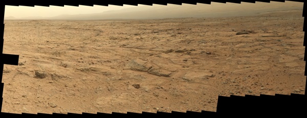
-------------------- |
|
|
|
|
Nov 27 2012, 07:58 PM
Post
#69
|
|
|
Member Group: Members Posts: 706 Joined: 22-April 05 Member No.: 351 |
I think Curiosity may be spending awhile there...
-------------------- |
|
|
|
|
Nov 27 2012, 08:00 PM
Post
#70
|
||
|
Newbie Group: Members Posts: 13 Joined: 27-June 08 Member No.: 4240 |
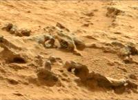
So many features in that image to look at ! I want to be there
|
|
|
|
|
|
|
Nov 27 2012, 10:06 PM
Post
#71
|
|
|
Junior Member Group: Members Posts: 26 Joined: 3-August 12 Member No.: 6455 |
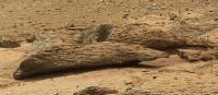
QUOTE (rob66 @ Nov 27 2012, 12:00 PM) So many features in that image to look at ! I want to be there What are those concentric "ribs" sorry, I know, I know, but I can't be the only one that jumped out too? |
|
|
|
|
Nov 27 2012, 10:17 PM
Post
#72
|
|
|
Administrator Group: Admin Posts: 5172 Joined: 4-August 05 From: Pasadena, CA, USA, Earth Member No.: 454 |
It is totally fine on this forum to describe things as looking like "ribs" or "sea lions" as long as you are not asserting that that is what they are!
I'm curious too, it must be some trick of lighting but I can't wrap my head around the geometry.
-------------------- My website - My Patreon - @elakdawalla on Twitter - Please support unmannedspaceflight.com by donating here.
|
|
|
|
|
Nov 27 2012, 10:24 PM
Post
#73
|
|
|
Solar System Cartographer Group: Members Posts: 10151 Joined: 5-April 05 From: Canada Member No.: 227 |
http://astrogeology.usgs.gov/news/item/sol...yellowknife-bay
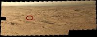
Tomorrow! A short drive coming up, just a bump to put the arm down. Phil -------------------- ... because the Solar System ain't gonna map itself.
Also to be found posting similar content on https://mastodon.social/@PhilStooke Maps for download (free PD: https://upload.wikimedia.org/wikipedia/comm...Cartography.pdf NOTE: everything created by me which I post on UMSF is considered to be in the public domain (NOT CC, public domain) |
|
|
|
|
Nov 27 2012, 10:29 PM
Post
#74
|
|
|
Junior Member Group: Members Posts: 26 Joined: 3-August 12 Member No.: 6455 |
QUOTE (elakdawalla @ Nov 27 2012, 02:17 PM) It is totally fine on this forum to describe things as looking like "ribs" or "sea lions" as long as you are not asserting that that is what they are! I'm curious too, it must be some trick of lighting but I can't wrap my head around the geometry.I have been scanning the full pan awhile looking for them and can't seem to locate them. I would have to agree with you that it will most likely end up being some trick of light. That being said there are some very very interesting structures in this terrain, what an incredible site the science team must be over the moon with this place
|
|
|
|
|
Nov 27 2012, 11:07 PM
Post
#75
|
|
|
Newbie Group: Members Posts: 7 Joined: 18-September 12 Member No.: 6655 |
|
|
|
|
|

|
Lo-Fi Version | Time is now: 26th April 2024 - 03:20 AM |
|
RULES AND GUIDELINES Please read the Forum Rules and Guidelines before posting. IMAGE COPYRIGHT |
OPINIONS AND MODERATION Opinions expressed on UnmannedSpaceflight.com are those of the individual posters and do not necessarily reflect the opinions of UnmannedSpaceflight.com or The Planetary Society. The all-volunteer UnmannedSpaceflight.com moderation team is wholly independent of The Planetary Society. The Planetary Society has no influence over decisions made by the UnmannedSpaceflight.com moderators. |
SUPPORT THE FORUM Unmannedspaceflight.com is funded by the Planetary Society. Please consider supporting our work and many other projects by donating to the Society or becoming a member. |
|