Radar And Mariner 10, Best possible mapping, pre-Messenger |

  |
Radar And Mariner 10, Best possible mapping, pre-Messenger |
 Dec 6 2007, 08:21 PM Dec 6 2007, 08:21 PM
Post
#69
|
|
|
Merciless Robot  Group: Admin Posts: 8783 Joined: 8-December 05 From: Los Angeles Member No.: 602 |
QUOTE (JRehling @ Dec 6 2007, 11:34 AM)  We're going to see a brand new planet when those first Messenger images come in. Yeah, I think that's a truism based on experience. Seems like our initial flybys almost invariably miss the most interesting features of a given target for whatever reason... -------------------- A few will take this knowledge and use this power of a dream realized as a force for change, an impetus for further discovery to make less ancient dreams real.
|
 |
 
|
|
Dec 6 2007, 09:01 PM
Post
#70
|
||
|
Member Group: Members Posts: 378 Joined: 21-April 05 From: Portugal Member No.: 347 |
Hi,
Ok, here's the familiar Mercury map with a color/albedo overlay from two Mariner 10 images made from different filters. Colors are approximate and perhaps a little to saturated but it's a start.
-------------------- _______________________
www.astrosurf.com/nunes |
|
|
|
|
|
|
Dec 6 2007, 09:39 PM
Post
#71
|
||
 Member Group: Members Posts: 106 Joined: 26-September 05 Member No.: 508 |
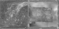
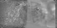
Here it is. Some notes about the map: It was constructed by me from the mosaics created for the Atlas of Mercury by NASA, (thanks to NSSDC for supplying the digital data). Becuse of discrepancies in the original mosaics this map may have errors as large as a few degrees. The original is 12K but only 4K fits to the 1MB limit here. With other regions added we may have to compress it more.
It is in simple cylindrical projection with 0 degrees longitude at the center. Some of the missing parts are the missing parts of the mosaics which are possible to fill with Mariner 10 data. First I think we should do this. And please add the radar data last as they have North-South ambiguity.
Attached thumbnail(s)
|
|
|
|
|
|
|
Dec 7 2007, 09:33 AM
Post
#72
|
||
|
Member Group: Members Posts: 106 Joined: 26-September 05 Member No.: 508 |
And here is version 2 with some fills.
Attached thumbnail(s)
|
|
|
|
|
|
|
Dec 7 2007, 05:58 PM
Post
#73
|
||
 Member Group: Members Posts: 146 Joined: 23-August 06 From: Vriezenveen, Netherlands Member No.: 1067 |
Here's a map of Mercury that I've been using for a couple of months now, I've added some radar information that's available on the web.
|
|
|
|
|
|
|
Dec 8 2007, 02:11 AM
Post
#74
|
||
|
Newbie Group: Members Posts: 16 Joined: 8-August 07 Member No.: 3138 |
QUOTE (CAP-Team @ Dec 7 2007, 12:58 PM) Here's a map of Mercury that I've been using for a couple of months now, I've added some radar information that's available on the web.
This map includes recent (reported within last 2 wks) amateur imaging (290-360 deg) by John Boudreau and our SOAR telescope imaging from earlier in the yr (185-290 deg), only to +-70 deg lat shown however. Alignment along longitudes of bright features (all rayed radar craters) is an artifact of the phase correction. Agreement with rayed radar craters and their diameters is given in our paper. http://stew.physics.unc.edu/MercuryComposite.jpg ( large image removed, replaced with link. Not everyone has 100 Mbit internet and 2500 pixel wide monitors - DOUG) |
|
|
|
|
|
|
Dec 8 2007, 02:42 AM
Post
#75
|
|
 Senior Member Group: Admin Posts: 4763 Joined: 15-March 05 From: Glendale, AZ Member No.: 197 |
Welcome Gerald. Thanks for the links to your paper.
-------------------- If Occam had heard my theory, things would be very different now.
|
|
|
|
|
Dec 8 2007, 10:17 AM
Post
#76
|
|
|
Member Group: Members Posts: 106 Joined: 26-September 05 Member No.: 508 |
Hi gcecil, thanks for the map but it seems to have some serious scale problems, Mariner 10 data covers more longitudes than it should. I think there was a mistake in compositing.
|
|
|
|
|
Dec 8 2007, 11:46 AM
Post
#77
|
|
|
Senior Member Group: Members Posts: 1870 Joined: 20-February 05 Member No.: 174 |
Mariner 10 took a series of approach <crescent> data for something like 6 days and outgoing data for maybe 3. Granted, the furthest out data is pretty horribly low rez, but the data shows stuff beyond the terminator on both approach and flyout. That's how the large crater "Mozart", south of Caloris, was discovered. It's not in the high rez mosaics.
Some of the data was lost or truncated by camera wander due to Mariner's large attitude control slop, and I vaguely recall some color band data may have been smeared by the wander, or some data was over-exposed, but I've always wanted to see the several frame zoom "movie" from approach and flyout, both at native resolution, and rescaled to a uniform diameter. |
|
|
|
|
Dec 8 2007, 12:13 PM
Post
#78
|
|
|
Member Group: Members Posts: 106 Joined: 26-September 05 Member No.: 508 |
I am not sure if edstrick's post is an answer to my post but let me make it clear: Mariner 10 high res data covers 190 to 10 degrees longitude, not 190 to -10 as in gcecil's map. That map has a scale problem.
|
|
|
|
|
Dec 8 2007, 01:19 PM
Post
#79
|
||
|
Newbie Group: Members Posts: 16 Joined: 8-August 07 Member No.: 3138 |
QUOTE (Tayfun Öner @ Dec 8 2007, 07:13 AM) I am not sure if edstrick's post is an answer to my post but let me make it clear: Mariner 10 high res data covers 190 to 10 degrees longitude, not 190 to -10 as in gcecil's map. That map has a scale problem. Yup, scale was messed up when I cutoff at +/-70 lat. Fixed now, so reposting with proper format. Thank you! This map
|
|
|
|
|
|
|
Dec 8 2007, 02:35 PM
Post
#80
|
||
|
Member Group: Members Posts: 106 Joined: 26-September 05 Member No.: 508 |
Here is Version 3 with optical data added from Baumgardner et al. Cosmetically corrected for Celestia.
Attached thumbnail(s)
|
|
|
|
|
|
|
Dec 9 2007, 10:11 AM
Post
#81
|
|
|
Senior Member Group: Members Posts: 1870 Joined: 20-February 05 Member No.: 174 |
I didn't spot the scale problem, I was just pointing that to some extend, Mariner 10 converage extends beyond the high-rez mosaic's terminations at the terminators.
Did Mariner really say "I'll be back!"? |
|
|
|
|
Dec 14 2007, 03:56 AM
Post
#82
|
||
 Interplanetary Dumpster Diver Group: Admin Posts: 4404 Joined: 17-February 04 From: Powell, TN Member No.: 33 |
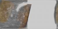
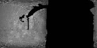
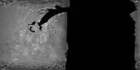
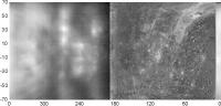
Here is an example of a Mariner set that shows a bit beyond what the high resolution images show. This is the same set of images, processed to look relatively natural on the left and with heavy high-pass filtering on the right.
-------------------- |
|
|
|
|
|
|
Dec 30 2007, 09:13 AM
Post
#83
|
||
 Member Group: Members Posts: 568 Joined: 20-April 05 From: Silesia Member No.: 299 |
I recognize that many of you are waiting for new images of Mercury, but you can't also see old images.
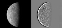
Tape MVE_033 Image 091 (29 November 1973) -------------------- Free software for planetary science (including Cassini Image Viewer).
http://members.tripod.com/petermasek/marinerall.html |
|
|
|
|
|
|

|
Lo-Fi Version | Time is now: 7th May 2024 - 01:17 PM |
|
RULES AND GUIDELINES Please read the Forum Rules and Guidelines before posting. IMAGE COPYRIGHT |
OPINIONS AND MODERATION Opinions expressed on UnmannedSpaceflight.com are those of the individual posters and do not necessarily reflect the opinions of UnmannedSpaceflight.com or The Planetary Society. The all-volunteer UnmannedSpaceflight.com moderation team is wholly independent of The Planetary Society. The Planetary Society has no influence over decisions made by the UnmannedSpaceflight.com moderators. |
SUPPORT THE FORUM Unmannedspaceflight.com is funded by the Planetary Society. Please consider supporting our work and many other projects by donating to the Society or becoming a member. |
|