Updated Titan Map |

  |
Updated Titan Map |
 Sep 9 2006, 09:46 PM Sep 9 2006, 09:46 PM
Post
#1
|
|
 Senior Member  Group: Members Posts: 1887 Joined: 20-November 04 From: Iowa Member No.: 110 |
I'm looking for a recent map ot Titan. Steve Albers's page links to one done by Fridger Schrempp in April 2005. Cassini has done a dozen flybys since then. Does anyone know if an updated map has been released.
|
 |
 
|
|
Sep 10 2006, 12:48 AM
Post
#2
|
|
|
Senior Member Group: Members Posts: 1276 Joined: 25-November 04 Member No.: 114 |
I believe we have one coming soon!?
VP did talk about it earlier this year. |
|
|
|
|
Sep 10 2006, 02:36 AM
Post
#3
|
|
 Senior Member Group: Moderator Posts: 3233 Joined: 11-February 04 From: Tucson, AZ Member No.: 23 |
It's going
 I'm hoping to have it done in the next couple of weeks. -------------------- &@^^!% Jim! I'm a geologist, not a physicist!
The Gish Bar Times - A Blog all about Jupiter's Moon Io |
|
|
|
|
Sep 10 2006, 03:32 AM
Post
#4
|
|
|
Senior Member Group: Members Posts: 1276 Joined: 25-November 04 Member No.: 114 |
^ Wow I got goose bumps!!
Very excited now! 
|
|
|
|
|
Oct 10 2006, 07:45 PM
Post
#5
|
|
 Member Group: Members Posts: 146 Joined: 23-August 06 From: Vriezenveen, Netherlands Member No.: 1067 |
Any idea when the new map is released?

|
|
|
|
|
Oct 10 2006, 11:16 PM
Post
#6
|
|
|
Senior Member Group: Moderator Posts: 3233 Joined: 11-February 04 From: Tucson, AZ Member No.: 23 |
Anytime between 20 minutes ago and next year.
-------------------- &@^^!% Jim! I'm a geologist, not a physicist!
The Gish Bar Times - A Blog all about Jupiter's Moon Io |
|
|
|
|
Oct 11 2006, 06:57 AM
Post
#7
|
|
 Senior Member Group: Members Posts: 3648 Joined: 1-October 05 From: Croatia Member No.: 523 |
Umm...Is that estimate given with 3-sigma confidence or?
-------------------- |
|
|
|
|
Oct 11 2006, 10:02 AM
Post
#8
|
|
|
Senior Member Group: Members Posts: 1870 Joined: 20-February 05 Member No.: 174 |
"...Anytime between 20 minutes ago and next year...."
REAL-SOON-NOW: Anytime between now and the decay of the last proton in the universe. |
|
|
|
|
Oct 11 2006, 10:27 AM
Post
#9
|
|
 Member Group: Members Posts: 562 Joined: 29-March 05 Member No.: 221 |
I always liked this method from the How to destroy the earth website, I know it is a little of topic but relevent to the last comment nonetheless.
You will need: all-surpassing patience Method: If the Big Crunch doesn't happen, and the Big Rip doesn't happen either, then we come back to the third option: the Big Chill. For this, the universe will just expand, forever. The laws of thermodynamics take over. Every galaxy becomes isolated from its neighbours. All the stars burn out. Everything gets colder until it's all the same temperature. And after that, nothing ever changes in the universe. For eternity. A lot can happen in an eternity. Protons, for example, while incredibly stable, are believed to eventually decay like any other particle. So simply wait for a period of time of the order of 1,000,000,000,000,000,000,000,000,000,000,000,000 years, and roughly half of the constituent particles of Earth will have decayed into positrons and pions. If that's still too much like a planet for you, you could wait for another 10^36 years, leaving only a quarter of the original Earth. Or wait even longer. Eventually there will be as little of Earth left as you wish. Earth's final resting place: Miscellaneous positrons and gamma radiation (pions decay almost instantly into gamma ray photons) scattered thinly across the entire universe. |
|
|
|
|
Oct 11 2006, 01:21 PM
Post
#10
|
|
|
Junior Member Group: Members Posts: 73 Joined: 14-June 05 From: Cambridge, MA Member No.: 411 |
Sure, and by then all the Titan maps will be gone, and I will have waited all that time for Nothing!
 - John Sheff Cambridge, MA |
|
|
|
|
Oct 11 2006, 03:33 PM
Post
#11
|
|
 Member Group: Members Posts: 159 Joined: 4-March 06 Member No.: 694 |
I think the map makers are holding off until the poorly imaged area are imaged well from Febraury 2007.
-------------------- I call heaven and earth to witness against you this day, that I have set before thee life and death, the blessing and the curse; therefore choose life, that thou mayest live, thou and thy seed.
- Opening line from episode 13 of "Cosmos" |
|
|
|
|
Oct 11 2006, 03:56 PM
Post
#12
|
|
|
Senior Member Group: Moderator Posts: 3233 Joined: 11-February 04 From: Tucson, AZ Member No.: 23 |
actually no. I'm just a perfectionist...
-------------------- &@^^!% Jim! I'm a geologist, not a physicist!
The Gish Bar Times - A Blog all about Jupiter's Moon Io |
|
|
|
|
Nov 5 2006, 01:22 PM
Post
#13
|
|
 Junior Member Group: Members Posts: 23 Joined: 6-June 06 From: Stockholm, Sweden Member No.: 821 |
So where can I find the last published map?
-------------------- --Atanas
|
|
|
|
|
Nov 5 2006, 02:02 PM
Post
#14
|
|
|
Senior Member Group: Members Posts: 3648 Joined: 1-October 05 From: Croatia Member No.: 523 |
Try this: http://ciclops.org/view.php?id=871
I don't know if any more up-to-date maps were released in the meantime. IMHO, it would be high time to release an updated map with better Fensal-Aztlan coverage! (hint, hint, Jason )
-------------------- |
|
|
|
|
Nov 22 2006, 05:52 AM
Post
#15
|
|
|
Senior Member Group: Members Posts: 1018 Joined: 29-November 05 From: Seattle, WA, USA Member No.: 590 |
Almost half way -- 42 days down, 40 to go.
Unless that was a Saturn year, of course . . . --Greg :-) |
|
|
|
|
Nov 22 2006, 10:17 AM
Post
#16
|
|
|
Senior Member Group: Members Posts: 1276 Joined: 25-November 04 Member No.: 114 |
I hope we get some color this time!
 I can't wait to see a hybrid image/radar combination. 
|
|
|
|
|
Nov 22 2006, 06:48 PM
Post
#17
|
|
 Senior Member Group: Members Posts: 2530 Joined: 20-April 05 Member No.: 321 |
QUOTE (Decepticon @ Nov 22 2006, 02:17 AM)  I hope we get some color this time! I can't wait to see a hybrid image/radar combination. One way to do that would be to replace ISS data with RADAR where both are available, but the two are really different, and doing that would "hide" the nonredundant ISS data. Maybe the ideal all-Titan display would be to take the ISS as the base map, perform a primary-component analysis on the VIMS data to associate with VIMS the #1 most important dimension that is different than the ISS imagery, and then use RADAR as the third input channel. Then associate G and B to ISS and VIMS (in whichever order) and R to RADAR in an RGB map: where RADAR is not available, set red to some baseline --not zero. |
|
|
|
|
Nov 22 2006, 09:11 PM
Post
#18
|
|
|
Solar System Cartographer Group: Members Posts: 10164 Joined: 5-April 05 From: Canada Member No.: 227 |
Ingenious! But I think it might look like Grandma's wallpaper. I'd rather have separate maps of each dataset.
Phil -------------------- ... because the Solar System ain't gonna map itself.
Also to be found posting similar content on https://mastodon.social/@PhilStooke Maps for download (free PD: https://upload.wikimedia.org/wikipedia/comm...Cartography.pdf NOTE: everything created by me which I post on UMSF is considered to be in the public domain (NOT CC, public domain) |
|
|
|
|
Nov 22 2006, 10:47 PM
Post
#19
|
|
|
Senior Member Group: Moderator Posts: 3233 Joined: 11-February 04 From: Tucson, AZ Member No.: 23 |
for those with Photoshop, a map with different layers for each data set might be possible.
-------------------- &@^^!% Jim! I'm a geologist, not a physicist!
The Gish Bar Times - A Blog all about Jupiter's Moon Io |
|
|
|
|
Nov 23 2006, 03:53 PM
Post
#20
|
|
 Senior Member Group: Members Posts: 1639 Joined: 5-March 05 From: Boulder, CO Member No.: 184 |
Greetings,
I think it might be interesting to try a map based on spatial filtering. In other words, larger scale details could be from ISS data and moderately finer details could be filled in with radar. VIMS could help perhaps in areas that ISS doesn't have coverage and vice versa? In any case, each dataset could fill in for those locations and spatial scales where they do best. Might be some effort, yet could provide a single more complete view. -------------------- Steve [ my home page and planetary maps page ]
|
|
|
|
|
Nov 23 2006, 04:19 PM
Post
#21
|
|
|
Senior Member Group: Members Posts: 3516 Joined: 4-November 05 From: North Wales Member No.: 542 |
QUOTE (Phil Stooke @ Nov 22 2006, 09:11 PM) I'd rather have separate maps of each dataset. I agree. Then each can do their own fancy tricks with them. I think an interesting one would be to do difference maps of infrared minus radar albedos |
|
|
|
|
Dec 14 2006, 12:22 PM
Post
#22
|
|
|
Member Group: Members Posts: 235 Joined: 2-August 05 Member No.: 451 |
The Ciclops page pointed to earlier was last updated in Early 2005. Have the more recent flybys covered new territory? Since we seem to be focusing mostly on Titan, it might be nice to get an updated composite image like that for every flyby. We have a new pass coming on December 27th. Can we get a nice new map in honour of Kepler's 435th birthday?
|
|
|
|
|
Dec 14 2006, 01:30 PM
Post
#23
|
|
|
Senior Member Group: Members Posts: 3648 Joined: 1-October 05 From: Croatia Member No.: 523 |
The official and updated Titan map was finished a while ago. It's obviously pending a release sometime soon (I'm really hoping by the end of the year, this hiatus has IMHO gone for long enough), maybe they're waiting for one of those significant dates to release. I'm thinking Christmas or the sorts. Probably updated maps of other icy sats as well.
-------------------- |
|
|
|
|
Dec 19 2006, 08:23 PM
Post
#24
|
|
|
Member Group: Members Posts: 362 Joined: 13-April 06 From: Malta Member No.: 741 |
Has someone got an explanation why Titans dark flat plains are along the equator??Dont think that is coincidental!
|
|
|
|
|
Dec 19 2006, 08:26 PM
Post
#25
|
|
|
Member Group: Members Posts: 428 Joined: 21-August 06 From: Northern Virginia Member No.: 1062 |
It sounds like what you guys want is a JMARS for Titan. Jmars allows one to get all of the latest images (It doesn't do MRO, yet...), and compare between several different missions. It would work well to compare VIMS/RADAR/ISS images, there'd just be a layer for the whole planet. Of course, Titan doesn't have the large number of images that Mars does, but...
|
|
|
|
|
Dec 19 2006, 09:09 PM
Post
#26
|
|
|
Junior Member Group: Members Posts: 64 Joined: 11-October 05 Member No.: 525 |
QUOTE (Julius @ Dec 19 2006, 11:23 PM) Has someone got an explanation why Titans dark flat plains are along the equator??Dont think that is coincidental! It could be probably due to tides of Saturns that trigger plate tectonic. They are strongest in equatorial region. So dark areas may be analogue of ocean floor on Earth. And Xanadu and Adiri - Titanian analogue of continents? |
|
|
|
|
Dec 19 2006, 10:13 PM
Post
#27
|
|
|
Junior Member Group: Members Posts: 40 Joined: 11-November 05 Member No.: 550 |
There was a time in Titan's earlier history when, apparently, it was subject to the same degree of tidal squeezing that Europa experiences today at Jupiter.
And thats a lot of tidal stress. |
|
|
|
|
Dec 19 2006, 11:16 PM
Post
#28
|
|
|
Senior Member Group: Members Posts: 2530 Joined: 20-April 05 Member No.: 321 |
QUOTE (Julius @ Dec 19 2006, 12:23 PM) Has someone got an explanation why Titans dark flat plains are along the equator??Dont think that is coincidental! Notice that Venus's rifts run primarily along the equator and that the Valles Marineris is roughly equatorial on Mars. With the exception of Ganymede and Callisto (which is surfacewise totally dead), all of the solid worlds in that size range have signs of equatorial tectonism. There's a compelling overlap to be made between Venus, Mars, and Titan. Xanadu = Tharsis? Hotei = Aphrodite? The similarities are intriguing. |
|
|
|
|
Dec 20 2006, 06:14 AM
Post
#29
|
|
 Senior Member Group: Members Posts: 3419 Joined: 9-February 04 From: Minneapolis, MN, USA Member No.: 15 |
QUOTE (JRehling @ Dec 19 2006, 06:16 PM) Notice that Venus's rifts run primarily along the equator and that the Valles Marineris is roughly equatorial on Mars. With the exception of Ganymede and Callisto (which is surfacewise totally dead), all of the solid worlds in that size range have signs of equatorial tectonism. Hmmm... not *all* of the worlds in that range, since Venus and Earth are of near-identical size and mass. Earth has a lot of tectonic activity, but its shattered crust seems to exert more control over the orientation of rifts and crustal cracking than whatever it is on these other worlds that causes equatorial tectonics. -the other Doug -------------------- The trouble ain't that there is too many fools, but that the lightning ain't distributed right. -Mark Twain
|
|
|
|
|
Dec 21 2006, 03:24 PM
Post
#30
|
|
 Senior Member Group: Moderator Posts: 2785 Joined: 10-November 06 From: Pasadena, CA Member No.: 1345 |
QUOTE (dvandorn @ Dec 20 2006, 01:14 AM) Hmmm... not *all* of the worlds in that range, since Venus and Earth are of near-identical size and mass. Earth has a lot of tectonic activity, but its shattered crust seems to exert more control over the orientation of rifts and crustal cracking than whatever it is on these other worlds that causes equatorial tectonics. Could differences with Earth and Venus be explained away by past/current history? Earth's moon-making impact probably caused massive new cracks as it's surface reformed, and Venus's periodic resurfacing may reset the tectonic lines with each resurfacing event. Maybe equatorial tectonics is the norm for mid-size worlds? -Mike -------------------- Some higher resolution images available at my photostream: http://www.flickr.com/photos/31678681@N07/
|
|
|
|
|
Dec 21 2006, 04:12 PM
Post
#31
|
|
|
Senior Member Group: Members Posts: 2530 Joined: 20-April 05 Member No.: 321 |
QUOTE (dvandorn @ Dec 19 2006, 10:14 PM) Hmmm... not *all* of the worlds in that range, since Venus and Earth are of near-identical size and mass. Earth has a lot of tectonic activity, but its shattered crust seems to exert more control over the orientation of rifts and crustal cracking than whatever it is on these other worlds that causes equatorial tectonics. -the other Doug Yeah, but Earth is *slightly* out of the Titan-to-Venus size range... To address Juramike's post, it's unclear why Venus and Earth have evolved so differently, but one suggestion is that Earth's ocean is a critical difference, because metamorphic rock formed when lava meets water is inherently lighter and softer than that formed when lava erupts onto a solid surface. As small as the ocean is compared to the bulk of the mantle below it, that may change everything, creating soft, light continental plates that form on top of the heavier slabs of ocean crust. It's clear that Earth tends to dispose of its inner heat via horizontal movement of its crust while on Venus convection is more vertical. Earth lets a little heat out all the time whereas Venus seems to have rare global meltdowns when the crustal lid gets too much heat built up underneath it. The ocean difference is a plausible explanation. Because Earth's heat dissipation involves the horizontal displacement of crust, "aboriginal" patterns have been obliterating by the wandering of plates, whereas on Mars, Ganymede, and possibly Titan, some of the ancient crustal landmasses are still there relatively intact with some considerable tectonism having reworked large portions of the surface. Venus's case is different: The surface there is "ancient", but only about 700 million years old, showing the scars formed since then. The oldest surfaces of Mars and Ganymede are very roughly 3.5 and 4 billion years old, respectively. As for Titan, that's not clear, but there is more than just geology going on there, so on the small scale, we can't expect anything ancient. However, the large scale features (Xanadu, Tsegihi, etc.) may be quite old, and my bet is that they are, simply because Titan's large-scale features look more like Mars's than Earth's. |
|
|
|
|
Dec 28 2006, 07:24 PM
Post
#32
|
|
|
Junior Member Group: Members Posts: 73 Joined: 14-June 05 From: Cambridge, MA Member No.: 411 |
Please, please, please, can we have an updated map?
- John Sheff Cambridge, MA |
|
|
|
|
Dec 28 2006, 07:56 PM
Post
#33
|
|
|
Senior Member Group: Moderator Posts: 3233 Joined: 11-February 04 From: Tucson, AZ Member No.: 23 |
QUOTE (jsheff @ Dec 28 2006, 12:24 PM) Please, please, please, can we have an updated map? - John Sheff Cambridge, MA Patience, it's not the end of the year yet. -------------------- &@^^!% Jim! I'm a geologist, not a physicist!
The Gish Bar Times - A Blog all about Jupiter's Moon Io |
|
|
|
|
Dec 28 2006, 08:05 PM
Post
#34
|
|
|
Member Group: Members Posts: 428 Joined: 21-August 06 From: Northern Virginia Member No.: 1062 |
QUOTE (volcanopele @ Dec 28 2006, 12:56 PM) Patience, it's not the end of the year yet. Are you going to release the same map that you showed me once upon a time? Just curious, that's all. |
|
|
|
|
Dec 28 2006, 08:09 PM
Post
#35
|
|
|
Senior Member Group: Members Posts: 3648 Joined: 1-October 05 From: Croatia Member No.: 523 |
QUOTE (tuvas @ Dec 28 2006, 09:05 PM) Are you going to release the same map that you showed me once upon a time? Just curious, that's all. Now see, THAT is not fair. You could have easily PM-ed him asking the same thing, but you wanted to "subtly" let the rest of us know you've seen the map as well. Not being a very good sport. 
-------------------- |
|
|
|
|
Dec 28 2006, 08:15 PM
Post
#36
|
|
|
Member Group: Members Posts: 428 Joined: 21-August 06 From: Northern Virginia Member No.: 1062 |
QUOTE (ugordan @ Dec 28 2006, 01:09 PM) Now see, THAT is not fair. You could have easily PM-ed him asking the same thing, but you wanted to "subtly" let the rest of us know you've seen the map as well. Not being a very good sport. Actually, I could have waited for a few hours until he shows up here and ask him in person (We work in the same room and share an office that neither of us uses), but... It happens though when you share a room, he shows me pictures of Titan, Mimas, and the other Saturnian moons before they are released to the general public, while I show him pictures of Vikings, MER rovers, cool Martian geography, etc before it's released. It's all a fair trade, just so long as neither of us takes the pictures of the other, but merely looks at them, it's fair enough. Oh, and I'm pretty sure that the map that will be released will be somewhat different, but... There's been a few flybys since that map was created, and there's been some names that have become official that weren't beforehand. |
|
|
|
|
Dec 28 2006, 08:23 PM
Post
#37
|
|
|
Senior Member Group: Members Posts: 3648 Joined: 1-October 05 From: Croatia Member No.: 523 |
I'm perfectly aware you work near each other and are bound to see each others' work before the rest of us get to see it. I still feel that post of yours was more about rubbing our noses than anything else.
Just my 2c. -------------------- |
|
|
|
| Guest_AlexBlackwell_* |
Dec 28 2006, 08:36 PM
Post
#38
|
|
Guests |
QUOTE (ugordan @ Dec 28 2006, 10:23 AM) I'm perfectly aware you work near each other and are bound to see each others' work before the rest of us get to see it. I still feel that post of yours was more about rubbing our noses than anything else. Just my 2c. Hey, Gordan, it could have been worse: tuvas could have teased you with images of Jason showing him the map. With the back of the map facing the camera, natch.
|
|
|
|
|
Dec 28 2006, 08:53 PM
Post
#39
|
||
 The Poet Dude Group: Moderator Posts: 5551 Joined: 15-March 04 From: Kendal, Cumbria, UK Member No.: 60 |
-------------------- |
|
|
|
|
|
|
Dec 28 2006, 08:57 PM
Post
#40
|
|
|
Member Group: Members Posts: 428 Joined: 21-August 06 From: Northern Virginia Member No.: 1062 |
QUOTE (AlexBlackwell @ Dec 28 2006, 01:36 PM) Hey, Gordan, it could have been worse: tuvas could have teased you with images of Jason showing him the map. With the back of the map facing the camera, natch. Hey, those images were released only a few hours later to the general public, so... |
|
|
|
|
Dec 28 2006, 09:21 PM
Post
#41
|
|
|
Senior Member Group: Members Posts: 3648 Joined: 1-October 05 From: Croatia Member No.: 523 |
Brilliant, Stu! Brilliant!

-------------------- |
|
|
|
|
Dec 28 2006, 10:41 PM
Post
#42
|
|
|
Senior Member Group: Members Posts: 1887 Joined: 20-November 04 From: Iowa Member No.: 110 |
QUOTE (volcanopele @ Dec 28 2006, 01:56 PM) Patience, it's not the end of the year yet. End of year in 78 hours 19 minutes. Now where is the smiley thats tapping his foot impatiently. |
|
|
|
|
Dec 28 2006, 10:47 PM
Post
#43
|
|
|
Senior Member Group: Members Posts: 3648 Joined: 1-October 05 From: Croatia Member No.: 523 |
QUOTE (alan @ Dec 28 2006, 11:41 PM) End of year in 78 hours 19 minutes. Actually, if we consider there's only one working day left this year, that End-Of-Year might be as well be tomorrow. 
-------------------- |
|
|
|
|
Dec 28 2006, 11:45 PM
Post
#44
|
|
 Senior Member Group: Members Posts: 2488 Joined: 17-April 05 From: Glasgow, Scotland, UK Member No.: 239 |
QUOTE (ugordan @ Dec 28 2006, 08:23 PM) I'm perfectly aware you work near each other and are bound to see each others' work before the rest of us get to see it. I still feel that post of yours was more about rubbing our noses than anything else. Just my 2c. My nose may be polished anytime; I look forward to more information, however slowly it has to appear, and enjoy the sense of antici... ... ... (say it!) ... ... ...pation! Bob 'Rocky' Shaw -------------------- Remember: Time Flies like the wind - but Fruit Flies like bananas!
|
|
|
|
|
Dec 29 2006, 12:15 AM
Post
#45
|
|
|
Senior Member Group: Members Posts: 1276 Joined: 25-November 04 Member No.: 114 |
Wow cutie in the front!
|
|
|
|
|
Dec 29 2006, 12:18 AM
Post
#46
|
|
|
Senior Member Group: Members Posts: 1276 Joined: 25-November 04 Member No.: 114 |
tuvas, from what you saw is the Titan map gonna blow last the last map out of the water?
I'm trying to get a feel for what to expect.
|
|
|
|
|
Dec 29 2006, 05:51 PM
Post
#47
|
|
|
Senior Member Group: Moderator Posts: 3233 Joined: 11-February 04 From: Tucson, AZ Member No.: 23 |
Happy now?
-------------------- &@^^!% Jim! I'm a geologist, not a physicist!
The Gish Bar Times - A Blog all about Jupiter's Moon Io |
|
|
|
| Guest_AlexBlackwell_* |
Dec 29 2006, 05:55 PM
Post
#48
|
|
Guests |
You've gotta be kidding. This is what all the fuss was about?
|
|
|
|
|
Dec 29 2006, 06:56 PM
Post
#49
|
|
|
Senior Member Group: Members Posts: 2530 Joined: 20-April 05 Member No.: 321 |
Boy, Alex is underwhelmed.
I'm glad to see it. I do find some of the seams surprising since they are "texture" seams, with shading captured pretty well. It seems like sometimes limited resolution was rendered hazily and sometimes it was rendered with an almost half-tone-looking grainy -- but sharp -- quality. We're basically four good flybys away from bringing most of the "Here There Be Dragons" areas up to the standard of the rest of it: Two over Senkyo and Belet and two over the northern areas when the extended mission puts them into daylight. Now let's add a splash of VIMS color and see if there's a graceful way to use RADAR data to sharpen up portions of the map without miscasting the RADAR data as being equivalent to IR (which it isn't). |
|
|
|
|
Dec 29 2006, 07:33 PM
Post
#50
|
|
|
Junior Member Group: Members Posts: 73 Joined: 14-June 05 From: Cambridge, MA Member No.: 411 |
I'm happy to have it, too.
-John Sheff Cambridge, MA |
|
|
|
|
Dec 29 2006, 07:40 PM
Post
#51
|
|
|
The Poet Dude Group: Moderator Posts: 5551 Joined: 15-March 04 From: Kendal, Cumbria, UK Member No.: 60 |
Ahhh, how soon we forget...
 A couple of years ago Titan was just an orange-tinted spark next to Saturn in my telescope eyepiece on clear nights. I knew it was a world, because Voyager had sent back those images showing it as a murky orange ball, fuzzy atmosphere and all, but that was all anyone knew really. Now we have a picture of its surface, and, wonder of wonders, an actual map, showing it has landscapes and topography beyond our wildest dreams. I'm sure that map will get much, much better as time goes by, but for now I'm happy to have any map at all. Good work guys, thanks.
-------------------- |
|
|
|
|
Dec 29 2006, 07:49 PM
Post
#52
|
|
|
Senior Member Group: Moderator Posts: 3233 Joined: 11-February 04 From: Tucson, AZ Member No.: 23 |
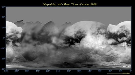
For those who want a combined ISS map and RADAR swath (up to T8) Photoshop file, check out: http://pirlwww.lpl.arizona.edu/~perry/Tita...map.release.psd. I was going to include a VIMS map from T8 and T9, but that ballooned the file to over 164 MB, almost 5 times its current 35 MB size.
-------------------- &@^^!% Jim! I'm a geologist, not a physicist!
The Gish Bar Times - A Blog all about Jupiter's Moon Io |
|
|
|
|
Dec 29 2006, 08:08 PM
Post
#53
|
|
|
Senior Member Group: Members Posts: 1276 Joined: 25-November 04 Member No.: 114 |
QUOTE Happy now? Ummm yes and no! I expected something a little more cleaned up. I'm not bashing your work, I thought it would be a little more cleaned up. Anyways gives all the Photoshop artist and chance to have some fun! Thanks VP! PS Great PDF!!!! |
|
|
|
|
Dec 29 2006, 08:14 PM
Post
#54
|
|
|
Senior Member Group: Moderator Posts: 3233 Joined: 11-February 04 From: Tucson, AZ Member No.: 23 |
Well, I'm still work on smoothing techniques across multiple data sets. I'll admit this one was more of a case of needing to get something out since we haven't had a released map update since January of last year. Unfortunately that's about as cleaned up as I could get it without using destructive low pass filters. The data is already a bit blurry, I see no point in making it worse.
-------------------- &@^^!% Jim! I'm a geologist, not a physicist!
The Gish Bar Times - A Blog all about Jupiter's Moon Io |
|
|
|
|
Dec 29 2006, 08:43 PM
Post
#55
|
|
|
Senior Member Group: Members Posts: 3648 Joined: 1-October 05 From: Croatia Member No.: 523 |
I for one am not underwhelmed by the update as I realized any update couldn't bring much greater resolution than what was already available at Shangri-La. This is probably as high a resolution as we'll get from ISS. One must always keep the expectations reasonable. That's one of the reasons the overdue release delay bothered me, though. That said, I do find the Fensal-Aztlan region to be better defined than Shangri-La. As JRehling said, it appears less grainy. Weren't the pixel scales for the mosaics comparable? Is this a result of different camera parameters / filter combos as the Fensal region looks well defined, albeit including those texture seams? Am I right in assuming you didn't use every flyby that provided repeated coverage (over Fensal), for improved S/N ratio and reduced seaming?
-------------------- |
|
|
|
|
Dec 29 2006, 08:46 PM
Post
#56
|
|
|
Senior Member Group: Moderator Posts: 3233 Joined: 11-February 04 From: Tucson, AZ Member No.: 23 |
The mosaics used in the Fensal-Aztlan region have a higher pixel scale than those used in the Shangri-la region. Maps incorporating Ta and Tb REGMAP and HIRES should be available in a future release.
-------------------- &@^^!% Jim! I'm a geologist, not a physicist!
The Gish Bar Times - A Blog all about Jupiter's Moon Io |
|
|
|
|
Dec 29 2006, 10:18 PM
Post
#57
|
|
|
Senior Member Group: Members Posts: 2488 Joined: 17-April 05 From: Glasgow, Scotland, UK Member No.: 239 |
Well, I for one am far from underwhelmed. A couple of years back, even seeing the 'H' in those early Earth-based images - remember? - seemed beyond belief. Now we're seeing so much more, and with the promise of more to come!
I can wait! Bob Shaw -------------------- Remember: Time Flies like the wind - but Fruit Flies like bananas!
|
|
|
|
|
Dec 29 2006, 11:09 PM
Post
#58
|
|
 Special Cookie Group: Members Posts: 2168 Joined: 6-April 05 From: Sintra | Portugal Member No.: 228 |
QUOTE (Bob Shaw @ Dec 29 2006, 10:18 PM) Well, I for one am far from underwhelmed. A couple of years back, even seeing the 'H' in those early Earth-based images - remember? - seemed beyond belief. Now we're seeing so much more, and with the promise of more to come! I can wait! Bob Shaw Bob is back! Bob is raw! Here's an "HURRAH!" for Bob, the Shaw!
-------------------- "Ride, boldly ride," The shade replied, "If you seek for Eldorado!"
Edgar Alan Poe |
|
|
|
|
Dec 30 2006, 12:38 AM
Post
#59
|
|
|
Senior Member Group: Members Posts: 1276 Joined: 25-November 04 Member No.: 114 |
LOL
|
|
|
|
|
Dec 30 2006, 01:36 AM
Post
#60
|
|
|
Merciless Robot Group: Admin Posts: 8784 Joined: 8-December 05 From: Los Angeles Member No.: 602 |
I for one would love to see a surface temp overlay on all these features (yep...cryovolcano seeker here!
)
-------------------- A few will take this knowledge and use this power of a dream realized as a force for change, an impetus for further discovery to make less ancient dreams real.
|
|
|
|
|
Dec 30 2006, 02:40 AM
Post
#61
|
|
|
Senior Member Group: Members Posts: 1276 Joined: 25-November 04 Member No.: 114 |
^^Maybe next Holiday Season!
|
|
|
|
|
Dec 30 2006, 11:31 AM
Post
#62
|
|||
|
Junior Member Group: Members Posts: 64 Joined: 11-October 05 Member No.: 525 |
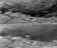
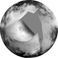
Well, there are some changes on Titan surface!
Mezzoramia looks very pale compared to previous map and two or three white spots appear near 15 and 20 degrees WL. Yet another one white dot encircled in dark near 50 WL 65 SL disappear. What can it be? Really changes, artefacts of processing or just clouds?
Attached thumbnail(s)
|
||
|
|
|
||
|
Dec 30 2006, 06:34 PM
Post
#63
|
|
|
Merciless Robot Group: Admin Posts: 8784 Joined: 8-December 05 From: Los Angeles Member No.: 602 |
Good eye, Olvegg. I'd have to bet on convective clouds, especially for high-latitude features like these; seems like the polar regions are where most of the action's at for Titan's weather.
-------------------- A few will take this knowledge and use this power of a dream realized as a force for change, an impetus for further discovery to make less ancient dreams real.
|
|
|
|
|
Dec 30 2006, 06:52 PM
Post
#64
|
|
|
Senior Member Group: Moderator Posts: 3233 Joined: 11-February 04 From: Tucson, AZ Member No.: 23 |
Yeah, really bright spots at high latitudes are more than likely clouds. It seems that when ever we look at the south polar region at decent enough emission angles that the images can be used in maps, there are clouds down there, so it is hard to remove ALL the clouds from the map.
In terms of contrast difference, I chalk that up to differences in the my sharpening filter in the last 2 years. -------------------- &@^^!% Jim! I'm a geologist, not a physicist!
The Gish Bar Times - A Blog all about Jupiter's Moon Io |
|
|
|
|
Dec 30 2006, 11:16 PM
Post
#65
|
|
|
Member Group: Members Posts: 200 Joined: 20-November 05 From: Mare Desiderii Member No.: 563 |
I've always been surprised that there aren't more amateur Titan ORS mosaics here. (I realise it's a bit of a challenge, but that doesn't usually stop you lot...)
|
|
|
|
|
Dec 31 2006, 12:06 AM
Post
#66
|
|
|
Senior Member Group: Members Posts: 3648 Joined: 1-October 05 From: Croatia Member No.: 523 |
Surprisingly, there aren't a whole lot of people playing around any Cassini images that I can see. Titan would make a pretty hard target to work with, given no easy way to reduce atmospheric haze. You really need excellent flatfields and either you can brew your own ones (hard to do manually) or work with the not so good ones on the calibration volumes. There's a lot to be desired there, especially for the wide-angle camera flatfields which would make simple mosaics easier than taking a shot at high-res NAC footprints. Geometric reprojection would also be handy since the exposures are long and the flybys pretty fast. SPICE kernels in other words...
-------------------- |
|
|
|
|
Dec 31 2006, 02:31 AM
Post
#67
|
|
|
Merciless Robot Group: Admin Posts: 8784 Joined: 8-December 05 From: Los Angeles Member No.: 602 |
Just had an odd thought...Is Titan a cold "desert" planet?
Specifically, it almost seems as if the polar regions are the only areas where precipitation seems to occur with any degree of regularity. If Titan was a terrestrial planet with a similar pattern, the expectation would be that the lower latitudes were too hot to sustain an Earth-style hydrological cycle, and only the poles were temperate enough for habitation...like some of the pre-UMSF ideas about Venus, in some ways. Again, just a thought. No matter how good our maps get, I think that interpreting them within an understandable framework will be a challenge for a LONG time. -------------------- A few will take this knowledge and use this power of a dream realized as a force for change, an impetus for further discovery to make less ancient dreams real.
|
|
|
|
|
Dec 31 2006, 03:49 AM
Post
#68
|
|
|
Senior Member Group: Members Posts: 2530 Joined: 20-April 05 Member No.: 321 |
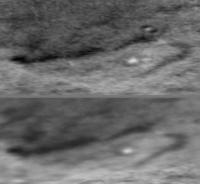
QUOTE (ugordan @ Dec 30 2006, 04:06 PM) Surprisingly, there aren't a whole lot of people playing around any Cassini images that I can see. Titan would make a pretty hard target to work with, given no easy way to reduce atmospheric haze. You really need excellent flatfields and either you can brew your own ones (hard to do manually) or work with the not so good ones on the calibration volumes. Yeah. When the first flybys happened in 2004, I tried my hand at it, with some success, but it was a lot of work to lead to a modest product not that far in advance of the "pro" releases. I attached my work from the first 24 hours of the first flyby in July 2004. I didn't try this again. I used a Hapke map I'd produced for some other world to adjust for phase effects, but I forget which world I had developed the model for. Mercury, I think. Then I just twiddled in Photoshop with no principles but what seemed to look OK. Composite of three ISS frames. |
|
|
|
|
Dec 31 2006, 04:01 AM
Post
#69
|
|
|
Senior Member Group: Members Posts: 1276 Joined: 25-November 04 Member No.: 114 |
Is there any online reference as to how the titan images are produced??
Tricks and Tips!
|
|
|
|
|
Dec 31 2006, 07:45 AM
Post
#70
|
|
 Member Group: Members Posts: 259 Joined: 23-January 05 From: Seattle, WA Member No.: 156 |
QUOTE (nprev @ Dec 31 2006, 02:31 AM) Just had an odd thought...Is Titan a cold "desert" planet? ... Why is that an odd thought? It sure seems a good fit to the available evidence. I wouldn't want to make any firm generalizations about poles vs equatorial regions until we've seen what happens as the equinox approaches, though. I'm hoping Cassini lasts long enough. |
|
|
|
|
Dec 31 2006, 08:08 AM
Post
#71
|
|
|
Senior Member Group: Members Posts: 2488 Joined: 17-April 05 From: Glasgow, Scotland, UK Member No.: 239 |
QUOTE (nprev @ Dec 31 2006, 02:31 AM) Just had an odd thought...Is Titan a cold "desert" planet? Hmm... ...that'd mean camels, wouldn't it? Camels might indicate *life*. If there's life there must be awl (it's a dessert, see?). If there's awl, we better invade! Hey, things are looking up for the unmanned spaceflight budgie! Still, if it's a dessert the proof will always be in the pudding. Bob Shaw -------------------- Remember: Time Flies like the wind - but Fruit Flies like bananas!
|
|
|
|
|
Dec 31 2006, 03:51 PM
Post
#72
|
|
|
Senior Member Group: Members Posts: 1639 Joined: 5-March 05 From: Boulder, CO Member No.: 184 |
QUOTE (Decepticon @ Dec 31 2006, 04:01 AM) Is there any online reference as to how the titan images are produced?? Tricks and Tips! I think there was a CICLOPS release illustrating some of the processing steps. VP may also have mentioned some details. One of the more unique steps involved subtracting an image in a neighboring wavelength (from the 900nm passband) thus acting as a flat field. I suppose having a simple atmospheric model can provide similar flat-fielding information. There were some sharpening steps as well to compensate for the haze diffusion. -------------------- Steve [ my home page and planetary maps page ]
|
|
|
|
|
Dec 31 2006, 07:28 PM
Post
#73
|
|
|
Senior Member Group: Moderator Posts: 3233 Joined: 11-February 04 From: Tucson, AZ Member No.: 23 |
QUOTE (Decepticon @ Dec 30 2006, 09:01 PM) Is there any online reference as to how the titan images are produced?? Tricks and Tips! Check out my LPSC abstract on the subject from a couple of years ago: http://www.lpi.usra.edu/meetings/lpsc2005/pdf/2312.pdf -------------------- &@^^!% Jim! I'm a geologist, not a physicist!
The Gish Bar Times - A Blog all about Jupiter's Moon Io |
|
|
|
|
Dec 31 2006, 08:40 PM
Post
#74
|
|
|
Merciless Robot Group: Admin Posts: 8784 Joined: 8-December 05 From: Los Angeles Member No.: 602 |
QUOTE (Bob Shaw @ Dec 31 2006, 12:08 AM) Hmm... ...that'd mean camels, wouldn't it? Camels might indicate *life*. If there's life there must be awl (it's a dessert, see?). If there's awl, we better invade! Hey, things are looking up for the unmanned spaceflight budgie! Still, if it's a dessert the proof will always be in the pudding. Bob Shaw Well, at least we know the ice cream won't melt...EVER! BTW, does anyone know what the current thinking is as far as 'methane monsoons'? Presumably they occur (if in fact they do) twice per Saturn year as the polar illumination gradually switches, and they probably wouldn't happen precisely at the time of the equinox due to thermal inertia. Any evidence of convective clouds creeping north from the southern hemisphere yet, or even happening further south due to the aformentioned inertia? Some of the features in the equatorial regions remind me more and more of arroyos in the US Southwest. You have to wonder whether the atmosphere becomes supersaturated with methane and then one day just busts loose all over the equator...
-------------------- A few will take this knowledge and use this power of a dream realized as a force for change, an impetus for further discovery to make less ancient dreams real.
|
|
|
|
|
Dec 31 2006, 10:17 PM
Post
#75
|
|
|
Senior Member Group: Members Posts: 2530 Joined: 20-April 05 Member No.: 321 |
QUOTE (nprev @ Dec 31 2006, 12:40 PM) Well, at least we know the ice cream won't melt...EVER! BTW, does anyone know what the current thinking is as far as 'methane monsoons'? Presumably they occur (if in fact they do) twice per Saturn year as the polar illumination gradually switches, and they probably wouldn't happen precisely at the time of the equinox due to thermal inertia. Any evidence of convective clouds creeping north from the southern hemisphere yet, or even happening further south due to the aformentioned inertia? Some of the features in the equatorial regions remind me more and more of arroyos in the US Southwest. You have to wonder whether the atmosphere becomes supersaturated with methane and then one day just busts loose all over the equator... I happened to drive across Arizona on I40 on a snowy day shortly after the second (?) Cassini flyby of Titan and I couldn't help but notice how much it seemed to fit what we knew about Titan. What we know from Voyager and Cassini seems to indicate that the summer pole gets a ring of convection around 80 N/S that creates a lot of rain there. What happens at the equinox or in the dark of the winter pole we don't know yet, but notice that there appear to be lakes in the winter pole now and perhaps at the summer pole as well. I imagine Ralph Lorenz has ventured some opinions. I would guess that the (near) poles get more rain than any other location, enough to fill up lakes that are still full through a decades-long drought. One of the most important things about Cassini's extended mission will be to see what seasonal changes take place on Titan. Bigger cloud structures can be seen from Earth, though, and presumably from the Webb Space Telescope. |
|
|
|
|
Jan 1 2007, 03:09 AM
Post
#76
|
|
|
Merciless Robot Group: Admin Posts: 8784 Joined: 8-December 05 From: Los Angeles Member No.: 602 |
Yeah, JR--I used to live in Tucson, and that's exactly the same impression I got. The entire area is usually dry as a bone all year until monsoon season hits in June/July, and then it's flash-flood time which produces/reinforces all these massive arroyos. Perhaps the same thing happens in Titan's equatorial regions every 14.5 terrestrial years or so...
-------------------- A few will take this knowledge and use this power of a dream realized as a force for change, an impetus for further discovery to make less ancient dreams real.
|
|
|
|
|
Jan 2 2007, 08:35 PM
Post
#77
|
|
|
Senior Member Group: Moderator Posts: 2785 Joined: 10-November 06 From: Pasadena, CA Member No.: 1345 |
Does anyone out there have a hypothesis/explanation for the distinctly swoopy pattern of the overall look of the margin of the of the bright terrain against the dark terrain?
It seems that the bright features have an almost parallel aerodynamic look to them. This is particulary evident in the margins around Shangri-La (basin). This has been fascinating me since the first pass: to my eyes, they look almost like a terrestrial fjord landscape. Could this be resulting from wind deposition of upland (bright) material from cryovolcanic airfall? Or could this be from wind deposition of the organic shizzle which piles up downwind against the bright material? Or is it possible that there has been an equivalent of a past ice age on Titan, with methane snows piling up, forming methane glaciers, and coming down off Xanadu and other upland terrains? Any ideas? -Mike -------------------- Some higher resolution images available at my photostream: http://www.flickr.com/photos/31678681@N07/
|
|
|
|
|
Jan 2 2007, 10:54 PM
Post
#78
|
|
|
Senior Member Group: Members Posts: 2488 Joined: 17-April 05 From: Glasgow, Scotland, UK Member No.: 239 |
QUOTE (Juramike @ Jan 2 2007, 08:35 PM) Does anyone out there have a hypothesis/explanation for the distinctly swoopy pattern of the overall look of the margin of the of the bright terrain against the dark terrain? It seems that the bright features have an almost parallel aerodynamic look to them. This is particulary evident in the margins around Shangri-La (basin). This has been fascinating me since the first pass: to my eyes, they look almost like a terrestrial fjord landscape. -Mike Mike: I don't quite know what 'swoopy' landforms are like, but as for the rest it looks just like the west coast of Scotland - a fjord landscape... ...AIRC, 'Scotland' was indeed one of the nicknames used back in the early days! Bob Shaw -------------------- Remember: Time Flies like the wind - but Fruit Flies like bananas!
|
|
|
|
|
Jan 3 2007, 03:29 PM
Post
#79
|
|
|
Senior Member Group: Members Posts: 2530 Joined: 20-April 05 Member No.: 321 |
QUOTE (Bob Shaw @ Jan 2 2007, 02:54 PM) Mike: I don't quite know what 'swoopy' landforms are like, but as for the rest it looks just like the west coast of Scotland - a fjord landscape... ...AIRC, 'Scotland' was indeed one of the nicknames used back in the early days! Bob Shaw I just went back to the Planetary Sciences Yahoo! group and saw that at 4:09pm on July 2, 2004, I posted: "Image N00006513.jpg... first thing I think of is a map of Scotland." That was about 2 1/2 hours after the first images came down. Took a while to de-haze them enough. My half-considered explanation for the Scottish shape would be that tectonic uplift in this area caused a lot of faulting with the same orientation, with the crust buckling according to different spatial frequencies. Large-scale buckles give the overall shape of Xanadu's northwestern "coast" while small-scale buckles make the whole thing look like corduroy... as do various locations up the Pacific Coast of the Americas, Scotland, and other places on Earth. One of the interesting things is that Xanadu has moderately dark "lochs" near but not part of (or as dark as) Shangri-La. Probably the same sediments that darkened Shangri-La, but in lesser amounts. |
|
|
|
|
Jan 3 2007, 06:22 PM
Post
#80
|
|
|
Senior Member Group: Moderator Posts: 2785 Joined: 10-November 06 From: Pasadena, CA Member No.: 1345 |
QUOTE (JRehling @ Jan 3 2007, 10:29 AM) My half-considered explanation for the Scottish shape would be that tectonic uplift in this area caused a lot of faulting with the same orientation, with the crust buckling according to different spatial frequencies. Large-scale buckles give the overall shape of Xanadu's northwestern "coast" while small-scale buckles make the whole thing look like corduroy... as do various locations up the Pacific Coast of the Americas, Scotland, and other places on Earth. One of the interesting things is that Xanadu has moderately dark "lochs" near but not part of (or as dark as) Shangri-La. Probably the same sediments that darkened Shangri-La, but in lesser amounts. So, the tectonic uplift causes the general buckling....and then the infilling of the lowland basins by the dark material causes a ria (drowned valley) topography? In this case the drowning of the valleys is caused not by a rise in seawater (like on Earth), but by the gradual infilling of the the dark material basins due to the organic "schizzle" raining down? [Thus the dark lochs are shallower accumulations of the organic ooze.] Or is a glacial event still a possibility? -Mike -------------------- Some higher resolution images available at my photostream: http://www.flickr.com/photos/31678681@N07/
|
|
|
|
|
Jan 3 2007, 11:17 PM
Post
#81
|
|
 IMG to PNG GOD Group: Moderator Posts: 2251 Joined: 19-February 04 From: Near fire and ice Member No.: 38 |
QUOTE (JTN @ Dec 30 2006, 11:16 PM) I've always been surprised that there aren't more amateur Titan ORS mosaics here. (I realise it's a bit of a challenge, but that doesn't usually stop you lot...) Yes, this is very surprising. In my case one reason is that all of my recent Cassini image processing has involved a huge map covering Saturn's entire southern hemisphere. See this thread, especially the message I posted there today. QUOTE (ugordan @ Dec 31 2006, 12:06 AM) Surprisingly, there aren't a whole lot of people playing around any Cassini images that I can see. Titan would make a pretty hard target to work with, given no easy way to reduce atmospheric haze. You really need excellent flatfields and either you can brew your own ones (hard to do manually) or work with the not so good ones on the calibration volumes. There's a lot to be desired there, especially for the wide-angle camera flatfields which would make simple mosaics easier than taking a shot at high-res NAC footprints. Geometric reprojection would also be handy since the exposures are long and the flybys pretty fast. SPICE kernels in other words... One idea might be to reduce noise by reprojecting several images of the same (or roughly same) area into a simple cylindrical map containing their 'sum' (a similar idea to superresolution processing). However, this requires extremely accurate pointing information since there are no high contrast features to use as an accurate guide if the results of reprojecting two or more images don't exactly match. The Cassini index files (index.tab) contain viewing geometry information but when making the previously mentioned map of Saturn I got slightly more accurate results by using the SPICE kernels directly. |
|
|
|
|
Jan 17 2007, 01:10 AM
Post
#82
|
|
|
Member Group: Members Posts: 540 Joined: 17-November 05 From: Oklahoma Member No.: 557 |
Edit: Sorry, didn't realize the map had already posted. Should have read the earlier posts.
|
|
|
|
|
Jun 21 2007, 09:47 PM
Post
#83
|
|
|
Senior Member Group: Members Posts: 1639 Joined: 5-March 05 From: Boulder, CO Member No.: 184 |
Greetings,
Here's a real quick 1K Titan map taking the latest official one from late 2006 and overlaying mosaics from a couple of the recent flybys. As usual this can be refined in the future. Perhaps even some north polar radar mosaics can be added if they are on a suitable projection - a certain map I noticed from EC comes to mind. http://laps.noaa.gov/albers/sos/saturn/tit...cyl_070621c.jpg -------------------- Steve [ my home page and planetary maps page ]
|
|
|
|
|
Jun 22 2007, 12:04 AM
Post
#84
|
|
 Member Group: Members Posts: 809 Joined: 11-March 04 Member No.: 56 |
QUOTE (scalbers @ Jun 21 2007, 09:47 PM) Greetings, Here's a real quick 1K Titan map taking the latest official one from late 2006 and overlaying mosaics from a couple of the recent flybys. Very nice! But it gets me thinking again about the global distributions of different terrains and climates on Titan. The overall picture seems clear: Titan is a semi-desert moon, wet at the poles, very dry around the equator, with an equatorial belt of sand-seas in (it seems) lower terrain. Which raises the following questions for me: 1) Why is the equatorial belt so irregular in shape? Just chance variations in elevation? 2) What constrains the desert belt to north and south? Or to put it another way, what's going on in the temperate zone in terrains that would be deserts if they were equatorial? |
|
|
|
|
Jun 22 2007, 04:53 AM
Post
#85
|
|
|
Senior Member Group: Members Posts: 1583 Joined: 14-October 05 From: Vermont Member No.: 530 |
That's nice!
Although a mercator projection centered at the equator distorts exactly what is interesting at Titan...
|
|
|
|
|
Jun 22 2007, 03:00 PM
Post
#86
|
|
|
Senior Member Group: Moderator Posts: 2785 Joined: 10-November 06 From: Pasadena, CA Member No.: 1345 |
Wow! Nice job!
-Mike -------------------- Some higher resolution images available at my photostream: http://www.flickr.com/photos/31678681@N07/
|
|
|
|
|
Jun 22 2007, 03:15 PM
Post
#87
|
|
|
Senior Member Group: Moderator Posts: 2785 Joined: 10-November 06 From: Pasadena, CA Member No.: 1345 |
QUOTE (David @ Jun 21 2007, 08:04 PM) 1) Why is the equatorial belt so irregular in shape? Just chance variations in elevation? Elevation differences, yes. Chance? Maybe not. I suspect Xanadu might be playing a role. It might be acting like Tharsis bulge on Mars. Big cryovolcanic construct, big mass put on surface, gets drifted to equator. Why the Sand Seas are where they are on either side of Xanadu and in approximate line with the Equater is bugging me too. The pattern of Tharsis/Vallis Marineris on Mars and Xanadu/Fensal-Quivra-Azltan = "The Big H" on Titan is eerily similar. Also, since we haven't imaged all of Titan in really good detail, there could be other low-lying Sand Seas in temperate zones as well. (And what would a raised Sand Sea basin look like?) Mezzoramia might be one of these. QUOTE (David @ Jun 21 2007, 08:04 PM) 2) What constrains the desert belt to north and south? Or to put it another way, what's going on in the temperate zone in terrains that would be deserts if they were equatorial? A really good question! Is it elevation? Or is it methane rainfall? Or is it something else entirely? (Maybe the sand sea basins are "special" and the "normal" surface is like the temperate zones.) -Mike -------------------- Some higher resolution images available at my photostream: http://www.flickr.com/photos/31678681@N07/
|
|
|
|
|
Jun 22 2007, 04:13 PM
Post
#88
|
|
|
Senior Member Group: Members Posts: 3419 Joined: 9-February 04 From: Minneapolis, MN, USA Member No.: 15 |
Interesting speculation, Mike. I see your point about the similarities between the Xanadu/Fensal-Quivra-Azltan construct and Mars' Tharsis bulge.
However -- just how efficiently could Titan shift its orientation when locked into a tidal resonance with Saturn? Mars spins very fast, relatively speaking, and has a whole lot more rotational energy with which to shift the entire planet onto its side (so to speak). Titan, in contrast, spins very slowly on its axis and has the very deep Saturnian gravity well to deal with. I'd almost believe that tidal attraction from Saturn would supply more energy to such a process than Titan's own rotational energy could provide. If Titan's mass was redistributed in a manner similar to what happened on Mars, I'd be willing to bet you'd see the thing reach an equilibrium with the "heaviest" part of the mass tidally locked, facing Saturn. Is that what we're seeing here? If not, I have to wonder a bit as to how the mechanism would work... -the other Doug -------------------- The trouble ain't that there is too many fools, but that the lightning ain't distributed right. -Mark Twain
|
|
|
|
|
Jun 22 2007, 06:53 PM
Post
#89
|
|
|
Senior Member Group: Moderator Posts: 2785 Joined: 10-November 06 From: Pasadena, CA Member No.: 1345 |
That's a really good point, David.
Without doing the math (yuk!), I'd guess tidal effects (including eccentricity) would swamp out the rotation rate. So I'd guess it would make more sense for the Xanadu bulge to be at either the Subsaturn point or at the AntiSaturn point. And at longitude 90-100 W, it's pretty much in the wrong spot. Now I'm even more clueless....  -Mike -------------------- Some higher resolution images available at my photostream: http://www.flickr.com/photos/31678681@N07/
|
|
|
|
|
Jun 22 2007, 06:57 PM
Post
#90
|
|
|
Senior Member Group: Members Posts: 3419 Joined: 9-February 04 From: Minneapolis, MN, USA Member No.: 15 |
I'm glad I could confuse you even moreso than before, Mark...
-the other DOUG ( )
-------------------- The trouble ain't that there is too many fools, but that the lightning ain't distributed right. -Mark Twain
|
|
|
|
|
Jun 22 2007, 07:20 PM
Post
#91
|
|
|
Senior Member Group: Moderator Posts: 2785 Joined: 10-November 06 From: Pasadena, CA Member No.: 1345 |
Apologies! I meant "That's a really good point, DOUG".
(With all this new information, the connection between the two hemispheres of Juramike's brain finally snapped. Juramike could never again place the name of an object with it's shape. For the rest of his natural life, Juramike referred to any bowl-like object as "crater" )
-------------------- Some higher resolution images available at my photostream: http://www.flickr.com/photos/31678681@N07/
|
|
|
|
|
Jun 22 2007, 10:20 PM
Post
#92
|
|
|
Senior Member Group: Members Posts: 1639 Joined: 5-March 05 From: Boulder, CO Member No.: 184 |
Hi again,
I've made a few more map updates and increased the size to 4K. This is also now posted on my regular web site at the following URL: http://laps.fsl.noaa.gov/albers/sos/sos.html#TITAN Interesting to see what looks like those long rivers flowing toward the seas of the north pole. -------------------- Steve [ my home page and planetary maps page ]
|
|
|
|
|
Jun 23 2007, 05:05 AM
Post
#93
|
||
|
Senior Member Group: Members Posts: 1887 Joined: 20-November 04 From: Iowa Member No.: 110 |
QUOTE (David @ Jun 21 2007, 07:04 PM) Very nice! But it gets me thinking again about the global distributions of different terrains and climates on Titan. The overall picture seems clear: Titan is a semi-desert moon, wet at the poles, very dry around the equator, with an equatorial belt of sand-seas in (it seems) lower terrain. Which raises the following questions for me: 1) Why is the equatorial belt so irregular in shape? Just chance variations in elevation? 2) What constrains the desert belt to north and south? Or to put it another way, what's going on in the temperate zone in terrains that would be deserts if they were equatorial? Looking at the global view I see three different units: large areas of bright terrain, the dark 'sand seas' forming an incomplete belt around the crater, and below 30 degrees south a gray area. The gray area appears to have been overlooked in these discussions. Anyone have an idea about why it is it different that the bright terrain with a similar latitude in the northern hemisphere?
|
|
|
|
|
|
|
Jun 23 2007, 04:32 PM
Post
#94
|
|
|
Member Group: Members Posts: 813 Joined: 29-December 05 From: NE Oh, USA Member No.: 627 |
Beautiful work ....
Agree that Titan seems to be a desert world but we have to be careful not to carry that analogy too far. Remember that Huygens detected a lot of methane coming out of the ice/hdrocarbon regolith (smurst?) after it impacted. I am REALLY looking forward to better views of the southern pole. We need to understand how the the 7 year summer at the south pole has affected the methane cycle and the geochemistry and geophysics in that region as well. More FUN coming up juramike!!!!!!!! Craig |
|
|
|
|
Jun 23 2007, 07:23 PM
Post
#95
|
|
|
Solar System Cartographer Group: Members Posts: 10164 Joined: 5-April 05 From: Canada Member No.: 227 |
stevesliva said:
"That's nice! Although a mercator projection centered at the equator distorts exactly what is interesting at Titan... " I want to comment on this because I have encountered this elsewhere. The most fundamental cartographic product - and the hardest to make - is the initial global mosaic itself. Once you have it, it can be reprojected into any other form of map with appropriate software. I will post a polar view of Steve's new map later to demonstrate. Don't think of the simple cylindrical map as an end in itself, it's an image database which can be turned into any other map projection, or wrapped around a sphere, or animated... etc. And frankly the simple cylindrical is just about the easiest of those things to make the other products from. I encountered this with my new Eros mosaic - why make an old-fashioned flat map? Why not project it onto a 3-D shape model and animate it? - but where do you think the mosaic to project onto the model comes from in the first place? (oh, and yes, it's not Mercator! It's Simple Cylindrical, where a degree is represented by a specified number of pixels in both E-W or N-S directions. In Mercator the N-S spacing varies away from the equator.) Phil -------------------- ... because the Solar System ain't gonna map itself.
Also to be found posting similar content on https://mastodon.social/@PhilStooke Maps for download (free PD: https://upload.wikimedia.org/wikipedia/comm...Cartography.pdf NOTE: everything created by me which I post on UMSF is considered to be in the public domain (NOT CC, public domain) |
|
|
|
|
Jun 23 2007, 08:44 PM
Post
#96
|
|
|
Senior Member Group: Members Posts: 3516 Joined: 4-November 05 From: North Wales Member No.: 542 |
I can't wait for that polar version. I've been hoping someone would provide a south polar map of Titan for ages. I even posted a request on CICLOPS. So far I've only seen it in small PDF format used as a base for the flyby groundtracks.
|
|
|
|
|
Jun 23 2007, 09:15 PM
Post
#97
|
|||
|
Solar System Cartographer Group: Members Posts: 10164 Joined: 5-April 05 From: Canada Member No.: 227 |
southern hemisphere:
Northern hemisphere:
Phil -------------------- ... because the Solar System ain't gonna map itself.
Also to be found posting similar content on https://mastodon.social/@PhilStooke Maps for download (free PD: https://upload.wikimedia.org/wikipedia/comm...Cartography.pdf NOTE: everything created by me which I post on UMSF is considered to be in the public domain (NOT CC, public domain) |
||
|
|
|
||
|
Jun 23 2007, 09:16 PM
Post
#98
|
|
|
Senior Member Group: Members Posts: 3516 Joined: 4-November 05 From: North Wales Member No.: 542 |
Hallelujah!
|
|
|
|
|
Jun 24 2007, 12:40 AM
Post
#99
|
|
|
Member Group: Members Posts: 809 Joined: 11-March 04 Member No.: 56 |
Beautiful, just beautiful. Now that we've seen the radar of the northern region, it's a little easier to interpret the dark markings at the south pole, although it now becomes a matter of wonder why the 'bean-shaped' lake is, not just a lake, but one with such smooth and nicely curved boundaries, unlike both the northern lakes and the other lakes in its vicinity.
I wonder if the "gray" areas in the temperate zones might be -- I'm not sure of a proper terminology that doesn't imply vegetation, but anyway -- swamp, or wetland -- shallow lacustrine regions that are intermittently (seasonally?) dry, or at any rate more like perpetually damp, methanelogged land, than like lakes, thus perhaps being an intermediate term between the polar lakes and the equatorial deserts, which (as suggested above) might be concealing a fair bit of subterranean moisture as well. |
|
|
|
|
Jun 24 2007, 06:03 AM
Post
#100
|
|
|
Senior Member Group: Members Posts: 1887 Joined: 20-November 04 From: Iowa Member No.: 110 |
QUOTE (David @ Jun 23 2007, 07:40 PM) I wonder if the "gray" areas in the temperate zones might be -- I'm not sure of a proper terminology that doesn't imply vegetation, but anyway -- swamp, or wetland -- shallow lacustrine regions that are intermittently (seasonally?) dry, or at any rate more like perpetually damp, methanelogged land, than like lakes, thus perhaps being an intermediate term between the polar lakes and the equatorial deserts, which (as suggested above) might be concealing a fair bit of subterranean moisture as well. Maybe they aren't perpetually damp. It could be a seasonal change. I'll stick my neck out and make a wild prediction: after the equinox the gray area in the southern hemisphere will brighten and a new gray area will form in the northern hemisphere. Remember, you heard it here first. |
|
|
|
|

|
Lo-Fi Version | Time is now: 19th May 2024 - 10:11 PM |
|
RULES AND GUIDELINES Please read the Forum Rules and Guidelines before posting. IMAGE COPYRIGHT |
OPINIONS AND MODERATION Opinions expressed on UnmannedSpaceflight.com are those of the individual posters and do not necessarily reflect the opinions of UnmannedSpaceflight.com or The Planetary Society. The all-volunteer UnmannedSpaceflight.com moderation team is wholly independent of The Planetary Society. The Planetary Society has no influence over decisions made by the UnmannedSpaceflight.com moderators. |
SUPPORT THE FORUM Unmannedspaceflight.com is funded by the Planetary Society. Please consider supporting our work and many other projects by donating to the Society or becoming a member. |
|