Mission: Hayabusa 2 |

  |
Mission: Hayabusa 2 |
 Oct 20 2018, 10:59 PM Oct 20 2018, 10:59 PM
Post
#631
|
||
|
Solar System Cartographer  Group: Members Posts: 10151 Joined: 5-April 05 From: Canada Member No.: 227 |
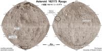
No new details, but this version of the map has an improved base image. The positional control is slightly better as well, so the sites are shifted slightly to match the modified base.
Phil
-------------------- ... because the Solar System ain't gonna map itself.
Also to be found posting similar content on https://mastodon.social/@PhilStooke Maps for download (free PD: https://upload.wikimedia.org/wikipedia/comm...Cartography.pdf NOTE: everything created by me which I post on UMSF is considered to be in the public domain (NOT CC, public domain) |
|
 |
 
|
|
| Guest_mcmcmc_* |
Oct 23 2018, 12:22 PM
Post
#632
|
|
Guests |
|
|
|
|
| Guest_mcmcmc_* |
Oct 24 2018, 06:57 AM
Post
#633
|
|
Guests |
Descent started:
 https://programmi.000webhostapp.com/hayabus...simulator3.html Detailed schedule of the mission is now online: http://www.hayabusa2.jaxa.jp/en/topics/201...D1-R3_Schedule/ This time it won't be just a "almost-touch & go", but the spacecraft will stay at 20m altitude for around 20 minutes, from 02:30 to 02:50 UTC. |
|
|
|
|
Oct 25 2018, 04:17 AM
Post
#634
|
|
 Senior Member Group: Members Posts: 1419 Joined: 26-July 08 Member No.: 4270 |
The Hayabusa 2 twitter feed reports that the target marker was released.
QUOTE [TD1-R3] October 25 at 12:40 JST: Communication with the high-gain antenna (HGA) has resumed & telemetry on the status of the spacecraft is confirmed. The spacecraft is normal. The target marker is confirmed to be separated. The spacecraft is now at an altitude of more than 1200m As is typically the case whenever anything interesting happens, the live image page has stopped updating. -------------------- -- Hungry4info (Sirius_Alpha)
|
|
|
|
| Guest_mcmcmc_* |
Oct 25 2018, 08:02 AM
Post
#635
|
|
Guests |
QUOTE (Hungry4info @ Oct 25 2018, 05:17 AM)  The Hayabusa 2 twitter feed reports that the target marker was released. As is typically the case whenever anything interesting happens, the live image page has stopped updating. Twitter feed reveals that at lowest altitude even the live telemetries were not available due to usage of low-gain antenna, not to mention the high-speed-transmission-demanding images: QUOTE [TD1-R3] October 25, 12:06 JST: Confirmation that the spacecraft has begun to rise. Near the lowest point, the low-gain antenna (LGA) were in use & telemetry wasn’t possible. The spacecraft velocity was monitored with Doppler Data. Low altitude circumstances to be confirmed later https://twitter.com/haya2e_jaxa/status/1055301107495227392 Indeed this resulted in a mess in the live telemetries used by JAXA simulator, resulting in this messed up chart (I cleaned up the calculated speeds, but I can't do anything about wrong readings from LIDAR): 
|
|
|
|
|
Oct 25 2018, 01:27 PM
Post
#636
|
|
|
Senior Member Group: Members Posts: 2082 Joined: 13-February 10 From: Ontario Member No.: 5221 |
An image of the marker on the surface is here: https://twitter.com/haya2e_jaxa/status/1055421132784824320
To think... my name (and hopefully a lot of UMSFers' names are on board that little speck.. AAS Press conference here in a few hours (12:00 EST): https://aas.org/media-press/aas-press-conference-webcasts |
|
|
|
|
Oct 25 2018, 05:16 PM
Post
#637
|
|
 Senior Member Group: Members Posts: 1887 Joined: 20-November 04 From: Iowa Member No.: 110 |
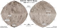
Big boulder on Ryuga's pole is named Otohime.
https://twitter.com/sharponlooker/status/1055499790463746048 |
|
|
|
|
Oct 26 2018, 01:18 AM
Post
#638
|
||
|
Solar System Cartographer Group: Members Posts: 10151 Joined: 5-April 05 From: Canada Member No.: 227 |
Map update! Several changes including the boulder name.
Phil
-------------------- ... because the Solar System ain't gonna map itself.
Also to be found posting similar content on https://mastodon.social/@PhilStooke Maps for download (free PD: https://upload.wikimedia.org/wikipedia/comm...Cartography.pdf NOTE: everything created by me which I post on UMSF is considered to be in the public domain (NOT CC, public domain) |
|
|
|
|
|
|
Oct 26 2018, 05:52 AM
Post
#639
|
|
 Senior Member Group: Members Posts: 1729 Joined: 3-August 06 From: 43° 35' 53" N 1° 26' 35" E Member No.: 1004 |
some amazing selfies of the sampler horn taken by the crowdfunded small monitor camera
http://www.hayabusa2.jaxa.jp/en/topics/20181026e_CAM-H/ |
|
|
|
|
Oct 26 2018, 06:29 AM
Post
#640
|
|
|
Newbie Group: Members Posts: 14 Joined: 30-September 14 Member No.: 7269 |
|
|
|
|
|
Oct 26 2018, 10:55 AM
Post
#641
|
|
|
Senior Member Group: Members Posts: 1074 Joined: 21-September 07 From: Québec, Canada Member No.: 3908 |
Animated sequence of 41 images taken during the second touchdown rehearsal.
|
|
|
|
|
Oct 26 2018, 02:34 PM
Post
#642
|
|
 Senior Member Group: Members Posts: 4246 Joined: 17-January 05 Member No.: 152 |
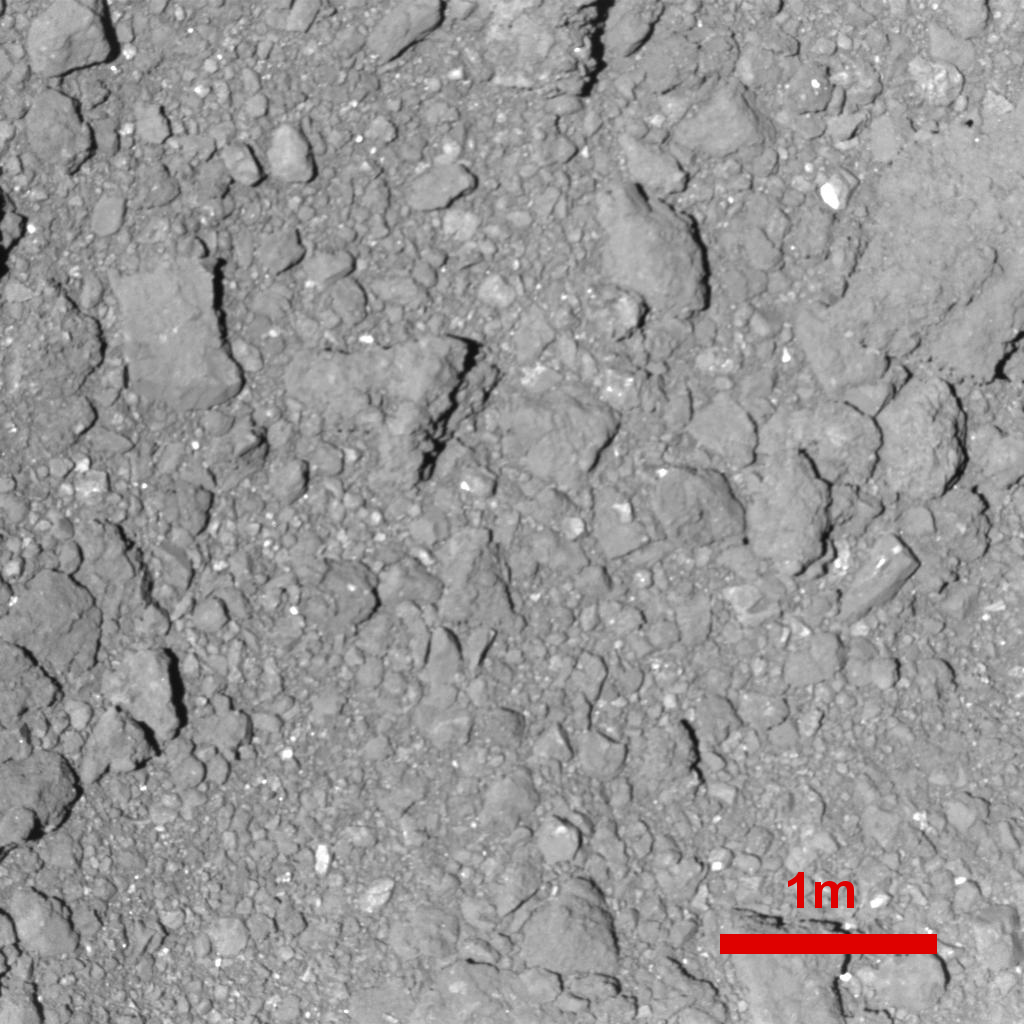
QUOTE (yoichi @ Oct 26 2018, 07:29 AM) The highest resolution image of Ryugu ...not including MINERVA and MASCOT of course. |
|
|
|
|
Oct 27 2018, 03:22 AM
Post
#643
|
|
|
Junior Member Group: Members Posts: 27 Joined: 2-December 14 Member No.: 7359 |
|
|
|
|
|
Oct 29 2018, 05:16 AM
Post
#644
|
|
|
Senior Member Group: Members Posts: 1729 Joined: 3-August 06 From: 43° 35' 53" N 1° 26' 35" E Member No.: 1004 |
very long paper on Hayabusa's cameras:
Updated Inflight Calibration of Hayabusa2's Optical Navigation Camera (ONC) for Scientific Observations during the Cruise Phase QUOTE The Optical Navigation Camera (ONC-T, ONC-W1, ONC-W2) onboard Hayabusa2 are also being used for scientific observations of the mission target, C-complex asteroid 162173 Ryugu. Science observations and analyses require rigorous instrument calibration. In order to meet this requirement, we have conducted extensive inflight observations during the 3.5 years of cruise after the launch of Hayabusa2 on 3 December 2014. In addition to the first inflight calibrations by Suzuki et al. (2018), we conducted an additional series of calibrations, including read-out smear, electronic-interference noise, bias, dark current, hot pixels, sensitivity, linearity, flat-field, and stray light measurements for the ONC. Moreover, the calibrations, especially flat-fields and sensitivities, of ONC-W1 and -W2 are updated for the analysis of the low-altitude (i.e., high-resolution) observations, such as the gravity measurement, touchdowns, and the descents for MASCOT and MINERVA-II payload releases. The radiometric calibration for ONC-T is also updated in this study based on star and Moon observations. Our updated inflight sensitivity measurements suggest the accuracy of the absolute radiometric calibration contains less than 1.8% error for the ul-, b-, v-, Na-, w-, and x-bands based on star calibration observations and ~5% for the p-band based on lunar calibration observations. The radiance spectra of the Moon, Jupiter, and Saturn from the ONC-T show good agreement with the spacecraft-based observations of the Moon from SP/SELENE and WAC/LROC and with ground-based telescopic observations for Jupiter and Saturn.
|
|
|
|
| Guest_mcmcmc_* |
Oct 29 2018, 08:23 AM
Post
#645
|
|
Guests |
Missions profiles analyses:
 Annotated:  Details for TD1-R3:   Recorded telemetries up to now (with additional cleaned up data from noise and errors): https://programmi.000webhostapp.com/hayabus...1-20181027).txt https://programmi.000webhostapp.com/hayabus...181027)-ita.txt (decimal commas) 3d model of terrain from TD1-R1A imageset: https://sketchfab.com/models/a8e3cee4ea9444...4fe1a4f2eef58ed |
|
|
|
|

|
Lo-Fi Version | Time is now: 26th April 2024 - 07:59 AM |
|
RULES AND GUIDELINES Please read the Forum Rules and Guidelines before posting. IMAGE COPYRIGHT |
OPINIONS AND MODERATION Opinions expressed on UnmannedSpaceflight.com are those of the individual posters and do not necessarily reflect the opinions of UnmannedSpaceflight.com or The Planetary Society. The all-volunteer UnmannedSpaceflight.com moderation team is wholly independent of The Planetary Society. The Planetary Society has no influence over decisions made by the UnmannedSpaceflight.com moderators. |
SUPPORT THE FORUM Unmannedspaceflight.com is funded by the Planetary Society. Please consider supporting our work and many other projects by donating to the Society or becoming a member. |
|