Updated Titan Map |

  |
Updated Titan Map |
 Feb 6 2020, 05:41 PM Feb 6 2020, 05:41 PM
Post
#256
|
|
|
Senior Member  Group: Members Posts: 1075 Joined: 21-September 07 From: Québec, Canada Member No.: 3908 |
The style of this map reminds me of Middle-earth.
|
 |
 
|
|
Feb 6 2020, 06:36 PM
Post
#257
|
|
|
Senior Member Group: Members Posts: 1592 Joined: 14-October 05 From: Vermont Member No.: 530 |
QUOTE (charborob @ Feb 6 2020, 12:41 PM)  The style of this map reminds me of Middle-earth. Yes, but are there right angles?  Nice! Some of the context links: https://pirlwww.lpl.arizona.edu/~perry/RADA...8_v00.part2.jpg (relevant swath) https://data.caltech.edu/tindfiles/serve/30...7-0563faefd247/ (global with labels) |
|
|
|
|
Feb 6 2020, 10:40 PM
Post
#258
|
|
|
Solar System Cartographer Group: Members Posts: 10229 Joined: 5-April 05 From: Canada Member No.: 227 |
That piece about the mountains of Middle Earth doesn't hold up when you look beyond the Americas. Check out Siberia, Iran. the vast region north of India, not to mention the Balkans. As a Tolkien fan from long ago and far away, I don't have a problem with his map...or Titan's mountains. Or especially this new map.
Phil -------------------- ... because the Solar System ain't gonna map itself.
Also to be found posting similar content on https://mastodon.social/@PhilStooke Maps for download (free PDF: https://upload.wikimedia.org/wikipedia/comm...Cartography.pdf NOTE: everything created by me which I post on UMSF is considered to be in the public domain (NOT CC, public domain) |
|
|
|
|
Feb 7 2020, 09:47 AM
Post
#259
|
|
|
Merciless Robot Group: Admin Posts: 8785 Joined: 8-December 05 From: Los Angeles Member No.: 602 |
What an outstanding work of visualization! Great outreach tool, too. Very, very impressive, Nick.

-------------------- A few will take this knowledge and use this power of a dream realized as a force for change, an impetus for further discovery to make less ancient dreams real.
|
|
|
|
|
Mar 19 2020, 06:49 PM
Post
#260
|
|
 Lord Of The Uranian Rings Group: Members Posts: 798 Joined: 18-July 05 From: Plymouth, UK Member No.: 437 |
That's stunning, Nick!
-------------------- |
|
|
|
|
Jun 8 2020, 09:16 PM
Post
#261
|
|
 Member Group: Members Posts: 241 Joined: 13-October 09 From: Olympus Mons Member No.: 4972 |
Hey, I don't know if any of you remember me but, I used to drop by once in a while asking for stuff like "reprojected maps of Io" etc.
That was back when I had a weaker computer and Google Earth didn't allow maps to cross the international dateline. Ever since then, I have got a better computer and after the lockdown began, I had time to to update my collection of maps and the Google Earth Solar System overlay. I noticed that there was no updated map combining the ISS map with the HiSAR map but I found some separate ones in USGS Astrogeology. What I did was I got the ISS and HiSAR maps and combined them into one map. Then I added color from the Huygens lander images to the whole globe. The image is 16K so it is suitable for both Google Earth and Celestia. I didn't do any fancy stuff and the noise from the original USGS maps are still there but it was something I wanted to do since the only map combining HiSAR with ISS was from T71 (July 2010) and it's only 11K B/W. The map is up to date as of T104 (January 2015) Here s a link to the full size version. (16K) https://www.flickr.com/photos/60012030@N02/...eposted-public/ (2K thumbnail) 
-------------------- "Thats no moon... IT'S A TRAP!"
|
|
|
|
|
Jun 10 2020, 06:59 AM
Post
#262
|
|
|
Senior Member Group: Members Posts: 3516 Joined: 4-November 05 From: North Wales Member No.: 542 |
How could we forget? Many thanks for making and sharing that. New Titan map products are always welcome.
|
|
|
|
|
Jun 10 2020, 10:05 PM
Post
#263
|
|
 Senior Member Group: Members Posts: 1669 Joined: 5-March 05 From: Boulder, CO Member No.: 184 |
Very nice to see this Antdoghalo. I wonder how it might look if the radar component is overlain on the ISS-based map from Ian Regan?
http://www.unmannedspaceflight.com/index.p...st&p=240167 https://www.flickr.com/photos/10795027@N08/43023455582/ -------------------- Steve [ my home page and planetary maps page ]
|
|
|
|
|
Jun 11 2020, 01:24 PM
Post
#264
|
|
|
Member Group: Members Posts: 241 Joined: 13-October 09 From: Olympus Mons Member No.: 4972 |
This was mainly an experimental thing I did (I didn't think my computer was able to even work on it. It took 20 minutes to complete each task of the process over a few hours but the computer pulled through like the little engine that could). I have since noticed there are some other planetary objects where lower resolution data from older spacecraft could be used to fill in unmapped areas like Phoebe, Charon, and Pluto (which you did a good job adding, Albers). One thing I hope eventually does happen is a map gets released showing radar coverage up to T126 in spring 2017, only then can we have the ultimate updated map of Titan until another probe visits.
I could take a shot at combining Ian's map with the USGS radar map later on this summer. -------------------- "Thats no moon... IT'S A TRAP!"
|
|
|
|
|
Jun 26 2020, 03:30 PM
Post
#265
|
|
|
Member Group: Members Posts: 241 Joined: 13-October 09 From: Olympus Mons Member No.: 4972 |
 https://www.flickr.com/photos/60012030@N02/...eposted-public/ Well, I combined them and the shading is a disaster between the two maps. While it is nice to have increased resolution (and see a couple more of the North Polar lakes,) its so bad I wonder if simply inverting the brightness would actually make it look better. My computer was barely able to make this hulking monstrosity after a couple crashes with GIMP. Someone with a much stronger computer would have to dedicate a lot of time to eliminating the brightness inconsistencies. I've tried to look for an updated RADAR map up to T126 prior to mission's end but I cannot find one. The later swaths not included in this one cover a lot of the unmapped areas. -------------------- "Thats no moon... IT'S A TRAP!"
|
|
|
|
|
Jun 26 2020, 08:06 PM
Post
#266
|
|
|
Solar System Cartographer Group: Members Posts: 10229 Joined: 5-April 05 From: Canada Member No.: 227 |
I don't think inverting the brightness is the solution. Making the radar layer partially transparent (50%, or varied a bit to see how 40 and 60 look) might be a better option.
Phil -------------------- ... because the Solar System ain't gonna map itself.
Also to be found posting similar content on https://mastodon.social/@PhilStooke Maps for download (free PDF: https://upload.wikimedia.org/wikipedia/comm...Cartography.pdf NOTE: everything created by me which I post on UMSF is considered to be in the public domain (NOT CC, public domain) |
|
|
|
|
Jun 26 2020, 10:44 PM
Post
#267
|
||
 Member Group: Members Posts: 349 Joined: 20-June 07 From: Slovenia Member No.: 2461 |
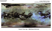
My take at the map in question....There is ISS base overlaid by radar data up to T-104 and false-colored by VIMS data...Can post bigger one in pdf if there is interest... |
|
|
|
|
|
|
Jun 26 2020, 10:52 PM
Post
#268
|
|||
|
Member Group: Members Posts: 349 Joined: 20-June 07 From: Slovenia Member No.: 2461 |
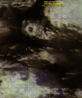
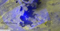
Close up of the Selk crater area and a bluish render of the Kraken Sea.....
Attached thumbnail(s)
|
||
|
|
|
||
|
Jun 26 2020, 10:58 PM
Post
#269
|
||
|
Member Group: Members Posts: 349 Joined: 20-June 07 From: Slovenia Member No.: 2461 |
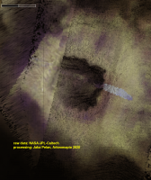
Selk crater at the highest resolution..... |
|
|
|
|
|
|
Jun 30 2020, 05:52 PM
Post
#270
|
|
|
Member Group: Members Posts: 241 Joined: 13-October 09 From: Olympus Mons Member No.: 4972 |
Here is a near perfect version. (2K thumb of 16K image)
https://www.flickr.com/photos/60012030@N02/...eposted-public/  While making a map of Mars, I discovered a tool in GIMP that was perfect for this. Now it looks like a normal ISS map at first glance but upon zooming in, one would find this map holds a LOT of surprises!!! BTW, nice color maps Kymani -------------------- "Thats no moon... IT'S A TRAP!"
|
|
|
|
|

|
Lo-Fi Version | Time is now: 25th September 2024 - 08:48 PM |
|
RULES AND GUIDELINES Please read the Forum Rules and Guidelines before posting. IMAGE COPYRIGHT |
OPINIONS AND MODERATION Opinions expressed on UnmannedSpaceflight.com are those of the individual posters and do not necessarily reflect the opinions of UnmannedSpaceflight.com or The Planetary Society. The all-volunteer UnmannedSpaceflight.com moderation team is wholly independent of The Planetary Society. The Planetary Society has no influence over decisions made by the UnmannedSpaceflight.com moderators. |
SUPPORT THE FORUM Unmannedspaceflight.com is funded by the Planetary Society. Please consider supporting our work and many other projects by donating to the Society or becoming a member. |
|