The Top of Vera Rubin Ridge Part 1, Site 66-67, sol 1812-1943, 11 Sep 2017-23 Jan 2018 |

  |
The Top of Vera Rubin Ridge Part 1, Site 66-67, sol 1812-1943, 11 Sep 2017-23 Jan 2018 |
 Nov 7 2017, 02:12 PM Nov 7 2017, 02:12 PM
Post
#121
|
|
|
Senior Member  Group: Members Posts: 1074 Joined: 21-September 07 From: Québec, Canada Member No.: 3908 |
Sol 1866 Lmastcam:

|
 |
 
|
|
Nov 7 2017, 06:31 PM
Post
#122
|
|
|
Member Group: Members Posts: 122 Joined: 19-June 07 Member No.: 2455 |
What an amazing view of the path ahead. Does anyone know the height of some of those large mesas at the base of Mt. Sharp? So hard to get a feel of scale in these photos. I remember early in the mission the first high res shots of that area there was a boulder down at the base of one of them and it was supposedly taller than the rover and it looked tiny in comparison to the hill beside it.
|
|
|
|
|
Nov 7 2017, 06:55 PM
Post
#123
|
|
|
Member Group: Admin Posts: 976 Joined: 29-September 06 From: Pasadena, CA - USA Member No.: 1200 |
QUOTE (Art Martin @ Nov 7 2017, 10:31 AM)  What an amazing view of the path ahead. Does anyone know the height of some of those large mesas at the base of Mt. Sharp? So hard to get a feel of scale in these photos. I remember early in the mission the first high res shots of that area there was a boulder down at the base of one of them and it was supposedly taller than the rover and it looked tiny in comparison to the hill beside it. This should give you a rough idea: https://hirise-pds.lpl.arizona.edu/PDS/EXTR...1750_U01.ca.jpg Paolo -------------------- Disclaimer: all opinions, ideas and information included here are my own,and should not be intended to represent opinion or policy of my employer.
|
|
|
|
|
Nov 7 2017, 07:39 PM
Post
#124
|
|
|
Member Group: Members Posts: 923 Joined: 10-November 15 Member No.: 7837 |
If you have a Daydream or GearVR phone [ or phone supporting VR ] or HMD you can visit this area in person. The mesas are frickin' huge.
Sketchfab -------------------- |
|
|
|
|
Nov 10 2017, 09:31 AM
Post
#125
|
||
|
Senior Member Group: Members Posts: 2820 Joined: 22-April 05 From: Ridderkerk, Netherlands Member No.: 353 |
The Navcam L view on Sol 1869.
Jan van Driel
|
|
|
|
|
|
|
Nov 10 2017, 04:28 PM
Post
#126
|
|
|
Member Group: Members Posts: 910 Joined: 4-September 06 From: Boston Member No.: 1102 |
The rim is so clear now--dust must be very low!
-------------------- |
|
|
|
|
Nov 10 2017, 06:13 PM
Post
#127
|
||
|
Solar System Cartographer Group: Members Posts: 10153 Joined: 5-April 05 From: Canada Member No.: 227 |
Yes, it's great to see the rim again so clearly.
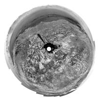
Here is Jan's panorama from sol 1869 in circular form. We are in a recess in this small topographic step on the ridge, probably ready to climb it now. Let's hope that drill can be used on the ridge before we have to move on. Phil
-------------------- ... because the Solar System ain't gonna map itself.
Also to be found posting similar content on https://mastodon.social/@PhilStooke Maps for download (free PD: https://upload.wikimedia.org/wikipedia/comm...Cartography.pdf NOTE: everything created by me which I post on UMSF is considered to be in the public domain (NOT CC, public domain) |
|
|
|
|
|
|
Nov 10 2017, 10:56 PM
Post
#128
|
|
|
Member Group: Members Posts: 910 Joined: 4-September 06 From: Boston Member No.: 1102 |
Any chance this is a walk around to understand the overall diversity of rock types, and when done, possibly go back down the hill to an older layer to start drill sampling?
-------------------- |
|
|
|
|
Nov 10 2017, 11:45 PM
Post
#129
|
|
|
Solar System Cartographer Group: Members Posts: 10153 Joined: 5-April 05 From: Canada Member No.: 227 |
I really can't see a return to the lower surface north of the ridge. That geologic unit had been drilled further north, and examined at almost every stop by ChemCam and APXS along the way.
Phil -------------------- ... because the Solar System ain't gonna map itself.
Also to be found posting similar content on https://mastodon.social/@PhilStooke Maps for download (free PD: https://upload.wikimedia.org/wikipedia/comm...Cartography.pdf NOTE: everything created by me which I post on UMSF is considered to be in the public domain (NOT CC, public domain) |
|
|
|
|
Nov 11 2017, 12:00 AM
Post
#130
|
|
|
Member Group: Members Posts: 910 Joined: 4-September 06 From: Boston Member No.: 1102 |
I was thinking older and younger layers of Vera Rubin Ridge, not all the way back down.
-------------------- |
|
|
|
|
Nov 11 2017, 06:32 AM
Post
#131
|
||
 Senior Member Group: Members Posts: 2428 Joined: 30-January 13 From: Penang, Malaysia. Member No.: 6853 |
Question for the group: I used to get the approximate elevation of Curiosity from the JPL traverse maps posted here, but JPL have not updated the maps since sol 1830. I'm guessing I could obtain elevation from NAIF or maybe from the JSON files. Not sure how easy that would be, but likely beyond my skill-set. So I'm hoping there could be another source for that data without having to await the PDS....
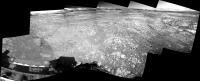
In the meantime here's a (very rough & ready) Curiosity Sol 1871 L-NavCam partial pan assembled in MS ICE, the stitch is poor, but the scenery is lovely.
|
|
|
|
|
|
|
Nov 11 2017, 07:33 PM
Post
#132
|
||
|
Senior Member Group: Members Posts: 2820 Joined: 22-April 05 From: Ridderkerk, Netherlands Member No.: 353 |
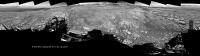
The Navcam L view on Sol 1871.
Jan van Driel
|
|
|
|
|
|
|
Nov 11 2017, 07:39 PM
Post
#133
|
|
 Member Group: Members Posts: 684 Joined: 24-July 15 Member No.: 7619 |
QUOTE (Phil Stooke @ Nov 11 2017, 12:45 AM) I really can't see a return to the lower surface north of the ridge. That geologic unit had been drilled further north, and examined at almost every stop by ChemCam and APXS along the way. Phil But, if you don't drill actual bedrock, how would you know it's the same geologic unit? |
|
|
|
|
Nov 11 2017, 08:38 PM
Post
#134
|
||
 Member Group: Members Posts: 809 Joined: 3-June 04 From: Brittany, France Member No.: 79 |
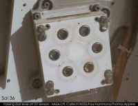
I made an animation with the 25 MAHLI dust level checks of REMS UV sensors that Paul selected.
The distribution of dust changes between sols 1498 and 1552: while dust was evenly distributed on the ring-shaped magnets before sol 1498, it then forms accumulations, as if the fine fraction of dust had been blown away by a wind event. We also observe this dust accumulation on the left side of the REMS device.
Higher resolution version of the animation here. -------------------- |
|
|
|
|
|
|
Nov 11 2017, 09:25 PM
Post
#135
|
|
|
Solar System Cartographer Group: Members Posts: 10153 Joined: 5-April 05 From: Canada Member No.: 227 |
"But, if you don't drill actual bedrock, how would you know it's the same geologic unit?"
All the ChemCam and APXS data, plus geological interpretation of HiRISE and rover images. The rover updates at JPL have made clear the interpretation being followed by the rover team. This ridge is a new unit. To go back to the earlier question, which I misinterpreted, certainly there might be a return to lower units on the top of the ridge if variations in ChemCam and APXS (plus Mastcam multispectral) suggest it's useful, otherwise one drill site may be enough. Anyhoo, here is Jan's 1871 panorama in circular form. Phil -------------------- ... because the Solar System ain't gonna map itself.
Also to be found posting similar content on https://mastodon.social/@PhilStooke Maps for download (free PD: https://upload.wikimedia.org/wikipedia/comm...Cartography.pdf NOTE: everything created by me which I post on UMSF is considered to be in the public domain (NOT CC, public domain) |
|
|
|
|

|
Lo-Fi Version | Time is now: 28th April 2024 - 03:52 AM |
|
RULES AND GUIDELINES Please read the Forum Rules and Guidelines before posting. IMAGE COPYRIGHT |
OPINIONS AND MODERATION Opinions expressed on UnmannedSpaceflight.com are those of the individual posters and do not necessarily reflect the opinions of UnmannedSpaceflight.com or The Planetary Society. The all-volunteer UnmannedSpaceflight.com moderation team is wholly independent of The Planetary Society. The Planetary Society has no influence over decisions made by the UnmannedSpaceflight.com moderators. |
SUPPORT THE FORUM Unmannedspaceflight.com is funded by the Planetary Society. Please consider supporting our work and many other projects by donating to the Society or becoming a member. |
|